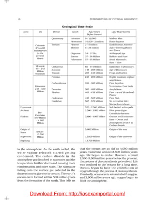
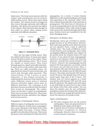
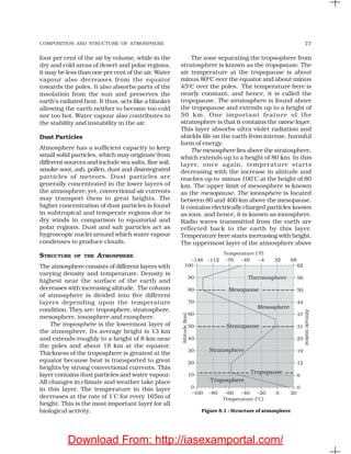
This document discusses geography as an academic discipline. It covers the following key points in 3 sentences:
Geography integrates knowledge from natural and social sciences to study spatial variations and relationships between physical environments and human activities. It examines phenomena based on location ("where"), patterns ("what"), and causal relationships ("why") to understand interactions between nature and humans over time and space. As an integrating discipline, geography uses a holistic approach to synthesize data from fields like geology, meteorology, history, economics and sociology to comprehend different aspects of reality from a spatial perspective.


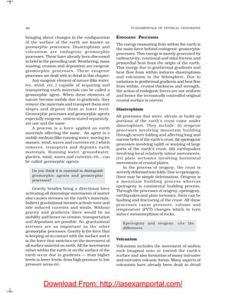


![ATMOSPHERIC CIRCULATION AND WEATHER SYSTEMS 93
Land and Sea Breezes
As explained earlier, the land and sea absorb
and transfer heat differently. During the day the
land heats up faster and becomes warmer than
the sea. Therefore, over the land the air rises
giving rise to a low pressure area, whereas the
sea is relatively cool and the pressure over sea
is relatively high. Thus, pressure gradient from
sea to land is created and the wind blows from
the sea to the land as the sea breeze. In the night
the reversal of condition takes place. The land
loses heat faster and is cooler than the sea. The
pressure gradient is from the land to the sea
and hence land breeze results (Figure 10.7).
Figure 10.7 : Land and sea breezes
Mountain and Valley Winds
In mountainous regions, during the day the
slopes get heated up and air moves upslope
and to fill the resulting gap the air from the
valley blows up the valley. This wind is known
as the valley breeze. During the night the
slopes get cooled and the dense air descends
into the valley as the mountain wind. The cool
air, of the high plateaus and ice fields draining
into the valley is called katabatic wind. Another
type of warm wind occurs on the leeward side
of the mountain ranges. The moisture in these
winds, while crossing the mountain ranges
condense and precipitate. When it descends
down the leeward side of the slope the dry air
gets warmed up by adiabatic process. This dry
air may melt the snow in a short time.
Air Masses
When the air remains over a homogenous area
for a sufficiently longer time, it acquires the
characteristics of the area. The homogenous
regions can be the vast ocean surface or vast
plains. The air with distinctive characteristics
in terms of temperature and humidity is called
an airmass. It is defined as a large body of air
having little horizontal variation in temperature
and moisture. The homogenous surfaces, over
which air masses form, are called the source
regions.
The air masses are classified according to
the source regions. There are five major source
regions. These are: (i) Warm tropical and
subtropical oceans; (ii) The subtropical hot
deserts; (iii) The relatively cold high latitude
oceans; (iv) The very cold snow covered
continents in high latitudes; (v) Permanently
ice covered continents in the Arctic and
Antarctica. Accordingly, following types of air-
masses are recognised: (i) Maritime tropical
(mT); (ii) Continental tropical (cT); (iii) Maritime
polar (mP); (iv) Continental polar (cP);
(v) Continental arctic (cA). Tropical air masses
are warm and polar air masses are cold.
Fronts
When two different air masses meet, the
boundary zone between them is called a front.
The process of formation of the fronts is known
as frontogenesis. There are four types of
fronts: (a) Cold; (b) Warm; (c) Stationary;
(d) Occluded [(Figure10.8 (a), (b), (c)]. When the
front remains stationary, it is called a
stationary front. When the cold air moves
Download From: http://iasexamportal.com/](https://image.slidesharecdn.com/geography-11th-ncert-151119111313-lva1-app6892/85/Geography-11th-ncert-94-320.jpg)


![GEOGRAPHY-WPS-Office [Autosav.....ed].pptx](https://cdn.slidesharecdn.com/ss_thumbnails/geography-wps-officeautosaved-250309073130-b5d8c98e-thumbnail.jpg?width=640&height=640&fit=bounds)


