
Recommended
Recommended
More Related Content
What's hot
What's hot (20)
Similar to Land use policy of Bangladesh
Similar to Land use policy of Bangladesh (20)
More from Nur E Sowrove
More from Nur E Sowrove (9)
Recently uploaded
Recently uploaded (20)
Land use policy of Bangladesh
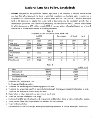
- 1. 1 National Land Use Policy, Bangladesh 1. Context: Bangladesh is an agricultural country. Agriculture is the one third of national income source and two third of employment. So there is unlimited importance on land and water resource use in Bangladesh.130 million people lives in 14.4 million hector with per capitaland of 27 decimals and tillable land of 17 decimals per capita. Per capita land is decreasing due to population growth. Due to urbanization agricultural land is decreasing day by day. Total tillable land was 20.2 million acres in 1983- 84 which decreased to 17.5 million acres in 1997. A common picture of availability and use of land & various use of tillable land is shown in following two tables. Table-1 Bangladesh: Land availability & use, 1974-1996 In 1000 acres Percentage Of total land Year 1974 1990 1996 1974 1990 1996 Total land 35282 37521 36664 100 100 100 Tillable land 23199 23209 21560 66 62 59 Net cultivated land 20977 21837 19280 59 58 53 Tillable fallow land 2221 1372 2281 7 4 6 Forest land 5508 8591 5315 16 12 14 Uncultivable 6576 9721 9788 19 26 27 Table-2 (In 1000 acres) Year 1983-84 1997 Tillable land 22676 20209 Cultivated land 20238 17449 Tillable fallow land 2436 2760 Residential 857 1027 Reference: BBS Bangladesh, 1998. 2. Purpose of land use policy: a. To reduce the decreasing rate of reducing agricultural land b. To control the unplanned growth of residential area through Zoning system according to nature of land. c. To ensure the best use of alluvial land (char land) d. Preservation of future potential and government khash land e. To ensure land use is favorable to ecology f. Best use of land for poverty alleviation & employment and to reduce trend of increasing landless people. g. Saving natural forest, blocking river erosion & reduce hill track damage h. To prevent soil pollution i. Ensure minimum land use through building multistoried government & private building for institutions.
- 2. 2 3. Zone selection according to land use: I. Marking land area according to special use. Residential area should be logically far away from trade or industrial area. II. Town Improvement Act, 1953 is not followed in many cities. Residential and industrial area are built unplanned. This needs quick solution. III. The need for a “Village Improvement Act” as there is no control in land use there. IV. Fixation of present and future residential area according to ecological principle. Use of geologically important land and government control over them. V. Creation of zoning map according to use in city corporation. Residential, trade & industrial area are three main zones to be considered. VI. Vast land outside of city area should also be ensured of best use. VII. Zoning law in national level to create a national zoning map. VIII. Training of personnel from city corporation, municipal, district council & thana council and elected political representatives on zoning and zoning map under various training institutions. 4. Sectors of land use: Mainly following sectors uses most lands in Bangladesh: I. Agriculture II. Housing III. Forest IV. River, irrigation & drainage, pond V. Road VI. Railway VII. Trade & industrial institutions VIII. Tea, rubber & horticultural garden IX. Coastal area X. Alluvial land XI. others 5. Agricultural Production: a. Grain production increased in current times but we still have to import 4.5 lakh ton grain. Fertility of land is also decreasing due to unplanned & uncontrolled land use. b. In 1980s only 15% of land were being used on nonagricultural use today it increased to 30%. Agricultural land is decreasing day by day due to nonagricultural land. c. 25% of acquisitioned land is being misused. This kind of misuse must be misused. d. Though agricultural land is private property it should be used according to national and social necessities. Land use should ensure enough food for population while also protecting small and landless farmers. Decreasing trend of agricultural land should be prevented. e. Best use of land according to national agricultural policy. Blocking of desertification through planned irrigation mapping. Stopping nonagricultural use of agricultural land.
- 3. 3 6. Housing: - Rapid urbanization and rural to urban migration posts pressure on land use. - On the other hand, more and more lands are being used to accommodate increasing population - Agricultural land is decreasing due to housing - In this situation steps should be taken to implement strict rules on housing at city area and also minimum use in housing expansion in village areas. - City corporation, district council and Thana council should follow fixed rules to well control the situation. - At city area expansion of trade and industry in residential area should be checked. - Local government should insist on not expanding housing on fertile land. 7. Forestland: - Everybody knows the importance of forestland for ecological balance. - Most of the forestland of the country are situated in hill tract Chittagong, Sylhet area, Madhupur area, Sundorban etc. - Climate specialists insist that every country should have forestland at least 25% of its total land to maintain the ecological balance. - Bangladesh is very low in this scale. - So air pollution due to mechanization must be checked. - With forestation this air pollution could be checked to huge extent. - Creating large forests in reserve forest & other forestland and protection of present available forestland is very important. - Current situation is hoped to improve if Climate policy 1992 & National forest policy, 1994 is implemented properly. 8. Industrialization: - 8.1 In order to survive in free market economy, we need to take steps for industrialization. - Favorable condition needs to be created for industry establishment in order to sell goods in competitive price both in national and international market. - In Dhaka, Chittagong and Khulna huge amount of land are selected by BSCIC in order to industry establishment but it’s not done as expected. - Acquisitioned lands are remained idle and industry entrepreneurs are not getting necessary land though there are enough free plots. - 8.2 Important factors for site selection to establish mills and factories are suitable transportation system, tax exemption facility, sufficient electricity and gas supply etc. - Approximately 1500 feet land would be kept for industrialization as business and industrial area are being established alongside main roads. - If the owners of allotted plots are not interested in establishing industry within a certain period, those plot will be distributed again who are really interested in that. - Any other small and cottage industry establishment may be discouraged inside the radius of 10 km in BSCIC industrial area if there is enough place. - Ministry of trade might be more active in order to make necessary steps.
- 4. 4 9. Wetland: - 9.1 There is approximately 25000 long river way in this country. Around 1.4-million-ton fish are produced in around 4.3 million ha area of rivers and other wetlands. - We are lagging behind in potential fish production. - According to fifth five-year plan now we can attain the target of fish production progress up to 2 million tons if fish cultivation is done in scientific way in open and closed wetland. - 9.2 Wetlands are decreasing because of many reasons which creates several problems that are given below: - 1. Increase the possibility of flood during monsoon. - 2. Lack of sufficient water for river way transportation during dry season. - 3. Limited fish cultivation. - 4. Insufficient water for irrigation - 5. Salinity increase - 6. Water clogging problem - 7. Lack of water for household chores - 9.3 It should be ensured that traditional sectors for fish production such as rivers, canal-bills, haor-baor etc. are not affected. - There is a tendency of transforming the wetland into agricultural land during dry season but it should be kept in mind that expanding the agricultural land is not a solution. - Rather it creates many problems like unbalancing ecology, creation of deficit in fish protein due to population. - Steps should be taken according to national agricultural and fisheries policy to increase production of both agriculture and fishery. - Tea garden in Sylhet and Chittagong is a large share of our export earnings. - There are rubber gardens in hill tract Chittagong and some other areas - This kind of special gardens should be protected and improved. - Lands used in this purpose should not be allowed to use in any other purpose. - Trees in this lands should not be destroyed and fertility of these lands should not be harmed. 10. Coastal Area: - Northern part of the country many large alluvial lands are forming and will continue to form. - Though artificial alluvial land creation is costly, it can be done under national consideration. - Forestation, allocation of land to landless housing, drinkable water source and drainage, improved cultivation shelter against cyclone etc. should be managed in this lands. - This needs national level planning. - It is possible through forming of an Inter-ministry taskforce to undergo the process. 11. Alluvial land area: (চরাঞ্চল) - Steps are being taken to accommodate landless people in newly created alluvial lands throughout the country according to present policy. - Rehabilitation of river erosion area people should get the priority in this endeavor.
- 5. 5 12. Other use of land: - 12.1 There are many other reasons behind increasing land use let alone the discussed ones. - Use of land in socio-cultural improvement of the country like- Educational institute, playground, marketplace, office-court, work and residential place for military, dairy & poultry farm takes a great share of the total land. - Even now there is a consistent pressure on increasing this kind of establishments. - A limit in these ventures could easily be implemented. - Assuring of highest use in already allotted plots for these purposes. - If land is necessary after the highest possible use in these institutions then additional land use is advised to be kept at minimum level. - Dredging of river is done to protect the flow of water and irrigation usefulness. - The soil acquired in these dredging processes could be used in planned way to protection and improvement activity of land. - 12.2 Motivating people to use cement, sand & stone made hollow block instead of Brick to check the bad effects of brick use & unplanned brick field on natural and climatic condition. - It also reduces the damage in case of earthquake 13. Misuse of Acquisitioned land: - 13.1 One fourth of acquisitioned land is either being misused or under illegal occupation. - Reclamation of these lands according to law with help of related ministries is possible - Rescued lands could again be listed as government khash land - List of khash land should include and regularly correct the mentioning of reclaimed lands. - 13.2 Related law could be reformed to permit multilateral use of these acquisitioned land in government, autonomous or half autonomous institutes without hampering the main purpose of acquisition. - Needed for a project but actually unused land like flood protective Dam and roadside land could be allotted for use in poverty alleviation programs like cultivation, suitable tree plantation, animal & poultry rearing. 14. Data bank on land: - 14.1 An information based data bank could be created to ensure current & best use of land under direct government control. - This should be implemented only after field data collection of present data. - Following sources should be considered for data collection: 1. Unused government khash land 2. Fallow land 3. Acquisitioned land under misuse or reclaimed land due to misuse 4. Acquisitioned land that has been kept for future potential use 5. Inland alluvial land 6. Coastal alluvial land - 14.2 Use of government khash land is done according to national agricultural and non-agricultural khash land management and distribution policy. - Distribution of Agricultural khash land among landless people to increase food production is an important process. - But non-agricultural khash land should be protected for future demand satisfaction. - Mainly these lands should be maintained for development activity.
- 6. 6 - 14.3 In Dhaka and other important cities there are thousand acre of valuable land under the ownership of ministry of land which is going under illegal occupancies. - Best use of these land should be ensured by reclamation and well management. - 14.4 For the development work of government, autonomous and service institutions, foundation are needed to build. - According to remaining provision, proposal for land acquisition are presented before district commissioner. - District commissioner perform the land acquisition job according to the availability of land. - 14.5 District manager will go for private property if the khasland under land data bank is almost unusable. - But it will be kept in mind that the land which is acquisitive must not be fertile land and the amount must be minimum 15. Certificate of land ownership: - CLO - Land ownership under current settlement of land administration is not dependent on any document. - Registration of deed, land parcha and survey record mutation is parts of this process. - As a result, people fall victimof increasing land dispute and case with fake deed and mutation. - To solve this situation, steps are being taken to ensure the ownership of the real owner by providing an unanimously acceptable deed. - If certificate of land ownership scheme turns out to be success trend of increasing illegal occupancy of government khash land is expected to be minimized in large extent. - This scheme can play a helpful role in land data implementation and regular updating. 16. Major side of this policy: - Agricultural land must be used for agricultural purpose and without the permission of government any natural form transformation is prohibited. - Agricultural land of absent owners should be used properly - Segmentation systemof agricultural land should be kept logically limited. - Usable land zone need to be selected in every city Corporation-Thana council and other related Thana area - Map is to made for selected zones - Revenue office of district council will provide necessary cooperation while making map of zones by local government institutions. - After being approved by the Authority the zoning map cannot be changed other than special situation and in certain terms. - There will be a zoning law in country. - Model house building and planned residential area building will be encouraged in village area. - To ensure best of residential area building of multistoried building will be encouraged instead of one storied building in both city and village areas. - Areas declared as forest area by Forest and Climate ministry will be marked as forestland. - Attempt to protect, manage & Expansion of currently under use forestland must be taken. - A green belt must be successfully created in coastal areas. - Social forestation must be encouraged.
- 7. 7 - Existing water reservoirs must be kept open and not to be allowed to be filled. This responsibility is to be vested upon private owner in case of small private pond & upon benefited population and government in case of large water source like- river, canals, haor-baor & lake. - Flood protection Dam will be tried to be used as much as a road too. - Appropriate trees must be planted on Flood Dams in planned way. - Created land cavity due to dam creation is to be used as water reservoir for fish culture and duck poultry. In creation of flood protection dam is to be tried not to create new water reservoirs rather dig out landfilled old ponds to get the necessary soil. - Built dam must not create water clogging - Land is to be acquisitioned in road purpose only in cases of national highway, local road, district-sub district & sub district-sub district connecting roads creation. When acquisition is absolutely necessary, residents & fertile agricultural land is to be avoided to maximum possibility. Inter village roads must be made in planned way. - To establish an industry factory must be built in certain fixed spot. For that it is to be ensured that helpful services to industry is available in that area. - Certain types of factory will only be built in fixed certain places for those industry. - Disposal systemand process of industrial waste material must be strictly followed so that land and climate does not receive any damage. - To ensure secured movement of transports service lain beside highways must be built for pedestrians. 10 to 20 feet land to be left for tree plantation alongside highways and roads. - If industries can be built inside the fixed place for BSCIC then building any small & cottage industry in 10 kilometer radius of BSCIC is to be discouraged. - Land used for tea & rubber garden is to be surveyed and made sure of best & proper use. Tea garden land is not to be used in other purpose in any consideration. - Hill tract Chittagong Districts will be brought under the survey process. - Various aboriginal societies land rights and social rights will be safeguarded according to conventional law. 17. Encouraging the people: - No national policy can be fully successful if the major part of the citizen cannot understand it and think it as unacceptable. - Same thing is applicable for land use policy - People should be made aware of the limitation of agricultural land, obvious sufficient food production, necessity of fish production for easy access to protein containing food, amplification and preservation of tree plantation, keep environmental balance etc. - Required success cannot be achieved by enforcing law only - When people are aware they would search for substitution, they won’t use any fertile cultivable land.
- 8. 8 18. National land use committee: In order to proper implementation, supervision of national use policy and to give necessary guidance, a national land use committee will be formed under the leadership of honorable prime minister: Honorable Prime Minister President Land Minister vice-president Local government, rural development and cooperative minister member Finance minister member Education minister member Water resource minister member