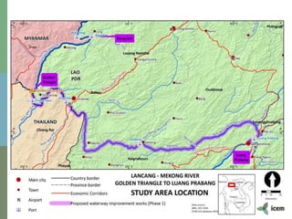
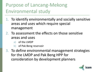
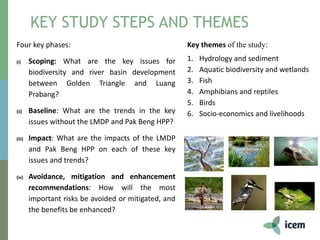
Final Workshop: 10 December 2018, MRC, Vientiane
Jeremy Carew-Reid
Environmental Study of the
Lancang-Mekong Development Plan
Introduction to the Project and Assessment
Methodology
Workshop
Morning
• Intro to the study and methodology (this presentation)
• Baseline assessment findings
• Plenary questions and discussion
Afternoon
• Impact assessment findings
• Plenary questions and discussion
• Mitigation strategies
• Plenary questions and discussion
• Panel questions and discussion
• Implementation of the Mekong River PA Network – Plenary
discussion
1. The Lancang-Mekong Cooperation
Mechanism
• The LMCM launched in November 2015,
• Six country collaborative agreement - China, Myanmar,
Laos, Thailand, Cambodia, and Vietnam
• Covers five priority areas: interconnectivity (transport,
power, communications), production capacity, cross-
border economic cooperation, water resources and
cooperation on agriculture and poverty reduction.
• Much broader than other Mekong agreements, such as
the GMS, which has the same membership and MRC
agreement
• Potential linkages with AIIB - the Chinese Asian
Infrastructure Investment Bank launched Jan 2016
2. Uncertainties over the LMCM
• Implications for
 the MRC
 the GMS arrangement
 for ADB and WB (linkage with AIIB)
 for the US Lower Mekong Initiative (LMI) (launched in
2009)
• Not founded on sustainability principles –
arrangements for member countries to assess
sustainability implications of LMCM development
initiatives uncertain
• Opportunities
4. LMDP preparation and
endorsement
• ‘Agreement on Commercial Navigation on Lancang-Mekong River’
between China, Lao PDR, Thailand, Myanmar- led to waterway
improvement works and port construction in Chiang Saen (Thailand) -
2000
• The draft LMDP presented to the Joint Committee on Coordination of
Commercial Navigation on the Lancang-Mekong River (JCCCN) by the
Department of Transport of Yunnan Province and Tianjin Research
Institute for Water Transport Engineering in February 2015
• MRC informal donor meeting called for action on assessing cumulative
impacts of the plan in March 2015
• MRC ‘Master Plan for Waterborne Transport’ recommended an SEA of the
LMDP and was supported by all Member Countries in November 2015
• The JCCCN gave conditional approval of the Master Plan in February 2016
3. Lancang-Mekong Development
Plan Phase 1- key ingredients
• Development of four cargo ports in study area at
Chiang Khong in Thailand and Houay Xay, Pak Beng and
Luang Prabang in Laos
• Removal of 146 rapids, rocky outcrops and shoals (from
Yunnan to Luang Prabang) to allow navigation for up to
500DWT vessels
• The construction of four emergency response and
rescue ships and 1199 aids to navigation
• Promotes increased shipping, trade and passenger
transport from Yunnan province to Luang Prabang
• Linked to other bilateral aid support from China to Laos
• 23 MRC surveyed ‘dangerous areas’ in study area – likely targets under the LMDP
• 4 ports to be developed under the LMDP in study area – Chiang Khong, Huay Xai,
Pak Beng and Luang Prabang
PAK BENG HPP – PROJECT DETAILS
8
• Concrete run-of-river dam 64m high (47m from river bed) x 900m long
• 912 MW
• Located 14km upstream of Pak Beng town
• 97km long reservoir
• Additional water level at dam approx. 25m
• Navigation lock for 500t boats
• Fish passage cement canal 1.6 km long, 10 m bottom width
PAK BENG HPP – PROJECT DETAILS
LANCANG MEKONG ENVIRONMENTAL STUDY: PURPOSE
10
 A site specific study focussing on biodiversity (378km river reach)
 Part of the MRC Council Study and funded by CEPF
 Two development scenarios (i) the navigation plan and (ii) the navigation plan
& Pak Beng
 If developments were to proceed what management responses are required
Purpose of Lancang-Mekong
Environmental study
1. To identify environmentally and socially sensitive
areas and uses which require special
management
2. To assessment the effects on those sensitive
areas and uses
a) of the LMDP
b) of Pak Beng reservoir
3. To define environmental management strategies
for the LMDP and Pak Beng HPP for
consideration by development planners
KEY STUDY STEPS
13
2016 2017 2018
MRC
International
Conference
Four key phases:
(i) Scoping: What are the key issues for
biodiversity and river basin development
between Golden Triangle and Luang
Prabang?
(ii) Baseline: What are the trends in the key
issues without the LMDP and Pak Beng HPP?
(iii) Impact: What are the impacts of the LMDP
and Pak Beng HPP on each of these key
issues and trends?
(iv) Avoidance, mitigation and enhancement
recommendations: How will the most
important risks be avoided or mitigated, and
the benefits be enhanced?
KEY STUDY STEPS AND THEMES
Key themes of the study:
1. Hydrology and sediment
2. Aquatic biodiversity and wetlands
3. Fish
4. Amphibians and reptiles
5. Birds
6. Socio-economics and livelihoods
Title Team Member
1. Ecologist and Environment Assessment Specialist/Team Leader Jeremy Carew-Red
2. Aquatic Biodiversity and Wetlands Specialist Peter-John-Meynell
3. International Fish Specialist Eric Baran
4. Lao PDR Fish Specialist Oudom Phonekhampheng
5. Thailand Fish Specialist Jutagate Tuantong
6. International Amphibian and Reptiles Specialist Bryan Stuart
7. Lao PDR Amphibian and Reptiles Specialist Somphouthone Phimmachak
8. Turtles Specialist Tim McCormack
9. Bird Specialist Will Duckworth
10. Navigation Safeguards/Transport Impact Assessment Specialist Rory Hunter
11. Hydrologist and Sediment Specialist Simon Tilleard
12. Hydrographic Surveying Specialist Paul Simcock
13. Waterway Design Specialist Jacques Dezeure
14. Economist Daniel Gilfillan
15. GIS Analyst Mai Ky Vinh
Consultations on the study
• 2016 Greater Mekong Forum on Water, Food and
Energy to present initial findings
– Workshop participants were drawn from Thai government
agencies, non-governmental organisations (NGOs) and civil
society, international organisations and universities and
academics.
• 2018 MRC International Conference: 2-3 April, Siem
Reap, Cambodia
• May 2018 at MRC Secretariat to advise on draft
recommendations
• 2018 Greater Mekong Forum on Water, Food and
Energy to present overview and results
• This event
Baseline Assessment Method
1. Biodiversity trend analysis
2. Socio-economic assessment
3. ‘From space’ assessment
4. ‘Swim Under’ assessment
5. Stakeholder consultation
6. Rapid integrated field
assessment
Impact Assessment Method
The impact assessment adopted an approach to include all possible
impacts.
Three study zones
ZONE 1 – GOLDEN TRIANGLE TO THAI-LAO
BORDER (98km) Habitats identified in survey – tributaries/deltas, vegetated islands,
rapids, rocky outcrops, sandbanks and shoals, off main channel
wetlands, deep pools
Whole Zone 1 =
KBA (birds and
fish)
-4 MRC surveyed
dangerous areas
likely targeted for
clearing under the
LMDP
-Construction of
the Houay Xay
and Chiang Khong
ports
ZONE 2 – THAI-LAO BORDER TO PAK BENG
(94km)
Whole Zone 2 =
KBA (birds and
fish)
-7 MRC surveyed
dangerous areas
But….
-Reservoir of Pak
Beng HPP
-No ports planned
ZONE 3 – PAK BENG TO
LUANG PRABANG (176km)
Part Zone 3
down to no. 14
rapid =
KBA (birds and
fish)
-12 MRC surveyed
dangerous areas
-Construction of
Pak Beng and
Luang Prabang
ports
-D/S impacts of
Pak Beng HPP
Mitigation Approach
Key steps included:
• Identifying areas where understanding needs to be improved
• Outlining measures for environmental and social management plans on
construction and operational impacts
• Defining areas requiring special conservation management and roles and
responsibilities
• Outlining how rights of vulnerable groups can be taken into account
• Laying groundwork for environmental and social management and
monitoring plans
THANK YOU

Presentation 1: Intro and Methodology

  • 1.
    Final Workshop: 10December 2018, MRC, Vientiane Jeremy Carew-Reid Environmental Study of the Lancang-Mekong Development Plan Introduction to the Project and Assessment Methodology
  • 2.
    Workshop Morning • Intro tothe study and methodology (this presentation) • Baseline assessment findings • Plenary questions and discussion Afternoon • Impact assessment findings • Plenary questions and discussion • Mitigation strategies • Plenary questions and discussion • Panel questions and discussion • Implementation of the Mekong River PA Network – Plenary discussion
  • 3.
    1. The Lancang-MekongCooperation Mechanism • The LMCM launched in November 2015, • Six country collaborative agreement - China, Myanmar, Laos, Thailand, Cambodia, and Vietnam • Covers five priority areas: interconnectivity (transport, power, communications), production capacity, cross- border economic cooperation, water resources and cooperation on agriculture and poverty reduction. • Much broader than other Mekong agreements, such as the GMS, which has the same membership and MRC agreement • Potential linkages with AIIB - the Chinese Asian Infrastructure Investment Bank launched Jan 2016
  • 4.
    2. Uncertainties overthe LMCM • Implications for  the MRC  the GMS arrangement  for ADB and WB (linkage with AIIB)  for the US Lower Mekong Initiative (LMI) (launched in 2009) • Not founded on sustainability principles – arrangements for member countries to assess sustainability implications of LMCM development initiatives uncertain • Opportunities
  • 5.
    4. LMDP preparationand endorsement • ‘Agreement on Commercial Navigation on Lancang-Mekong River’ between China, Lao PDR, Thailand, Myanmar- led to waterway improvement works and port construction in Chiang Saen (Thailand) - 2000 • The draft LMDP presented to the Joint Committee on Coordination of Commercial Navigation on the Lancang-Mekong River (JCCCN) by the Department of Transport of Yunnan Province and Tianjin Research Institute for Water Transport Engineering in February 2015 • MRC informal donor meeting called for action on assessing cumulative impacts of the plan in March 2015 • MRC ‘Master Plan for Waterborne Transport’ recommended an SEA of the LMDP and was supported by all Member Countries in November 2015 • The JCCCN gave conditional approval of the Master Plan in February 2016
  • 6.
    3. Lancang-Mekong Development PlanPhase 1- key ingredients • Development of four cargo ports in study area at Chiang Khong in Thailand and Houay Xay, Pak Beng and Luang Prabang in Laos • Removal of 146 rapids, rocky outcrops and shoals (from Yunnan to Luang Prabang) to allow navigation for up to 500DWT vessels • The construction of four emergency response and rescue ships and 1199 aids to navigation • Promotes increased shipping, trade and passenger transport from Yunnan province to Luang Prabang • Linked to other bilateral aid support from China to Laos
  • 7.
    • 23 MRCsurveyed ‘dangerous areas’ in study area – likely targets under the LMDP • 4 ports to be developed under the LMDP in study area – Chiang Khong, Huay Xai, Pak Beng and Luang Prabang
  • 8.
    PAK BENG HPP– PROJECT DETAILS 8 • Concrete run-of-river dam 64m high (47m from river bed) x 900m long • 912 MW • Located 14km upstream of Pak Beng town • 97km long reservoir • Additional water level at dam approx. 25m • Navigation lock for 500t boats • Fish passage cement canal 1.6 km long, 10 m bottom width
  • 9.
    PAK BENG HPP– PROJECT DETAILS
  • 10.
    LANCANG MEKONG ENVIRONMENTALSTUDY: PURPOSE 10  A site specific study focussing on biodiversity (378km river reach)  Part of the MRC Council Study and funded by CEPF  Two development scenarios (i) the navigation plan and (ii) the navigation plan & Pak Beng  If developments were to proceed what management responses are required
  • 12.
    Purpose of Lancang-Mekong Environmentalstudy 1. To identify environmentally and socially sensitive areas and uses which require special management 2. To assessment the effects on those sensitive areas and uses a) of the LMDP b) of Pak Beng reservoir 3. To define environmental management strategies for the LMDP and Pak Beng HPP for consideration by development planners
  • 13.
    KEY STUDY STEPS 13 20162017 2018 MRC International Conference
  • 14.
    Four key phases: (i)Scoping: What are the key issues for biodiversity and river basin development between Golden Triangle and Luang Prabang? (ii) Baseline: What are the trends in the key issues without the LMDP and Pak Beng HPP? (iii) Impact: What are the impacts of the LMDP and Pak Beng HPP on each of these key issues and trends? (iv) Avoidance, mitigation and enhancement recommendations: How will the most important risks be avoided or mitigated, and the benefits be enhanced? KEY STUDY STEPS AND THEMES Key themes of the study: 1. Hydrology and sediment 2. Aquatic biodiversity and wetlands 3. Fish 4. Amphibians and reptiles 5. Birds 6. Socio-economics and livelihoods
  • 15.
    Title Team Member 1.Ecologist and Environment Assessment Specialist/Team Leader Jeremy Carew-Red 2. Aquatic Biodiversity and Wetlands Specialist Peter-John-Meynell 3. International Fish Specialist Eric Baran 4. Lao PDR Fish Specialist Oudom Phonekhampheng 5. Thailand Fish Specialist Jutagate Tuantong 6. International Amphibian and Reptiles Specialist Bryan Stuart 7. Lao PDR Amphibian and Reptiles Specialist Somphouthone Phimmachak 8. Turtles Specialist Tim McCormack 9. Bird Specialist Will Duckworth 10. Navigation Safeguards/Transport Impact Assessment Specialist Rory Hunter 11. Hydrologist and Sediment Specialist Simon Tilleard 12. Hydrographic Surveying Specialist Paul Simcock 13. Waterway Design Specialist Jacques Dezeure 14. Economist Daniel Gilfillan 15. GIS Analyst Mai Ky Vinh
  • 16.
    Consultations on thestudy • 2016 Greater Mekong Forum on Water, Food and Energy to present initial findings – Workshop participants were drawn from Thai government agencies, non-governmental organisations (NGOs) and civil society, international organisations and universities and academics. • 2018 MRC International Conference: 2-3 April, Siem Reap, Cambodia • May 2018 at MRC Secretariat to advise on draft recommendations • 2018 Greater Mekong Forum on Water, Food and Energy to present overview and results • This event
  • 17.
    Baseline Assessment Method 1.Biodiversity trend analysis 2. Socio-economic assessment 3. ‘From space’ assessment 4. ‘Swim Under’ assessment 5. Stakeholder consultation 6. Rapid integrated field assessment
  • 18.
    Impact Assessment Method Theimpact assessment adopted an approach to include all possible impacts.
  • 19.
  • 20.
    ZONE 1 –GOLDEN TRIANGLE TO THAI-LAO BORDER (98km) Habitats identified in survey – tributaries/deltas, vegetated islands, rapids, rocky outcrops, sandbanks and shoals, off main channel wetlands, deep pools Whole Zone 1 = KBA (birds and fish) -4 MRC surveyed dangerous areas likely targeted for clearing under the LMDP -Construction of the Houay Xay and Chiang Khong ports
  • 21.
    ZONE 2 –THAI-LAO BORDER TO PAK BENG (94km) Whole Zone 2 = KBA (birds and fish) -7 MRC surveyed dangerous areas But…. -Reservoir of Pak Beng HPP -No ports planned
  • 22.
    ZONE 3 –PAK BENG TO LUANG PRABANG (176km) Part Zone 3 down to no. 14 rapid = KBA (birds and fish) -12 MRC surveyed dangerous areas -Construction of Pak Beng and Luang Prabang ports -D/S impacts of Pak Beng HPP
  • 23.
    Mitigation Approach Key stepsincluded: • Identifying areas where understanding needs to be improved • Outlining measures for environmental and social management plans on construction and operational impacts • Defining areas requiring special conservation management and roles and responsibilities • Outlining how rights of vulnerable groups can be taken into account • Laying groundwork for environmental and social management and monitoring plans
  • 24.

Editor's Notes

  • #20 Zone 1 – Golden triangle to the Thai-Lao border – (approx. 98km) – 3 dangerous areas Zone 2 – From the Thai-Lao border to Pak Beng Dam – (approx. 94km) – 7 dangerous areas; dam = 62 m, reservoir = 97 km long approx. Zone 3 – Pak Beng Dam downstream to Luang Prabang (approx. 176km) – 12 dangerous areas
  • #21 Key characteristics: More developed, particularly along the Thai side Broader and sandier river with more sand island terraces Fewer rocky outcrops and dangerous areas 3 deep pools and 3 very deep pools
  • #22 Key characteristics: Narrower, straighter and rockier channel Steep terrain with perpendicular valleys creating many tributaries Less developed with significant forest cover More dangerous areas 8 deep pools, no very deep pools
  • #23 Key characteristics: Channel still mainly narrow and rocky Many dangerous areas High number of deep and very deep pools - 7 very deep pools; 12 deep pools Parallel valleys Significant number of tributaries River widens and development increases closer to Luang Prabang