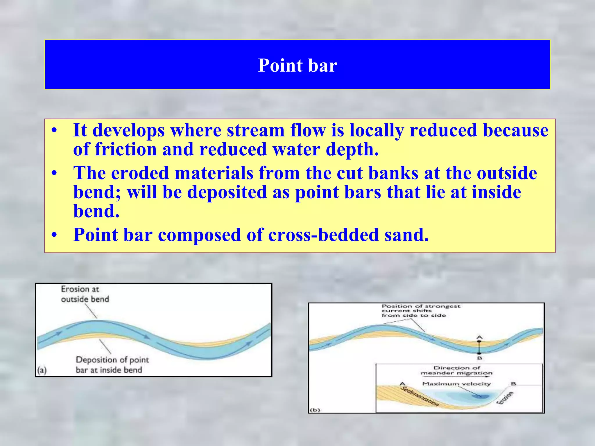
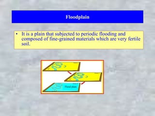
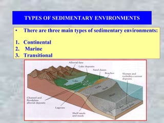
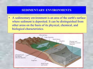
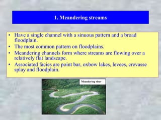
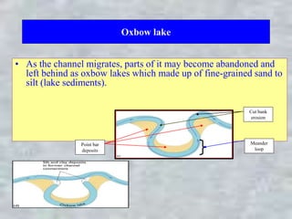
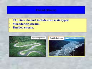
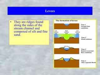
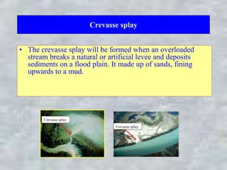
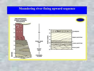
Point bar
• It develops where stream flow is locally reduced because
of friction and reduced water depth.
• The eroded materials from the cut banks at the outside
bend; will be deposited as point bars that lie at inside
bend.
• Point bar composed of cross-bedded sand.
Floodplain
• It is a plain that subjected to periodic flooding and
composed of fine-grained materials which are very fertile
soil.
Flood plain
CONTINENTAL ENVIRONMENTS
• Continental environments are those environments which
are present on the continents and include:
1. Fluvial (Rivers)
2. Lacustrine (Lakes)
3. Paludal (Swamps)
4. Glacial
5. Desert
TYPES OF SEDIMENTARY ENVIRONMENTS
• There are three main types of sedimentary environments:
1. Continental
2. Marine
3. Transitional
SEDIMENTARY ENVIRONMENTS
• A sedimentary environment is an area of the earth's surface
where sediment is deposited. It can be distinguished from
other areas on the basis of its physical, chemical, and
biological characteristics.
1. Meandering streams
• Have a single channel with a sinuous pattern and a broad
floodplain.
• The most common pattern on floodplains.
• Meandering channels form where streams are flowing over a
relatively flat landscape.
• Associated facies are point bar, oxbow lakes, levees, crevasse
splay and floodplain.
Meandering river
Oxbow lake
• As the channel migrates, parts of it may become abandoned and
left behind as oxbow lakes which made up of fine-grained sand to
silt (lake sediments).
Point bar
deposits
Cut bank
erosion
Meander
loop
Fluvial (Rivers)
• The river channel includes two main types:
• Meandering stream.
• Braided stream.
Meandering stream Braided stream
Levees
• They are ridges found
along the sides of the
stream channel and
composed of silt and fine
sand.
Crevasse splay
• The crevasse splay will be formed when an overloaded
stream breaks a natural or artificial levee and deposits
sediments on a flood plain. It made up of sands, fining
upwards to a mud.
Crevasse splay
Crevasse splay
Meandering river fining upward sequence
Sand dunes
• They are the most common aeolian landforms; their
geometry and resulting sedimentary structures depend
primarily on sediment supply and prevailing wind
direction.
• Eolian sand sheets develop when sediment supply is
limited and are characterized by planar stratification.
• Vegetation can contribute to dune formation under such
circumstances.
The Continental Shelf (Continental Platform)
– The continental shelves are commonly covered by terrigenous sediments, in
addition to non-clastic sediments such as carbonates, phosphates.
– Terrigenous sediments usually become increasingly fine with distance from the
shoreline whereas, sand is limited to shallow, wave-agitated waters, while silt
and clays are deposited in quieter, deep water far offshore.
– The carbonates of the continental shelf (carbonate factory) are rich in algae,
larger foraminfera etc..
– These shelf sediments accumulate at an average rate of 30 cm/1000 years, this
rate is much faster than that for deep-sea pelagic sediments.
The continental slope and continental rise
– They are located seaward of the continental shelf and may reach a depth of
4000 m.
– The continental slope is the steep (5- 25o) part at the edge of the continent.
– The continental slope passes seaward into the continental rise, which has a
more gradual slope.
– The continental rise is the site of deposition of thick accumulations of
sediment, much of which is in submarine fans, deposited by turbidity currents.
– Submarine fans are essentially turbidites dumps most typically at the mouths of
the submarine canyons that feed them.
Delta
– A delta forms where a river transporting significant quantities of sediment
enters a receiving basin such as ocean or other body of water.
– Name from the Greek letter ‘∆’, from the shape of the Nile Delta.
Delta
– Delta is subdivided into the delta plain, delta front and prodelta:
1. The delta plain
comprises a flat area dominated by alluvial deposition. The resulting
vertical deposits include alluvial channel fills, overbank muds and the
fine-grained sediment infill of lakes.
2. The delta front
is located at the distal edge of the delta plain; sediments are deposited in
mouth bars as the rivers emerge into the sea.
3. The prodelta
is most distal part of the delta whereas the finest grained sediments are
deposited.

Point bar.ppt

  • 1.
    Point bar • Itdevelops where stream flow is locally reduced because of friction and reduced water depth. • The eroded materials from the cut banks at the outside bend; will be deposited as point bars that lie at inside bend. • Point bar composed of cross-bedded sand.
  • 2.
    Floodplain • It isa plain that subjected to periodic flooding and composed of fine-grained materials which are very fertile soil. Flood plain
  • 3.
    CONTINENTAL ENVIRONMENTS • Continentalenvironments are those environments which are present on the continents and include: 1. Fluvial (Rivers) 2. Lacustrine (Lakes) 3. Paludal (Swamps) 4. Glacial 5. Desert
  • 4.
    TYPES OF SEDIMENTARYENVIRONMENTS • There are three main types of sedimentary environments: 1. Continental 2. Marine 3. Transitional
  • 5.
    SEDIMENTARY ENVIRONMENTS • Asedimentary environment is an area of the earth's surface where sediment is deposited. It can be distinguished from other areas on the basis of its physical, chemical, and biological characteristics.
  • 6.
    1. Meandering streams •Have a single channel with a sinuous pattern and a broad floodplain. • The most common pattern on floodplains. • Meandering channels form where streams are flowing over a relatively flat landscape. • Associated facies are point bar, oxbow lakes, levees, crevasse splay and floodplain. Meandering river
  • 7.
    Oxbow lake • Asthe channel migrates, parts of it may become abandoned and left behind as oxbow lakes which made up of fine-grained sand to silt (lake sediments). Point bar deposits Cut bank erosion Meander loop
  • 8.
    Fluvial (Rivers) • Theriver channel includes two main types: • Meandering stream. • Braided stream. Meandering stream Braided stream
  • 9.
    Levees • They areridges found along the sides of the stream channel and composed of silt and fine sand.
  • 10.
    Crevasse splay • Thecrevasse splay will be formed when an overloaded stream breaks a natural or artificial levee and deposits sediments on a flood plain. It made up of sands, fining upwards to a mud. Crevasse splay Crevasse splay
  • 11.
    Meandering river finingupward sequence
  • 12.
    Sand dunes • Theyare the most common aeolian landforms; their geometry and resulting sedimentary structures depend primarily on sediment supply and prevailing wind direction. • Eolian sand sheets develop when sediment supply is limited and are characterized by planar stratification. • Vegetation can contribute to dune formation under such circumstances.
  • 13.
    The Continental Shelf(Continental Platform) – The continental shelves are commonly covered by terrigenous sediments, in addition to non-clastic sediments such as carbonates, phosphates. – Terrigenous sediments usually become increasingly fine with distance from the shoreline whereas, sand is limited to shallow, wave-agitated waters, while silt and clays are deposited in quieter, deep water far offshore. – The carbonates of the continental shelf (carbonate factory) are rich in algae, larger foraminfera etc.. – These shelf sediments accumulate at an average rate of 30 cm/1000 years, this rate is much faster than that for deep-sea pelagic sediments.
  • 14.
    The continental slopeand continental rise – They are located seaward of the continental shelf and may reach a depth of 4000 m. – The continental slope is the steep (5- 25o) part at the edge of the continent. – The continental slope passes seaward into the continental rise, which has a more gradual slope. – The continental rise is the site of deposition of thick accumulations of sediment, much of which is in submarine fans, deposited by turbidity currents. – Submarine fans are essentially turbidites dumps most typically at the mouths of the submarine canyons that feed them.
  • 15.
    Delta – A deltaforms where a river transporting significant quantities of sediment enters a receiving basin such as ocean or other body of water. – Name from the Greek letter ‘∆’, from the shape of the Nile Delta.
  • 16.
    Delta – Delta issubdivided into the delta plain, delta front and prodelta: 1. The delta plain comprises a flat area dominated by alluvial deposition. The resulting vertical deposits include alluvial channel fills, overbank muds and the fine-grained sediment infill of lakes. 2. The delta front is located at the distal edge of the delta plain; sediments are deposited in mouth bars as the rivers emerge into the sea. 3. The prodelta is most distal part of the delta whereas the finest grained sediments are deposited.