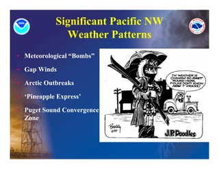
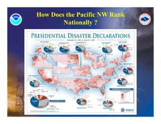
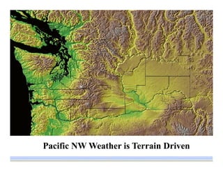
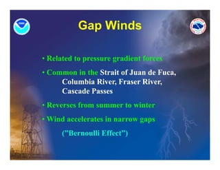
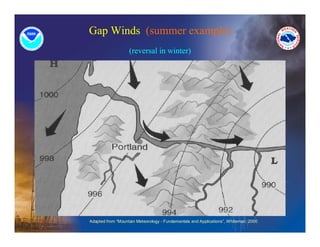
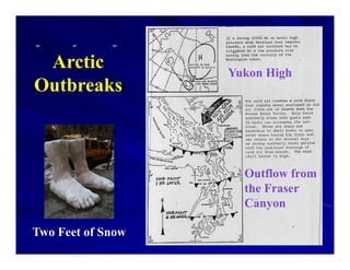
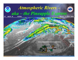
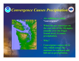
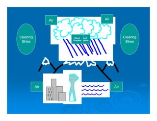
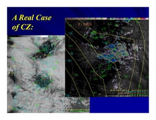
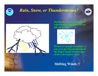
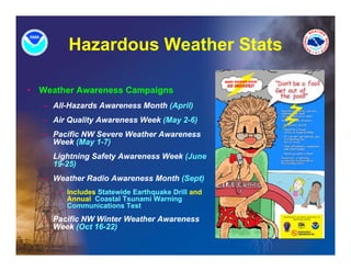
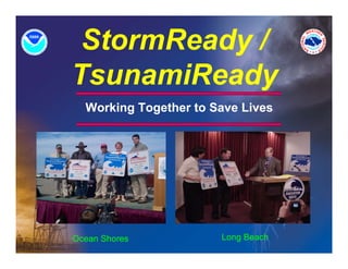
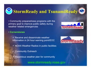
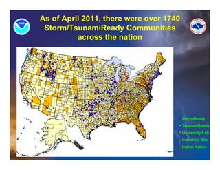
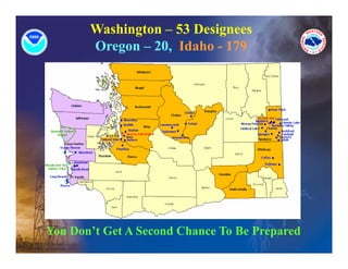
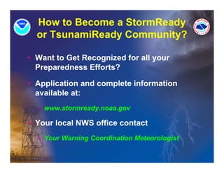
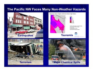
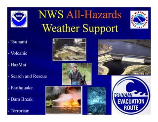
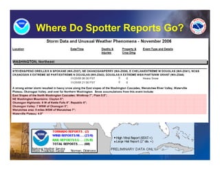
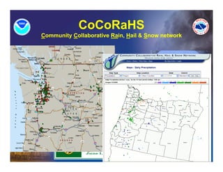
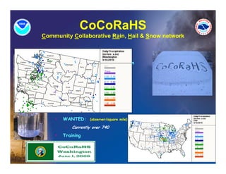
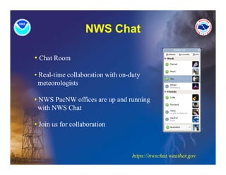
Partners In Weather
   Preparedness
        Advanced Session

 An Extension of the Basic Session


            Ted Buehner

 Warning Coordination Meteorologist

      National Weather Service

          Seattle/Tacoma
Pacific NW NWS Warning
            Coordination Meteorologists
            C di ti M t         l it
Seattle       Ted Buehner          206-526-6095 x223
              ted.buehner@noaa.gov
                db h @

Portland      Tyree Wilde            503-326-2340 x223
              tyree.wilde@noaa.gov
              tyree wilde@noaa gov

Spokane       Anthony Cavallucci     509-244-0110 x223
              anthony.cavallucci@noaa.gov

Pendleton     Dennis Hull            541-276-7832 x223
              dennis.hull@noaa.gov
                         @     g

Medford       Ryan Sandler          541-773-1067 x223
              ryan.sandler@noaa.gov

Boise         Robert Diaz            208-334-9860 x223
              robert.diaz@noaa.gov
National Weather Service
           Mission
         (Serving America Since 1870)

Provide Weather, Hydrologic, and Climate
Forecasts and Warnings for the United
                         g
States, its Territories, Adjacent Waters
and Ocean Areas, for the Protection of Life
and Property and Enhancement of the
National Economy.


We are Partners with a Common Mission
Outline
• Significant Pacific NW Weather Patterns

• Storm Surveys

• Area Hazardous Weather Stats

• StormReady / TsunamiReady Communities

• NWS All-Hazards Weather Support

• What’s New In NWS Products and Services
  What s

• Address Your Questions
Significant Pacific NW
              Weather Patterns
              W th P tt
• Meteorological “Bombs”

• Gap Winds

• Arctic Outbreaks

• ‘Pi
  ‘Pineapple Express’
          l E       ’

• Puget Sound Convergence
  Zone
  Zone
How Does the Pacific NW Rank
        Nationally ?
Pacific NW Weather is Terrain Driven
Topography
                    vs


Annual
Precipitation
Pacific NW
Wind Storms
       or
 “Meteorological
    Bombs”
Columbus Day Storm: Oct 12, 1962


http://www.wrh.noaa.gov/sew/WindstormBro.pdf
Dec 2006
Gap Winds
             p

• Related to pressure gradient forces
• Common in the Strait of Juan de Fuca,
     Columbia River, Fraser River,
     Cascade Passes
• Reverses from summer to winter
• Wi d accelerates in narrow gaps
  Wind     l t i
      (”Bernoulli Effect”)
Gap Winds (summer example)
                   (reversal in winter)


Adapted from “Mountain Meteorology - Fundamentals and Applications”, Whiteman, 2000
Arctic            Yukon High
Outbreaks


                     Outflow from
                     the Fraser
                     th F
                     Canyon

Two Feet of Snow
Atmospheric Rivers –
aka – the Pineapple Express
           .........
Characteristics of
          Pacific NW Flooding
   Extended periods of heavy rain combined with
high freezing levels.
   Orographic forcing over terrain usually plays
a major role in enhancing rainfall amounts.
   Low elevation snowmelt (below ~3,500 feet)
can be an important factor.
                      factor
   Typically higher mountain snowpack does not
contribute to runoff
              runoff.
   Spring snowpack thaw is only a serious flood
threat east of the Cascades.
   Most floods occur between November and
February.
Puget Sound Convergence Zone
  g               g
Ingredients

      1. Winds ith
      1 Wi d with a westerly
                       t l
         component.


      2. A barrier. (In our case, the
         Olympic Mountains.)
           y p                )


      3. Moisture.
      3 Moisture
What happens next?

• If the air is “blocked”
  and cannot travel over
  the mountains, it must
      mountains
  find an alternate route.
• What is the most probable
  alternate route for the air?

• AROUND the Olympic
  Mountains on both sides.
Convergence Causes Precipitation
                • Air colliding is called
                  “convergence”
                • When the air converges on
                                        g
                  the east side of the Olympics
                  (usually over the Puget
                  Sound area), it causes
                              ),
                  precipitation.
                • Why?
                • Convergence causes air to
                  rise, which causes the
                  moisture to condense and
                      it     t     d         d
                  fall out as precipitation.
Air                     Air


Clearing                Cloud Cloud
                        Cl d Cl d                    Clearing
                       Droplets
                              Droplets
 Skies                                                Skies


           Air                                 Air
A Real Case
of CZ:
Rain, Snow, or Thunderstorms?

               •   During the winter, if the air is
                   cold enough, precipitation can
                   fall out as snow!


               •   If there is enough instability we
                   can even get thunderstorms in
                   the Puget Sound area because
                   of the convergence zone!


                   Shifting Winds !!
Storm Surveys
                      y


• What Are They?

• When Are They
  Done?

• Local Emergency
  Manager’s
  Participation
  P ti i ti


                    I-90 Pileup – Feb 2007
Storm Surveys
                   y

                • What Are They?
                  – Document significant
                    weather events

                  – Go into our
                    climatological history

                  – Records
                     • Short term – Local
                       Short-term
                       Storm Reports

                     • Long-term - Recorded
Nov 06 Floods          in M thl StormData
                       i Monthly St    D t
Storm Surveys
                           y

• When Are They Done?
  – Follow severe convective weather events
     • Examples – tornadoes, severe thunderstorms

     • Vancouver tornado – Jan 2008

  – Can follow significant ‘long-fused’ events
     • Example – widespread major flooding

     • Early Dec 2007 storm
Storm Surveys


• Local Emergency Manager’s Participation
  – C
    Convective Weather Events
     • Asked to join the on-site survey of damage
     • Media often covers the survey party

  – Significant Long-Fuse Events
     • Usually conducted in your office following the event
     • Assesses NWS products and services throughout the
       event
Storm Surveys
• StormData
  – Monthly report submitted by all NWS Forecast Offices
     • Submitted 3 Months Following
     • Your Input Needed Depending on the Event
  – Includes:
     • Convective Weather Events
     • Long-Fused Weather Events
     • Fatalities, Injuries, Property Damage, Synopsis of Event
  – National Climatic Data Center (NCDC)
     • Publication – Monthly StormData
     • Available on Line at:
         – http://www5.ncdc.noaa.gov/pubs/publications.html
Enhanced Fujita Scale (EF)
                    Effective Feb 1, 2007
         FUJITA SCALE                            EF SCALE
       Fastest 1/4-mile   3 Second Gust             3 Second Gust
F#                                        EF #
           (mph)              (mph)                     (mph)

0           40-72             45-78        0            65-85

1          73-112            79-117        1           86-110

2          113-157           118-161       2           111-135

3          158-207          162-209        3          136-165

4          208-260          210-261        4          166-200

5          261-318          262-317        5          Over 200
Recent example: Sep ‘09 Enumclaw tornado – EF1
Hazardous Weather Stats

• Presidentially Declared Weather-Related
  Disasters

• Weather Statistics for Washington
Hazardous Weather Stats

• Presidentially Declared Weather-Related
  Disasters
  – #1 – Flooding ( ~50%)

  – #2 – Wi d Storm / Wi t /I Storms
         Wind St      Winter/Ice St

  – #4 – Wildfires

  – #5 – Landslides
Hazardous Weather Stats

• Fatalities
  – #1 - Heat
  – #2 - Avalanche
  – #3 - Wi d t
         Windstorms
  – #4 - Winter/Ice Storms
  – #5 - Floods
  – #6 - Landslides
Hazardous Weather Stats

• Weather Statistics for Washington
   – Short-fused Convective Events
      • Thunderstorms
          – Produce
             » Lightning
             » Hail
             » H
               Heavy P
                     Precipitation > Flash Floods
                         i it ti     Fl h Fl d
             » Downbursts
             » Tornadoes
Hazardous Weather Stats
•   Weather Statistics for
    Washington
    – Short-fused Convective
      Events
        • Thunderstorms
            – Lightning
                » 1 fatality about
                  every 5 years
                » Several injuries
                  each year
                » Avg 10-20
                  thunderstorms /
                  year
                » Th public is
                  The bli i
                  NOT
                  thunderstorm
                  proficient
Hazardous Weather Stats
• Weather Statistics for Washington
   – Short-fused Convective Events
      • Thunderstorms
          – Heavy Precipitation / Flash Floods
              » East of the Cascades concern
              » Flash Flood prone areas
              » Heppner, Ore Flash Flood
              » June 14, 1903
                     14
              » Second deadliest flash flood in American history
              » 247 fatalities, washed away Heppner and Ione
Hazardous Weather Stats
•   Weather Statistics for Washington
     – Short-fused Convective Events
         • Tornadoes – Average between 1 or 2 / year
             – O
               Occur anytime of year, primarily during transition
                        ti     f        i   il d i     t    iti
               seasons of spring and fall
             – Most quite weak – EF0 or EF1
             – Three reported F3s in our history since 1950
             – Apr 5, 1972 – Vancouver tornado
                  » Plowed thru grocery store, bowling house,
                    school
                  » Killed 6, injured 200+
                  » Led nation in tornado deaths that year
Hazardous Weather Stats
•   Weather Statistics for
    Washington
    – Long-fused Events
        • Heat
        • Cold
        • Avalanche
        • Winter Storms / Ice Storms
        • Flooding
        • Landslides
        • Wildfires
        • Coastal Flooding / Storm Surge
        • Dense Fog
        • Drought
        • Blowing Dust
Hazardous Weather Stats
• Weather Statistics for Washington
   – Long-fused Events
      • Heat
         – #1 Weather-related killer in the U.S. and the World
         – Over 1500 excess deaths from heat annually in the U.S.
           alone
         – More than all other weather-related fatalities combined
         – Heart Attacks, Strokes, Respiratory IIlnesses, Heat
           Stroke/Stress
         – Most Vulnerable
               » Elderly
               » Very Young
               » Those Left in Vehicles
Hazardous Weather Stats

•   Weather Statistics for
    Washington
    – Long-fused Events
      Long fused                     Chicago, Illinois:
                                           g
        • Heat (#1 in
                                     July 1995 Daily Mortality
          Washington)                          500
        • Seattle area alone – 645
                                               400
          excess deaths 1975-1999
            – Avg 27 per year                  300
                                     D eaths
              above normal             e

              mortality rate                   200

                                               100

                                                 0
                                                     1   5   9   13    17   21   25   29
                                                                      Day
Hazardous Weather Stats

•   Weather Statistics for
    Washington
    – Long-fused Events
      Long fused
        • Avalanche
            – #2 Weather-related
              killer in Washington
            – Avg 3 fatalities per
              year since mid
              1990s
Hazardous Weather Stats
                        •   Weather Statistics for
                            Washington
                            – Long-fused Events
                                • Wind Storms
                                    – #3 Weather-related killer in
                                      Washington
                                    – Average two fatalities per
                                      year
                                    – Several injuries per year
                                    – Usual Cause - Falling
                                                          g
                                      Trees or Limbs
                                    – Hanakkah Eve Wind Storm
                                      of 2006
Power Crew Working On
  Downed Power Lines                    » 15 fatalities (4 direct,
                                          11 indirect)
Hazardous Weather Stats
•   Weather Statistics for
    Washington
    – Long-fused Events
        • Flooding
            – No loss of life from
              1999-2005
            – Nov 2006 (2)
            – Dec 2007 (2)
            – Usual Causes
                                      Nov 2006 Floods – Cowlitz River
                » Driving across     Photos Courtesy of Lewis County DEM
                  flooded
                  roadways
                » Trying to cross
                  on foot
Hazardous Weather Stats

•   Weather Statistics for
    Washington
    – Long-fused Events
      Long fused
        • Landslides, Wildfires,
          Dense Fog
        • Winter Storms / Ice
          Storms, Blowing Dust
            – Have all caused
              fatalities i th
              f t liti in the
              past
            – Property Damage
Property Damage: Severe
      W th 1950-2006
      Weather 1950-

Total dollar amount of property damage is expressed in
millions of dollars

Data was grouped into decades

Five events were covered: windstorms, thunderstorms,
tornadoes, snow & ice, and flooding

Data is completely missing for the period between 1950-
                                                  1950-
1955
Fatalities: Severe Weather from
                 1950-
                 1950-2006
45
40
35
30
                                           Windstorms
                                           Wi d t
25
                                           Thunderstorms
20                                         Tornadoes
15                                         Snow & Ice
10                                         Flooding
 5
 0
     1950- 1960- 1970- 1980- 1990- 2000-
     1959 1969 1979 1989 1999 2006
Injuries: Severe Weather from
                  1950-
                  1950-2006
350

300

250

200                                         Windstorms
                                            Thunderstorms
150                                         Tornadoes
100                                         Snow & Ice
                                            Flooding
 50

  0
      1950- 1960- 1970- 1980- 1990- 2000-
      1959 1969 1979 1989 1999 2006
Property Damage: Severe Weather
           1950-
           1950-2006
350
300
250
                                            Windstorms
200
                                            Thunderstorms
150                                         Tornadoes
100                                         Snow & Ice
 50                                         Flooding

  0
      1950- 1960- 1970- 1980- 1990- 2000-
      1959 1969 1979 1989 1999 2006
2006
The Distribution of Washington Tornados, 1950 -1994.
                 0
                                    1         11
                                    0        11
                  22            1        1         1
                                        1
                 011 0                       2 11
                  1                     0     00 0
                                     2 1 30 1 0 1
              0 0             0           0 22
                 0
                13
                0
                                            0
       0   1 10
    0 0 1 00 0
               00
                       0
                              0     0
                                     10        1 0
     0    20                    00 1      1
                            2    0        0 2 1
    0 0 00
         1                                0
           00                    0 0 0 20
           1
            10
             3
Tornadoes Western Washington 1954-2006

            10
             9
             8
      ncy


             7
Frequen


             6
             5
             4
             3
             2
             1
             0
                      y


                             ri l
                     ry


                                    ay


                                                                    r
                                           ne


                                                   ly


                                                                    r
                                                                  st
                    ch


                                                                   r
                                                                  er

                                                                 be
                                                                 be


                                                                 be
                  ar


                                                 Ju

                                                                gu
                           Ap
                 ua


                                                               ob
                                    M

                                         Ju
                 ar
                nu


                                                              em
                                                             em


                                                             em
                                                            Au
               br

              M


                                                             ct
             Ja

            Fe


                                                           pt


                                                          ov
                                                           O


                                                          ec
                                                        Se


                                                        N

                                                        D
                                                Month


                 Frequency of tornadoes each month of
                                the year
T o r n a d o W e s t e r n W a s h in g t o n T im e
                                   1 9 5 4 -2 0 0 6

            10

             8
 requency


             6                                                      A M H o u rs
             4                                                      P M H o u rs
Fr


             2

             0
                  1   2   3   4   5    6   7     8   9   10 11 12
                                      H o u rs


                 Frequency of tornadoes throughout
                       each hour of the day
Hazardous Weather Stats

•   Weather Awareness Campaigns
    – All-Hazards Awareness Month (April)
    – Air Q alit Awareness Week (Ma 2 6)
          Quality A areness     (May 2-6)
    – Pacific NW Severe Weather Awareness
      Week (May 1-7)
    – Lightning Safety Awareness Week (June
      19-25)
    – Weather Radio Awareness Month (Sept)
        • Includes Statewide Earthquake Drill and
          Annual Coastal Tsunami Warning
          Communications Test
    – Pacific NW Winter Weather Awareness
      Week (Oct 16-22)
StormReady /
 Sto   eady
TsunamiReady
  Working Together to Save Lives


Ocean Shores           Long Beach
Is Your Community Ready?
StormReady and TsunamiReady
• Community preparedness programs with the
primary goal to improve public safety during
weather related emergencies

• Cornerstones

    Receive and disseminate weather
   information in 24 hour warning point/EOC

    NOAA Weather Radios in public facilities

    Community Outreach

    Hazardous weather plan for community

                  www.stormready.noaa.gov
Recognition
As of April 2011, there were over 1740
 Storm/TsunamiReady Communities
                       y
          across the nation


                                     • StormReady
                                     • TsunamiReady
                                     • University/Lab
                                     • I d t i l Site
                                       Industrial Sit
                                     • Indian Nation
Washington – 53 Designees
       Oregon – 20, Idaho - 179


You Don’t Get A Second Chance To Be Prepared
How to Become a StormReady
  or T
     TsunamiReady Community?
           iR d C        it ?

• Want to Get Recognized for all your
  Preparedness Efforts?

• Application and complete information
  available at:
  – www.stormready.noaa.gov

• Your local NWS office contact
  – Your Warning Coordination Meteorologist
               g                       g
The Pacific NW Faces Many Non-Weather Hazards
                          Non-


     Earthquakes               Tsunamis


       Terrorism          Major Chemical Spills
NWS All-Hazards
               Weather Support
- Tsunami

- Volcanic

- HazMat

- Search and Rescue

- Earthquake

- Dam Break

- Terrorism
Working Together When
               ‘It’ Happens
•   Weather Support
    – Phone, Radio

    – On-Line

    – On-Site

•   Emergency Message
    Dissemination

•   NOAA’s Hazmat Response
    and Restoration Office
    – Oil Spill

    – Chemical Spill

    – Coastal Contamination
National Response Framework
Emergency Support Functions (ESFs)
          NOAA/NWS Participation
 •   ESF 1 – Transportation
 •   ESF 2 – Communications
 •   ESF 3 – Public Works and Engineering
 •   ESF 4 – Firefighting
 •   ESF 5 – Emergency Management
 •   ESF 7 – Resource Support
 •   ESF 9 – Urban Search and Rescue
 •   ESF 10 – Oil and Hazardous Materials Response
 •   ESF 11 – Agriculture and Natural Resources
 •   ESF 12 – Energy
 •   ESF 13 – Public Safety and Security
 •   ESF 14 – Long-term Community Recovery and Mitigation
              Long term
 •   ESF 15 – External Affairs
All-
                       All-Hazards
                      Weather Support
                      W h S


New Carrissa                                      Selendang AYU
   1999                                                2005


                        - Weather Data
Missoula Derailment
       1996
                        -FForecasts
                                  t         Hurricane Katrina
                                                  2005
                        - Incident Mets
                        - On-Site or from
                            NWS Office
                        - Exercises
NWS Fire Weather / All-Hazards
                   All-
24/7 Phone Contacts (Unlisted)

   Forecaster Support and
   Coordination
                   Seattle -   206-526-6088

                    Portland - 503-326-2420

                    Spokane - 509-244-5031

                    Pendleton - 541-276-8134
NWS Seattle Amateur
              Radio W k t ti
              R di Workstation
•   UHF / VHF
    – K7MMI Repeater System,
      147.20
•   Seattle 800 MHz, King,
                   ,    g,
    Pierce, Snohomish
    counties
•   State CemNet
•   Packet, APRS
•   HF
•   Skywarn Recognition Day
•   Exercises
Available NWS Services –
            On-site Support
•   Incident Meteorologist (IMET)
                      g (       )
    – Local Expertise
    – Able to work independent of local NWS office
    – Provide weather input to response team
•   Trained
    – ICS
    – HAZMAT Response
    – Media
•   Resources
    – 4X4 response vehicle
    – Laptop with portable two-way satellite dish
    – Local weather observation equipment
www.weather.gov/seattle

www.weather.gov/spokane
www weather gov/spokane

www.weather.gov/pendleton

www.weather.gov/portland


  Nationally -
www.weather.gov
              g
Spot Forecasts
           p
                    Your Local NWS
                         Web Site
                         Click the
                    Fire Weather Link


- Wildfire
- HAZMAT
- Search & Rescue
Spot Forecasts
 p
Spot Forecasts
     SAR Spots          HAZMAT Spots
25                 45

                   40

20
                   35

                   30
15
                   25

                   20
10
                   15

                   10
5

                   5

0                  0


       SAR Spots           HAZMET Spots
HYSPLIT
(Hybrid Single Particle Lagrangian Integrated Trajectory Model)
        Single-Particle


                                               For Events
                                               Larger Than
                                               10 k
                                                  km
Working Together When
            ‘It’ Happens

• Weather Support
  – Phone, Radio

  – On-Line

  – On-Site

• Emergency Message
  Dissemination
NWS Warning                                 Government
        Product                                    Agencies


                        NOAA Port                    NOAA
                                                    Weather
                                                      Wire
                                          EMWIN
       Internet
                    Private     Associated
                    Vendors        Press             ACCESS

NWR / EAS

                              Media


  General                     Emergency           Multiple
   Public                       Mgmt               Paths
NWS is an All-Hazards
           All-
Weather Support Resource
 In Summary – Working Together When
             ‘It’ Happens
 • Site-Specific Weather Support
    • Phone
    • Radio
    • On-Line
    • On-Site
 • Emergency Message Dissemination
    • NOAA Weather Radio
    • Emergency Alert System (EAS)
    • Text Message to Newswires/Media
    • E-Warn, iNWS, NWSChat
    • Social Media
What s
                 What’s New?
•   Social Impacts of Weather
•   FLARE
•   Area Forecast Discussions
•   Weather Spotters
•   CoCoRaHS
•   NWSChat
•   E-Warn
•   iNWS
•   NOAA Weather Radio
•   HazCollect
•   A Few More
Social Impacts of Weather
• What are the impacts of:
   • High Wind
   • Floods
   • Winter Storms
   • Heat
   • Landslides and more

• Improving decision support for community leaders
    • High Impact Weather Events (e.g. – Howard Hanson Dam)
    • Planning in Advance
    • Public Safety
    • Protecting / Mitigating Impacts to Property
    • Maintaining / Enhancing Commerce

• Proactive steps
     • Weather Outlooks / Watches / Warnings / Statements
     • On-line Weather Briefings
       On line
     • Forecast Discussions - 4 times per day
     • Is there more? Your input desired
Virtual Weather Briefings

• Virtual and Interactive on-line
weather briefings

• Decision Support Services

• Audio provided by a toll-free conf
          p       y
call line

• Conducted prior to and through
anticipated significant weather
events

• Notification of briefings via email
                         g

• Secure control over desktop
sharing
Fully Localized Atmospheric Research Environment
                           FLARE
                Desktop Weather Display S t
                D kt W th Di l System


- 5 separate panels
     - Observational data
     - Local zone forecasts
          - Icons
          - Ticker
     - Looping images
     - Warning display
- Customize to your needs
- Great for Kiosks, EOCs,
desktops, etc
                    Available NOW!

       Application   http://www.wrh.noaa.gov/wrh/ssd/flare.msi
       Documentation http://www.wrh.noaa.gov/wrh/ssd/index-flare.html
NWS Seattle to You

• NOAA W th R di
       Weather Radio
  • 22 stations serving
    Washington
  • All H
    All-Hazards Warning
             d W      i
    System
  • Warning Alarm
  • Emerg Alert System (EAS)

• On the Web
  • weather.gov/seattle/
  • Nationwide – weather.gov
This is a clickable
   map that gives you
   a point forecast


       www.weather.gov/
       seattle


        Nationwide -
  Click here for the
        weather.gov
- Zone forecast or the
- Forecast Discussion
Area Forecast Discussion (AFD)
AREA FORECAST DISCUSSION
NATIONAL WEATHER SERVICE SEATTLE WA
300 AM PDT THU AUG 14 2008

.SYNOPSIS...A STRONG UPPER RIDGE AND LOW LEVEL OFFSHORE FLOW WILL BRING SUNNY WEATHER
THROUGH SATURDAY WITH RECORD OR NEAR RECORD HIGH TEMPERATURES UNSTABLE AIR WILL LEAD TO A
                                                    TEMPERATURES.
THREAT OF THUNDERSTORMS SATURDAY. A TRANSITION TO A COOLER REGIME WILL GET UNDERWAY SUNDAY....AS
ONSHORE FLOW PUSHES COOLER MARINE AIR INLAND BY MONDAY. AN UPPER TROUGH WILL PRODUCE A
CHANCE OF SHOWERS BY WEDNESDAY.

&&

.SHORT TERM...AS EXPECTED A STRONG UPPER RIDGE HAS DEVELOPED ALONG THE WEST COAST OF NORTH
AMERICA IN RESPONSE TO A DEEPENING TROUGH OFFSHORE ALONG 150W (image). THE LOW LEVEL FLOW HAS
TURNED WEAKLY OFFSHORE AS A THERMALLY INDUCED SURFACE TROUGH EXTENDS NORTHWARD
FROM NORTHERN CALIFORNIA ALONG THE PACIFIC NORTHWEST COAST. OF COURSE THIS IS THE CLASSIC
SCENARIO FOR HOT SUMMER WEATHER IN WESTERN WASHINGTON...AND IT WILL PRODUCE GENERALLY SUNNY
SKIES AND RECORD OR NEAR RECORD HIGH TEMPERATURES FOR THE NEXT THREE DAYS.

THE HOT SPELL WILL REALLY GET UNDERWAY TODAY AS 500 MB HEIGHTS CLIMB ABOVE 590 DAM AND THE
THERMAL TROUGH EXTENDS ACROSS VANCOUVER ISLAND (image). WEAK NORTHERLY FLOW WILL KEEP
TEMPERATURES FROM REACHING THEIR FULL POTENTIAL OVER MUCH OF WESTERN WASHINGTON...BUT SOME
OF THE RECORD HIGHS FOR TODAY ARE ANOMALOUSLY LOW AND THEY SHOULD BE TIED OR BROKEN. FOR
EXAMPLE THE RECORD AT SEATAC IS ONLY 88.

   These are hypertext links to images
FRIDAY WILL BE WARMER YET AS THE UPPER RIDGE SHIFTS ONLY SLIGHTLY EASTWARD...AND THE SURFACE
THERMAL TROUGH REMAINS ANCHORED ALONG THE COAST THE LOWER ATMOSPHERE WILL REALLY WARM UP
                                              COAST.
   that h
   th t show the weather pattern in the
                   th          th          tt         i th
BETWEEN TODAY AND FRIDAY WITH 850 MB TEMPERATURES CLIMBING INTO THE LOW 20S (image).
   Enhanced AFD
SATURDAY SHOULD BE THE WARMEST DAY IN THE SERIES...AT LEAST FOR THE WESTERN WASHINGTON INTERIOR.
THE UPPER RIDGE WILL BE TO OUR EAST AND UPPER HEIGHTS WILL FALL SLIGHTLY...BUT THE LOWER
ATMOSPHERE WILL CONTINUE TO WARM SLIGHTLY AND...MOST IMPORTANT...THE THERMAL TROUGH WILL SHIFT
Sample Enhanced AFD Images
Spotters are so important!
• They help the NWS by reporting on hazardous
  weather in their area

• Their reports lead to better forecast and
  warning accuracy

• Their reports help verify and accompany radar
  and satellite data

• Bottom line: They provide ground truth!
  “The
  “Th eyes and ears of the NWS”
               d       f th

• Training scheduled year round
How are Spotter Reports Used?
         p        p

• NWS Warning Program
  – “Ground Truth”
  – Reinforce current warning messages
  – Basis and Verification of weather warnings and
    advisories
     d i   i

• Transmitted to…..
  – Media (TV, radio, newspapers, Internet)
  – Local Emergency Management Staff
Where Do Spotter Reports Go?
          p        p
CoCoRaHS
Community Collaborative Rain, Hail & Snow network


    •   Volunteers Report Precipitation
        On-Line. Community and Citizen
        Involvement!
         –   Rain , Hail , Snow

    •   Daily & Event Driven Reports
    •   Interactive Web site:
        www.cocorahs.org
    •   Adds Greater Precipitation
        Report Density Across WA/OR
    •   WANTED:        (observer/square mile)

    •   Training
CoCoRaHS
Community Collaborative Rain, Hail & Snow network


    •   Volunteers Report Precipitation
        On-Line. Community and Citizen
        Involvement!
         –   Rain , Hail , Snow

    •   Daily & Event Driven Reports
    •   Interactive Web site:
        www.cocorahs.org
    •   Adds Greater Precipitation
        Report Density Across WA
    •   WANTED:        (observer/square mile)

         –   Currently over 740
    •   Training
NWS Chat

• Chat Room

• Real-time collaboration with on duty
  Real time                    on-duty
  meteorologists

• NWS P NW offices are up and running
        PacNW ffi           d     i
  with NWS Chat

• Join us for collaboration


                                   https://nwschat.weather.gov
NWS Chat
• Chat Room             • NWS BOT
• Multiple Chat Rooms   • Hyperlink to any warning product
Bonus Feature – NWS BOT
• NWS BOT
• Hyperlink to any warning product
New! NWS Chat Live
  nwschat.weather.gov/live
      h t    th      /li
NWS Chat
How do I get started?
• Request account for NWS
Partners at:
https://nwschat.weather.gov/create.php
     login (e.g., EM-John.doe)
     password

• Download and install Pidgin
IM client
     http://www pidgin im/
      http://www.pidgin.im/
    Use pidgin v2.7.11
     Also an Internet version

• Start Chatting
E-Warn
•   Automatic Email Notification (PC, cell phone, PDA)
•   Set up for single or multiple counties
•   Just need your desired email address and type of messages you
    wish to receive
•   To Register, contact your Warning Coordination Meteorologist
•NWS Mobile is an application th t will run on mobile devices
 NWS M bil          ppli ti that ill           m bil d i s
•Allows you to browse the following weather data using a map
interface:
    •NWS watches warnings, and advisories
           watches, warnings
    •Radar and satellite imagery
    •Observations
    •Forecasts
     Forecasts

         http://inws.wrh.noaa.gov
Easy as 1-2-3
area


county                         zipcode


         Multiple alert areas, even
         outside WA
Social Media

• Facebook
  – www.facebook.com/US.National.Weather.Service.gov

  – www.facebook.com/US.NationalWeatherService.Seattle.gov

• Twitter Storm Report
  – http://www.srh.noaa.gov/srh/twitter/twitter.php

• YouTube Channel
  – http://www.youtube.com/usnoaagov

• www.noaa.gov/socialmedia
NWS Products and Services
                Guide for Oregon and
                             g
                    Washington
•   Updated this Winter

•   On NWS Seattle Web Site

•   On NWS Portland Web Site

•   Offers:
    – NWS Products

    – NWS Dissemination
      System

    – Terminology

    – And much more!
On-Line Weather Educational
        Slide Sh
        Slid Shows

                •   Started in 2007
                         •   More being added

                •   Local Topics
                         •   Pacific NW Wind Storms
                         •   Puget Sound Convergence Zone
                         •   Pineapple Express
                         •   Heat Waves
                         •   Arctic Outbreaks
                         •   Lightning Safety

                •   Less Than 15 Min Long
                •   Great for Home, Work, Classroom
                •   weather.gov/seattle
                •   What Topics Do You Want ??
The COMET® Program
                            g

COMET founded as a Cooperative Program
in 1990 by NOAA NWS


A program within the University Corporation
for Atmospheric Research


In addition to NOAA, 8 other sponsoring
                              p       g
organizations


Offers free computer based distance learning
            computer-based
via the MetEd Website, for over 120,000
registered users world-wide
COMET® Resources

Offers dozens of education and training
modules via the International Multi-
Hazards Early Warning Systems site
on MetEd.


Designed for NMHS and Emergency
Management professions, as well as
     g
government decision makers and the
general public.


Many modules available in both English
and Spanish.


                                          http://www.meted.ucar.edu/hazwarnsys/index.php
The COMET® Program
Education and Training
 http://www.meted.ucar.edu/hazwarnsys/index.php
NWS Heat Health Watch/Warning
               System
               S stem
• Seattle Area’s Debuted Summer 2005

• Portland’s Debuted Summer of 2006

• Heat is a Killer – Even Here!
    • 1975-1999 – 645 excess deaths in Seattle area
    • Avg of 27 per year above normal mortality rate
        g        p y                          y
    • #1 weather-related killer
• System is Tailored for our Climate and Community

• Issued during Unseasonable Hot Spells if a Threat to Lives

• Education and Awareness Partnership with Area Health
   d    i     d                   hi i h           lh
   Community and Emergency Management Officials
NWS Products and Services
       Your Weather Support Partner
                                 Serving America
                                       g
                                   Since 1870

                                 Helping Protect
                                   Lives and
                                  Property and
                                   Enhancing
                                  Our Economy


     Ted Buehner
 Warning Coordination
    Meteorologist
NWS Seattle/Tacoma, Wa
Questions ??
Time to Surf a NWS
       Web Site !

What Do You Want to Cover?
- Interpret Radar?
- Interpret Satellite?
- Spotter Reports?
- Digital Forecasts/GIS?
- Historical Data?
- Others?

Partners in Weather Preparedness – Advanced

  • 2.
    Partners In Weather Preparedness Advanced Session An Extension of the Basic Session Ted Buehner Warning Coordination Meteorologist National Weather Service Seattle/Tacoma
  • 3.
    Pacific NW NWSWarning Coordination Meteorologists C di ti M t l it Seattle Ted Buehner 206-526-6095 x223 ted.buehner@noaa.gov db h @ Portland Tyree Wilde 503-326-2340 x223 tyree.wilde@noaa.gov tyree wilde@noaa gov Spokane Anthony Cavallucci 509-244-0110 x223 anthony.cavallucci@noaa.gov Pendleton Dennis Hull 541-276-7832 x223 dennis.hull@noaa.gov @ g Medford Ryan Sandler 541-773-1067 x223 ryan.sandler@noaa.gov Boise Robert Diaz 208-334-9860 x223 robert.diaz@noaa.gov
  • 4.
    National Weather Service Mission (Serving America Since 1870) Provide Weather, Hydrologic, and Climate Forecasts and Warnings for the United g States, its Territories, Adjacent Waters and Ocean Areas, for the Protection of Life and Property and Enhancement of the National Economy. We are Partners with a Common Mission
  • 5.
    Outline • Significant PacificNW Weather Patterns • Storm Surveys • Area Hazardous Weather Stats • StormReady / TsunamiReady Communities • NWS All-Hazards Weather Support • What’s New In NWS Products and Services What s • Address Your Questions
  • 6.
    Significant Pacific NW Weather Patterns W th P tt • Meteorological “Bombs” • Gap Winds • Arctic Outbreaks • ‘Pi ‘Pineapple Express’ l E ’ • Puget Sound Convergence Zone Zone
  • 7.
    How Does thePacific NW Rank Nationally ?
  • 8.
    Pacific NW Weatheris Terrain Driven
  • 9.
    Topography vs Annual Precipitation
  • 10.
    Pacific NW Wind Storms or “Meteorological Bombs”
  • 11.
    Columbus Day Storm:Oct 12, 1962 http://www.wrh.noaa.gov/sew/WindstormBro.pdf
  • 12.
  • 13.
    Gap Winds p • Related to pressure gradient forces • Common in the Strait of Juan de Fuca, Columbia River, Fraser River, Cascade Passes • Reverses from summer to winter • Wi d accelerates in narrow gaps Wind l t i (”Bernoulli Effect”)
  • 14.
    Gap Winds (summerexample) (reversal in winter) Adapted from “Mountain Meteorology - Fundamentals and Applications”, Whiteman, 2000
  • 15.
    Arctic Yukon High Outbreaks Outflow from the Fraser th F Canyon Two Feet of Snow
  • 16.
    Atmospheric Rivers – aka– the Pineapple Express .........
  • 17.
    Characteristics of Pacific NW Flooding Extended periods of heavy rain combined with high freezing levels. Orographic forcing over terrain usually plays a major role in enhancing rainfall amounts. Low elevation snowmelt (below ~3,500 feet) can be an important factor. factor Typically higher mountain snowpack does not contribute to runoff runoff. Spring snowpack thaw is only a serious flood threat east of the Cascades. Most floods occur between November and February.
  • 18.
  • 19.
    Ingredients 1. Winds ith 1 Wi d with a westerly t l component. 2. A barrier. (In our case, the Olympic Mountains.) y p ) 3. Moisture. 3 Moisture
  • 20.
    What happens next? •If the air is “blocked” and cannot travel over the mountains, it must mountains find an alternate route. • What is the most probable alternate route for the air? • AROUND the Olympic Mountains on both sides.
  • 21.
    Convergence Causes Precipitation • Air colliding is called “convergence” • When the air converges on g the east side of the Olympics (usually over the Puget Sound area), it causes ), precipitation. • Why? • Convergence causes air to rise, which causes the moisture to condense and it t d d fall out as precipitation.
  • 22.
    Air Air Clearing Cloud Cloud Cl d Cl d Clearing Droplets Droplets Skies Skies Air Air
  • 23.
  • 24.
    Rain, Snow, orThunderstorms? • During the winter, if the air is cold enough, precipitation can fall out as snow! • If there is enough instability we can even get thunderstorms in the Puget Sound area because of the convergence zone! Shifting Winds !!
  • 25.
    Storm Surveys y • What Are They? • When Are They Done? • Local Emergency Manager’s Participation P ti i ti I-90 Pileup – Feb 2007
  • 26.
    Storm Surveys y • What Are They? – Document significant weather events – Go into our climatological history – Records • Short term – Local Short-term Storm Reports • Long-term - Recorded Nov 06 Floods in M thl StormData i Monthly St D t
  • 27.
    Storm Surveys y • When Are They Done? – Follow severe convective weather events • Examples – tornadoes, severe thunderstorms • Vancouver tornado – Jan 2008 – Can follow significant ‘long-fused’ events • Example – widespread major flooding • Early Dec 2007 storm
  • 28.
    Storm Surveys • LocalEmergency Manager’s Participation – C Convective Weather Events • Asked to join the on-site survey of damage • Media often covers the survey party – Significant Long-Fuse Events • Usually conducted in your office following the event • Assesses NWS products and services throughout the event
  • 29.
    Storm Surveys • StormData – Monthly report submitted by all NWS Forecast Offices • Submitted 3 Months Following • Your Input Needed Depending on the Event – Includes: • Convective Weather Events • Long-Fused Weather Events • Fatalities, Injuries, Property Damage, Synopsis of Event – National Climatic Data Center (NCDC) • Publication – Monthly StormData • Available on Line at: – http://www5.ncdc.noaa.gov/pubs/publications.html
  • 30.
    Enhanced Fujita Scale(EF) Effective Feb 1, 2007 FUJITA SCALE EF SCALE Fastest 1/4-mile 3 Second Gust 3 Second Gust F# EF # (mph) (mph) (mph) 0 40-72 45-78 0 65-85 1 73-112 79-117 1 86-110 2 113-157 118-161 2 111-135 3 158-207 162-209 3 136-165 4 208-260 210-261 4 166-200 5 261-318 262-317 5 Over 200 Recent example: Sep ‘09 Enumclaw tornado – EF1
  • 31.
    Hazardous Weather Stats •Presidentially Declared Weather-Related Disasters • Weather Statistics for Washington
  • 32.
    Hazardous Weather Stats •Presidentially Declared Weather-Related Disasters – #1 – Flooding ( ~50%) – #2 – Wi d Storm / Wi t /I Storms Wind St Winter/Ice St – #4 – Wildfires – #5 – Landslides
  • 33.
    Hazardous Weather Stats •Fatalities – #1 - Heat – #2 - Avalanche – #3 - Wi d t Windstorms – #4 - Winter/Ice Storms – #5 - Floods – #6 - Landslides
  • 34.
    Hazardous Weather Stats •Weather Statistics for Washington – Short-fused Convective Events • Thunderstorms – Produce » Lightning » Hail » H Heavy P Precipitation > Flash Floods i it ti Fl h Fl d » Downbursts » Tornadoes
  • 35.
    Hazardous Weather Stats • Weather Statistics for Washington – Short-fused Convective Events • Thunderstorms – Lightning » 1 fatality about every 5 years » Several injuries each year » Avg 10-20 thunderstorms / year » Th public is The bli i NOT thunderstorm proficient
  • 36.
    Hazardous Weather Stats •Weather Statistics for Washington – Short-fused Convective Events • Thunderstorms – Heavy Precipitation / Flash Floods » East of the Cascades concern » Flash Flood prone areas » Heppner, Ore Flash Flood » June 14, 1903 14 » Second deadliest flash flood in American history » 247 fatalities, washed away Heppner and Ione
  • 37.
    Hazardous Weather Stats • Weather Statistics for Washington – Short-fused Convective Events • Tornadoes – Average between 1 or 2 / year – O Occur anytime of year, primarily during transition ti f i il d i t iti seasons of spring and fall – Most quite weak – EF0 or EF1 – Three reported F3s in our history since 1950 – Apr 5, 1972 – Vancouver tornado » Plowed thru grocery store, bowling house, school » Killed 6, injured 200+ » Led nation in tornado deaths that year
  • 38.
    Hazardous Weather Stats • Weather Statistics for Washington – Long-fused Events • Heat • Cold • Avalanche • Winter Storms / Ice Storms • Flooding • Landslides • Wildfires • Coastal Flooding / Storm Surge • Dense Fog • Drought • Blowing Dust
  • 39.
    Hazardous Weather Stats •Weather Statistics for Washington – Long-fused Events • Heat – #1 Weather-related killer in the U.S. and the World – Over 1500 excess deaths from heat annually in the U.S. alone – More than all other weather-related fatalities combined – Heart Attacks, Strokes, Respiratory IIlnesses, Heat Stroke/Stress – Most Vulnerable » Elderly » Very Young » Those Left in Vehicles
  • 40.
    Hazardous Weather Stats • Weather Statistics for Washington – Long-fused Events Long fused Chicago, Illinois: g • Heat (#1 in July 1995 Daily Mortality Washington) 500 • Seattle area alone – 645 400 excess deaths 1975-1999 – Avg 27 per year 300 D eaths above normal e mortality rate 200 100 0 1 5 9 13 17 21 25 29 Day
  • 41.
    Hazardous Weather Stats • Weather Statistics for Washington – Long-fused Events Long fused • Avalanche – #2 Weather-related killer in Washington – Avg 3 fatalities per year since mid 1990s
  • 42.
    Hazardous Weather Stats • Weather Statistics for Washington – Long-fused Events • Wind Storms – #3 Weather-related killer in Washington – Average two fatalities per year – Several injuries per year – Usual Cause - Falling g Trees or Limbs – Hanakkah Eve Wind Storm of 2006 Power Crew Working On Downed Power Lines » 15 fatalities (4 direct, 11 indirect)
  • 43.
    Hazardous Weather Stats • Weather Statistics for Washington – Long-fused Events • Flooding – No loss of life from 1999-2005 – Nov 2006 (2) – Dec 2007 (2) – Usual Causes Nov 2006 Floods – Cowlitz River » Driving across Photos Courtesy of Lewis County DEM flooded roadways » Trying to cross on foot
  • 44.
    Hazardous Weather Stats • Weather Statistics for Washington – Long-fused Events Long fused • Landslides, Wildfires, Dense Fog • Winter Storms / Ice Storms, Blowing Dust – Have all caused fatalities i th f t liti in the past – Property Damage
  • 45.
    Property Damage: Severe W th 1950-2006 Weather 1950- Total dollar amount of property damage is expressed in millions of dollars Data was grouped into decades Five events were covered: windstorms, thunderstorms, tornadoes, snow & ice, and flooding Data is completely missing for the period between 1950- 1950- 1955
  • 46.
    Fatalities: Severe Weatherfrom 1950- 1950-2006 45 40 35 30 Windstorms Wi d t 25 Thunderstorms 20 Tornadoes 15 Snow & Ice 10 Flooding 5 0 1950- 1960- 1970- 1980- 1990- 2000- 1959 1969 1979 1989 1999 2006
  • 47.
    Injuries: Severe Weatherfrom 1950- 1950-2006 350 300 250 200 Windstorms Thunderstorms 150 Tornadoes 100 Snow & Ice Flooding 50 0 1950- 1960- 1970- 1980- 1990- 2000- 1959 1969 1979 1989 1999 2006
  • 48.
    Property Damage: SevereWeather 1950- 1950-2006 350 300 250 Windstorms 200 Thunderstorms 150 Tornadoes 100 Snow & Ice 50 Flooding 0 1950- 1960- 1970- 1980- 1990- 2000- 1959 1969 1979 1989 1999 2006
  • 49.
    2006 The Distribution ofWashington Tornados, 1950 -1994. 0 1 11 0 11 22 1 1 1 1 011 0 2 11 1 0 00 0 2 1 30 1 0 1 0 0 0 0 22 0 13 0 0 0 1 10 0 0 1 00 0 00 0 0 0 10 1 0 0 20 00 1 1 2 0 0 2 1 0 0 00 1 0 00 0 0 0 20 1 10 3
  • 50.
    Tornadoes Western Washington1954-2006 10 9 8 ncy 7 Frequen 6 5 4 3 2 1 0 y ri l ry ay r ne ly r st ch r er be be be ar Ju gu Ap ua ob M Ju ar nu em em em Au br M ct Ja Fe pt ov O ec Se N D Month Frequency of tornadoes each month of the year
  • 51.
    T o rn a d o W e s t e r n W a s h in g t o n T im e 1 9 5 4 -2 0 0 6 10 8 requency 6 A M H o u rs 4 P M H o u rs Fr 2 0 1 2 3 4 5 6 7 8 9 10 11 12 H o u rs Frequency of tornadoes throughout each hour of the day
  • 52.
    Hazardous Weather Stats • Weather Awareness Campaigns – All-Hazards Awareness Month (April) – Air Q alit Awareness Week (Ma 2 6) Quality A areness (May 2-6) – Pacific NW Severe Weather Awareness Week (May 1-7) – Lightning Safety Awareness Week (June 19-25) – Weather Radio Awareness Month (Sept) • Includes Statewide Earthquake Drill and Annual Coastal Tsunami Warning Communications Test – Pacific NW Winter Weather Awareness Week (Oct 16-22)
  • 53.
    StormReady / Sto eady TsunamiReady Working Together to Save Lives Ocean Shores Long Beach
  • 54.
  • 55.
    StormReady and TsunamiReady •Community preparedness programs with the primary goal to improve public safety during weather related emergencies • Cornerstones  Receive and disseminate weather information in 24 hour warning point/EOC  NOAA Weather Radios in public facilities  Community Outreach  Hazardous weather plan for community www.stormready.noaa.gov
  • 56.
  • 57.
    As of April2011, there were over 1740 Storm/TsunamiReady Communities y across the nation • StormReady • TsunamiReady • University/Lab • I d t i l Site Industrial Sit • Indian Nation
  • 58.
    Washington – 53Designees Oregon – 20, Idaho - 179 You Don’t Get A Second Chance To Be Prepared
  • 59.
    How to Becomea StormReady or T TsunamiReady Community? iR d C it ? • Want to Get Recognized for all your Preparedness Efforts? • Application and complete information available at: – www.stormready.noaa.gov • Your local NWS office contact – Your Warning Coordination Meteorologist g g
  • 60.
    The Pacific NWFaces Many Non-Weather Hazards Non- Earthquakes Tsunamis Terrorism Major Chemical Spills
  • 61.
    NWS All-Hazards Weather Support - Tsunami - Volcanic - HazMat - Search and Rescue - Earthquake - Dam Break - Terrorism
  • 62.
    Working Together When ‘It’ Happens • Weather Support – Phone, Radio – On-Line – On-Site • Emergency Message Dissemination • NOAA’s Hazmat Response and Restoration Office – Oil Spill – Chemical Spill – Coastal Contamination
  • 63.
    National Response Framework EmergencySupport Functions (ESFs) NOAA/NWS Participation • ESF 1 – Transportation • ESF 2 – Communications • ESF 3 – Public Works and Engineering • ESF 4 – Firefighting • ESF 5 – Emergency Management • ESF 7 – Resource Support • ESF 9 – Urban Search and Rescue • ESF 10 – Oil and Hazardous Materials Response • ESF 11 – Agriculture and Natural Resources • ESF 12 – Energy • ESF 13 – Public Safety and Security • ESF 14 – Long-term Community Recovery and Mitigation Long term • ESF 15 – External Affairs
  • 64.
    All- All-Hazards Weather Support W h S New Carrissa Selendang AYU 1999 2005 - Weather Data Missoula Derailment 1996 -FForecasts t Hurricane Katrina 2005 - Incident Mets - On-Site or from NWS Office - Exercises
  • 65.
    NWS Fire Weather/ All-Hazards All- 24/7 Phone Contacts (Unlisted) Forecaster Support and Coordination Seattle - 206-526-6088 Portland - 503-326-2420 Spokane - 509-244-5031 Pendleton - 541-276-8134
  • 66.
    NWS Seattle Amateur Radio W k t ti R di Workstation • UHF / VHF – K7MMI Repeater System, 147.20 • Seattle 800 MHz, King, , g, Pierce, Snohomish counties • State CemNet • Packet, APRS • HF • Skywarn Recognition Day • Exercises
  • 67.
    Available NWS Services– On-site Support • Incident Meteorologist (IMET) g ( ) – Local Expertise – Able to work independent of local NWS office – Provide weather input to response team • Trained – ICS – HAZMAT Response – Media • Resources – 4X4 response vehicle – Laptop with portable two-way satellite dish – Local weather observation equipment
  • 68.
  • 69.
    Spot Forecasts p Your Local NWS Web Site Click the Fire Weather Link - Wildfire - HAZMAT - Search & Rescue
  • 70.
  • 71.
    Spot Forecasts SAR Spots HAZMAT Spots 25 45 40 20 35 30 15 25 20 10 15 10 5 5 0 0 SAR Spots HAZMET Spots
  • 72.
    HYSPLIT (Hybrid Single ParticleLagrangian Integrated Trajectory Model) Single-Particle For Events Larger Than 10 k km
  • 73.
    Working Together When ‘It’ Happens • Weather Support – Phone, Radio – On-Line – On-Site • Emergency Message Dissemination
  • 74.
    NWS Warning Government Product Agencies NOAA Port NOAA Weather Wire EMWIN Internet Private Associated Vendors Press ACCESS NWR / EAS Media General Emergency Multiple Public Mgmt Paths
  • 75.
    NWS is anAll-Hazards All- Weather Support Resource In Summary – Working Together When ‘It’ Happens • Site-Specific Weather Support • Phone • Radio • On-Line • On-Site • Emergency Message Dissemination • NOAA Weather Radio • Emergency Alert System (EAS) • Text Message to Newswires/Media • E-Warn, iNWS, NWSChat • Social Media
  • 76.
    What s What’s New? • Social Impacts of Weather • FLARE • Area Forecast Discussions • Weather Spotters • CoCoRaHS • NWSChat • E-Warn • iNWS • NOAA Weather Radio • HazCollect • A Few More
  • 77.
    Social Impacts ofWeather • What are the impacts of: • High Wind • Floods • Winter Storms • Heat • Landslides and more • Improving decision support for community leaders • High Impact Weather Events (e.g. – Howard Hanson Dam) • Planning in Advance • Public Safety • Protecting / Mitigating Impacts to Property • Maintaining / Enhancing Commerce • Proactive steps • Weather Outlooks / Watches / Warnings / Statements • On-line Weather Briefings On line • Forecast Discussions - 4 times per day • Is there more? Your input desired
  • 78.
    Virtual Weather Briefings •Virtual and Interactive on-line weather briefings • Decision Support Services • Audio provided by a toll-free conf p y call line • Conducted prior to and through anticipated significant weather events • Notification of briefings via email g • Secure control over desktop sharing
  • 79.
    Fully Localized AtmosphericResearch Environment FLARE Desktop Weather Display S t D kt W th Di l System - 5 separate panels - Observational data - Local zone forecasts - Icons - Ticker - Looping images - Warning display - Customize to your needs - Great for Kiosks, EOCs, desktops, etc Available NOW! Application http://www.wrh.noaa.gov/wrh/ssd/flare.msi Documentation http://www.wrh.noaa.gov/wrh/ssd/index-flare.html
  • 80.
    NWS Seattle toYou • NOAA W th R di Weather Radio • 22 stations serving Washington • All H All-Hazards Warning d W i System • Warning Alarm • Emerg Alert System (EAS) • On the Web • weather.gov/seattle/ • Nationwide – weather.gov
  • 81.
    This is aclickable map that gives you a point forecast www.weather.gov/ seattle Nationwide - Click here for the weather.gov - Zone forecast or the - Forecast Discussion
  • 82.
    Area Forecast Discussion(AFD) AREA FORECAST DISCUSSION NATIONAL WEATHER SERVICE SEATTLE WA 300 AM PDT THU AUG 14 2008 .SYNOPSIS...A STRONG UPPER RIDGE AND LOW LEVEL OFFSHORE FLOW WILL BRING SUNNY WEATHER THROUGH SATURDAY WITH RECORD OR NEAR RECORD HIGH TEMPERATURES UNSTABLE AIR WILL LEAD TO A TEMPERATURES. THREAT OF THUNDERSTORMS SATURDAY. A TRANSITION TO A COOLER REGIME WILL GET UNDERWAY SUNDAY....AS ONSHORE FLOW PUSHES COOLER MARINE AIR INLAND BY MONDAY. AN UPPER TROUGH WILL PRODUCE A CHANCE OF SHOWERS BY WEDNESDAY. && .SHORT TERM...AS EXPECTED A STRONG UPPER RIDGE HAS DEVELOPED ALONG THE WEST COAST OF NORTH AMERICA IN RESPONSE TO A DEEPENING TROUGH OFFSHORE ALONG 150W (image). THE LOW LEVEL FLOW HAS TURNED WEAKLY OFFSHORE AS A THERMALLY INDUCED SURFACE TROUGH EXTENDS NORTHWARD FROM NORTHERN CALIFORNIA ALONG THE PACIFIC NORTHWEST COAST. OF COURSE THIS IS THE CLASSIC SCENARIO FOR HOT SUMMER WEATHER IN WESTERN WASHINGTON...AND IT WILL PRODUCE GENERALLY SUNNY SKIES AND RECORD OR NEAR RECORD HIGH TEMPERATURES FOR THE NEXT THREE DAYS. THE HOT SPELL WILL REALLY GET UNDERWAY TODAY AS 500 MB HEIGHTS CLIMB ABOVE 590 DAM AND THE THERMAL TROUGH EXTENDS ACROSS VANCOUVER ISLAND (image). WEAK NORTHERLY FLOW WILL KEEP TEMPERATURES FROM REACHING THEIR FULL POTENTIAL OVER MUCH OF WESTERN WASHINGTON...BUT SOME OF THE RECORD HIGHS FOR TODAY ARE ANOMALOUSLY LOW AND THEY SHOULD BE TIED OR BROKEN. FOR EXAMPLE THE RECORD AT SEATAC IS ONLY 88. These are hypertext links to images FRIDAY WILL BE WARMER YET AS THE UPPER RIDGE SHIFTS ONLY SLIGHTLY EASTWARD...AND THE SURFACE THERMAL TROUGH REMAINS ANCHORED ALONG THE COAST THE LOWER ATMOSPHERE WILL REALLY WARM UP COAST. that h th t show the weather pattern in the th th tt i th BETWEEN TODAY AND FRIDAY WITH 850 MB TEMPERATURES CLIMBING INTO THE LOW 20S (image). Enhanced AFD SATURDAY SHOULD BE THE WARMEST DAY IN THE SERIES...AT LEAST FOR THE WESTERN WASHINGTON INTERIOR. THE UPPER RIDGE WILL BE TO OUR EAST AND UPPER HEIGHTS WILL FALL SLIGHTLY...BUT THE LOWER ATMOSPHERE WILL CONTINUE TO WARM SLIGHTLY AND...MOST IMPORTANT...THE THERMAL TROUGH WILL SHIFT
  • 83.
  • 84.
    Spotters are soimportant! • They help the NWS by reporting on hazardous weather in their area • Their reports lead to better forecast and warning accuracy • Their reports help verify and accompany radar and satellite data • Bottom line: They provide ground truth! “The “Th eyes and ears of the NWS” d f th • Training scheduled year round
  • 85.
    How are SpotterReports Used? p p • NWS Warning Program – “Ground Truth” – Reinforce current warning messages – Basis and Verification of weather warnings and advisories d i i • Transmitted to….. – Media (TV, radio, newspapers, Internet) – Local Emergency Management Staff
  • 86.
    Where Do SpotterReports Go? p p
  • 87.
    CoCoRaHS Community Collaborative Rain,Hail & Snow network • Volunteers Report Precipitation On-Line. Community and Citizen Involvement! – Rain , Hail , Snow • Daily & Event Driven Reports • Interactive Web site: www.cocorahs.org • Adds Greater Precipitation Report Density Across WA/OR • WANTED: (observer/square mile) • Training
  • 88.
    CoCoRaHS Community Collaborative Rain,Hail & Snow network • Volunteers Report Precipitation On-Line. Community and Citizen Involvement! – Rain , Hail , Snow • Daily & Event Driven Reports • Interactive Web site: www.cocorahs.org • Adds Greater Precipitation Report Density Across WA • WANTED: (observer/square mile) – Currently over 740 • Training
  • 89.
    NWS Chat • ChatRoom • Real-time collaboration with on duty Real time on-duty meteorologists • NWS P NW offices are up and running PacNW ffi d i with NWS Chat • Join us for collaboration https://nwschat.weather.gov
  • 90.
    NWS Chat • ChatRoom • NWS BOT • Multiple Chat Rooms • Hyperlink to any warning product
  • 91.
    Bonus Feature –NWS BOT • NWS BOT • Hyperlink to any warning product
  • 92.
    New! NWS ChatLive nwschat.weather.gov/live h t th /li
  • 93.
    NWS Chat How doI get started? • Request account for NWS Partners at: https://nwschat.weather.gov/create.php  login (e.g., EM-John.doe)  password • Download and install Pidgin IM client  http://www pidgin im/ http://www.pidgin.im/ Use pidgin v2.7.11  Also an Internet version • Start Chatting
  • 94.
    E-Warn • Automatic Email Notification (PC, cell phone, PDA) • Set up for single or multiple counties • Just need your desired email address and type of messages you wish to receive • To Register, contact your Warning Coordination Meteorologist
  • 95.
    •NWS Mobile isan application th t will run on mobile devices NWS M bil ppli ti that ill m bil d i s •Allows you to browse the following weather data using a map interface: •NWS watches warnings, and advisories watches, warnings •Radar and satellite imagery •Observations •Forecasts Forecasts http://inws.wrh.noaa.gov
  • 96.
  • 97.
    area county zipcode Multiple alert areas, even outside WA
  • 98.
    Social Media • Facebook – www.facebook.com/US.National.Weather.Service.gov – www.facebook.com/US.NationalWeatherService.Seattle.gov • Twitter Storm Report – http://www.srh.noaa.gov/srh/twitter/twitter.php • YouTube Channel – http://www.youtube.com/usnoaagov • www.noaa.gov/socialmedia
  • 99.
    NWS Products andServices Guide for Oregon and g Washington • Updated this Winter • On NWS Seattle Web Site • On NWS Portland Web Site • Offers: – NWS Products – NWS Dissemination System – Terminology – And much more!
  • 100.
    On-Line Weather Educational Slide Sh Slid Shows • Started in 2007 • More being added • Local Topics • Pacific NW Wind Storms • Puget Sound Convergence Zone • Pineapple Express • Heat Waves • Arctic Outbreaks • Lightning Safety • Less Than 15 Min Long • Great for Home, Work, Classroom • weather.gov/seattle • What Topics Do You Want ??
  • 101.
    The COMET® Program g COMET founded as a Cooperative Program in 1990 by NOAA NWS A program within the University Corporation for Atmospheric Research In addition to NOAA, 8 other sponsoring p g organizations Offers free computer based distance learning computer-based via the MetEd Website, for over 120,000 registered users world-wide
  • 102.
    COMET® Resources Offers dozensof education and training modules via the International Multi- Hazards Early Warning Systems site on MetEd. Designed for NMHS and Emergency Management professions, as well as g government decision makers and the general public. Many modules available in both English and Spanish. http://www.meted.ucar.edu/hazwarnsys/index.php
  • 103.
    The COMET® Program Educationand Training http://www.meted.ucar.edu/hazwarnsys/index.php
  • 104.
    NWS Heat HealthWatch/Warning System S stem • Seattle Area’s Debuted Summer 2005 • Portland’s Debuted Summer of 2006 • Heat is a Killer – Even Here! • 1975-1999 – 645 excess deaths in Seattle area • Avg of 27 per year above normal mortality rate g p y y • #1 weather-related killer • System is Tailored for our Climate and Community • Issued during Unseasonable Hot Spells if a Threat to Lives • Education and Awareness Partnership with Area Health d i d hi i h lh Community and Emergency Management Officials
  • 105.
    NWS Products andServices Your Weather Support Partner Serving America g Since 1870 Helping Protect Lives and Property and Enhancing Our Economy Ted Buehner Warning Coordination Meteorologist NWS Seattle/Tacoma, Wa
  • 106.
  • 107.
    Time to Surfa NWS Web Site ! What Do You Want to Cover? - Interpret Radar? - Interpret Satellite? - Spotter Reports? - Digital Forecasts/GIS? - Historical Data? - Others?