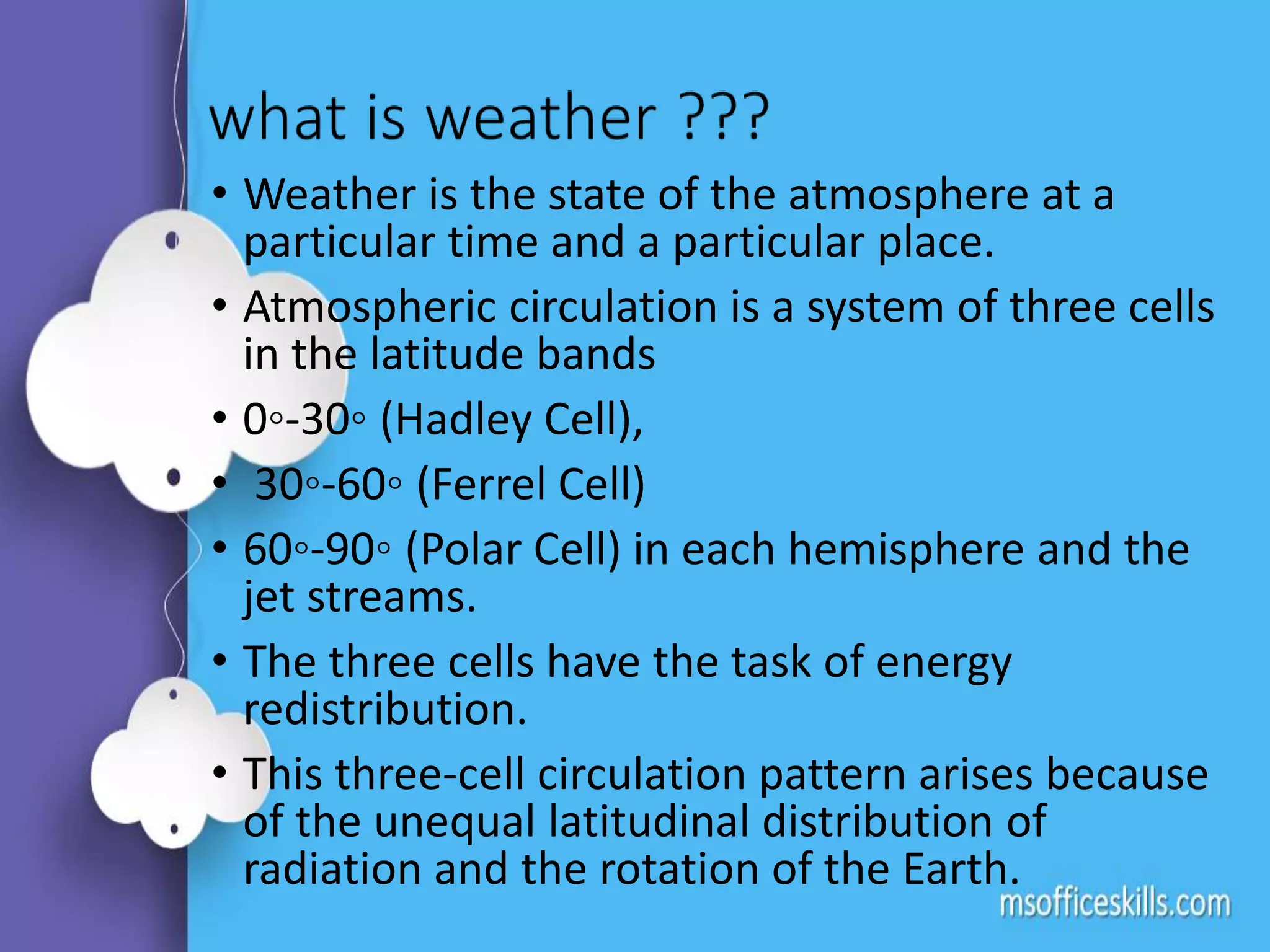
Weather cells and systems, jet streams,
climate change and its implications
Presented by
K. Divya,
Ph. D,
Genetics and
Plant Breeding
• Weather is the state of the atmosphere at a
particular time and a particular place.
• Atmospheric circulation is a system of three cells
in the latitude bands
• 0◦-30◦ (Hadley Cell),
• 30◦-60◦ (Ferrel Cell)
• 60◦-90◦ (Polar Cell) in each hemisphere and the
jet streams.
• The three cells have the task of energy
redistribution.
• This three-cell circulation pattern arises because
of the unequal latitudinal distribution of
radiation and the rotation of the Earth.
• Hadley cell –
• huge thunderstorms develop as the air rises and
condenses.
• Latent heat released during storms continues to drive the
Hadley cell.
• Zone of low pressure is formed at the equator: inter-
tropical convergence zone.
• High pressures at about 30◦: subtropical highs.
• As the surface air returns to the equator in the NH it will
flow NE to SW and SE to NW in the Southern Hemisphere.
• These are called the trade winds that converge in the
inter tropical convergence zone (ITCZ).
•Ferrel cell-
• is a thermally indirect cell because it is driven by the
motions of the cells on either side.
• Reality we observe upper level westerlies in midlatitudes.
• The reason is that at upper levels there is high pressure in
the equator (due to higher temperature) and lower
temperature at the poles.
• For this reason there is a pressure gradient from equator
to pole and the actual wind is deflected due to Coriolis so
this causes predominant westerlies at upper levels that
are stronger in the winter.
• For this reason the weather systems migrate from west to
east
•Polar Cell –
• Similar to the Hadley in that at about 60◦ there is rising
motion and movement towards the pole at upper levels
with westerly motion.
• subpolar low- storms and clouds develop.
• The air sinks at the poles producing the polar high and at
the surface there is deflection to cause polar easterlies as
the air moves from poles to the subpolar low.
• A polar front separates cold air coming from the poles
from milder air coming from midlatitudes, and the peaks
of precipitation in the mid-latitudes are primarily
produced by extra-tropical cyclones that develop along
this front.
Jet streams
• In the upper troposphere “rivers” of rapidly moving air
circle around the Earth.
• Jet streams are swiftly flowing air currents, thousands of
km long and a few hundred km wide, and only a few km
thick.
• There are two jet streams in the NH, one at about 30◦,
the subtropical jet and one at about 60◦ the polar jet.
• Both occur in the tropopause.
• They occur at the boundaries between areas of
temperature change.
• First discovered in the 1920s by Wasaburo Ooishi.
• Knowledge of the jet stream increased during World War
II while flying between Europe and North America.
• Jet streams cause air to rise, lowering the air
pressure at the Earth's surface.
• When surface pressures are low, the rising air can
form clouds, precipitation and storms.
Weather systems:
• Superimposed on the regular rhythms of the
atmosphere are more extreme events that threaten
lives, disrupt transportation systems, and cause
destruction
Weather systems….
Types:
• Air Masses
• Frontal Systems
• Mid-latitude Cyclones
• Thunderstorms
• Tornadoes
• Water spouts
• Hurricanes
Air masses
• large regions of the lower atmosphere with uniform
characteristics - originally defined by a source area.
• represent large regions (1,000s km2) of the lower
troposphere - with relatively uniform properties
(temperature, moisture content).
• There are 5 types of air masses
• cA - Continental Arctic/ Antarctic
• cP – Continental Polar
• cT – Continental Tropical
• mP – Maritime Polar
• mT – Maritime Tropical
Characters of different kinds of air masses
cA
continental
Arctic/ Antarctic
cP
continenetal
polar
cT
continental
tropical
mP
maritime polar
mT
maritime
tropical
 Forms at high
latitudes
around poles
 Extremely
cold, dry air
& produces
days of bone
chilling
temperature
 Cold dry but
without
extreme cold
temperatures
 High lake
effect snow
fall.
 Forms over
continental
interiors
 Brings
scorching
summers
 Decay as they
move east
absorbing
moisture
 Characterized
by cool moist
air
 Temp at
ocean surface
are lower
than on land
 So, mP are
warmer than
cP
 High temp,
humidity that
move inland
 Brings hot
summers
cP air masses causing lake effect snow.
Frontal systems
• Frontal systems form along the boundaries between colliding
air masses of contrasting properties.
• There are 3 types
1. Cold fronts
2. Warm fronts
3. Occluded fronts
How to identify a front on a surface weather map
• Sharp temperature changes over a relatively short distance
• Change in moisture content
• Rapid shifts in wind direction
• Pressure changes
• Clouds and precipitation patterns
• Cold, dense continental polar air replaces warm tropical air
• People experience decreasing temperature and humidity with increase in pressure
• Warm air rises over cold air
• Rapid cooling and condensation resulting in formation of cumulonimbus clouds and
heavy precipitation
• Rapidly advancing cold fronts are marked by growth of squall line of thunderclouds.
• Slope of ½ degree towards warm air masses
• Warm and humid winds are transported over a distance
• First there is formation of upper level cirrus and cirrostratus clouds (upto 12 hrs)
• Later formation of lower level nimbostratus clouds associated with precipitaton
• Precipitation remains for longer time than from cold fronts over extended areas as
warm fronts move slowly
• Temp & humidity rises and winds shift in direction from south to south west.
• a combination of warm and cold front
• juxtaposes two bodies of cold air; the warmer of the two masses is forced up and
over the other.
• Forcing the intervening warm air upward generating additional precipitation
• marked by the occurrence of nimbostratus clouds.
Mid-latitude cyclones
Synoptic scale low pressure
weather systems that occur in
the middle latitudes, connected
with fronts and horizontal
gradients in temperature and
dew point along anticyclones.
Capable of producing
 Cloudiness
 Mild showers
 heavy gales
 Thunderstorms.
Thunderstorms
Characterized by the presence of
lightening and its acoustic effect
on the earths atmosphere
known as thunder.
Congenial conditions to form:
• Moisture
• Unstable Air
• Upward drift
Weather phenomena
associated
Down burst of winds, Lightening
& Acoustic sounds, Hail storms,
Heavy precipitation & flash
floods
Tornadoes
• Tornadoes are narrow, funnel-
shaped spiraling wind that rotate at
speeds of up to 500 km/hr because
of extreme pressure gradients.
• Tornadoes are ranked from F0
(weakest) to F5 (strongest) using the
Fujita Intensity scale.
• Most tornadoes move to the east or
northeast at an average speed of
approximately 50 km/hr.
• Tornadoes are associated with
thunderstorms and develop in
association with mesocyclones
within the thunderstorm cell.
Water sprouts
• Usually occurs over warm tropical
ocean waters, waterspouts often
appears as a funnel-shaped cloud that
is descending from the stormy sky.
• As scientists define, a waterspout is a
rotating column of water that contains
an intense vortex.
• waterspouts are quite common and
rather non-destructive considering the
frequency of their occurrences.
• An average waterspout would be
around 50 meters in diameter and its
associated wind will move at an
average speed of about 50 miles an
hour.
Hurricanes
• Hurricanes are cyclonic storm
systems that form over tropical
oceans during summer and fall
• characterized by
• a low pressure cente and a spiral
arrangement of thunder storm
• High winds (more than 119 km/hr)
• Heavy rainfall (10-25 cm)
• Storm surges (sudden rise in sea
level) along coastlines
The Global Implications of Climate
Change:
Climate change is the time variation in weather patterns
occurring over periods ranging from decades to millions of
years.
• Increase in Earth's average temperature:
Average global temperatures are expected to increase by 2°F to
11.5°F by 2100, depending on the level of future greenhouse gas emissions,
and the outcomes from various climate models.
• Change in Precipitation patterns:
Changes in the amount and intensity of precipitation will vary by region.
The strength of the winds associated with tropical storms is likely to
increase.
Annual average precipitation is projected to increase in some areas
and decrease in others.
• Loss in Sea Ice:
For every 2°F of warming, models project about a 15%
decrease in the extent of annually averaged sea ice and a 25%
decrease in Arctic sea ice.
The coastal sections of the Greenland and Antarctic ice sheets
are expected to continue to melt or slide into the oceans.
• Sea Level Rise:
Warming temperatures contribute to sea level rise by:
expanding ocean water; melting mountain glaciers and ice caps;
and causing portions of the Greenland and Antarctic ice sheets
to melt or flow into the ocean.
Since 1870, global sea level has risen by about 8 inches.
Global sea level for the next century is expected to rise at a
greater rate than during the past 50 years.
• Ocean Acidification:
Oceans become more acidic as carbon dioxide (CO2)
emissions in the atmosphere dissolve in the ocean.
The pH level of the oceans has decreased by approximately
0.1 pH units since pre-industrial times, which is equivalent to
a 25% increase in acidity. This is expected to rise due to
continuous rise in CO2
Ocean acidification adversely affects many marine species,
including plankton, molluscs, shellfish, and corals.
weather cells and systems, jet streams, climate change

weather cells and systems, jet streams, climate change

  • 1.
    Weather cells andsystems, jet streams, climate change and its implications Presented by K. Divya, Ph. D, Genetics and Plant Breeding
  • 2.
    • Weather isthe state of the atmosphere at a particular time and a particular place. • Atmospheric circulation is a system of three cells in the latitude bands • 0◦-30◦ (Hadley Cell), • 30◦-60◦ (Ferrel Cell) • 60◦-90◦ (Polar Cell) in each hemisphere and the jet streams. • The three cells have the task of energy redistribution. • This three-cell circulation pattern arises because of the unequal latitudinal distribution of radiation and the rotation of the Earth.
  • 4.
    • Hadley cell– • huge thunderstorms develop as the air rises and condenses. • Latent heat released during storms continues to drive the Hadley cell. • Zone of low pressure is formed at the equator: inter- tropical convergence zone. • High pressures at about 30◦: subtropical highs. • As the surface air returns to the equator in the NH it will flow NE to SW and SE to NW in the Southern Hemisphere. • These are called the trade winds that converge in the inter tropical convergence zone (ITCZ).
  • 5.
    •Ferrel cell- • isa thermally indirect cell because it is driven by the motions of the cells on either side. • Reality we observe upper level westerlies in midlatitudes. • The reason is that at upper levels there is high pressure in the equator (due to higher temperature) and lower temperature at the poles. • For this reason there is a pressure gradient from equator to pole and the actual wind is deflected due to Coriolis so this causes predominant westerlies at upper levels that are stronger in the winter. • For this reason the weather systems migrate from west to east
  • 6.
    •Polar Cell – •Similar to the Hadley in that at about 60◦ there is rising motion and movement towards the pole at upper levels with westerly motion. • subpolar low- storms and clouds develop. • The air sinks at the poles producing the polar high and at the surface there is deflection to cause polar easterlies as the air moves from poles to the subpolar low. • A polar front separates cold air coming from the poles from milder air coming from midlatitudes, and the peaks of precipitation in the mid-latitudes are primarily produced by extra-tropical cyclones that develop along this front.
  • 7.
    Jet streams • Inthe upper troposphere “rivers” of rapidly moving air circle around the Earth. • Jet streams are swiftly flowing air currents, thousands of km long and a few hundred km wide, and only a few km thick. • There are two jet streams in the NH, one at about 30◦, the subtropical jet and one at about 60◦ the polar jet. • Both occur in the tropopause. • They occur at the boundaries between areas of temperature change. • First discovered in the 1920s by Wasaburo Ooishi. • Knowledge of the jet stream increased during World War II while flying between Europe and North America.
  • 9.
    • Jet streamscause air to rise, lowering the air pressure at the Earth's surface. • When surface pressures are low, the rising air can form clouds, precipitation and storms. Weather systems: • Superimposed on the regular rhythms of the atmosphere are more extreme events that threaten lives, disrupt transportation systems, and cause destruction
  • 10.
    Weather systems…. Types: • AirMasses • Frontal Systems • Mid-latitude Cyclones • Thunderstorms • Tornadoes • Water spouts • Hurricanes
  • 11.
    Air masses • largeregions of the lower atmosphere with uniform characteristics - originally defined by a source area. • represent large regions (1,000s km2) of the lower troposphere - with relatively uniform properties (temperature, moisture content). • There are 5 types of air masses • cA - Continental Arctic/ Antarctic • cP – Continental Polar • cT – Continental Tropical • mP – Maritime Polar • mT – Maritime Tropical
  • 12.
    Characters of differentkinds of air masses cA continental Arctic/ Antarctic cP continenetal polar cT continental tropical mP maritime polar mT maritime tropical  Forms at high latitudes around poles  Extremely cold, dry air & produces days of bone chilling temperature  Cold dry but without extreme cold temperatures  High lake effect snow fall.  Forms over continental interiors  Brings scorching summers  Decay as they move east absorbing moisture  Characterized by cool moist air  Temp at ocean surface are lower than on land  So, mP are warmer than cP  High temp, humidity that move inland  Brings hot summers
  • 13.
    cP air massescausing lake effect snow.
  • 14.
    Frontal systems • Frontalsystems form along the boundaries between colliding air masses of contrasting properties. • There are 3 types 1. Cold fronts 2. Warm fronts 3. Occluded fronts How to identify a front on a surface weather map • Sharp temperature changes over a relatively short distance • Change in moisture content • Rapid shifts in wind direction • Pressure changes • Clouds and precipitation patterns
  • 15.
    • Cold, densecontinental polar air replaces warm tropical air • People experience decreasing temperature and humidity with increase in pressure • Warm air rises over cold air • Rapid cooling and condensation resulting in formation of cumulonimbus clouds and heavy precipitation • Rapidly advancing cold fronts are marked by growth of squall line of thunderclouds.
  • 16.
    • Slope of½ degree towards warm air masses • Warm and humid winds are transported over a distance • First there is formation of upper level cirrus and cirrostratus clouds (upto 12 hrs) • Later formation of lower level nimbostratus clouds associated with precipitaton • Precipitation remains for longer time than from cold fronts over extended areas as warm fronts move slowly • Temp & humidity rises and winds shift in direction from south to south west.
  • 17.
    • a combinationof warm and cold front • juxtaposes two bodies of cold air; the warmer of the two masses is forced up and over the other. • Forcing the intervening warm air upward generating additional precipitation • marked by the occurrence of nimbostratus clouds.
  • 18.
    Mid-latitude cyclones Synoptic scalelow pressure weather systems that occur in the middle latitudes, connected with fronts and horizontal gradients in temperature and dew point along anticyclones. Capable of producing  Cloudiness  Mild showers  heavy gales  Thunderstorms.
  • 19.
    Thunderstorms Characterized by thepresence of lightening and its acoustic effect on the earths atmosphere known as thunder. Congenial conditions to form: • Moisture • Unstable Air • Upward drift Weather phenomena associated Down burst of winds, Lightening & Acoustic sounds, Hail storms, Heavy precipitation & flash floods
  • 20.
    Tornadoes • Tornadoes arenarrow, funnel- shaped spiraling wind that rotate at speeds of up to 500 km/hr because of extreme pressure gradients. • Tornadoes are ranked from F0 (weakest) to F5 (strongest) using the Fujita Intensity scale. • Most tornadoes move to the east or northeast at an average speed of approximately 50 km/hr. • Tornadoes are associated with thunderstorms and develop in association with mesocyclones within the thunderstorm cell.
  • 22.
    Water sprouts • Usuallyoccurs over warm tropical ocean waters, waterspouts often appears as a funnel-shaped cloud that is descending from the stormy sky. • As scientists define, a waterspout is a rotating column of water that contains an intense vortex. • waterspouts are quite common and rather non-destructive considering the frequency of their occurrences. • An average waterspout would be around 50 meters in diameter and its associated wind will move at an average speed of about 50 miles an hour.
  • 23.
    Hurricanes • Hurricanes arecyclonic storm systems that form over tropical oceans during summer and fall • characterized by • a low pressure cente and a spiral arrangement of thunder storm • High winds (more than 119 km/hr) • Heavy rainfall (10-25 cm) • Storm surges (sudden rise in sea level) along coastlines
  • 24.
    The Global Implicationsof Climate Change: Climate change is the time variation in weather patterns occurring over periods ranging from decades to millions of years. • Increase in Earth's average temperature: Average global temperatures are expected to increase by 2°F to 11.5°F by 2100, depending on the level of future greenhouse gas emissions, and the outcomes from various climate models. • Change in Precipitation patterns: Changes in the amount and intensity of precipitation will vary by region. The strength of the winds associated with tropical storms is likely to increase. Annual average precipitation is projected to increase in some areas and decrease in others.
  • 25.
    • Loss inSea Ice: For every 2°F of warming, models project about a 15% decrease in the extent of annually averaged sea ice and a 25% decrease in Arctic sea ice. The coastal sections of the Greenland and Antarctic ice sheets are expected to continue to melt or slide into the oceans. • Sea Level Rise: Warming temperatures contribute to sea level rise by: expanding ocean water; melting mountain glaciers and ice caps; and causing portions of the Greenland and Antarctic ice sheets to melt or flow into the ocean. Since 1870, global sea level has risen by about 8 inches. Global sea level for the next century is expected to rise at a greater rate than during the past 50 years.
  • 26.
    • Ocean Acidification: Oceansbecome more acidic as carbon dioxide (CO2) emissions in the atmosphere dissolve in the ocean. The pH level of the oceans has decreased by approximately 0.1 pH units since pre-industrial times, which is equivalent to a 25% increase in acidity. This is expected to rise due to continuous rise in CO2 Ocean acidification adversely affects many marine species, including plankton, molluscs, shellfish, and corals.