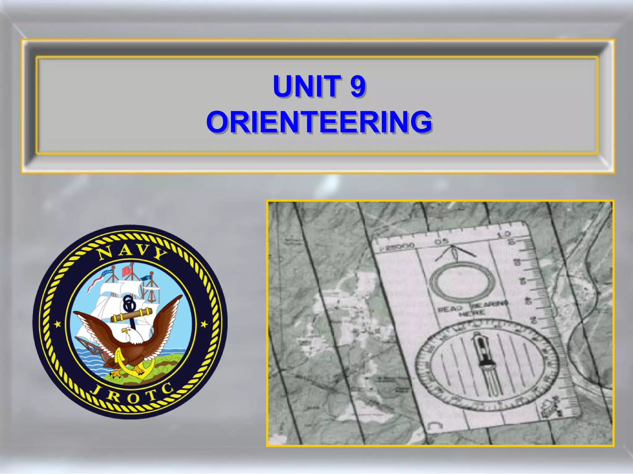
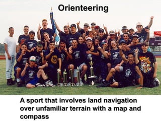
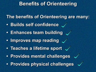
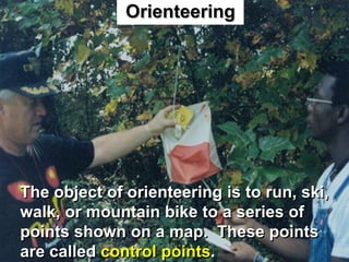
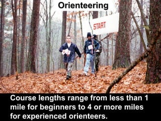
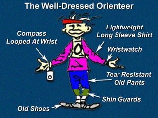
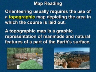
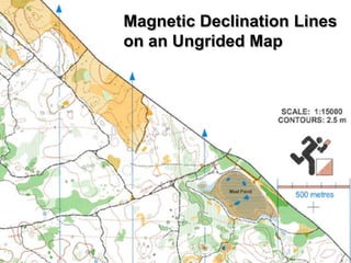
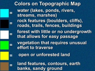
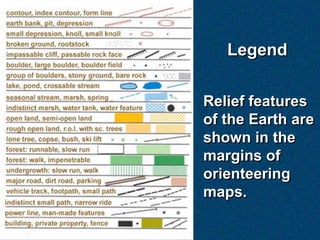
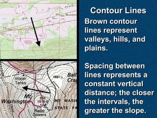
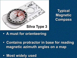
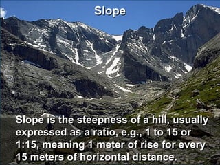
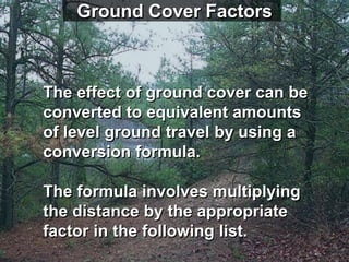
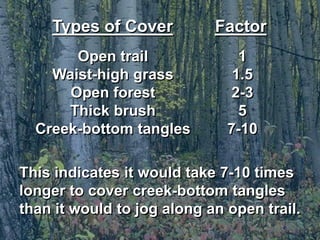
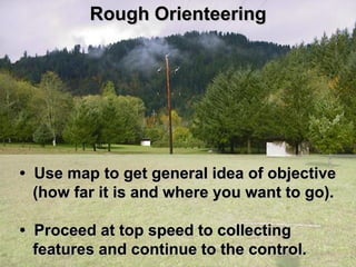
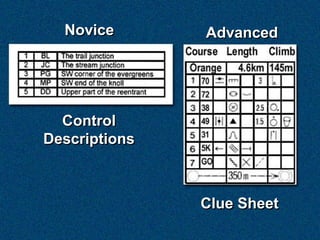
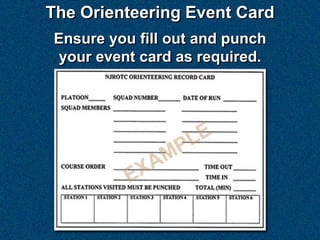
Orienteering is an outdoor sport that involves navigating through unfamiliar terrain using a map and compass. The benefits of orienteering include building self-confidence, enhancing team building skills, improving map reading abilities, and providing both mental and physical challenges. Participants must navigate to a series of control points using the map, compass, and terrain features to guide them. Course lengths can vary from less than a mile for beginners to over 4 miles for experienced orienteers. Proper clothing, equipment like the compass, and map reading skills are essential to succeed at orienteering.
Orienteering Is an outdoor activity where participant’s goal is finding the various checkpoints (with specific sequence) in a pre set course using a especially created detailed map and the compass to navigate in an unfamiliar terrain.
Can be done as a fun recreational activity or a very competitive sport requiring navigational skills, techniques, and decision making skills to bring a person from one pace to another at the least time possible.
Includes the Natural resources of the country, outdoor recreation (land, water & air), nature of mountaineering, trail class, classification, top mountains visited in the country.
PE 7 | Lesson 2: PHYSICAL FITNESS TEST AND ASSESSMENTAngela Mae Alba
The birth of the DepED Physical Fitness Test Manual came about after the review and revision workshop of the existing physical fitness tests introduced by Dr. Aparicio H. Mequi, former Chair, Philippine Sports Commission (PSC) and Director, Bureau of Physical Education and School Sports (BPESS). The workshop was inspired by the desire of the Task Force on School Sports (TFSS) to bring in the new trends and latest
researches in the field of physical fitness while we respond to the issues on test qualities and administration.
Test administration shall be treated as an essential component of the Physical Education and School Sports program. Both elementary ( Grades 4,5 and 6) and secondary pupils/students must to undergo the test during the beginning and ending of
the school year. Using a score card, each pupil/student shall be responsible to record and keep the result of his/her own
performance or the school may include these score cards in the school’s MIS.
The physical fitness test is a set of measures designed to determine one’s level of physical fitness. It has two components namely: Health-Related and Skill-Related Fitness. Each component comprises several tests and specific testing protocols. There are one thousand and one tests used worldwide but the choice of tests considered time efficiency in the administration, availability of equipment, simplicity of the procedures, and practicality of the tests.
How to Build a Module in Odoo 17 Using the Scaffold MethodCeline George
Odoo provides an option for creating a module by using a single line command. By using this command the user can make a whole structure of a module. It is very easy for a beginner to make a module. There is no need to make each file manually. This slide will show how to create a module using the scaffold method.
Introduction to AI for Nonprofits with Tapp NetworkTechSoup
Dive into the world of AI! Experts Jon Hill and Tareq Monaur will guide you through AI's role in enhancing nonprofit websites and basic marketing strategies, making it easy to understand and apply.
2024.06.01 Introducing a competency framework for languag learning materials ...Sandy Millin
http://sandymillin.wordpress.com/iateflwebinar2024
Published classroom materials form the basis of syllabuses, drive teacher professional development, and have a potentially huge influence on learners, teachers and education systems. All teachers also create their own materials, whether a few sentences on a blackboard, a highly-structured fully-realised online course, or anything in between. Despite this, the knowledge and skills needed to create effective language learning materials are rarely part of teacher training, and are mostly learnt by trial and error.
Knowledge and skills frameworks, generally called competency frameworks, for ELT teachers, trainers and managers have existed for a few years now. However, until I created one for my MA dissertation, there wasn’t one drawing together what we need to know and do to be able to effectively produce language learning materials.
This webinar will introduce you to my framework, highlighting the key competencies I identified from my research. It will also show how anybody involved in language teaching (any language, not just English!), teacher training, managing schools or developing language learning materials can benefit from using the framework.
The simplified electron and muon model, Oscillating Spacetime: The Foundation...RitikBhardwaj56
Discover the Simplified Electron and Muon Model: A New Wave-Based Approach to Understanding Particles delves into a groundbreaking theory that presents electrons and muons as rotating soliton waves within oscillating spacetime. Geared towards students, researchers, and science buffs, this book breaks down complex ideas into simple explanations. It covers topics such as electron waves, temporal dynamics, and the implications of this model on particle physics. With clear illustrations and easy-to-follow explanations, readers will gain a new outlook on the universe's fundamental nature.
June 3, 2024 Anti-Semitism Letter Sent to MIT President Kornbluth and MIT Cor...Levi Shapiro
Letter from the Congress of the United States regarding Anti-Semitism sent June 3rd to MIT President Sally Kornbluth, MIT Corp Chair, Mark Gorenberg
Dear Dr. Kornbluth and Mr. Gorenberg,
The US House of Representatives is deeply concerned by ongoing and pervasive acts of antisemitic
harassment and intimidation at the Massachusetts Institute of Technology (MIT). Failing to act decisively to ensure a safe learning environment for all students would be a grave dereliction of your responsibilities as President of MIT and Chair of the MIT Corporation.
This Congress will not stand idly by and allow an environment hostile to Jewish students to persist. The House believes that your institution is in violation of Title VI of the Civil Rights Act, and the inability or
unwillingness to rectify this violation through action requires accountability.
Postsecondary education is a unique opportunity for students to learn and have their ideas and beliefs challenged. However, universities receiving hundreds of millions of federal funds annually have denied
students that opportunity and have been hijacked to become venues for the promotion of terrorism, antisemitic harassment and intimidation, unlawful encampments, and in some cases, assaults and riots.
The House of Representatives will not countenance the use of federal funds to indoctrinate students into hateful, antisemitic, anti-American supporters of terrorism. Investigations into campus antisemitism by the Committee on Education and the Workforce and the Committee on Ways and Means have been expanded into a Congress-wide probe across all relevant jurisdictions to address this national crisis. The undersigned Committees will conduct oversight into the use of federal funds at MIT and its learning environment under authorities granted to each Committee.
• The Committee on Education and the Workforce has been investigating your institution since December 7, 2023. The Committee has broad jurisdiction over postsecondary education, including its compliance with Title VI of the Civil Rights Act, campus safety concerns over disruptions to the learning environment, and the awarding of federal student aid under the Higher Education Act.
• The Committee on Oversight and Accountability is investigating the sources of funding and other support flowing to groups espousing pro-Hamas propaganda and engaged in antisemitic harassment and intimidation of students. The Committee on Oversight and Accountability is the principal oversight committee of the US House of Representatives and has broad authority to investigate “any matter” at “any time” under House Rule X.
• The Committee on Ways and Means has been investigating several universities since November 15, 2023, when the Committee held a hearing entitled From Ivory Towers to Dark Corners: Investigating the Nexus Between Antisemitism, Tax-Exempt Universities, and Terror Financing. The Committee followed the hearing with letters to those institutions on January 10, 202
Unit 8 - Information and Communication Technology (Paper I).pdfThiyagu K
This slides describes the basic concepts of ICT, basics of Email, Emerging Technology and Digital Initiatives in Education. This presentations aligns with the UGC Paper I syllabus.
Exploiting Artificial Intelligence for Empowering Researchers and Faculty, In...Dr. Vinod Kumar Kanvaria
Exploiting Artificial Intelligence for Empowering Researchers and Faculty,
International FDP on Fundamentals of Research in Social Sciences
at Integral University, Lucknow, 06.06.2024
By Dr. Vinod Kumar Kanvaria
A Strategic Approach: GenAI in EducationPeter Windle
Artificial Intelligence (AI) technologies such as Generative AI, Image Generators and Large Language Models have had a dramatic impact on teaching, learning and assessment over the past 18 months. The most immediate threat AI posed was to Academic Integrity with Higher Education Institutes (HEIs) focusing their efforts on combating the use of GenAI in assessment. Guidelines were developed for staff and students, policies put in place too. Innovative educators have forged paths in the use of Generative AI for teaching, learning and assessments leading to pockets of transformation springing up across HEIs, often with little or no top-down guidance, support or direction.
This Gasta posits a strategic approach to integrating AI into HEIs to prepare staff, students and the curriculum for an evolving world and workplace. We will highlight the advantages of working with these technologies beyond the realm of teaching, learning and assessment by considering prompt engineering skills, industry impact, curriculum changes, and the need for staff upskilling. In contrast, not engaging strategically with Generative AI poses risks, including falling behind peers, missed opportunities and failing to ensure our graduates remain employable. The rapid evolution of AI technologies necessitates a proactive and strategic approach if we are to remain relevant.
3. Benefits of Orienteering
The benefits of Orienteering are many:
• Builds self confidence
• Enhances team building
• Improves map reading
• Teaches a lifetime sport
• Provides mental challenges
• Provides physical challenges
4. Orienteering
The object of orienteering is to run, ski,
walk, or mountain bike to a series of
points shown on a map. These points
are called control points.
6. The Well-Dressed Orienteer
Lightweight
Compass Long Sleeve Shirt
Looped At Wrist
Wristwatch
Tear Resistant
Old Pants
Shin Guards
Old Shoes
7. Map Reading
Orienteering usually requires the use of
a topographic map depicting the area in
which the course is laid out.
A topographic map is a graphic
representation of manmade and natural
features of a part of the Earth's surface.
8. Topographic Map
Orienteering maps usually are drawn to
a scale of 1:15,000 or 1:10,000, and have
5-meter contour lines or intervals.
They also show large boulders, cliffs,
ditches, and many other features.
Some of the other features that may be
shown are listed on the next screen.
9. Features
Boundaries Dams
Bridges Railroads
Buildings Rivers
Caves/Mines Roads/Trails
Coastal Features Pipelines
Contour Lines Bodies of Water
• Elevations Fences
And this is only a partial list!
10. The most useful
scale for an
orienteering map is:
1:15,000 or 1:10,000
1 inch on the map
Represents 15,000
or 10,000 inches on
the ground)
11. Direction
On most maps, north is at the top, south
to the bottom, east to the right, and west
to the left.
There is a slight difference between the
location of the north pole and that of
magnetic north. This is the variation
angle or declination angle.
13. Colors on Topographic Map
water (lakes, ponds, rivers,
streams, marshes)
rock features (boulders, cliffs),
roads, trails, fences, buildings
forest with little or no undergrowth
that allows for easy passage
vegetation that requires unusual
effort to traverse
open or unforested land
land features, contours, earth
banks, sandy ground
15. Contour Lines
Brown contour
lines represent
valleys, hills, and
plains.
Spacing between
lines represents a
constant vertical
distance; the closer
the intervals, the
greater the slope.
16. When lines are
close together, they
show a steep slope.
Similarly, when they
are far apart, they
show a gentle slope.
Contour interval is
the distance (feet or
meters) between
lines.
17. If the map contour interval is 10 feet,
this hill is approximately 130 feet high.
18. Contour lines indicate
elevation, in feet or
meters, above sea
level.
Contour lines tell
you the ups and
downs of the land.
19. Typical
Magnetic
Compass
Silva Type 3
• A must for orienteering
• Contains protractor in base for reading
magnetic azimuth angles on a map
• Most widely used
21. During orienteering, first obtain the
magnetic azimuth or bearing.
• Place edge of protractor base along
desired line of travel.
• Turn compass housing until
orienteering arrow aligns with
magnetic north reference lines.
• Turn your body until the red end of
magnetic needle aligns with the
orienteering arrow.
22. Distance is Important
in Orienteering to:
• Determine distances between control
points.
• Determine distances actually traveled.
23. Distance on a Map
If a map has a scale of 1:25000, and a
distance of 2 cm were measured on the
map between two locations, then the
actual distance along the ground would
be:
2cm x 250m/cm = 500m on the ground
24. Distance on a Map
Another method is to lay off the
measured distance on the map along
the graphic linear distance scale on
the map. This can then give you the
desired distance along the ground in
feet, meters, miles, or kilometers.
25. Distance on a Map
A third method is to use the map scales
printed along the sides of the compass
protractor base. These are often
standardized to read distances along
the ground directly in feet or meters.
26. In the field, your pace is used to
measure distance. Your pace is the
average length, in meters, of a double
step.
27. To determine your pace, count the
number of double strides you make on
a 600-meter course. This should be
done while both running and walking.
28. Land Navigation Techniques
Several methods of land navigation
techniques may be used. Depending on
the terrain, one of the following methods
may be used:
• The beeline
• The steering mark
• The contour route
29. Beeline
A straight line is followed to the desired
location, by observing terrain features,
without the use of a compass.
30. Steering Mark
Once the bearing (direction of travel) is
determined, travel to easily identifiable
way-points (steering marks), such as
trees, rocks, or houses along the way.
31. Contour Route
If you use a contour line as a trail, you
would be traveling parallel to mean sea
level.
This method is
less tiring and
more accurate
than the beeline
method because
up and down hill
travel is minimized.
32. Aiming Off
In this example, the
orienteer follows an
azimuth slightly to
the right of control
point 3, proceeds to
the stream (the
catch feature), turns
left, and follows the
stream to the
control point.
33. A Catching Feature
• A linear feature that lies beyond the
control (example: a road or fence)
• Passes by, through, or near a control
• "Saves" you if you should miss the
control and go past it
34. Attack Point
• A prominent feature near a control
(100 - 150 meters)
• Used to get you close to a control as
quickly as possible
• Numerous attack points on beginner
courses
• Few attack points on advanced
courses
35. Before You Start
First, stop and look around; then look
closely at your map.
Observe the lay of the land. Find some
fairly distinct feature, or better yet, a
group of features, within view and on
the map.
Can you see any collecting features,
catching features, or handrails that
will help you get to the first control?
36. Handrail
• Any linear feature you can follow to
where you want to go
• Examples: a stream, trail, road, fence,
brick or stone wall
37. Slope
Slope is the steepness of a hill, usually
expressed as a ratio, e.g., 1 to 15 or
1:15, meaning 1 meter of rise for every
15 meters of horizontal distance.
38. Profile
Profile refers to the shape of a hill.
Three general profiles are:
Concave - steeper as it get higher
Convex - steeper at the bottom
Uniform - constant slope from bottom
to top
40. Ground Cover Factors
The effect of ground cover can be
converted to equivalent amounts
of level ground travel by using a
conversion formula.
The formula involves multiplying
the distance by the appropriate
factor in the following list.
41. Types of Cover Factor
Open trail 1
Waist-high grass 1.5
Open forest 2-3
Thick brush 5
Creek-bottom tangles 7-10
This indicates it would take 7-10 times
longer to cover creek-bottom tangles
than it would to jog along an open trail.
42. Rough Orienteering
• Use map to get general idea of objective
(how far it is and where you want to go).
• Proceed at top speed to collecting
features and continue to the control.
43. Fine Orienteering
• Requires slower movement and
continually checking map
• Smaller features used as landmarks
• Slow and inefficient for use for entire
leg of course
44. Speeds of Orienteering
Green light – used for rough orienteering
on the easy parts of a course where a
running pace is possible
45. Speeds of Orienteering
Green light – used for rough orienteering
on the easy parts of a course where a
running pace is possible
Yellow light – a slow jog or
fast walk, being cautious
when approaching a hand-
rail or an attack point
46. Speeds of Orienteering
Green light – used for rough orienteering
on the easy parts of a course where a
running pace is possible
Yellow light – a slow jog or
fast walk, being cautious
when approaching a hand-
rail or an attack point
Red light – a slow walk in order
to use fine orienteering to locate
a control
47. Speeds of Orienteering
All course legs may not lend them-
selves to all three speeds.
Learning when to use which speed
during rough and fine orienteering
comes only through experience.
48. Course Layout Criteria
• A well-wooded area (lots of trees)
• Uninhabited if possible
• Appropriate degree of difficulty for
the orienteers who will be using it
• Good map coverage of suitable scale
49. Course Layout Criteria
Circles are control points.
A triangle indicates the
start.
A double circle indicates
the finish.
50. Control Marker
• Should be visible from
at least 10 meters away
but not more than 50
• Usually attached is a
distinctive punch used
as 'proof' you were at
that control marker
55. Orienteering Activities
Cross-country (point-to-point) – the
classic form of orienteering. Controls
on a map must be visited in order.
Score-O – Controls are visited in any
order.
Night-O – a variation on either of the
above conducted from dusk through
dark.
56. Orienteering Activities
Long-O – Courses are 1.5 to 2 times
as long as a standard course, and have
long legs and complex route choices.
57. Orienteering Activities
Long-O – Courses are 1.5 to 2 times
as long as a standard course, and have
long legs and complex route choices.
Relay-O – A variation of point-to-point.
Each team member completes a leg of
a course.
58. Orienteering Activities
Long-O – Courses are 1.5 to 2 times
as long as a standard course, and have
long legs and complex route choices.
Relay-O – A variation of point-to-point.
Each team member completes a leg of
a course.
Memory-O – The first leg of the course
is memorized. After reaching control 1,
the second leg is memorized before
going to control 2.
59. Orienteering Activities
Recently, a new orienteering activity has
been added to the list of "O" activities.
This is:
Trail-O – an orienteering course laid out
specifically for handicapped individuals.
Trails are either on firm ground or paved
paths. Once a control point is reached,
the individual must observe specific land-
scape features and make the most
accurate estimates of distance, time of
travel, height and other required items.
60. Novice Advanced
Control
Descriptions
Clue Sheet
61. The previously shown symbols are
only a few of the many used in the
sport of orienteering. A more
comprehensive listing and their
meanings are available through links
provided at the United States
Orienteering Federation (USOF) Web
site at:
http://www.us.orienteering.org
63. The Rules of Orienteering
Like all sports, certain rules must be
followed.
Fairness – a sporting attitude and a spirit
of comradeship and honesty
Nature of orienteering – no outside help;
yet provide appropriate assistance if one
is injured or honestly lost
Environmental protection – take care of
the land you are on, obeying common
sense rules and following posted signs
64. Qualification Requirements for the
NJROTC Orienteering Ribbon
1. You must be a cadet in good standing.
2. Point out and name five major terrain
features on a map and in the field.
3. Point out and name ten symbols often
found on a topographic map.
4. Use a compass effectively.
65. 5. Measure distances on a map using a
straight edge.
6. Explain "descriptive clues," "aiming
off," and "attack point."
7. Determine, by length of pace and
speed, both walking and running,
when a distance of 100 meters has
been covered over various types of
terrain.
66. 8. Successfully complete at least two
3,000- to 4,000-meter cross-country
courses.
After completion of each course, the
NSI will debrief (critique) you on your
results.
67. Subsequent Awards
A star may be awarded for
orienteering participation in
the first and subsequent
years.
A maximum of two awards per year
(including the initial ribbon award) are
authorized.
Different orienteering courses must be
used for subsequent awards.