Download to read offline
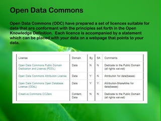


This document summarizes open spatial data sources and tools. It discusses EDINA as a provider of national online data resources and the Data Library at the University of Edinburgh. It then outlines various open data sources like Digimap, OpenStreetMap, and tools like CKAN and Unlock that can be used to access, share and map open spatial data. The document emphasizes that 80% of information has a spatial component and encourages open licensing of data.


![Who is doing what, and how do we know? [PEPRS]](https://cdn.slidesharecdn.com/ss_thumbnails/who-is-doing-what-100623032001-phpapp01-thumbnail.jpg?width=640&height=640&fit=bounds)


