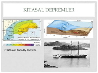
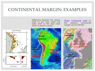
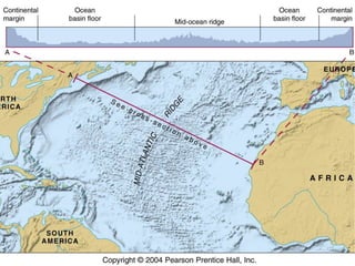
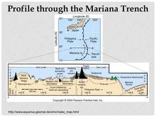
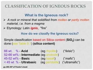
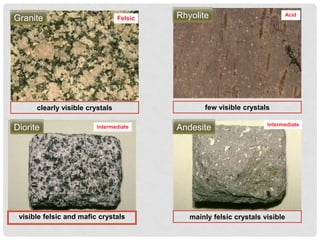
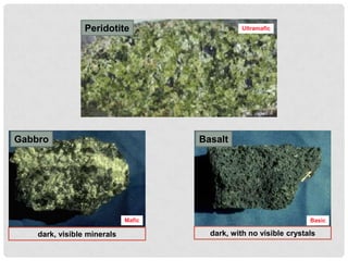
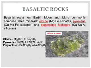
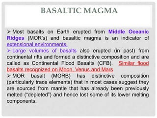
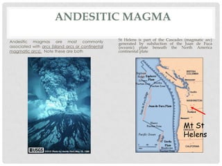
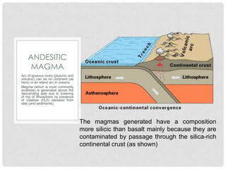
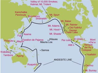
Global Jeofiziğe Giriş
         Okyanusal Litosfer


          P RO F. D R . A L I O S M A N Ö N C E L
MÜHENDISLIK BİLİMLERİ-GLOBAL JEOFIZIK-MUBİ7004
Ofis saatleri çizelgesi


Dr. Ali O. Oncel : Jeofizik, II. Kat
   (oncel@istanbul.edu.tr aliosman.oncel@gmail.com)
              Salı. 14.00-16:00
Her zaman e-mail yoluyla randevu alabilirsiniz yada açık
kapı politikasına dayanarak beni görmeye gelebilirsiniz .

     Today’s class: Oceanic Lithosphere
             Reading: Fowler Chapter 9, pp.391-416
DERS ÖĞRETİM İZLENCESİ


  Global Jeofizik İçin ders içerikleri
a. Bölüm 1: Dünya’nın İç Yapısı
b. Bölüm 2: Okyanusal Litosfer
c. Bölüm 3: İç yapıyla ilgili sismolojik ölçümler
d. Bölüm 4: Levha Hareketleri
e. Bölüm 5: Isı Akısı
  http://geop503kfupm.pbwiki.com/CourseSyllabus
Ders kitabı: The Solid Earth
             by C.M.R.      Fowler-2005


   Derecelendirme


Görevler             10 %
OKYANUS ÇUKURLARI

The crust and lithosphere
thicken away from the rift.
This is compensated by
Isostasy and the crust uplifted
in      the      rift-shoulders.
Spreading rates are generally
quoted      as   half    plate-
separation     rate.         For
example, Mid Atlantic Ridge
is spreading at a rate of 1 cm
yr-1 but the North American
Plates and Eurasian plates
are        separating         at
approximately 2 cm-1.
                                   Figure 9.1 of Fowler’s book
KITASAL SINIRLAR

• Continental Shelf – part of the
  continental margin between the
  coast and continental slope;
  slopes 0.1 degree (1:500)
• Continental Slope – part of the
  continental margin between the
  continental      rise  and    the
  continental shelf; slopes about 3-
  6 degree (1:10 to 1:20)
• Continental Rise – Part of
  continental margin between the
  continental slope and abyssal
  plain; slopes generally 1:40 to
  1:2000                               Modified after Figure 9.2 of Fowler’s book
• Abyssal Plains – deep, old ocean
  floor; well sedimented.
KITASAL DEPREMLER


(1929) and Turbidity Currents
CONTINENTAL MARGIN: EXAMPLES

         Difference between the narrow   Wider continental shelf on
         shelf on the west coast and
         wider shelf on the east coast   the   passive    continental
         which is passive margin.        margin around Britain


                South
               America
                                                   Bathymetry
                                                   map of the UK
                                                   and Europe
                           Passive
         Active            Margin
         Margin

        Peru-Chile
         Trench
Europe


           Africa
 South
America
Question: The width of ocean floor between the spreading ridge in the South Atlantic
Ocean at 30 S and the edge of the continental shelves along the east coast of South
America and the west coast of southern Africa at 3 S is approximately 3100 and 2700 km
respectively. Assuming that the spreading rate on this segment of the ridge is 38 mm y−1,
estimate the maximum age of the sea floor on either side of the South Atlantic.
North America
                                 Europe


                Atlantic Ocean
South America
                    basin         Africa
Profile through the Mariana Trench


http://www.aquarius.geomar.de/omc/make_map.html
Age of the
                                                         Ocean
                                                          Floor


http://www.ngdc.noaa.gov/mgg/image/crustageposter.jpg
CLASSIFICATION OF IGNEOUS ROCKS

                        What is the Igneous rock?
 A rock or mineral that solidified from molten or partly molten
  material, i.e. from a magma
 Etymology: Latin ignis, ''fire”
                   How do we classify the igneous rocks?
Simple classification based on Silica content (SiO2) can be
done (see Table 9.1) (silica content)

66 wt. % - Acid          (eg rhyolite)  (“felsic”)
52-66 wt% - Intermediate (eg andesite)
45-52 wt% - Basic        (eg basalt)    (“mafic”)
< 45 wt % - Ultrabasic (eg peridotite) (“ultramafic”)
pp.395-397 of Fowler’s book
The Crust and Lithosphere
  Continental crust: thicker, less dense, older
   20 km (weathered areas) to 75 km (younger areas)
   thick
  Oceanic crust: thinner, more dense, more recent
   ~7km thick
  Lithosphere: the crust and uppermost (rigid) mantle


                                     This system is dynamic, not static!

http://www.enchantedlearning.com/subjects/astronomy/planets/earth/Inside.shtml
Rock
   Cycle

          http://www.enchantedlearning.com/subjects/astronomy/planets/earth/Inside.shtml

                       Mountains     1      Sedimentary
                       (all types) erosion,    Basins                      2
                5                                                        subduction
                uplift             sedimentation

         Sea floor                   Frei system diagram         Subduction Zone
         (igneous)                                               (all types)
                           4
                      extrusion, Aesthenosphere                 metamorphism
                      volcanism (metamorphic)                     3
From: Modified after Lecture from Professor Frei
FELSIC VS. MAFIC

         Felsic                                      Mafic
• Light in color, includes                 • Dark in color, is rich in
  minerals with a lot of                     magnesium and iron
  aluminum and silicon .                     (Fe).
                                                                           Mafic
                                  Felsic


    Granite                                   Gabbro
       clearly visible crystals                   dark, visible minerals
Granite                          Felsic   Rhyolite                         Acid


      clearly visible crystals                   few visible crystals

                                                                     Intermediate
Diorite                  Intermediate     Andesite


 visible felsic and mafic crystals           mainly felsic crystals visible
Peridotite                     Ultramafic


Gabbro                               Basalt


                             Mafic                                 Basic

    dark, visible minerals             dark, with no visible crystals
BASALTIC ROCKS
Basaltic rocks on Earth, Moon and Mars commonly
comprise three minerals: olivine (Mg-Fe silicates, pyroxene
(Ca-Mg-Fe silicates) and plagioclase feldspars (Ca-Na-Al
silicates)
                                       Olivine in basalt


Olivine - Mg2SiO4 to Fe2SiO4
Pyroxene - Ca(Mg,Fe,Al)(Al,Si)2O6
Plagioclase - CaAlSi3O8 to NaAlSi3O8
BASALTIC MAGMA

 Most basalts on Earth erupted from Middle Oceanic
Ridges (MOR’s) and basaltic magma is an indicator of
extensional environments.
 Large volumes of basalts also erupted (in past) from
continental rifts and formed a distinctive composition and are
called as Continental Flood Basalts (CFB). Similar flood
basalts recognized on Moon, Venus and Mars
 MOR basalt (MORB) has distinctive composition
(particularly trace elements) that in most cases suggest they
are sourced from mantle that has already been previously
melted (“depleted”) and hence lost some of its lower melting
components.
ANDESITIC MAGMA
                                                   St Helens is part of the Cascades (magmatic arc)
Andesitic magmas are most commonly                 generated by subduction of the Juan de Fuca
associated with arcs (island arcs or continental   (oceanic) plate beneath the North America
magmatic arcs). Note these are both                continental plate


                                                                                    Mt St
                                                                                    Helens
ANDESITIC
     MAGMA
Arc of igneous rocks (plutonic and
volcanic) can be on continent (as
here) or an island arc in oceans.
Magma (which is most commonly
andesite) is generated above the
descending slab due to lowering
of mp of lithosphere by presence
of volatiles (H20) released from
slab (and sediments).


                                     The magmas generated have a composition
                                     more silicic than basalt mainly because they are
                                     contaminated by passage through the silica-rich
                                     continental crust (as shown)
ANDESITE LINE


  • Geographic boundary between the basalt/gabbro of
    the Pacific Ocean basin and the andesites at the
    subductive margins of the surrounding continents
From: http://www.eos.ncsu.edu/eos/info/mea/mea101_info/chapters_color/KimColor6_04.html
Oceanic Lithosphere - 1

Oceanic Lithosphere - 1

  • 1.
    Global Jeofiziğe Giriş Okyanusal Litosfer P RO F. D R . A L I O S M A N Ö N C E L MÜHENDISLIK BİLİMLERİ-GLOBAL JEOFIZIK-MUBİ7004
  • 2.
    Ofis saatleri çizelgesi Dr.Ali O. Oncel : Jeofizik, II. Kat (oncel@istanbul.edu.tr aliosman.oncel@gmail.com) Salı. 14.00-16:00 Her zaman e-mail yoluyla randevu alabilirsiniz yada açık kapı politikasına dayanarak beni görmeye gelebilirsiniz . Today’s class: Oceanic Lithosphere Reading: Fowler Chapter 9, pp.391-416
  • 4.
    DERS ÖĞRETİM İZLENCESİ Global Jeofizik İçin ders içerikleri a. Bölüm 1: Dünya’nın İç Yapısı b. Bölüm 2: Okyanusal Litosfer c. Bölüm 3: İç yapıyla ilgili sismolojik ölçümler d. Bölüm 4: Levha Hareketleri e. Bölüm 5: Isı Akısı http://geop503kfupm.pbwiki.com/CourseSyllabus
  • 5.
    Ders kitabı: TheSolid Earth by C.M.R. Fowler-2005 Derecelendirme Görevler 10 %
  • 6.
    OKYANUS ÇUKURLARI The crustand lithosphere thicken away from the rift. This is compensated by Isostasy and the crust uplifted in the rift-shoulders. Spreading rates are generally quoted as half plate- separation rate. For example, Mid Atlantic Ridge is spreading at a rate of 1 cm yr-1 but the North American Plates and Eurasian plates are separating at approximately 2 cm-1. Figure 9.1 of Fowler’s book
  • 7.
    KITASAL SINIRLAR • ContinentalShelf – part of the continental margin between the coast and continental slope; slopes 0.1 degree (1:500) • Continental Slope – part of the continental margin between the continental rise and the continental shelf; slopes about 3- 6 degree (1:10 to 1:20) • Continental Rise – Part of continental margin between the continental slope and abyssal plain; slopes generally 1:40 to 1:2000 Modified after Figure 9.2 of Fowler’s book • Abyssal Plains – deep, old ocean floor; well sedimented.
  • 8.
    KITASAL DEPREMLER (1929) andTurbidity Currents
  • 9.
    CONTINENTAL MARGIN: EXAMPLES Difference between the narrow Wider continental shelf on shelf on the west coast and wider shelf on the east coast the passive continental which is passive margin. margin around Britain South America Bathymetry map of the UK and Europe Passive Active Margin Margin Peru-Chile Trench
  • 10.
    Europe Africa South America
  • 11.
    Question: The widthof ocean floor between the spreading ridge in the South Atlantic Ocean at 30 S and the edge of the continental shelves along the east coast of South America and the west coast of southern Africa at 3 S is approximately 3100 and 2700 km respectively. Assuming that the spreading rate on this segment of the ridge is 38 mm y−1, estimate the maximum age of the sea floor on either side of the South Atlantic.
  • 13.
    North America Europe Atlantic Ocean South America basin Africa
  • 14.
    Profile through theMariana Trench http://www.aquarius.geomar.de/omc/make_map.html
  • 15.
    Age of the Ocean Floor http://www.ngdc.noaa.gov/mgg/image/crustageposter.jpg
  • 16.
    CLASSIFICATION OF IGNEOUSROCKS What is the Igneous rock?  A rock or mineral that solidified from molten or partly molten material, i.e. from a magma  Etymology: Latin ignis, ''fire” How do we classify the igneous rocks? Simple classification based on Silica content (SiO2) can be done (see Table 9.1) (silica content) 66 wt. % - Acid (eg rhyolite) (“felsic”) 52-66 wt% - Intermediate (eg andesite) 45-52 wt% - Basic (eg basalt) (“mafic”) < 45 wt % - Ultrabasic (eg peridotite) (“ultramafic”) pp.395-397 of Fowler’s book
  • 17.
    The Crust andLithosphere  Continental crust: thicker, less dense, older 20 km (weathered areas) to 75 km (younger areas) thick  Oceanic crust: thinner, more dense, more recent ~7km thick  Lithosphere: the crust and uppermost (rigid) mantle This system is dynamic, not static! http://www.enchantedlearning.com/subjects/astronomy/planets/earth/Inside.shtml
  • 18.
    Rock Cycle http://www.enchantedlearning.com/subjects/astronomy/planets/earth/Inside.shtml Mountains 1 Sedimentary (all types) erosion, Basins 2 5 subduction uplift sedimentation Sea floor Frei system diagram Subduction Zone (igneous) (all types) 4 extrusion, Aesthenosphere metamorphism volcanism (metamorphic) 3 From: Modified after Lecture from Professor Frei
  • 19.
    FELSIC VS. MAFIC Felsic Mafic • Light in color, includes • Dark in color, is rich in minerals with a lot of magnesium and iron aluminum and silicon . (Fe). Mafic Felsic Granite Gabbro clearly visible crystals dark, visible minerals
  • 20.
    Granite Felsic Rhyolite Acid clearly visible crystals few visible crystals Intermediate Diorite Intermediate Andesite visible felsic and mafic crystals mainly felsic crystals visible
  • 21.
    Peridotite Ultramafic Gabbro Basalt Mafic Basic dark, visible minerals dark, with no visible crystals
  • 22.
    BASALTIC ROCKS Basaltic rockson Earth, Moon and Mars commonly comprise three minerals: olivine (Mg-Fe silicates, pyroxene (Ca-Mg-Fe silicates) and plagioclase feldspars (Ca-Na-Al silicates) Olivine in basalt Olivine - Mg2SiO4 to Fe2SiO4 Pyroxene - Ca(Mg,Fe,Al)(Al,Si)2O6 Plagioclase - CaAlSi3O8 to NaAlSi3O8
  • 23.
    BASALTIC MAGMA  Mostbasalts on Earth erupted from Middle Oceanic Ridges (MOR’s) and basaltic magma is an indicator of extensional environments.  Large volumes of basalts also erupted (in past) from continental rifts and formed a distinctive composition and are called as Continental Flood Basalts (CFB). Similar flood basalts recognized on Moon, Venus and Mars  MOR basalt (MORB) has distinctive composition (particularly trace elements) that in most cases suggest they are sourced from mantle that has already been previously melted (“depleted”) and hence lost some of its lower melting components.
  • 24.
    ANDESITIC MAGMA St Helens is part of the Cascades (magmatic arc) Andesitic magmas are most commonly generated by subduction of the Juan de Fuca associated with arcs (island arcs or continental (oceanic) plate beneath the North America magmatic arcs). Note these are both continental plate Mt St Helens
  • 25.
    ANDESITIC MAGMA Arc of igneous rocks (plutonic and volcanic) can be on continent (as here) or an island arc in oceans. Magma (which is most commonly andesite) is generated above the descending slab due to lowering of mp of lithosphere by presence of volatiles (H20) released from slab (and sediments). The magmas generated have a composition more silicic than basalt mainly because they are contaminated by passage through the silica-rich continental crust (as shown)
  • 26.
    ANDESITE LINE • Geographic boundary between the basalt/gabbro of the Pacific Ocean basin and the andesites at the subductive margins of the surrounding continents From: http://www.eos.ncsu.edu/eos/info/mea/mea101_info/chapters_color/KimColor6_04.html

Editor's Notes

  • #12 Magnetic stripes not only tell us about the age of the oceans, they can also reveal the timing and location of initial continental break-up. The oldest oceanic crust that borders a continent must have formed after the continent broke apart initially, and just as sea-floor spreading began. In effect, it records the age when that continent separated from its neighbour. In the northern Atlantic, for example, oceanic crust older than 140 Ma is restricted to the eastern USA and western Saharan Africa, therefore separation of North America from this part of Africa must have commenced at this time. The oldest oceanic crust that borders South America and sub-equatorial Africa is only about 120 Ma old. Accordingly, it follows that the North Atlantic Ocean started to form before the South Atlantic Ocean.If new sea floor is being created at spreading centres, then old sea floor must be being destroyed somewhere else. The oldest sea floor lies adjacent to deep ocean trenches, which are major topographic features that partially surround the Pacific Ocean and are found in the peripheral regions of other major ocean basins. The best known example is the Marianas Trench where the sea floor plunges to more than 11 km depth. Importantly, ocean trenches cut across existing magnetic anomalies, showing that they mark the boundary between lithosphere of differing ages. Once this association had been recognised, the fate of old oceanic crust became clear – it is cycled back into the mantle, thus preserving the constant surface area of the Earth.http://openlearn.open.ac.uk/mod/resource/view.php?id=172175
  • #18 uplift: due to continental collisions, former low-lying surfaces are forced up creating mountains and plateausAs soon as higher areas are formed, weathering and erosion beginsIn general, higher mountain ranges are younger, having experienced less erosionSubduction: sediments deposited in subduction zones are transported into the earth’s mantle; igneous rocks that were never eroded also enter subduction zonesMetamorphism: subducted material undergo intense heat and pressure, are transformed into magma in the upper mantle, eventually to re-surface through mid-ocean ridges