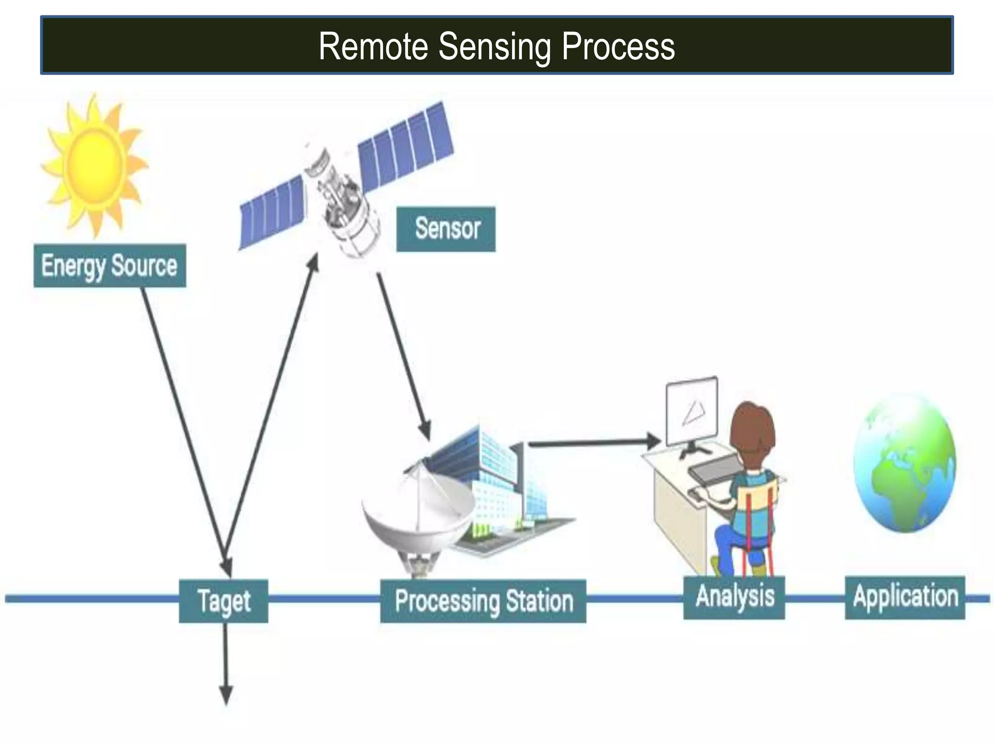
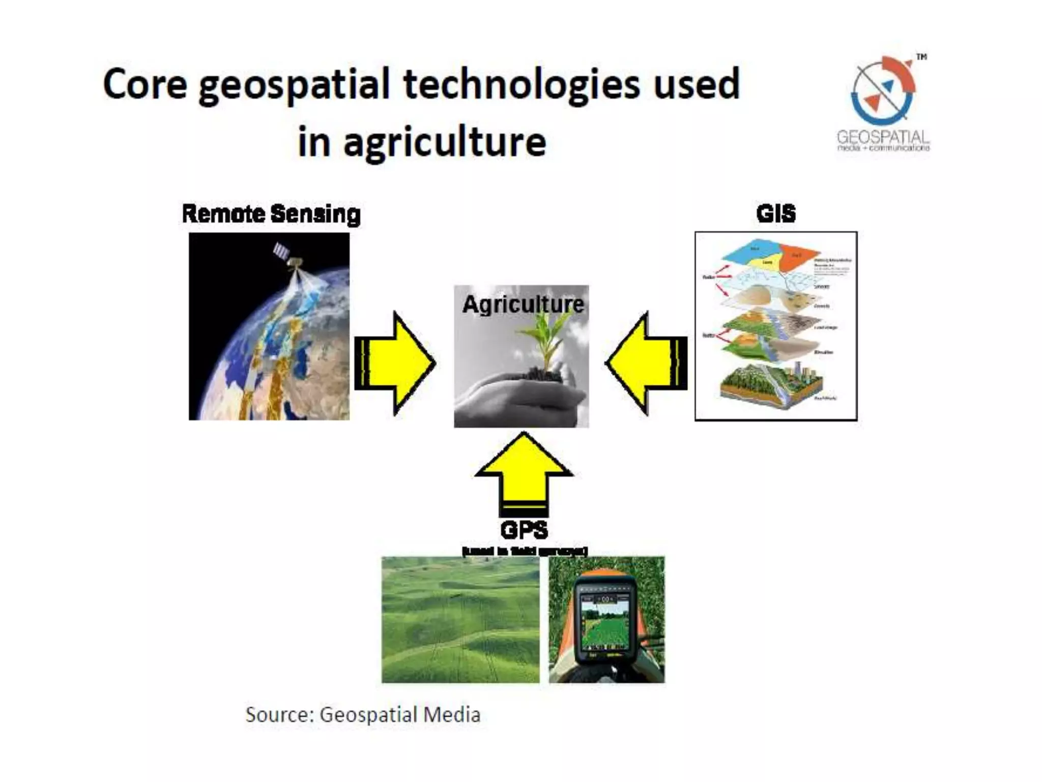
CREDIT SEMINAR
ON
APPLICATION OF REMOTE SENSING, GIS AND
GPS IN AGRICULTURE
SEMINAR INCHARGE
Dr. V. Nepalia
Professor & Head
Dept. of Agronomy
RCA, Udaipur
SPEAKER
Mohammed Mohsin
Ph.D. Scholar
Dept. of Agronomy
RCA, Udaipur
MAJOR ADVISOR
Dr. J. Choudhary
Assistant Professor
Dept. of Agronomy
RCA, Udaipur
Outlines
Introduction
Remote sensing
GIS
GPS
Application in agriculture
Conclusion
 In the late 1800s, camera were positioned above the earth surface in
balloon or kites to take oblique aerial photograph of the landscape.
 During world war I, aerial photography played an important role in
gathering information about the position and movement of enemy
troops.
 After the war, civilian use of aerial photography from airplanes began
with the systematic vertical imaging.
 In 1962 world first true operational GIS was developed in canada as a
name Canada Geographic Information System (CGIS).
 Tomlinson, who developed CGIS, is known as “Father of GIS”.
 GPS is a satellite based navigation system made up of a network of 24
satellite placed into orbit by the U. S. department of defense.
 GPS was originally intended for military applications, but in the 1980s,
the government made the system available for civilian use.
Introduction
What is Remote Sensing?
Remote sensing can be defined as the collection of data
about an object from a distance without coming in
contact with them.
Need of Remote Sensing?
 Systematic data collection
 Information about three dimensions of real objects
 Repeatability
 Global coverage
 The only solution sometimes for the otherwise inaccessible
areas
 Multipurpose information
Electromagnetic Spectrum
Satellite Orbits
Near Polar Orbits Geostationary Orbits
Remote Sensing Process
Spectral Signature
 Spectral signature is the variation of reflectance or emittance of
a material with respect to wavelengths .
 Different objects based on their structural, physical and
chemical properties reflect or emit different amount of energy in
different wave length range of the E.M.S
 The sensors measure the amount of energy reflected from that
object.
Spectral Reflectance Curve of Soil, Water and Vegetation
What is GIS?
 Geographic Information System
 System that captures, store, analyzes, manages and presents
data that are linked to location.
 Technically, a GIS is a system that include mapping software
and its application to remote sensing, land surveying, aerial
photography, mathematics and tools that can be implemented
with GIS software.
 GPS is a satellite based navigation system made up of a network of 24
satellite.
 The GPS system has three major segments
I. Space segment
II. Control segment
III. User segment
 GPS receiver compares the time a signal was transmitted by a satellite with
the time it was received.
 The time difference tells the information about distance between GPS
receiver and satellite.
 Now, with distance measurements from a few more satellite the receiver can
determine the user position.
 In GPS, signal of at least three satellites is required to calculate a 2D position
(latitude and longitude) and track movement.
 With signal from four or more satellites, the receiver can determine the 3D
position (latitude, longitude and altitude).
Triangulation
2- D
Positioning
3- D
Positioning
Application in Agriculture
Effect of Crop Health On Reflectance in Different Spectrum
Range
 NDVI was developed by a NASA scientist named Compton Tucker in a 1977.
 The Normalized Difference Vegetation Index (NDVI) is a quantitative index of
greenness ranging from 0 - 1 where 0 represents minimal or no greenness
and 1 represents maximum greenness.
 NDVI is often used for a quantitative proxy measure of vegetation health,
cover and phenology (life cycle stage) over large areas.
NDVI
Crop Identification
 Multitemporal and multispectral remote sensing imagery has been widely
used for crop identification
 The basis for separating one crop from another is the supposition that each
crop species has a specific spectral signature in a time series of
multispectral images
Spectral Behaviour
Agricultural Drought Assessment
 Since green vegetation had strong absorption of spectrum in red region and
high reflectance in infrared region, vegetation index was thus generally
formulated as various combinations of red and infrared bands.
 The monthly average temperature of the region is calculated and the values
are correlated with the monthly NDVI values in order to understand the
changes in vegetation growth with respect to the rainfall and temperature,
thereby indicating the intensity of agricultural drought.
The National Agricultural Draught Assessment and
Monitoring System (NADAMS)
Ground system Satellite system
Rainfall Aridity Index Historical VICrop calendar Land Use Current VI
Geographical Information System
Decision support System
VI Anomaly (Normal VI – Current VI) Drought Condition
Up to 10% - Normal
10-25% - Mild
25-50% - Moderate
> 50% - Severe
Drought bulletin and Map
Assessment of Agricultural Drought in Rajasthan Using Remote
Sensing Derived Vegetation Condition Index (VCI)
26
Dutta et al 2015
Crop Acerage and Crop Production Estimation
 Estimating of crop production in advance of the harvest is the great utility in
the farming such as implementing appropriate agriculture management and
pricing of export/import of agriculture commodities.
 Spectral reflectance data obtained from remote sensing is a manifestation of
integrated effect of weather, soil, cultural practices and crop characteristics
that can be used in identifying and monitoring crop growth and for
estimating crop yield.
 For large monocropped area with uniform crop distribution, coarser
resolution data such as IRS LISS I and LISS II with 72.5 and 36.25 meter
spatial resolutions respectively would be adequate.
Crop Acerage and Crop Production Estimation
 In multi-cropped region characterized by small field size and scatted crop
distribution, higher spatial resolution data such as from LISS III (23 m) would
be desirable.
 Vegetation Indices (VIs) derived from RS data acquired at maximum
vegetative growth stage are indicative of crop growth, vigour and potential
grain yield.
Wheat Acerage Estimation Using Remote Sensing Data
Hooda et al, HARSAC, Hisar
Wheat Production Estimation Using Remote Sensing Data
Hooda et al, HARSAC, Hisar
 Remote sensing in the middle-infrared and thermal infrared portion of the
EMR can provide information as to how much water is in the leaves and soil
.
 Water is a good absorber of middle-infrared energy. Therefore, leaves with
high moisture content will have low reflectance in the middle-infrared
portion.
 So high reflectance would signify low moisture content.
 Thermal Infrared used to compute the crop water stress indices (CWSI), a
measure of the crop water status .
Watershed Analysis For Water Resource Management Using Remote
Sensing and GIS Techniques
32Singh et al, 2014
Slope map of the Orr watershed, M.P., India
Land Suitability Map of Wheat Using Remote sensing and GIS
Mustafa et al, 2011, IARI New Delhi
9.6 %
23.06 %
35.44 %
15.92 %
15.95 %
Thakor et al, 2014
Identification of Disease and pest infestation
 Breakdown of foliar pigments
 Foliar physiological activity decreases.
 Less reflectance of infrared by disease affected plant and vice versa.
 Decrease in value of NDVI.
Some other application
 Monitoring and evaluation of watershed development project.
 Land use/cover & degradation mapping
 Identification of planting and harvesting dates
 Identification of problematic soils
Application of GPS and GIS in Precision Agriculture
 Location information is collected by GPS receivers for mapping field
boundaries, roads, irrigation systems, and problem areas in crops such as
weeds or disease.
 Today, farmers in developed countries use GPS mapping for more precise
application of pesticides, herbicides, and fertilizers; better control
and dispersion of these chemicals are possible through precision
agriculture.
Tractor guidance
Crop scouting
Variable rate applications
Precision Agriculture
 Remote sensing technology plays an important role in natural resources
management .
 GIS can be used in producing a soil fertility map of an area, which will help in
formulating site specific balanced fertilizer recommendation and to
understand the status of soil fertility.
 With the help of global positioning system (GPS), it is possible to record
field data (slope, aspect, nutrients, and yield) as geographically Latitude and
longitude data.
 Thus, it can be concluded that remote sensing, GIS and GPS are tools for
enhancing agricultural crop production through efficient utilization of land,
irrigation water management, crop acreage estimation, crop identification,
pest and disease management and drought assessment etc.
Mohsin final seminar

Mohsin final seminar

  • 1.
    CREDIT SEMINAR ON APPLICATION OFREMOTE SENSING, GIS AND GPS IN AGRICULTURE SEMINAR INCHARGE Dr. V. Nepalia Professor & Head Dept. of Agronomy RCA, Udaipur SPEAKER Mohammed Mohsin Ph.D. Scholar Dept. of Agronomy RCA, Udaipur MAJOR ADVISOR Dr. J. Choudhary Assistant Professor Dept. of Agronomy RCA, Udaipur
  • 2.
  • 3.
     In thelate 1800s, camera were positioned above the earth surface in balloon or kites to take oblique aerial photograph of the landscape.  During world war I, aerial photography played an important role in gathering information about the position and movement of enemy troops.  After the war, civilian use of aerial photography from airplanes began with the systematic vertical imaging.  In 1962 world first true operational GIS was developed in canada as a name Canada Geographic Information System (CGIS).  Tomlinson, who developed CGIS, is known as “Father of GIS”.  GPS is a satellite based navigation system made up of a network of 24 satellite placed into orbit by the U. S. department of defense.  GPS was originally intended for military applications, but in the 1980s, the government made the system available for civilian use. Introduction
  • 4.
    What is RemoteSensing? Remote sensing can be defined as the collection of data about an object from a distance without coming in contact with them.
  • 5.
    Need of RemoteSensing?  Systematic data collection  Information about three dimensions of real objects  Repeatability  Global coverage  The only solution sometimes for the otherwise inaccessible areas  Multipurpose information
  • 6.
  • 7.
    Satellite Orbits Near PolarOrbits Geostationary Orbits
  • 8.
  • 9.
    Spectral Signature  Spectralsignature is the variation of reflectance or emittance of a material with respect to wavelengths .  Different objects based on their structural, physical and chemical properties reflect or emit different amount of energy in different wave length range of the E.M.S  The sensors measure the amount of energy reflected from that object.
  • 10.
    Spectral Reflectance Curveof Soil, Water and Vegetation
  • 11.
    What is GIS? Geographic Information System  System that captures, store, analyzes, manages and presents data that are linked to location.  Technically, a GIS is a system that include mapping software and its application to remote sensing, land surveying, aerial photography, mathematics and tools that can be implemented with GIS software.
  • 14.
     GPS isa satellite based navigation system made up of a network of 24 satellite.  The GPS system has three major segments I. Space segment II. Control segment III. User segment
  • 15.
     GPS receivercompares the time a signal was transmitted by a satellite with the time it was received.  The time difference tells the information about distance between GPS receiver and satellite.  Now, with distance measurements from a few more satellite the receiver can determine the user position.  In GPS, signal of at least three satellites is required to calculate a 2D position (latitude and longitude) and track movement.  With signal from four or more satellites, the receiver can determine the 3D position (latitude, longitude and altitude).
  • 16.
  • 17.
  • 19.
    Effect of CropHealth On Reflectance in Different Spectrum Range
  • 20.
     NDVI wasdeveloped by a NASA scientist named Compton Tucker in a 1977.  The Normalized Difference Vegetation Index (NDVI) is a quantitative index of greenness ranging from 0 - 1 where 0 represents minimal or no greenness and 1 represents maximum greenness.  NDVI is often used for a quantitative proxy measure of vegetation health, cover and phenology (life cycle stage) over large areas.
  • 21.
  • 22.
    Crop Identification  Multitemporaland multispectral remote sensing imagery has been widely used for crop identification  The basis for separating one crop from another is the supposition that each crop species has a specific spectral signature in a time series of multispectral images
  • 23.
  • 24.
    Agricultural Drought Assessment Since green vegetation had strong absorption of spectrum in red region and high reflectance in infrared region, vegetation index was thus generally formulated as various combinations of red and infrared bands.  The monthly average temperature of the region is calculated and the values are correlated with the monthly NDVI values in order to understand the changes in vegetation growth with respect to the rainfall and temperature, thereby indicating the intensity of agricultural drought.
  • 25.
    The National AgriculturalDraught Assessment and Monitoring System (NADAMS) Ground system Satellite system Rainfall Aridity Index Historical VICrop calendar Land Use Current VI Geographical Information System Decision support System VI Anomaly (Normal VI – Current VI) Drought Condition Up to 10% - Normal 10-25% - Mild 25-50% - Moderate > 50% - Severe Drought bulletin and Map
  • 26.
    Assessment of AgriculturalDrought in Rajasthan Using Remote Sensing Derived Vegetation Condition Index (VCI) 26 Dutta et al 2015
  • 27.
    Crop Acerage andCrop Production Estimation  Estimating of crop production in advance of the harvest is the great utility in the farming such as implementing appropriate agriculture management and pricing of export/import of agriculture commodities.  Spectral reflectance data obtained from remote sensing is a manifestation of integrated effect of weather, soil, cultural practices and crop characteristics that can be used in identifying and monitoring crop growth and for estimating crop yield.  For large monocropped area with uniform crop distribution, coarser resolution data such as IRS LISS I and LISS II with 72.5 and 36.25 meter spatial resolutions respectively would be adequate.
  • 28.
    Crop Acerage andCrop Production Estimation  In multi-cropped region characterized by small field size and scatted crop distribution, higher spatial resolution data such as from LISS III (23 m) would be desirable.  Vegetation Indices (VIs) derived from RS data acquired at maximum vegetative growth stage are indicative of crop growth, vigour and potential grain yield.
  • 29.
    Wheat Acerage EstimationUsing Remote Sensing Data Hooda et al, HARSAC, Hisar
  • 30.
    Wheat Production EstimationUsing Remote Sensing Data Hooda et al, HARSAC, Hisar
  • 31.
     Remote sensingin the middle-infrared and thermal infrared portion of the EMR can provide information as to how much water is in the leaves and soil .  Water is a good absorber of middle-infrared energy. Therefore, leaves with high moisture content will have low reflectance in the middle-infrared portion.  So high reflectance would signify low moisture content.  Thermal Infrared used to compute the crop water stress indices (CWSI), a measure of the crop water status .
  • 32.
    Watershed Analysis ForWater Resource Management Using Remote Sensing and GIS Techniques 32Singh et al, 2014 Slope map of the Orr watershed, M.P., India
  • 33.
    Land Suitability Mapof Wheat Using Remote sensing and GIS Mustafa et al, 2011, IARI New Delhi 9.6 % 23.06 % 35.44 % 15.92 % 15.95 %
  • 34.
  • 35.
    Identification of Diseaseand pest infestation  Breakdown of foliar pigments  Foliar physiological activity decreases.  Less reflectance of infrared by disease affected plant and vice versa.  Decrease in value of NDVI.
  • 36.
    Some other application Monitoring and evaluation of watershed development project.  Land use/cover & degradation mapping  Identification of planting and harvesting dates  Identification of problematic soils
  • 37.
    Application of GPSand GIS in Precision Agriculture  Location information is collected by GPS receivers for mapping field boundaries, roads, irrigation systems, and problem areas in crops such as weeds or disease.  Today, farmers in developed countries use GPS mapping for more precise application of pesticides, herbicides, and fertilizers; better control and dispersion of these chemicals are possible through precision agriculture. Tractor guidance Crop scouting Variable rate applications
  • 38.
  • 39.
     Remote sensingtechnology plays an important role in natural resources management .  GIS can be used in producing a soil fertility map of an area, which will help in formulating site specific balanced fertilizer recommendation and to understand the status of soil fertility.  With the help of global positioning system (GPS), it is possible to record field data (slope, aspect, nutrients, and yield) as geographically Latitude and longitude data.  Thus, it can be concluded that remote sensing, GIS and GPS are tools for enhancing agricultural crop production through efficient utilization of land, irrigation water management, crop acreage estimation, crop identification, pest and disease management and drought assessment etc.

Editor's Notes

  • #7 Formally the first world climate conference 1979 recognized climate change as a serious problem. A number of intergovernmental conferences focusing on climate change were held in 1980s and early 1990s
  • #8 Formally the first world climate conference 1979 recognized climate change as a serious problem. A number of intergovernmental conferences focusing on climate change were held in 1980s and early 1990s
  • #9 Formally the first world climate conference 1979 recognized climate change as a serious problem. A number of intergovernmental conferences focusing on climate change were held in 1980s and early 1990s
  • #11 Formally the first world climate conference 1979 recognized climate change as a serious problem. A number of intergovernmental conferences focusing on climate change were held in 1980s and early 1990s
  • #17 Formally the first world climate conference 1979 recognized climate change as a serious problem. A number of intergovernmental conferences focusing on climate change were held in 1980s and early 1990s
  • #19 Formally the first world climate conference 1979 recognized climate change as a serious problem. A number of intergovernmental conferences focusing on climate change were held in 1980s and early 1990s
  • #20 Formally the first world climate conference 1979 recognized climate change as a serious problem. A number of intergovernmental conferences focusing on climate change were held in 1980s and early 1990s
  • #22 Formally the first world climate conference 1979 recognized climate change as a serious problem. A number of intergovernmental conferences focusing on climate change were held in 1980s and early 1990s
  • #24 Formally the first world climate conference 1979 recognized climate change as a serious problem. A number of intergovernmental conferences focusing on climate change were held in 1980s and early 1990s
  • #30 Formally the first world climate conference 1979 recognized climate change as a serious problem. A number of intergovernmental conferences focusing on climate change were held in 1980s and early 1990s
  • #34 Formally the first world climate conference 1979 recognized climate change as a serious problem. A number of intergovernmental conferences focusing on climate change were held in 1980s and early 1990s
  • #35 Formally the first world climate conference 1979 recognized climate change as a serious problem. A number of intergovernmental conferences focusing on climate change were held in 1980s and early 1990s
  • #39 Formally the first world climate conference 1979 recognized climate change as a serious problem. A number of intergovernmental conferences focusing on climate change were held in 1980s and early 1990s