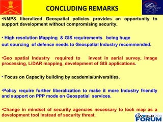
The document outlines India's national geospatial policies regarding public safety, security, and disaster management, emphasizing the strategic need for liberalizing access to spatial data while ensuring national security. It details various aspects of mapping policies, remote sensing data, and aerial photography, highlighting the balancing act between facilitating development and protecting sensitive information. The text concludes with recommendations for further liberalization and collaboration with the geospatial industry to enhance capabilities while changing perceptions of geospatial data from a security threat to a development tool.