SlideShare a Scribd company logo
MapMap
ScaleScale
Lab ThreeLab Three
Map Scale
• The scale of a map
indicates how much
the Earth has been
reduced for
reproduction on that
map.
• In practical terms, scale is the relationship
between the distance shown on a map
and the actual distance that it represents
on the Earth.
Map Scale
Ways to Indicate Scale
1. Graphic scales
– See figure 1 in lab
manual
2. Fractional scales
– Example 1:24,000
Graphic Scale
There are two common ways to indicate the scale of a map:
Graphic Scales
• The graphic scale of a
map is a bar graph
graduates by
distance.
– Figure one in the lab
manual shows the
graphic map scale
from a U.S. Geological
Survey topographic
map.
• To use a graphic scale, simply measure a
distance on the map (or mark off the
distance on the edge of a piece of paper),
then compare the measured distance to
the bar graph to determine the actual
distance represented.
Graphic Scales
On some graphic scales, “zero” is not at the far left, this
is to make it easier to read fractions.
Graphic Scales
• Graphic scales are useful since they
remain accurate even if the map is
enlarged or reduced.
Graphic Scales
Fractional Scale
• The fractional scale or
the representative
scale expresses the
scale of a map as a
fraction or ratio.
– 1/24,000 or 1:24,000
Fractional Scale: 1/24,000 or
1:24,000
• This scale, which is read “one to twenty-
four thousand”, says that one unit of
measurement on the map represents
24,000 units of measurement on the
Earth.
• At this scale, one centimeter on the map
represents an actual distance of 24,000
centimeters on the Earth, and one inch on
the map equals 24,000 inches on the
map.
– Units of measurement must be the same in
both the numerator and the denominator.
Fractional Scale: 1/24,000 or
1:24,000
Computing Distances with
Fractional Scales
1. Use a ruler to measure the
distance on the map in inches
(or centimeters). This is the
measured distance.
2. Multiply the measured distance
by the map’s fractional scale
denominator. This will give you
the actual distance in inches (or
centimeters).
3. To convert your actual distance
in inches (or centimeters) to
other units, use the following
formulas:
To determine distances represented on a map by
using the fractional scale:
Conversions
• To determine the distance in feet, actual
distance in inches / 12
• To determine the distance in miles, actual
distance in inches / 63,360
• To determine the distance in meters,
actual distance in centimeters / 100
• To determine the distance in kilometers,
actual distance in centimeters / 100,000
English Measurements
• 1 mile = 5280 ft
• 1 mile = 63360 inches
• 1 foot = 12 inches
Metric Measurements
• 1 Kilometer (Km) = 1,000 meters (m)
• 1 Kilometer (Km) = 100,000 cm
• 1 Kilometer (Km) = 1,000,000 mm
• 1 meter = 100 centimeters (cm)
• 1 centimeter = 10 millimeters (mm)
Examples
• If a map has a scale of 1/24,000, a
measured distance of 8.25 inches on the
map represents an actual distance of
198,000 inches
– 8.25 X 24,000 = 198,000 inches
– 198,000 inches / 12 = 16,500 feet
– 198,000 inches / 63,360 = 3.1 miles
Examples
• If a map has a scale of 1/50,000, a
measured distance of 22 centimeters on
the map represents an actual distance of
1,100,000 cm
– 22 cm X 50,000 = 1,100,000 cm
• To calculate the actual distance in meters
and kilometers:
– 1,100,000 cm / 100 = 11,000 meters
– 1,100,000 cm / 100,000 = 11 kilometers
Large Versus Small Scale Maps
• Large scale maps refer to maps with a relatively large
representative fraction such as 1/10,000.
– Large scale maps show a small area of the Earth in great detail.
• Small scale maps refer to maps with a relatively small
representative fraction like 1/1,000,000.
– Small scale maps show large areas in less detail.
Small Scale Medium Scale Large Scale

More Related Content

What's hot

Cartography lec #4
Cartography lec #4Cartography lec #4
Cartography lec #4
Nazir Ahmed
 
Geography Skills: Scale
Geography Skills:  ScaleGeography Skills:  Scale
Geography Skills: Scale
Tim Bonnar
 
Basics to gis concepts unit i
Basics to gis concepts unit iBasics to gis concepts unit i
Basics to gis concepts unit i
H.M College of science and technology, Manjeri
 
reading maps
reading mapsreading maps
reading maps
Shanson Shaji
 
Map Reading and Interpretation
Map Reading and InterpretationMap Reading and Interpretation
Map Reading and Interpretation
Yonas Gemeda
 
datum
datumdatum
datum
Riya Gupta
 
Plateform and sensors of remote sensing
Plateform and sensors of remote sensingPlateform and sensors of remote sensing
Plateform and sensors of remote sensing
GOPAL JI GUPTA
 
land suitability under R.S and G.I.S
land suitability under R.S and G.I.Sland suitability under R.S and G.I.S
land suitability under R.S and G.I.S
hena parveen
 
Different Types of Maps
Different Types of MapsDifferent Types of Maps
Different Types of Mapscpbrown10
 
Map scale and projection
Map scale and projectionMap scale and projection
Map scale and projectionlschmidt1170
 
Raster data model
Raster data modelRaster data model
Raster data model
Pramoda Raj
 
Basics in Cartography
Basics in Cartography Basics in Cartography
Basics in Cartography
Mohd Akhter Ali
 
UTM UNIVERSAL TRANSVERSE MERCATOR
UTM UNIVERSAL TRANSVERSE MERCATORUTM UNIVERSAL TRANSVERSE MERCATOR
UTM UNIVERSAL TRANSVERSE MERCATOR
Muhammad Aamir Manzoor
 
Aerial photography- Concept and Terminologies
Aerial photography- Concept and Terminologies Aerial photography- Concept and Terminologies
Aerial photography- Concept and Terminologies
UTTIYACHATTOPADHYAY2
 
Types of GIS Data
Types of GIS DataTypes of GIS Data
Types of GIS Data
Preeti Prajapati
 
Topographic maps presentation_mine
Topographic maps presentation_mineTopographic maps presentation_mine
Topographic maps presentation_minemisterbatroms
 
Spatial analysis and Analysis Tools
Spatial analysis and Analysis ToolsSpatial analysis and Analysis Tools
Spatial analysis and Analysis Tools
Swapnil Shrivastav
 
The universal transverse mercator system
The universal transverse mercator systemThe universal transverse mercator system
The universal transverse mercator systemMenga Bhaskar
 

What's hot (20)

Cartography lec #4
Cartography lec #4Cartography lec #4
Cartography lec #4
 
Geography Skills: Scale
Geography Skills:  ScaleGeography Skills:  Scale
Geography Skills: Scale
 
Basics to gis concepts unit i
Basics to gis concepts unit iBasics to gis concepts unit i
Basics to gis concepts unit i
 
reading maps
reading mapsreading maps
reading maps
 
Map Reading and Interpretation
Map Reading and InterpretationMap Reading and Interpretation
Map Reading and Interpretation
 
gis
gisgis
gis
 
datum
datumdatum
datum
 
Plateform and sensors of remote sensing
Plateform and sensors of remote sensingPlateform and sensors of remote sensing
Plateform and sensors of remote sensing
 
land suitability under R.S and G.I.S
land suitability under R.S and G.I.Sland suitability under R.S and G.I.S
land suitability under R.S and G.I.S
 
Different Types of Maps
Different Types of MapsDifferent Types of Maps
Different Types of Maps
 
Map scale and projection
Map scale and projectionMap scale and projection
Map scale and projection
 
Raster data model
Raster data modelRaster data model
Raster data model
 
Basics in Cartography
Basics in Cartography Basics in Cartography
Basics in Cartography
 
UTM UNIVERSAL TRANSVERSE MERCATOR
UTM UNIVERSAL TRANSVERSE MERCATORUTM UNIVERSAL TRANSVERSE MERCATOR
UTM UNIVERSAL TRANSVERSE MERCATOR
 
Aerial photography- Concept and Terminologies
Aerial photography- Concept and Terminologies Aerial photography- Concept and Terminologies
Aerial photography- Concept and Terminologies
 
Types of GIS Data
Types of GIS DataTypes of GIS Data
Types of GIS Data
 
Topographic maps presentation_mine
Topographic maps presentation_mineTopographic maps presentation_mine
Topographic maps presentation_mine
 
Spatial analysis and Analysis Tools
Spatial analysis and Analysis ToolsSpatial analysis and Analysis Tools
Spatial analysis and Analysis Tools
 
The universal transverse mercator system
The universal transverse mercator systemThe universal transverse mercator system
The universal transverse mercator system
 
Topographic Maps Notes
Topographic Maps NotesTopographic Maps Notes
Topographic Maps Notes
 

Similar to Lab three map scale

Scale and distance
Scale and distanceScale and distance
Scale and distance
Steven Heath
 
Latitude, Longitude, And Scale
Latitude, Longitude, And ScaleLatitude, Longitude, And Scale
Latitude, Longitude, And Scaleacavis
 
Scale And Distance
Scale And DistanceScale And Distance
Scale And Distanceigrant
 
INTRODUCTION TO SURVEYING
INTRODUCTION TO SURVEYINGINTRODUCTION TO SURVEYING
INTRODUCTION TO SURVEYING
farhana saiyed
 
M09U01_ppt_cartograph.ppt
M09U01_ppt_cartograph.pptM09U01_ppt_cartograph.ppt
M09U01_ppt_cartograph.ppt
RalphNavelino3
 
Mapwork skills.pptx
Mapwork skills.pptxMapwork skills.pptx
Mapwork skills.pptx
Karl Mberema
 
map reading unit 1.pdf
map reading unit 1.pdfmap reading unit 1.pdf
map reading unit 1.pdf
warkisafile1
 
Area_Contour.ppt
Area_Contour.pptArea_Contour.ppt
Area_Contour.ppt
VijayalakshmiR64
 
Digital image & linear stretching
Digital image & linear stretchingDigital image & linear stretching
Digital image & linear stretching
Kamlesh Kumar
 
1 Introduction.pptx
1 Introduction.pptx1 Introduction.pptx
1 Introduction.pptx
birendraKumarShresth3
 
geographic techniques.ppt
geographic techniques.pptgeographic techniques.ppt
geographic techniques.ppt
ssuser2350ae
 
Social Science Grade 8 Maps and Globes.pptx
Social Science Grade 8 Maps and Globes.pptxSocial Science Grade 8 Maps and Globes.pptx
Social Science Grade 8 Maps and Globes.pptx
AntonHartman
 
06. map work
06. map work06. map work
06. map work
rahimchanzi
 
06. map work
06. map work06. map work
06. map work
rahimchanzi
 
Class 1_Surveying.pdf
Class 1_Surveying.pdfClass 1_Surveying.pdf
Class 1_Surveying.pdf
RahulKumar703538
 
SOLAR IMPULSE - LAB WORK - MODELS (ENG)
SOLAR IMPULSE - LAB WORK - MODELS (ENG)SOLAR IMPULSE - LAB WORK - MODELS (ENG)
SOLAR IMPULSE - LAB WORK - MODELS (ENG)
Solar Impulse
 
8.Charts
8.Charts8.Charts
8.Charts
AmenBAL
 
Scale and scale factor
Scale and scale factorScale and scale factor
Scale and scale factor
sciencenerd42 McCarthy
 
Chapter 2 - Topo Map Reading
Chapter 2 - Topo Map ReadingChapter 2 - Topo Map Reading
Chapter 2 - Topo Map Reading
GeographyByTian
 
LS GE Slides - Map Reading
LS GE Slides - Map ReadingLS GE Slides - Map Reading
LS GE Slides - Map Reading
LEEENNA
 

Similar to Lab three map scale (20)

Scale and distance
Scale and distanceScale and distance
Scale and distance
 
Latitude, Longitude, And Scale
Latitude, Longitude, And ScaleLatitude, Longitude, And Scale
Latitude, Longitude, And Scale
 
Scale And Distance
Scale And DistanceScale And Distance
Scale And Distance
 
INTRODUCTION TO SURVEYING
INTRODUCTION TO SURVEYINGINTRODUCTION TO SURVEYING
INTRODUCTION TO SURVEYING
 
M09U01_ppt_cartograph.ppt
M09U01_ppt_cartograph.pptM09U01_ppt_cartograph.ppt
M09U01_ppt_cartograph.ppt
 
Mapwork skills.pptx
Mapwork skills.pptxMapwork skills.pptx
Mapwork skills.pptx
 
map reading unit 1.pdf
map reading unit 1.pdfmap reading unit 1.pdf
map reading unit 1.pdf
 
Area_Contour.ppt
Area_Contour.pptArea_Contour.ppt
Area_Contour.ppt
 
Digital image & linear stretching
Digital image & linear stretchingDigital image & linear stretching
Digital image & linear stretching
 
1 Introduction.pptx
1 Introduction.pptx1 Introduction.pptx
1 Introduction.pptx
 
geographic techniques.ppt
geographic techniques.pptgeographic techniques.ppt
geographic techniques.ppt
 
Social Science Grade 8 Maps and Globes.pptx
Social Science Grade 8 Maps and Globes.pptxSocial Science Grade 8 Maps and Globes.pptx
Social Science Grade 8 Maps and Globes.pptx
 
06. map work
06. map work06. map work
06. map work
 
06. map work
06. map work06. map work
06. map work
 
Class 1_Surveying.pdf
Class 1_Surveying.pdfClass 1_Surveying.pdf
Class 1_Surveying.pdf
 
SOLAR IMPULSE - LAB WORK - MODELS (ENG)
SOLAR IMPULSE - LAB WORK - MODELS (ENG)SOLAR IMPULSE - LAB WORK - MODELS (ENG)
SOLAR IMPULSE - LAB WORK - MODELS (ENG)
 
8.Charts
8.Charts8.Charts
8.Charts
 
Scale and scale factor
Scale and scale factorScale and scale factor
Scale and scale factor
 
Chapter 2 - Topo Map Reading
Chapter 2 - Topo Map ReadingChapter 2 - Topo Map Reading
Chapter 2 - Topo Map Reading
 
LS GE Slides - Map Reading
LS GE Slides - Map ReadingLS GE Slides - Map Reading
LS GE Slides - Map Reading
 

More from Lisa Schmidt

Chapter 1 A World Of Regions
Chapter 1 A World Of RegionsChapter 1 A World Of Regions
Chapter 1 A World Of Regions
Lisa Schmidt
 
Eastern europe
Eastern europeEastern europe
Eastern europe
Lisa Schmidt
 
The giant ancient forest you cannot see coyote crossing
The giant ancient forest you cannot see   coyote crossingThe giant ancient forest you cannot see   coyote crossing
The giant ancient forest you cannot see coyote crossing
Lisa Schmidt
 
Summer geog lab 2016 schmidt
Summer geog lab 2016 schmidtSummer geog lab 2016 schmidt
Summer geog lab 2016 schmidt
Lisa Schmidt
 
Summer geog 101 2016 schmidt
Summer geog 101 2016 schmidtSummer geog 101 2016 schmidt
Summer geog 101 2016 schmidt
Lisa Schmidt
 
Summer 2016 geog 110 schmidt
Summer 2016 geog 110 schmidtSummer 2016 geog 110 schmidt
Summer 2016 geog 110 schmidt
Lisa Schmidt
 
Daylight saving time may have health costs la times
Daylight saving time may have health costs   la timesDaylight saving time may have health costs   la times
Daylight saving time may have health costs la times
Lisa Schmidt
 
Daylight saving time could end in california the sacramento bee
Daylight saving time could end in california   the sacramento beeDaylight saving time could end in california   the sacramento bee
Daylight saving time could end in california the sacramento bee
Lisa Schmidt
 
Ch 3 worksheet edited
Ch 3 worksheet editedCh 3 worksheet edited
Ch 3 worksheet edited
Lisa Schmidt
 
Intro spring 2016
Intro spring 2016Intro spring 2016
Intro spring 2016
Lisa Schmidt
 
Intro spring 2016 geog 101 l
Intro spring 2016 geog 101 lIntro spring 2016 geog 101 l
Intro spring 2016 geog 101 l
Lisa Schmidt
 
Syllabus geography 102 spring 2016
Syllabus geography 102 spring 2016Syllabus geography 102 spring 2016
Syllabus geography 102 spring 2016
Lisa Schmidt
 
Could a great quake strike on the enigmatic san jacinto fault temblor
Could a great quake strike on the enigmatic san jacinto fault    temblorCould a great quake strike on the enigmatic san jacinto fault    temblor
Could a great quake strike on the enigmatic san jacinto fault temblor
Lisa Schmidt
 
Introspringonlinegeog110 14 wk
Introspringonlinegeog110 14 wkIntrospringonlinegeog110 14 wk
Introspringonlinegeog110 14 wk
Lisa Schmidt
 
Spring 2016 syllabus geog 110 sect 71
Spring 2016 syllabus geog 110 sect 71Spring 2016 syllabus geog 110 sect 71
Spring 2016 syllabus geog 110 sect 71
Lisa Schmidt
 
Spring geog 101 mon 2016 schmid
Spring geog 101 mon 2016 schmidSpring geog 101 mon 2016 schmid
Spring geog 101 mon 2016 schmid
Lisa Schmidt
 
Geog lab syllabus wed spring 2016
Geog lab syllabus wed spring 2016Geog lab syllabus wed spring 2016
Geog lab syllabus wed spring 2016
Lisa Schmidt
 
Will exxon have to pay for years of misleading the public bill moyers
Will exxon have to pay for years of misleading the public    bill moyersWill exxon have to pay for years of misleading the public    bill moyers
Will exxon have to pay for years of misleading the public bill moyers
Lisa Schmidt
 
Periodic table's 7th row completed with discovery of four new elements ifl ...
Periodic table's 7th row completed with discovery of four new elements   ifl ...Periodic table's 7th row completed with discovery of four new elements   ifl ...
Periodic table's 7th row completed with discovery of four new elements ifl ...
Lisa Schmidt
 
Geography basics
Geography basicsGeography basics
Geography basics
Lisa Schmidt
 

More from Lisa Schmidt (20)

Chapter 1 A World Of Regions
Chapter 1 A World Of RegionsChapter 1 A World Of Regions
Chapter 1 A World Of Regions
 
Eastern europe
Eastern europeEastern europe
Eastern europe
 
The giant ancient forest you cannot see coyote crossing
The giant ancient forest you cannot see   coyote crossingThe giant ancient forest you cannot see   coyote crossing
The giant ancient forest you cannot see coyote crossing
 
Summer geog lab 2016 schmidt
Summer geog lab 2016 schmidtSummer geog lab 2016 schmidt
Summer geog lab 2016 schmidt
 
Summer geog 101 2016 schmidt
Summer geog 101 2016 schmidtSummer geog 101 2016 schmidt
Summer geog 101 2016 schmidt
 
Summer 2016 geog 110 schmidt
Summer 2016 geog 110 schmidtSummer 2016 geog 110 schmidt
Summer 2016 geog 110 schmidt
 
Daylight saving time may have health costs la times
Daylight saving time may have health costs   la timesDaylight saving time may have health costs   la times
Daylight saving time may have health costs la times
 
Daylight saving time could end in california the sacramento bee
Daylight saving time could end in california   the sacramento beeDaylight saving time could end in california   the sacramento bee
Daylight saving time could end in california the sacramento bee
 
Ch 3 worksheet edited
Ch 3 worksheet editedCh 3 worksheet edited
Ch 3 worksheet edited
 
Intro spring 2016
Intro spring 2016Intro spring 2016
Intro spring 2016
 
Intro spring 2016 geog 101 l
Intro spring 2016 geog 101 lIntro spring 2016 geog 101 l
Intro spring 2016 geog 101 l
 
Syllabus geography 102 spring 2016
Syllabus geography 102 spring 2016Syllabus geography 102 spring 2016
Syllabus geography 102 spring 2016
 
Could a great quake strike on the enigmatic san jacinto fault temblor
Could a great quake strike on the enigmatic san jacinto fault    temblorCould a great quake strike on the enigmatic san jacinto fault    temblor
Could a great quake strike on the enigmatic san jacinto fault temblor
 
Introspringonlinegeog110 14 wk
Introspringonlinegeog110 14 wkIntrospringonlinegeog110 14 wk
Introspringonlinegeog110 14 wk
 
Spring 2016 syllabus geog 110 sect 71
Spring 2016 syllabus geog 110 sect 71Spring 2016 syllabus geog 110 sect 71
Spring 2016 syllabus geog 110 sect 71
 
Spring geog 101 mon 2016 schmid
Spring geog 101 mon 2016 schmidSpring geog 101 mon 2016 schmid
Spring geog 101 mon 2016 schmid
 
Geog lab syllabus wed spring 2016
Geog lab syllabus wed spring 2016Geog lab syllabus wed spring 2016
Geog lab syllabus wed spring 2016
 
Will exxon have to pay for years of misleading the public bill moyers
Will exxon have to pay for years of misleading the public    bill moyersWill exxon have to pay for years of misleading the public    bill moyers
Will exxon have to pay for years of misleading the public bill moyers
 
Periodic table's 7th row completed with discovery of four new elements ifl ...
Periodic table's 7th row completed with discovery of four new elements   ifl ...Periodic table's 7th row completed with discovery of four new elements   ifl ...
Periodic table's 7th row completed with discovery of four new elements ifl ...
 
Geography basics
Geography basicsGeography basics
Geography basics
 

Lab three map scale

  • 2. Map Scale • The scale of a map indicates how much the Earth has been reduced for reproduction on that map.
  • 3. • In practical terms, scale is the relationship between the distance shown on a map and the actual distance that it represents on the Earth. Map Scale
  • 4. Ways to Indicate Scale 1. Graphic scales – See figure 1 in lab manual 2. Fractional scales – Example 1:24,000 Graphic Scale There are two common ways to indicate the scale of a map:
  • 5. Graphic Scales • The graphic scale of a map is a bar graph graduates by distance. – Figure one in the lab manual shows the graphic map scale from a U.S. Geological Survey topographic map.
  • 6. • To use a graphic scale, simply measure a distance on the map (or mark off the distance on the edge of a piece of paper), then compare the measured distance to the bar graph to determine the actual distance represented. Graphic Scales
  • 7. On some graphic scales, “zero” is not at the far left, this is to make it easier to read fractions. Graphic Scales
  • 8. • Graphic scales are useful since they remain accurate even if the map is enlarged or reduced. Graphic Scales
  • 9. Fractional Scale • The fractional scale or the representative scale expresses the scale of a map as a fraction or ratio. – 1/24,000 or 1:24,000
  • 10. Fractional Scale: 1/24,000 or 1:24,000 • This scale, which is read “one to twenty- four thousand”, says that one unit of measurement on the map represents 24,000 units of measurement on the Earth.
  • 11. • At this scale, one centimeter on the map represents an actual distance of 24,000 centimeters on the Earth, and one inch on the map equals 24,000 inches on the map. – Units of measurement must be the same in both the numerator and the denominator. Fractional Scale: 1/24,000 or 1:24,000
  • 12. Computing Distances with Fractional Scales 1. Use a ruler to measure the distance on the map in inches (or centimeters). This is the measured distance. 2. Multiply the measured distance by the map’s fractional scale denominator. This will give you the actual distance in inches (or centimeters). 3. To convert your actual distance in inches (or centimeters) to other units, use the following formulas: To determine distances represented on a map by using the fractional scale:
  • 13. Conversions • To determine the distance in feet, actual distance in inches / 12 • To determine the distance in miles, actual distance in inches / 63,360 • To determine the distance in meters, actual distance in centimeters / 100 • To determine the distance in kilometers, actual distance in centimeters / 100,000
  • 14. English Measurements • 1 mile = 5280 ft • 1 mile = 63360 inches • 1 foot = 12 inches
  • 15. Metric Measurements • 1 Kilometer (Km) = 1,000 meters (m) • 1 Kilometer (Km) = 100,000 cm • 1 Kilometer (Km) = 1,000,000 mm • 1 meter = 100 centimeters (cm) • 1 centimeter = 10 millimeters (mm)
  • 16. Examples • If a map has a scale of 1/24,000, a measured distance of 8.25 inches on the map represents an actual distance of 198,000 inches – 8.25 X 24,000 = 198,000 inches – 198,000 inches / 12 = 16,500 feet – 198,000 inches / 63,360 = 3.1 miles
  • 17. Examples • If a map has a scale of 1/50,000, a measured distance of 22 centimeters on the map represents an actual distance of 1,100,000 cm – 22 cm X 50,000 = 1,100,000 cm • To calculate the actual distance in meters and kilometers: – 1,100,000 cm / 100 = 11,000 meters – 1,100,000 cm / 100,000 = 11 kilometers
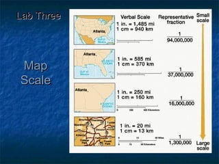
  • 18. Large Versus Small Scale Maps • Large scale maps refer to maps with a relatively large representative fraction such as 1/10,000. – Large scale maps show a small area of the Earth in great detail. • Small scale maps refer to maps with a relatively small representative fraction like 1/1,000,000. – Small scale maps show large areas in less detail. Small Scale Medium Scale Large Scale