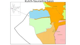
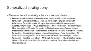
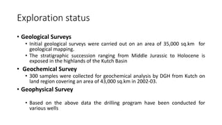
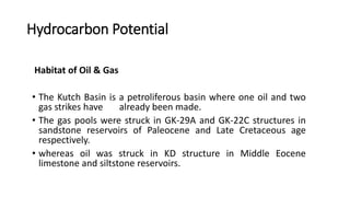
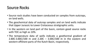
The document provides an overview of the Kutch Basin in India, including its geological history, stratigraphy, exploration status, and hydrocarbon potential. The basin formed during the breakup of eastern and western Gondwanaland and covers an area of 71,000 sq km. Exploration has found good source rocks and reservoirs capable of trapping hydrocarbons. Three discoveries have been made, indicating the basin is petroliferous. Future potential lies in fault-associated structures on land and deep-sea fan deposits offshore.
(MEERA) Dapodi Call Girls Just Call 7001035870 [ Cash on Delivery ] Pune Escorts
Basin Type and Hydrocarbon Accumulation in Kutch Basin
1. Basin Type and Hydrocarbon
Accumulation of KUTCH
BY
SYED NAWAZ
M-TECH 1ST SEM
PETROLEUM EXPLORATION AND PRODUCTION
DELTA STUDIES INSTITUTE, ANDHRA UNIVERSITY
2. Content
• Basin introduction
• Geological history
• Tectonic history
• Generalized stratigraphy
• Exploration status
• Hydrocarbon potential
• Conclusion
4. Basin introduction
• Basin formation is in northwestern portion of western continental margin
of India and is to be found at the southern edge of the Indus shelf at right
angles to the southern Indus fossil rift.
• It is bounded by the
• Nagar- Parkar fault in the North,
• Radhanpur-Barmer arch in the east and North Kathiawar fault towards the south.
• The basin extents between
• Latitude 22° 30' and 24° 30' N and
• Longitudes 68° and 72° E
And it covers the entire Kutch district and western part of Banaskantha districts
(Gujarat).
5. • Total area of a basin – 71000 sq.km from which
• Onland area is 43000sq.km
• Offshore area is 28000
• Bathymetry upto 200
• Sediments depositions
• 1500-2500m of Mesozoic sediments
• 550m of tertiary sediments
• 4500m of tertiary sediments in offshore region
• Sediments thickness
• North less 500m-4500m in south
• East 200m-14000m western part
• Western continental shelf break
• Depth-200m
• Width-300m (wide off Mumbai coast)
• Narrow down-160m (kutch in the north)
• Coastline indentations (2), in the southern and the northen parts of the basin,
• Gulf of kutch
• Kori creek
• Note : basin indicates the palaeo-slope in the south-west.
6. Geological history
• The evolution of the western continental-margin basins of India is due to
1- Breakup of eastern from western Gondwanaland
2- Spreading history of the eastern Indian ocean.
3- early and post rift phases of divergent margin
• Opening of Kutch basin to the north of Saurashtra peninsula coincided with
the transgressive phase of the sea onto the coastal areas of other parts of
Gondwanaland including the western margin of Indian plate during
Jurassic-Cretaceous time.
• In the region of Kutch basin, the structural differentiation between
• The shelfal horst-graben complex,
• The Kori-Comorin depression and
• The Kori-Comorin ridge.
7. Tectonic history
• The major portion of the Indian Peninsula is the Shield area with
intracratonic and pericratonic fault bounded basins and rest by volcanic
flow
• The three marginal basins of western India evolved in four stages
• Stage 1
• Kutch rifting along the Delhi trend
• Stage 2
• Kutch basin was filled up and the sea began recede
• Stage 3
• Extensive regional uplift in the western part of India.
• Stage 4
• The evolution of present continental margin shape of India
9. Exploration status
• Geological Surveys
• Initial geological surveys were carried out on an area of 35,000 sq.km for
geological mapping.
• The stratigraphic succession ranging from Middle Jurassic to Holocene is
exposed in the highlands of the Kutch Basin
• Geochemical Survey
• 300 samples were collected for geochemical analysis by DGH from Kutch on
land region covering an area of 43,000 sq.km in 2002-03.
• Geophysical Survey
• Based on the above data the drilling program have been conducted for
various wells
10. Hydrocarbon Potential
Habitat of Oil & Gas
• The Kutch Basin is a petroliferous basin where one oil and two
gas strikes have already been made.
• The gas pools were struck in GK-29A and GK-22C structures in
sandstone reservoirs of Paleocene and Late Cretaceous age
respectively.
• whereas oil was struck in KD structure in Middle Eocene
limestone and siltstone reservoirs.
11. Source Rocks
• Source rock studies have been conducted on samples from outcrops,
on land wells.
• The geochemical data of outcrop samples and on land wells indicate
that Upper Jurassic to Lower Cretaceous stratigraphic units.
• In the western on land part of the basin, contain good source rocks
with TOC as high as 10%.
• The temperature data of wells indicate a geothermal gradient of
2.80C-3.80C/100 m and 2.20C – 3.00C/100 m in the eastern and
western offshore parts of the Kutch Basin, respectively.
12. Reservoir Development
• All the five wells drilled in the on land part of the Kutch basin
reveal abundant sandstones developed in the stratigraphic
section ranging from late Jurassic to early cretaceous which
form extensive and excellent reservoirs with good permeability
and porosity ranging up to 34%.
• The sandstone reservoirs of the bhuj formation with porosity
ranging up to 25% have been encountered.
• In the deep-sea areas west of the Kori-Comorin ridge, a number
of features are observed on seismic sections which resemble
deep-sea fans.
13. Entrapment Conditions
• A few fault-associated anticlinal features have already been identified
in the on land part of the basin with the help of surface geological
data and sparse seismic information.
• Frequent cyclicity in sedimentation, particularly during Tertiary time,
provides ample facies variations; both laterally, and vertically.
• Thus there are adequate reservoir and cap rock, available to form
suitable entrapments
14. Conclusion
• The Kutch Basin is mainly a clastic basin and development of
limestone is noticed over Saurashtra arch and other paleo-highs.
• Limestone sequences of Eocene to Miocene age which attain
considerable thickness over Mumbai platform are found to be
shaling out in the Saurashtra depression.
• The tertiary sedimentary section is interrupted by several
unconformities