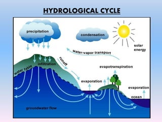
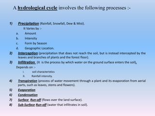
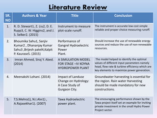
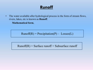
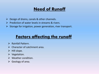
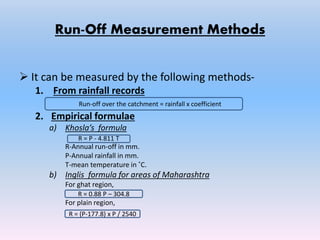
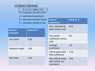
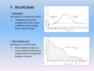
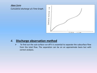
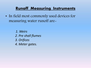
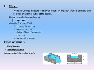
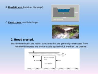
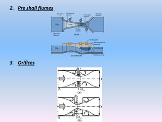
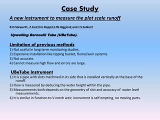
Hydrology.
Runoff Defn, need, Factors affecting runoff.
Runoff measurement methods.
Runoff measuring instruments.
Factors considered for site analysis.
Case study.
References.
CHARACTERISTICS OF WATERSHED: size, shape; physiography, slope, climate, drainage, land use, vegetation, geology and soils, hydrology and hydrogeology, socio-economic characteristics, basic data on watersheds.
Stream flow representing the runoff phase of the hydrologic cycle is the most important basic data for hydrologic studies. Runoff is generated by rainstorms. Its occurrence and quantity are dependent on the characteristics of the rainfall event, i.e. intensity, duration and distribution. This module highlights about runoff components of the hydrological cycle.
Hydrologic data generally consist of a sequence of observations of some phase of the hydrologic cycle made at a particular site. The data may be a record of the discharge of a stream at a particular place, or it may be a record of the amount of rainfall caught in a particular rain gage.
Although for most hydrologic purposes a long record is preferred to a short one, the user should recognize that the longer the record the greater the chance that there has been a change in the physical conditions of the basin or in the methods of data collection. If these are appreciable, the composite record would represent only a nonexistent condition and not one that existed either before or after the change. Such a record is inconsistent.
It is a topic from Engineering Hydrology authored by Raghunath. It was my report when I took up this subject on 2nd semester, 2014-2015 during my 4th year level. It was under my instructor, Engr. Bernadeth V. Dapun, MERIE
Flood has a great role in the socioeconomic status of the community living in the sourrounding of the river. How to analyze and manage the flood water is a real issue facing throughout the world specially in the developing countries. Unit Hydrograph play a vital role in predicting and analyzing the watershed water.
Sufficiency of water distributory(hlbc)eSAT Journals
Abstract
It is known fact that India has a very large population and different studies show that it will continue to rise. The precipitation in
India is extremely conflicting in mainstream varieties. The normal yearly precipitation for India has been assessed at 1,143 mm
for the actual surviving of the nation, there is a good requirement for actualizing and arrangement of watering system procedures
for the time being, and in the future. The present condition of canal and present cropping pattern, water is insufficient for the
designed command area. In this method both discharge & crop requirement is considered. Hence for improving the irrigating
capacity of canal, designed cropping pattern should be strictly followed. Increased pipe outlets should be reduced to its design
size. Also uncontrolled pipe outlets should be controlled by suitable controlling methods for determining the sufficiency of water
distributory. In order to determine the sufficiency of water, a distributory (D-65) in Hemavathi canal system is considered which
runs for a length of 26.675 km having command area 4703.08 Ha. Crop water requirement by Duty method & Modified Penman’s
Equation of discharge through outlets is used for determining sufficiency of water. Climatic data for Modified Penman’s method
is collected for a period of 5 year from K.R Pete Hydrometer logical station in this connection.
Key Words: Precipitation1, Cropping2, Distributory3 Controlling4 and Sufficiency5 .
Features:
View watershed boundary and drainage network, and contour map layers
Find area of a selected watershed
View ground profile along and across the stream path
View existing water conservation structures along with photo
Manage watershed structures
Add Water Conservation Structure
Change Status of Structure (Proposed, Under Progress, Completed)
Technology
Google Maps API
Google Elevation API
Google Fusion Tables (for polyline and polygon data)
ASP.NET, SQL Server 2008 (for point data)
This study explains the use of remote sensing data for spatially distributed hydrological modeling using the MIKE-SHE software used in Tarim River Basin CHINA
Water supply Engineering Notes by Sudip Khadka.pdfSudip khadka
branch of engineering concerned with the development of sources of supply, transmission, distribution, and treatment of water. The term is used most frequently for municipal water works, but applies also to water systems for industry, irrigation, wastewater reuse, and other purposes
Exploiting Artificial Intelligence for Empowering Researchers and Faculty, In...Dr. Vinod Kumar Kanvaria
Exploiting Artificial Intelligence for Empowering Researchers and Faculty,
International FDP on Fundamentals of Research in Social Sciences
at Integral University, Lucknow, 06.06.2024
By Dr. Vinod Kumar Kanvaria
Macroeconomics- Movie Location
This will be used as part of your Personal Professional Portfolio once graded.
Objective:
Prepare a presentation or a paper using research, basic comparative analysis, data organization and application of economic information. You will make an informed assessment of an economic climate outside of the United States to accomplish an entertainment industry objective.
Introduction to AI for Nonprofits with Tapp NetworkTechSoup
Dive into the world of AI! Experts Jon Hill and Tareq Monaur will guide you through AI's role in enhancing nonprofit websites and basic marketing strategies, making it easy to understand and apply.
2024.06.01 Introducing a competency framework for languag learning materials ...Sandy Millin
http://sandymillin.wordpress.com/iateflwebinar2024
Published classroom materials form the basis of syllabuses, drive teacher professional development, and have a potentially huge influence on learners, teachers and education systems. All teachers also create their own materials, whether a few sentences on a blackboard, a highly-structured fully-realised online course, or anything in between. Despite this, the knowledge and skills needed to create effective language learning materials are rarely part of teacher training, and are mostly learnt by trial and error.
Knowledge and skills frameworks, generally called competency frameworks, for ELT teachers, trainers and managers have existed for a few years now. However, until I created one for my MA dissertation, there wasn’t one drawing together what we need to know and do to be able to effectively produce language learning materials.
This webinar will introduce you to my framework, highlighting the key competencies I identified from my research. It will also show how anybody involved in language teaching (any language, not just English!), teacher training, managing schools or developing language learning materials can benefit from using the framework.
Unit 8 - Information and Communication Technology (Paper I).pdfThiyagu K
This slides describes the basic concepts of ICT, basics of Email, Emerging Technology and Digital Initiatives in Education. This presentations aligns with the UGC Paper I syllabus.
How to Make a Field invisible in Odoo 17Celine George
It is possible to hide or invisible some fields in odoo. Commonly using “invisible” attribute in the field definition to invisible the fields. This slide will show how to make a field invisible in odoo 17.
Read| The latest issue of The Challenger is here! We are thrilled to announce that our school paper has qualified for the NATIONAL SCHOOLS PRESS CONFERENCE (NSPC) 2024. Thank you for your unwavering support and trust. Dive into the stories that made us stand out!
This slide is special for master students (MIBS & MIFB) in UUM. Also useful for readers who are interested in the topic of contemporary Islamic banking.
Acetabularia Information For Class 9 .docxvaibhavrinwa19
Acetabularia acetabulum is a single-celled green alga that in its vegetative state is morphologically differentiated into a basal rhizoid and an axially elongated stalk, which bears whorls of branching hairs. The single diploid nucleus resides in the rhizoid.
A Strategic Approach: GenAI in EducationPeter Windle
Artificial Intelligence (AI) technologies such as Generative AI, Image Generators and Large Language Models have had a dramatic impact on teaching, learning and assessment over the past 18 months. The most immediate threat AI posed was to Academic Integrity with Higher Education Institutes (HEIs) focusing their efforts on combating the use of GenAI in assessment. Guidelines were developed for staff and students, policies put in place too. Innovative educators have forged paths in the use of Generative AI for teaching, learning and assessments leading to pockets of transformation springing up across HEIs, often with little or no top-down guidance, support or direction.
This Gasta posits a strategic approach to integrating AI into HEIs to prepare staff, students and the curriculum for an evolving world and workplace. We will highlight the advantages of working with these technologies beyond the realm of teaching, learning and assessment by considering prompt engineering skills, industry impact, curriculum changes, and the need for staff upskilling. In contrast, not engaging strategically with Generative AI poses risks, including falling behind peers, missed opportunities and failing to ensure our graduates remain employable. The rapid evolution of AI technologies necessitates a proactive and strategic approach if we are to remain relevant.
Model Attribute Check Company Auto PropertyCeline George
In Odoo, the multi-company feature allows you to manage multiple companies within a single Odoo database instance. Each company can have its own configurations while still sharing common resources such as products, customers, and suppliers.
Thesis Statement for students diagnonsed withADHD.ppt
Hydrology, Runoff methods & instruments, Site selection
1. Topic : Hydrology, Run-off Measurement Instruments &
Site Analysis.
GROUP MEMBERS :
1. SHANKAR SHEGADE
2. DINESH PATIL
3. RAVEEN RAMANAN
4. MAHESH YENNAM
5. ASHISH SINGH
2. Contents
Introduction-Hydrology.
Hydrological Cycle.
Literature Review
Runoff (Definition, Needs & Factors).
Runoff Measurement Methods.
Runoff measuring instruments.
Factors considered for Site Analysis of Hydro-Electric
power plants.
Case Study.
3. Introduction
• The science of hydrology deals with the occurrence and distribution
of water over and above the earth’s surface.
• Hydrology is that branch of physical science, which deals with the
origin, distribution, and properties of water of the earth.
• It deals with the transportation of water through the air, over the
ground surface and through the earth strata.
• The knowledge of hydrology is of basic importance in all walks of life
that involve the use and supply of water for any purpose what so
ever.
• Therefore the knowledge of hydrology is not only useful in the field
of engineering, but also in agriculture, forestry and other branches
of natural sciences.
5. A hydrological cycle involves the following processes :-
1) Precipitation (Rainfall, Snowfall, Dew & Mist).
It Varies by :-
a. Amount
b. Intensity
c. Form by Season
d. Geographic Location.
2) Interception (precipitation that does not reach the soil, but is instead intercepted by the
leaves and branches of plants and the forest floor).
3) Infiltration (It is the process by which water on the ground surface enters the soil).
Depends on :-
I. soil characteristics
II. Rainfall intensity.
4) Transpiration (process of water movement through a plant and its evaporation from aerial
parts, such as leaves, stems and flowers).
5) Evaporation
6) Condensation
7) Surface Run-off (flows over the land surface).
8) Sub-Surface Run-off (water that infiltrates in soil).
6. Literature Review
SR.
NO
Authors & Year Title Conclusion
1. R. D. Stewart1, Z. Liu2, D. E.
Rupp3, C. W. Higgins2, and J.
S. Selker2. (2015)
Instrument to measure
plot-scale runoff.
The instrument is accurate low cost simple
reliable and proper choice measuring runoff.
2. Bhoumika Sahu1, Sanjiv
Kumar2 , Dhananjay Kumar
Sahu3 ,Brijesh patel4,Kalpit
P. Kaurase5. (2015)
Performance of
Gangrel Hydroelectric
Power
Plant.
Should increase the use of renewable energy
sources and reduce the use of non-renewable
resources.
3. Imran Ahmed, Siraj Y. Abed.
(2014)
A SIMULATION MODEL
FOR STAGE –IV KOYNA
HYDROPOWER PLANT
The model helped to identify the optimal
values of different input parameters namely
head, flow rate & turbine efficiency which are
key elements to maximize power generation.
4. Meenakshi Lohani. (2014) Impact of Landuse
Change on Hydrology:
A Case Study of
Gurgaon City.
Groundwater harvesting is essential for
the region. Rain water Harvesting
should be made mandatory for new
constructions.
5. T.S.Mehra1), N.I.Alvi1) ,
A.Rajasekhar1). (2007)
Tawa Hydroelectric
power plant.
The encouraging performance shown by the
Tawa project itself set an example for inviting
private investment in the small Hydro Power
Project sector.
7. Runoff
• The water available after hydrological process in the form of stream flows,
rivers, lakes, etc is known as Runoff.
Mathematical form,
Runoff(R) = Precipitation(P) – Losses(L)
Runoff(R) = Surface runoff + Subsurface runoff
8. Need of Runoff
Design of drains, canals & other channels.
Prediction of water levels in streams & rivers.
Storage for irrigation, power generation, river transport.
Rainfall Pattern.
Character of catchment area.
Hill slope.
Vegetation.
Weather condition.
Geology of area.
Factors affecting the runoff
9. Run-Off Measurement Methods
It can be measured by the following methods-
1. From rainfall records
2. Empirical formulae
a) Khosla’s formula
R-Annual run-off in mm.
P-Annual rainfall in mm.
T-mean temperature in ˚C.
b) Inglis formula for areas of Maharashtra
For ghat region,
For plain region,
R = 0.88 P – 304.8
R = (P-177.8) x P / 2540
R = P - 4.811 T
Run-off over the catchment = rainfall x coefficient
10. c) Lacey’s formula
R = monsoon run-off in mm.
S = catchment area factor.
F = monsoon duration factor.
P = monsoon rainfall in mm.
Type of
catchment
Value of S
Flat, cultivated &
black cotton soils
0.25
Flat, partly
cultivated, various
soils
0.6
Average
catchment
1.0
Hills & place with
little cultivation
1.70
Very hilly & steep,
with hardly any
cultivation
3.45
Class of
monsoon
Value of F
Very short 0.50
Standard length 1.00
Very long 1.50
R = P / (1 + 3084 F / PS)
11. 3. Run-off curves
a. Hydrograph
(Discharge v/s Time(months) Graph)
It indicates the power
available from the stream
at different times of day,
week, month or year
b. Flow duration curve
(Discharge v/s Time(%) Graph)
Flow duration curves are
most useful for preliminary
studies and for comparison
between streams.
12. Mass Curve
Cumulative discharge v/s Time Graph.
4. Discharge observation method
To find out the sub-surface run-off it is essential to separate the subsurface flow
from the total flow. The separation can be on an approximate basis but with
correct analysis.
13. Runoff Measuring Instruments
• In field most commonly used devices for
measuring water runoff are-
1. Weirs
2. Pre shall flumes
3. Orifices
4. Meter gates.
14. 1. Weirs:
Weirs are used to measure the flow of runoff; an irrigation channel or discharged
of a well or channel outlet at the source.
Discharge can be Summarised as:
where Q = flow rate of fluid
C = constant for structure
L = width of the crest
H = height of head of water over
the crest
n = varies with structure.
Types of weirs :-
1. Sharp Crested:
A. Rectangular weir
(comparatively large discharge).
Q = CLHn
15. 2. Broad crested.
Broad crested weirs are robust structures that are generally constructed from
reinforced concrete and which usually span the full width of the channel.
B. Cipolletti weir (medium discharge).
C. V-notch weir (small discharge).
17. Factors considered for Site Analysis of
Hydro-Electric power plants
1. Availability of water
– All other designs are based on it.
– Estimate should be made about the average quantity of water available throughout the year and
also about maximum and minimum quantity of water available during the year.
– These details are necessary to decide the capacity of the hydropower plant, and
– It also provide adequate spillways or gate relief during flood period.
2. Water storage
– Since there a is wide variation in rainfall during the year, therefore it is necessary to store the water
for continuous generation of power. The storage capacity can be calculated with the help of mass
curve.
– The two types of storages in use are
1. The storage is so constructed that it can make water available for power generation for one
year only.
2. Water is available in sufficient quantity even during the worst dry periods.
18. 3. Water head
– In order to generate a requisite quantity of power it is necessary that a large quantity of water at
sufficient head should be available.
– An increase in effective head for a given output, reduces the quantity of water required to be
supplied to the turbines.
4. Accessibility of site
– The site where hydro-electric plant is to be constructed should be easy accessible. This is important
if the electric power generated is to be utilized at or near the plant site.
– The site selected should have transportation facilities of rail and road.
5. Distance from the load centre
– Power plant should be set up near the load centre, this will reduce the cost of maintenance of
transmission line.
6. Type of the land of the site
– The land to be selected for the site should be cheap and rocky.
– The ideal site will be one where the dam will have largest catchment area to store water at high
head and will be economical in construction.
– Necessary requirement of the foundation rocks for masonry dam are-
• The rock should be strong enough to withstand the stresses transmitted from the dam
structure as well as the thrust of the water when the reservoir is full.
• The rock in the foundation of the dam should be reasonably impervious.
• The rock should remain stable under all conditions.
19. Case Study
A new instrument to measure the plot scale runoff
R.D.Stewart1, Z.Liu2,D.E.Rupp3,C.W.Higgins2,and J.S.Selker2
Upwelling Bernoulli Tube (UBeTube).
Limitation of previous methods
1) Not useful in long term monitoring studies.
2) Expensive installation like tipping bucket, flume/weir systems.
3) Not accurate.
4) Cannot measure high flow and errors are large.
UBeTube Instrument
1) It is a pipe with slots machined in its side that is installed vertically at the base of the
runoff.
2) Flow is measured by deducing the water height within the pipe.
3) Measurements both depends on the geometry of slot and accuracy of water level
measurements.
4) It is similar in function to V notch weir, instrument is self empting, no moving parts.
21. Construction and working
1) Consists of vertical 10cm diameter pipe, with slot machine at one end.
2) Material Used :- schedule 40 aluminum pipe (relatively low cost and
rigidity ,strength , resistance to corrosion.
3) The tube is attached to the bottom of the runoff plot.
4) Runoff system piping can be buried below grade which secures the system.
5) Instrument can have variation in slots.
6) By finding the water height , inside pipe , flow rate is measured.
Measuring water height
1) Use here vented pressure transducer system.
2) 10 cm tube has range 0.3 to 300 L/min.
3) With correction factor the error are reduced less than 14.
Conclusion :- The instrument is accurate low cost simple reliable and
proper choice measuring runoff.
22. References
• Blair, A., Sanger, D., White, D., Holland, A. F., Vandiver, L.,Bowker, C., and
White, S. Quantifying and simulating storm water runoff in watersheds,
Hydro. Process., 28, 559–569, 2014.
• Blume, T., Zehe, E., Reusser, D. E., Iroumé, A., and Bronstert,
A.:Investigation of runoff generation in a pristine, poorly gauged
catchment in the Chilean Andes I: A multi-method experimental study,
Hydro. Process., 22, 3661–3675, 2008.
• Biswas, A.K.,History of Hydrology,Amer.Elsevier, New York,348 pp.,1970.
• Nehls, T., Nam Rim, Y., and Wessolek, G.: Technical note on measuring run-
off dynamics from pavements using a new device: the weighable tipping
bucket, Hydro. Earth Syst. Sci., 15, 1379–1386, doi:10.5194/hess-15-1379-
2011, 2011.
• Power System Engineering By R.K. Rajput