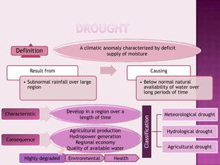
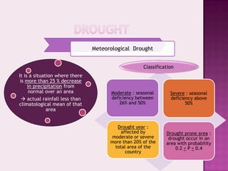
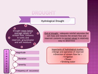
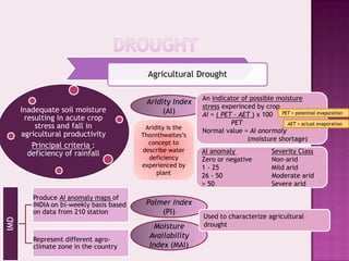
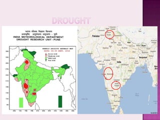
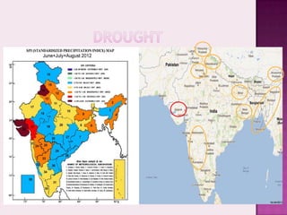
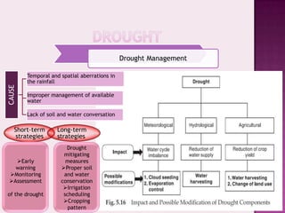
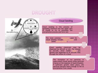
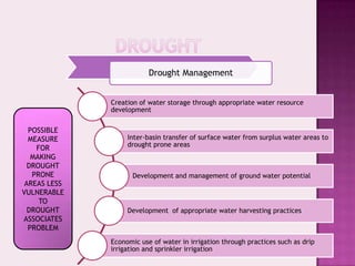
RUNOFF


                Prepared by:
SUZILAWATIE BT ABDUL GHANI
                    P 60832
Drought


Surface Water Resources of India
A climatic anomaly characterized by deficit
    Definition                               supply of moisture


           Result from                                                        Causing

        • Subnormal rainfall over large                    • Below normal natural
          region                                             availability of water over
                                                             long periods of time


Characteristic             Develop in a region over a
                                                                                   Meteorological drought
                                length of time


                                                             Classification
                            Agricultural production                                 Hydrological drought
                            Hydropower generation
Consequence
                              Regional economy
                           Quality of available water                                   Agricultural drought

        Highly degraded     Environmental       Health
Meteorological Drought


                                                    Classification
It is a situation where there
 is more than 25 % decrease
     in precipitation from
      normal over an area             Moderate : seasonal       Severe : seasonal
   actual rainfall less than         deficiency between        deficiency above
climatological mean of that               26% and 50%                  50%
              area


                                        Drought year :
                                          affected by         Drought prone area :
                                      moderate or severe       drought occur in an
                                      more than 20% of the    area with probability
                                       total area of the          0.2 < P < 0.4
                                            country
Hydrological Drought


      Drought mean below
       average values of           End of drought : adequate rainfall saturates the
     stream flow, contents            soil mass and restores the stream flow and
          in tanks and             reservoir contents to normal values is relatively
    reservoir, groundwater                        easy to determine
        and soil moisture


                                          Importants of hydrological studies:
C                                         Design and operation of reservoir
        Magnitude
O                                          Diversion of stream flow for :-
M                                                    Irrigation
P         Duration                                     Power
O                                                 Drinking water
N         Severity
E
N
T       Frequency of occurance
Agricultural Drought

                                                            An indicator of possible moisture
                                           Aridity Index
                                                            stress experinced by crop
      Inadequate soil moisture                  (AI)        AI = ( PET – AET ) x 100 PET = potential evaporation
       resulting in acute crop
                                                                      PET               AET = actual evaporation
          stress and fall in               Aridity is the
                                                            Normal value = AI anormaly
      agricultural productivity           Thornthwaites’s
                                                                           (moisture shortage)
         Principal criteria :               concept to
                                          describe water    AI anomaly               Severity Class
        deficiency of rainfall
                                            deficiency      Zero or negative         Non-arid
                                          experienced by    1 - 25                   Mild arid
                                               plant        26 - 50                  Moderate arid
                                                            > 50                     Severe arid

         Produce AI anomaly maps of
         INDIA on bi-weekly basis based    Palmer Index
         on data from 210 station              (PI)
                                                            Used to characterize agricultural
IMD


                                             Moisture       drought

         Represent different agro-
                                            Availability
         climate zone in the country        Index (MAI)
Drought Management

        Temporal and spatial aberrations in
        the rainfall
CAUSE


        Improper management of available
        water

        Lack of soil and water conversation

    Short-term      Long-term
     strategies     strategies
                       Drought
                      mitigating
   Early              measures
   warning           Proper soil
 Monitoring          and water
 Assessment         conservation
                      Irrigation
of the drought        scheduling
                      Cropping
                        pattern
Cloud Seeding

Cloud seeding is the process of
spreading chemical into the upper part
of clouds to try to stimulate the
precipitation process and form rain


    The most common chemicals used for
    cloud seeding include silver iodide and
    dry ice (solid carbon dioxide)


        Cloud seeding chemicals may be
        dispersed by aircraft or etc. For release
        by aircraft, silver iodide flares are
        ignited and dispersed as an aircraft flies
        through the inflow of a cloud


             The formation of ice particles in
             supercooled clouds allows those particles
             to grow at the expense of liquid droplets.
             If sufficient growth takes place, the
             particles become heavy enough to fall as
             precipitation from clouds
Drought Management


              Creation of water storage through appropriate water resource
              development

  POSSIBLE
  MEASURE          Inter-basin transfer of surface water from surplus water areas to
                   drought prone areas
    FOR
   MAKING
  DROUGHT
   PRONE             Development and management of ground water potential
 AREAS LESS
VULNERABLE
     TO
  DROUGHT          Development of appropriate water harvesting practices
ASSOCIATES
  PROBLEM
              Economic use of water in irrigation through practices such as drip
              irrigation and sprinkler irrigation
Water Harvesting


      DEFINITION (FOA)

The process of collecting and
  concentrating runoff water
from a runoff area into a run-
on area, where the collected
     water is either directly
 applied to the cropping area
 and stored in soil profile for
  immediate use by the crop
 (runoff farming or stored in
 an on-farm water reservoir)
   for future productive uses
    (domestic use, livestock
  watering, aquaculture and
           irrigation)
Roof Top Water Harvesting (RTWH)


 Definition        The productive utilization of rain water falling in roof-tops of structures
                   Urban area :- roof tops are impervious and occupy considerable land area

   Factor          Water supply :- inadequate , inefficient , unreliable

 Advantage         Economic


              Micro Catchment System (Within The Field) of Rainwater


                   System :- the catchment is small area - not put for any productive purpose
                   Length :- between 1 – 30 metres
                   During storm :- overland flow is harvested by collecting and delivering it to
Characteristic                      a small cultivated area
                   Ratio :- catchment to cultivated area = 1:1 to 3:1
                   Overflow :- no provision
Micro Catchment System (Within The Field) of Rainwater


        Negarim Micro Catchment

Dividing the catchment into a
large    number     of  micro
catchment in a diamond
pattern along the slope

   Each micro catchment is of
   square shape with a small
   earthen bunds at its boundary
   and an infiltration pit is
   provided at the lowest corner

      The pit is the cultivated area
      and usually a tree is grown in
      the pit

          The arrangement of micro
          catchment of sizes 10m^2 to
          100m^2
Macro Catchment System (Within The Field) of Rainwater


                 The system is designed for slightly larger catchment area where overland
 Definition      flow and rill flow is collected behind the bund allow to be stored in the soil
                 profile through infiltration


                  Length :- 30 to 200 m long
                  Ratio :- catchment to cultivated area = 2:1 to 10:1
                  Arrangement :- one row or two staggered rows of trapezoidal bunds with
Characteristic                       wing wall
                                   - contour bunds made a piled up stones
                  Overflow :- for disposing of the excess runoff water
                  Infiltration area :- use to grow crop
Floodwater Farming ( Floodwater Harvesting )

                                             Length :- several kilometres long
                           Characteristic
                                             Ratio :- catchment to cultivated area = larger than 10:1
                               Small structures are built across the drainage to   Check Dam               Nalabund
                               store part of the runoff

                               Store water : utilisable for community
Storage Structure System


                               Infiltration : recharge to the ground water
                               Advantages :- arresting erosion from the
                                              catchment
                               - prevent the deep and widen of gullies
                               Check Dams :- masonry overflow spillway                                   Cement Nalabund
                               - flanks : masonry / earthen embankment
                               - lower stream (up to 3) with median slope
                               Nalabunds :- across streams for impounding
                                           runoff flow to cause a small storage
                               - objective ~ improve water percolation
                                            ~ improve of soil moisture regime
                               - material ~ earthen embankment
                               - spillway ~ stone lined/rock cut steep channel
                               - construct ~ flat reach of a stream with
                                             slopes less than 2 %                                        Earthen Nalabund
Water Spreading
                     Diversion across the drainage would cause the runoff to flow on the
Spreading of Water


                     adjacent land. The water is forced to leave its natural course and
                     conveyed to nearby cropping fields

                     Appropriates bund cause spreading the water over the command

                     Spread water infiltrates into the soil and is retained as soil moisture

                     Provision for overflow spillway at the diversion structure, to pass
                     excess water onto the downstream side of the diversion
                     structure, IMPORTANT component of diversion structure


                                                            Drought in INDIA


                         Faced 29                               1918                           Affect
                       drought year                          – the worst                       –agriculture
                           since                                 year                          production
                        1875 -2004                         (70% effected)                      - economy
Surface Water Resource

In most of the basin of the country, the surface
      water resource have been develop

    Utilize through diversion structure and
                   reservoir

        Utilization produce return flow

   Definiton : non-comsumptive part of any
           diversion returned back

         Total Catchment Area (all river)
                  = 3.05 mil km

          Large : larger than 20,000 km^2


      Medium : between 20,000 to 2,000 km^2


               Small : less 2,000 km^2
Utilizable Water Resource

Definition    the quantum of water withdrawable from its place of natural occurrence

              topographic conditions
 Depend
              availability of land

              Not be possible to utilize entire surface water resource because:-
               - topography
               - environmental consideration
Limitation     - non-availability of suitable location
               - technology shortcoming
               - evaporation
               - percolation
Utilizable Water
           Resource


     CWC in 1988

Utilizable surface water
resource = 690.32 km^3
Utilizable Dynamic Groundwater Resource


                 Estimate by    CGWB

                                Total replenish-able water groundwater resources is 431.89 km^3/year


                                Utilizable dynamic groundwater potential is 396 km^3/year


                                       Water Available from Return Flow
Water Resource


                                                         Surface flow
                    Consumptive                                                          Due to
                                                                                economic, technology
                                        returned backs


                                                                              constraints and diminished
                                                         Groundwater system    water quality  part of
                     Non-Consumptive
                                                                              return flow is recoverable
                                                                                       for re-use
                                                         Soil moisture
Total Water Requirement

  Estimated by NCIWRD

Highest  Irrigation (68%)


        Evaporation

   Evaporation losses

     NCIWRD adopted
 - 15% of the live storage
capacity of major project
 - 25% of the live storage
capacity of minor project
Demand and Available
   Water Resources


The summary of NCIWRD
    study relating to
      national level
 assessment of demand
  and available water
        resource


    The return flow
 contributes 20-25% in
 reducing the demand
THANK YOU

Chapter 5 runoff

  • 1.
    RUNOFF Prepared by: SUZILAWATIE BT ABDUL GHANI P 60832
  • 2.
  • 3.
    A climatic anomalycharacterized by deficit Definition supply of moisture Result from Causing • Subnormal rainfall over large • Below normal natural region availability of water over long periods of time Characteristic Develop in a region over a Meteorological drought length of time Classification Agricultural production Hydrological drought Hydropower generation Consequence Regional economy Quality of available water Agricultural drought Highly degraded Environmental Health
  • 4.
    Meteorological Drought Classification It is a situation where there is more than 25 % decrease in precipitation from normal over an area Moderate : seasonal Severe : seasonal  actual rainfall less than deficiency between deficiency above climatological mean of that 26% and 50% 50% area Drought year : affected by Drought prone area : moderate or severe drought occur in an more than 20% of the area with probability total area of the 0.2 < P < 0.4 country
  • 5.
    Hydrological Drought Drought mean below average values of End of drought : adequate rainfall saturates the stream flow, contents soil mass and restores the stream flow and in tanks and reservoir contents to normal values is relatively reservoir, groundwater easy to determine and soil moisture Importants of hydrological studies: C Design and operation of reservoir Magnitude O Diversion of stream flow for :- M Irrigation P Duration Power O Drinking water N Severity E N T Frequency of occurance
  • 6.
    Agricultural Drought An indicator of possible moisture Aridity Index stress experinced by crop Inadequate soil moisture (AI) AI = ( PET – AET ) x 100 PET = potential evaporation resulting in acute crop PET AET = actual evaporation stress and fall in Aridity is the Normal value = AI anormaly agricultural productivity Thornthwaites’s (moisture shortage) Principal criteria : concept to describe water AI anomaly Severity Class deficiency of rainfall deficiency Zero or negative Non-arid experienced by 1 - 25 Mild arid plant 26 - 50 Moderate arid > 50 Severe arid Produce AI anomaly maps of INDIA on bi-weekly basis based Palmer Index on data from 210 station (PI) Used to characterize agricultural IMD Moisture drought Represent different agro- Availability climate zone in the country Index (MAI)
  • 9.
    Drought Management Temporal and spatial aberrations in the rainfall CAUSE Improper management of available water Lack of soil and water conversation Short-term Long-term strategies strategies Drought mitigating Early measures warning Proper soil Monitoring and water Assessment conservation Irrigation of the drought scheduling Cropping pattern
  • 10.
    Cloud Seeding Cloud seedingis the process of spreading chemical into the upper part of clouds to try to stimulate the precipitation process and form rain The most common chemicals used for cloud seeding include silver iodide and dry ice (solid carbon dioxide) Cloud seeding chemicals may be dispersed by aircraft or etc. For release by aircraft, silver iodide flares are ignited and dispersed as an aircraft flies through the inflow of a cloud The formation of ice particles in supercooled clouds allows those particles to grow at the expense of liquid droplets. If sufficient growth takes place, the particles become heavy enough to fall as precipitation from clouds
  • 11.
    Drought Management Creation of water storage through appropriate water resource development POSSIBLE MEASURE Inter-basin transfer of surface water from surplus water areas to drought prone areas FOR MAKING DROUGHT PRONE Development and management of ground water potential AREAS LESS VULNERABLE TO DROUGHT Development of appropriate water harvesting practices ASSOCIATES PROBLEM Economic use of water in irrigation through practices such as drip irrigation and sprinkler irrigation
  • 12.
    Water Harvesting DEFINITION (FOA) The process of collecting and concentrating runoff water from a runoff area into a run- on area, where the collected water is either directly applied to the cropping area and stored in soil profile for immediate use by the crop (runoff farming or stored in an on-farm water reservoir) for future productive uses (domestic use, livestock watering, aquaculture and irrigation)
  • 13.
    Roof Top WaterHarvesting (RTWH) Definition  The productive utilization of rain water falling in roof-tops of structures  Urban area :- roof tops are impervious and occupy considerable land area Factor  Water supply :- inadequate , inefficient , unreliable Advantage  Economic Micro Catchment System (Within The Field) of Rainwater  System :- the catchment is small area - not put for any productive purpose  Length :- between 1 – 30 metres  During storm :- overland flow is harvested by collecting and delivering it to Characteristic a small cultivated area  Ratio :- catchment to cultivated area = 1:1 to 3:1  Overflow :- no provision
  • 14.
    Micro Catchment System(Within The Field) of Rainwater Negarim Micro Catchment Dividing the catchment into a large number of micro catchment in a diamond pattern along the slope Each micro catchment is of square shape with a small earthen bunds at its boundary and an infiltration pit is provided at the lowest corner The pit is the cultivated area and usually a tree is grown in the pit The arrangement of micro catchment of sizes 10m^2 to 100m^2
  • 15.
    Macro Catchment System(Within The Field) of Rainwater The system is designed for slightly larger catchment area where overland Definition flow and rill flow is collected behind the bund allow to be stored in the soil profile through infiltration  Length :- 30 to 200 m long  Ratio :- catchment to cultivated area = 2:1 to 10:1  Arrangement :- one row or two staggered rows of trapezoidal bunds with Characteristic wing wall - contour bunds made a piled up stones  Overflow :- for disposing of the excess runoff water  Infiltration area :- use to grow crop
  • 16.
    Floodwater Farming (Floodwater Harvesting )  Length :- several kilometres long Characteristic  Ratio :- catchment to cultivated area = larger than 10:1 Small structures are built across the drainage to Check Dam Nalabund store part of the runoff Store water : utilisable for community Storage Structure System Infiltration : recharge to the ground water Advantages :- arresting erosion from the catchment - prevent the deep and widen of gullies Check Dams :- masonry overflow spillway Cement Nalabund - flanks : masonry / earthen embankment - lower stream (up to 3) with median slope Nalabunds :- across streams for impounding runoff flow to cause a small storage - objective ~ improve water percolation ~ improve of soil moisture regime - material ~ earthen embankment - spillway ~ stone lined/rock cut steep channel - construct ~ flat reach of a stream with slopes less than 2 % Earthen Nalabund
  • 17.
    Water Spreading Diversion across the drainage would cause the runoff to flow on the Spreading of Water adjacent land. The water is forced to leave its natural course and conveyed to nearby cropping fields Appropriates bund cause spreading the water over the command Spread water infiltrates into the soil and is retained as soil moisture Provision for overflow spillway at the diversion structure, to pass excess water onto the downstream side of the diversion structure, IMPORTANT component of diversion structure Drought in INDIA Faced 29 1918 Affect drought year – the worst –agriculture since year production 1875 -2004 (70% effected) - economy
  • 18.
    Surface Water Resource Inmost of the basin of the country, the surface water resource have been develop Utilize through diversion structure and reservoir Utilization produce return flow Definiton : non-comsumptive part of any diversion returned back Total Catchment Area (all river) = 3.05 mil km Large : larger than 20,000 km^2 Medium : between 20,000 to 2,000 km^2 Small : less 2,000 km^2
  • 19.
    Utilizable Water Resource Definition  the quantum of water withdrawable from its place of natural occurrence  topographic conditions Depend  availability of land  Not be possible to utilize entire surface water resource because:- - topography - environmental consideration Limitation - non-availability of suitable location - technology shortcoming - evaporation - percolation
  • 20.
    Utilizable Water Resource CWC in 1988 Utilizable surface water resource = 690.32 km^3
  • 21.
    Utilizable Dynamic GroundwaterResource Estimate by  CGWB  Total replenish-able water groundwater resources is 431.89 km^3/year  Utilizable dynamic groundwater potential is 396 km^3/year Water Available from Return Flow Water Resource Surface flow Consumptive Due to economic, technology returned backs constraints and diminished Groundwater system water quality  part of Non-Consumptive return flow is recoverable for re-use Soil moisture
  • 22.
    Total Water Requirement Estimated by NCIWRD Highest  Irrigation (68%) Evaporation Evaporation losses NCIWRD adopted - 15% of the live storage capacity of major project - 25% of the live storage capacity of minor project
  • 23.
    Demand and Available Water Resources The summary of NCIWRD study relating to national level assessment of demand and available water resource The return flow contributes 20-25% in reducing the demand
  • 24.