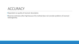
This document discusses methods for estimating hydrocarbon volumes in oil and gas accumulations, including deterministic and probabilistic volumetric estimation methods. Deterministic methods average reservoir property data from wells, cores, and seismic to estimate field-wide properties, while probabilistic methods use statistics and analog data to predict trends away from sample points. Accurate reserve estimates are important for evaluating an oil and gas company's value and longer-term prospects. The document provides terminology and formulas for calculating metrics like STOIIP and GIIP using data on reservoir area, thickness, porosity, water saturation, and gas formation volume factor.


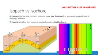
![Thickness (h) : the isochore thickness of the total interval ("gross thickness") regardless of
lithology.
An isochore map displays lines of equal thickness in a layer where the thicknesses are
measured vertically.
Isochore maps in geology are also referred to as True vertical Thickness (TVT) maps
Net sand : the height of the lithologic column with reservoir quality, i.e. the column that can
potentially store hydrocarbons.
NOS : the length of the net sand column that is oil bearing.
GRV : is the gross rock volume of the hydrocarbon-bearing interval and is the product of the
area (A) containing hydrocarbons and the interval thickness (h)
GRV =A . H
Units : ([ft3] or [acre.ft] or [m3])](https://image.slidesharecdn.com/14-200129051609/85/Hydrocarbon-estimation-methods-8-320.jpg)