Heightmaps intro
•
0 likes•38 views
This document discusses how to work with heightmaps, which are raster images used to store elevation data for 3D terrain modeling. Each pixel in a heightmap represents a height value. Heightmaps can be used for bump mapping, displacement mapping, and terrain modeling by converting the heightmap data into a 3D mesh. Heightmaps store elevation as grayscale values and can be created manually or algorithmically. They are commonly used in terrain software and video games to efficiently store terrain height data compared to polygonal meshes.
Report
Share
Report
Share
Download to read offline

Recommended
Global mapper tutorial Jimma University Ethiopia
This document discusses using Global Mapper software to delineate watersheds and calculate peak runoff for flood analysis. It provides an overview of common hydrological analysis methods for estimating maximum flood levels, and describes using the SCS unit hydrograph method within Global Mapper. It also outlines the basic steps and tools in Global Mapper for watershed delineation and peak runoff calculation.
Surfer software
This document discusses an assignment for a group project on using the software Surfer. It provides outlines on introducing Surfer, how to use it, and applications of Surfer such as creating contour maps, 3D surface maps, wireframe maps, vector maps, base maps, and map overlays. It also lists fields that use Surfer like hydrology, geology, archaeology, and surveying.
Making Beautiful Maps: Oct 5 2011
Presentation from Making Beautiful Maps
A Skillshare Class by Jake Levitas
At Gray Area Foundation for the Arts
Oct 5 2011
Geographical Information System (GIS) Georeferencing and Digitization, Bihar ...
This work is an effort to share Geographical Information System: Georeferencing, digitization and map making steps through QGIS 2.0.1
Georeferencing
Digitization of Topographical sheet
Point
Line
Area
Bihar Map
District Headquarters
Railway of Bihar
District Boundaries
Thematic Maps (Literacy & Sex Ratio)
Data Models - GIS I
GIS models reality through abstraction using a mix of raster, vector, and attribute data tailored to specific functions. Topological vector models record shared geometries like points and lines only once, allowing features to be connected and ensuring integrity as changes propagate between related features. Object-oriented models represent real-world phenomena as interconnected objects with their own rules and relationships.
Maplat - Historical viewer technology that guarantees nonlinear bijective con...
1) The document introduces a historical map viewer technology called Maplat that allows nonlinear and bijective coordinate conversion without distortion of historical maps.
2) When switching between inaccurate historical maps and accurate maps in Maplat, coordinate conversion is done in real-time to perfectly fit the maps at the center point while maintaining scale and rotation of surrounding points.
3) This allows historical maps to be overlaid on accurate maps without damaging aesthetic value, and guarantees bijective conversion back to the original location when switching between maps repeatedly.
GIS Modeling
This document provides an overview of GIS modeling using ModelBuilder in ArcGIS. It defines static and dynamic modeling and explains why modeling is useful for reproducibility, workflow efficiency, and handling tasks that would be impractical for a user to perform manually. Modeling allows for repeat testing of hypotheses with different data. The document outlines how to create models in ModelBuilder using a drag-and-drop interface to link together geoprocessing tools into a workflow and provides examples of models used in practice. It notes that models can be exported as scripts for additional functionality like cursor-based analysis and internet access.
Image processing mca project in jalandhar
The document discusses image processing and provides an overview of key concepts. It defines image processing as processing or altering existing images in a desired manner. It also describes acquiring images, image types, color imaging, image displays, enhancement techniques, and software used for image processing like Adobe Photoshop. The document emphasizes that digital processing requires converting images to electrical signals that can be digitized and processed by a computer.
image processing project course ludhiana
e2 matrix provides IT consulting services to its customers. e2 matrix provides the flexible practices that enable companies to operate more efficiently and produce more value. We also offer a wide-range of technologies such as-
MATLAB
NS2
IMAGE PROCESSING
.NET
SOFTWARE TESTING
DATA MINING
NEURAL networks
HFSS
WEKA
ANDROID
CLOUD computing
COMPUTER NETWORKS
FUZZY LOGIC
ARTIFICIAL INTELLIGENCE
LABVIEW
EMBEDDED
VLSI
We are professionals who are driven by the viewpoint of customer satisfaction through Quality and Innovation.
e2matrix believe in an open working relationship produces a positive and productive work environment that results in effective and low-cost solutions. We maximize the customer benefits by bringing the most pioneering solutions.
Address-Opp. Phagwara Bus Stand, Above Bella
Pizza, Handa City Center, Phagwara,punjab
email addres-e2matrixphagwara@gmail.com
jalandhare2matrix@gmail.com
WEBSITE-www.e2matrix.com
CONTACT NUMBER --
09041262727
07508509730
7508509709
Necto 16 training 7 geo-analytics
This document provides an overview of the Map component in Necto 16, including how to access and use the Map component, its key properties and functions, and the Map Designer tool. The Map component allows geospatial and hierarchical data to be visualized on base maps and templates for analysis. It is accessed from the Design ribbon and requires at least one geographic dimension. Properties include selecting dimensions, the basemap, template, and zooming functionality. The optional Map Designer further customizes maps.
What is gis
Geographic Information Systems (GIS) is a system that uses computer hardware, software, and personnel to analyze and present spatial information tied to locations. Key components of a GIS include geographic data about locations, information on attributes of those locations, software to store and process the data, hardware, and users. GIS brings together cartography, remote sensing, geography, and database technology to capture, store, analyze and display spatially-referenced data for the purposes of understanding relationships and patterns in that data. Common uses of GIS include applications in emergency services, environmental monitoring, business, government, education, and any field where the analysis of spatial data is important.
Dynamic Mapping of Raster Data (IV 2009)
The document proposes a method for dynamically mapping raster data onto 3D geovirtual environments using projective texture mapping. This allows for real-time visualization of large, time-critical geospatial datasets. By partially decoupling geometry and appearance, the method enables dynamic multi-texture mapping, color transfer functions, and rapid configuration of different mapping options. The approach extends graphics APIs like OpenGL to perform per-fragment dynamic texturing via shader programs. This achieves interactive framerates even with multiple texture mappings. The method is demonstrated through examples including hierarchical data layer combination, object highlighting, and interactive digital map design.
DTM DEM Generation
DTM/DEM generation involves creating digital models of terrain elevation from various data sources. A DTM provides height values referenced to positions and can include other terrain features, while a DEM only provides regular elevation values. Photogrammetry and remote sensing are common methods to acquire elevation data and generate DTMs/DEMs. The data often needs editing and filtering to remove errors and refine the models. Raster and TIN representations are common formats, with rasters using a grid and TINs using irregular triangles. Accuracy depends on factors like the data source and grid size for rasters. DSMs include above-ground features and require processing to derive bare earth DTMs below the features.
Georeferencing
Geo-referencing aligns raster or CAD data to a reference dataset with a known coordinate system. This process identifies control points visible in both datasets and links them, applying a transformation to align the original dataset to the reference. Geo-referencing can correct minor shifts or more drastic displacements. It saves transformation information in an external file or rectifies the data into the reference system. Spatial adjustment similarly aligns vector data during an edit session using transformation, edge-matching, or rubber sheeting methods based on control point links.
Cartographic map design
This document discusses topographic map design and layout. It begins with definitions of topographic maps and their typical contents, which include elevation, slope, land use, hydrographic features, and man-made structures. The presentation then covers the design process, including conceptualization, visualization, and construction of maps. Key aspects of design like legibility, visual contrast, figure-ground organization, and hierarchical structure are explained. The document concludes with discussions of map layout conventions and factors that influence effective design.
Assignment vector raster
Raster data consists of grids of cells that store values representing features like elevation or pixel color. Each cell has a single value and raster data can represent images through pixel color values. Raster data is stored in file formats like TIFF or directly in databases.
Vector data represents geographic features as points, lines, and polygons linked to attribute data. Points are zero-dimensional, lines are one-dimensional, and polygons are two-dimensional and can measure area. Vector data respects topological rules and can model continuously varying surfaces through techniques like contours and TINs. GIS tools allow users to perform tasks like buffering shapes, merging data, and clipping layers.
Map Design and Symbology in GIS Environment
This document discusses key principles of map design including selection of colors, symbols, labeling, and overall layout. It emphasizes that while there are scientific rules of map design, there is also an artistic element. The document outlines topics to be covered such as map scale and generalization, symbolization, choropleth mapping, use of color, and labeling. It provides guidelines for map elements like titles, legends, and orientation indicators. It also discusses classification schemes, issues with choropleth maps, effective use of color, and best practices for labeling and typography. Ethical practices of map design to avoid deception are highlighted.
Where2.0Now - Finding the heat in Thematic Maps
Thematic Mapping was once a specialist process for analysing statistical data spatially. GI Professionals understood how to do it, why they were doing and how to interpret the results. Thanks to the proliferation of API’s from the Web 2.0 world, Thematic Mapping API’s have become readily available and accessible by any developer with basic technical know how. You don’t have to be a GI Professional to create an impressive looking Thematic Map of your data. This presentation attempts to discuss how increased accessibility to geospatial processes is a good thing, BUT, you need to understand the underlying principles of geospatial analysis if you are going to leverage this technology
5 spatial data editing
This document discusses types of errors that can occur during spatial data editing and digitizing, including location errors, mechanical errors, human errors, and topological errors. It describes tools and processes for correcting errors such as CLEAN, nodesnap, editdistance, EXTEND, SPLIT, and edgematching. Both topological and non-topological editing approaches are covered.
Introduction to gis
This document provides an introduction to Geographic Information Systems (GIS) capabilities. It discusses how GIS has evolved from primarily managing vector data to now integrating imagery and raster data. A full-featured GIS system allows for 3D visualization, overlay of vector data on 3D surfaces, and production of maps incorporating various standard components like grids, scale bars, and legends. Interactive GIS functions allow users to select objects, view their attributes, and use attributes to select or style objects. Raster objects store cell values that represent features and are a fundamental component of modern GIS.
Digitization arc gis
1. The document provides steps to digitize features on a toposheet map using ArcGIS software.
2. It involves adding the toposheet and shapefile layers to the map, starting an editing session to create and edit features, and using tools to digitize point, line and polygon features by clicking vertices on the georeferenced map.
3. Attributes are then added to the digitized features by opening the attribute table and entering information in the respective fields.
Introduction to Infographics Designing
This document discusses how to create infographics using Adobe Illustrator. It defines infographics as visual representations of information designed to convey data quickly. Illustrator is recommended for infographic design because it allows for smaller file sizes, faster loading times, and effective data visualization through vector graphics that can be scaled without quality loss. The document outlines Illustrator's vector tools and environment which empower designers to convert raster images and text to editable vector points for customization across programs like Photoshop and InDesign, making it a powerful and versatile software for infographic creation.
Three dimensional (3D) GIS
3D GIS systems allow for modeling, representation, and analysis of spatial data in three dimensions. It extends traditional 2D GIS capabilities to incorporate depth information. 3D GIS faces challenges such as high data collection costs and developing formalisms for spatial analysis and relationships in 3D. While still specialized, 3D GIS has many applications and is being further developed by major GIS vendors and through integrating technologies like virtual reality.
Surfer
This document discusses contouring, gridding, and surface mapping techniques using Surfer software. It can generate maps quickly from irregularly spaced data by interpolating the values onto a regular grid. The grids can then be displayed and enhanced in Surfer by adding layers, customizing the view, and annotating to create publication-quality maps. Surfer allows users to interpolate irregular data into grids and generate different map types for understanding fields.
Web design: print to web
Presentation by Kenneth Field at International Cartographic Conference, Dresden 2013.
Much has been made about web maps being a new map-making medium even to the extent that they’re often referred to as a whole new breed of maps (e.g. intelligent web maps) or that they define a new paradigm in cartography. The democratization of map-making has certainly been pivotal in developing new ways of publishing maps and by new map-makers but cartography has always been a milieu defined by the varying dimensions of science, art and technology. The last of these has always been hugely defining and has gone a long way to determining how a map appears. Trends in ornate lettering were largely brought about by the skill of the copperplate engraver. Full colour map production was underpinned by developments in printing and digital map production technologies. Now, barriers to online map production have diminished; data has never been more easily gathered using mobile devices or acquired through online sources so making a map has never been easier in terms of their construction.
This is of huge consequence to the art of cartography. Technological development has been so rapid due to the perceived need to create a framework that allows anyone to make a map. What this has resulted in is more maps and, consequently, more bad maps. This paper does not seek to simply shine a light on the widespread abuse of maps brought about by recent change but, rather, to focus on an assessment of the way in which web mapping is both redefining and challenging cartography. I use a case study approach based on the parallel print and web production of a map designed to tell the story of deaths in Grand Canyon.
The Death in Grand Canyon map is the first of its kind to depict over 700 known deaths in the Grand Canyon. The purpose of the map was to catalogue the deaths spatially; to give them a locational context and to display the thematic information of the nature of the events of each death ranging from falls and drownings to snake bites, suicides and murders. Each death has a very individual story but collectively, they tell a bigger story of the danger that such a magnificent but dangerous environment poses to humans. The map was used as a vehicle to explicitly explore the differences between print and web as a publication medium and how the medium affects the design process.
The print map was designed as a large format poster; the web map as a multiscale information product for viewing on screen and mobile devices. Each was treated as a separate product and designed within the constraints and opportunities afforded by the two different production technologies. This paper explores how design principles and the use of different cartographic methods were largely driven by the different technologies of production and what they meant for how the story was to be communicated by each.
GIS in Geography
GIS allows users to visualize, analyze, and interpret geographic data by overlaying layers of information on maps. It integrates multiple datasets, performs spatial analyses like distance measurement, and creates maps, reports, and charts to reveal relationships within the data. GIS is widely used in fields like emergency response, transportation, and urban planning to more efficiently address problems and make informed decisions by viewing geographic patterns and trends.
Australia's Environment Explorer: Quick Tour
This document provides a tour of Australia's Environment Explorer, which allows users to view maps and charts about environmental data in Australia. It summarizes the key features including selecting map themes and types, using zoom and location tools, viewing regional or point data in charts, and accessing Street View imagery to see on-the-ground conditions. The tour demonstrates how to choose data years, regions, and map or data views to explore environmental information.
Terminology and Basic Questions About GIS
This document provides an overview of key concepts in GIS including shapefiles, grids, rasters, vectors, DEM, TIN, coordinate systems, and common file formats. It discusses the differences between raster and vector data, and explains that shapefiles are commonly used to store vector data while grids are used for raster data. DEM and TIN are introduced as methods for representing elevation data. The document also covers projected and unprojected coordinate systems and provides examples of coordinate systems. Common file formats for both raster and vector data are listed.
Fly thru
This document provides guidelines for creating 3D visualizations and fly-through movies in ArcScene to educate others about weed infestations. Key steps include defining an objective, assembling raster and DEM data, setting data frame and layer properties, inspecting the 3D scene, and exporting views and movies. Fly-through movies can be created by recording a camera track while flying through the scene or using a path from a shapefile.
Creating Slope-Enhanced Shaded Relief Using Global Mapper
Creating Slope-Enhanced Shaded Relief Maps Using Global Mapper
The document describes how to use Global Mapper software to create slope-enhanced shaded relief maps, which provide a better representation of terrain than traditional hillshade maps. The process involves [1] generating a hillshade map from a DEM, [2] creating a slope map from the DEM, and [3] combining the hillshade and slope maps using blending modes to remove gray shading from low-angle slopes. This enhances terrain details and improves visualization of thematic map colors. Examples demonstrate the superior results of slope-enhanced shaded relief maps for geologic mapping applications.
More Related Content
What's hot
image processing project course ludhiana
e2 matrix provides IT consulting services to its customers. e2 matrix provides the flexible practices that enable companies to operate more efficiently and produce more value. We also offer a wide-range of technologies such as-
MATLAB
NS2
IMAGE PROCESSING
.NET
SOFTWARE TESTING
DATA MINING
NEURAL networks
HFSS
WEKA
ANDROID
CLOUD computing
COMPUTER NETWORKS
FUZZY LOGIC
ARTIFICIAL INTELLIGENCE
LABVIEW
EMBEDDED
VLSI
We are professionals who are driven by the viewpoint of customer satisfaction through Quality and Innovation.
e2matrix believe in an open working relationship produces a positive and productive work environment that results in effective and low-cost solutions. We maximize the customer benefits by bringing the most pioneering solutions.
Address-Opp. Phagwara Bus Stand, Above Bella
Pizza, Handa City Center, Phagwara,punjab
email addres-e2matrixphagwara@gmail.com
jalandhare2matrix@gmail.com
WEBSITE-www.e2matrix.com
CONTACT NUMBER --
09041262727
07508509730
7508509709
Necto 16 training 7 geo-analytics
This document provides an overview of the Map component in Necto 16, including how to access and use the Map component, its key properties and functions, and the Map Designer tool. The Map component allows geospatial and hierarchical data to be visualized on base maps and templates for analysis. It is accessed from the Design ribbon and requires at least one geographic dimension. Properties include selecting dimensions, the basemap, template, and zooming functionality. The optional Map Designer further customizes maps.
What is gis
Geographic Information Systems (GIS) is a system that uses computer hardware, software, and personnel to analyze and present spatial information tied to locations. Key components of a GIS include geographic data about locations, information on attributes of those locations, software to store and process the data, hardware, and users. GIS brings together cartography, remote sensing, geography, and database technology to capture, store, analyze and display spatially-referenced data for the purposes of understanding relationships and patterns in that data. Common uses of GIS include applications in emergency services, environmental monitoring, business, government, education, and any field where the analysis of spatial data is important.
Dynamic Mapping of Raster Data (IV 2009)
The document proposes a method for dynamically mapping raster data onto 3D geovirtual environments using projective texture mapping. This allows for real-time visualization of large, time-critical geospatial datasets. By partially decoupling geometry and appearance, the method enables dynamic multi-texture mapping, color transfer functions, and rapid configuration of different mapping options. The approach extends graphics APIs like OpenGL to perform per-fragment dynamic texturing via shader programs. This achieves interactive framerates even with multiple texture mappings. The method is demonstrated through examples including hierarchical data layer combination, object highlighting, and interactive digital map design.
DTM DEM Generation
DTM/DEM generation involves creating digital models of terrain elevation from various data sources. A DTM provides height values referenced to positions and can include other terrain features, while a DEM only provides regular elevation values. Photogrammetry and remote sensing are common methods to acquire elevation data and generate DTMs/DEMs. The data often needs editing and filtering to remove errors and refine the models. Raster and TIN representations are common formats, with rasters using a grid and TINs using irregular triangles. Accuracy depends on factors like the data source and grid size for rasters. DSMs include above-ground features and require processing to derive bare earth DTMs below the features.
Georeferencing
Geo-referencing aligns raster or CAD data to a reference dataset with a known coordinate system. This process identifies control points visible in both datasets and links them, applying a transformation to align the original dataset to the reference. Geo-referencing can correct minor shifts or more drastic displacements. It saves transformation information in an external file or rectifies the data into the reference system. Spatial adjustment similarly aligns vector data during an edit session using transformation, edge-matching, or rubber sheeting methods based on control point links.
Cartographic map design
This document discusses topographic map design and layout. It begins with definitions of topographic maps and their typical contents, which include elevation, slope, land use, hydrographic features, and man-made structures. The presentation then covers the design process, including conceptualization, visualization, and construction of maps. Key aspects of design like legibility, visual contrast, figure-ground organization, and hierarchical structure are explained. The document concludes with discussions of map layout conventions and factors that influence effective design.
Assignment vector raster
Raster data consists of grids of cells that store values representing features like elevation or pixel color. Each cell has a single value and raster data can represent images through pixel color values. Raster data is stored in file formats like TIFF or directly in databases.
Vector data represents geographic features as points, lines, and polygons linked to attribute data. Points are zero-dimensional, lines are one-dimensional, and polygons are two-dimensional and can measure area. Vector data respects topological rules and can model continuously varying surfaces through techniques like contours and TINs. GIS tools allow users to perform tasks like buffering shapes, merging data, and clipping layers.
Map Design and Symbology in GIS Environment
This document discusses key principles of map design including selection of colors, symbols, labeling, and overall layout. It emphasizes that while there are scientific rules of map design, there is also an artistic element. The document outlines topics to be covered such as map scale and generalization, symbolization, choropleth mapping, use of color, and labeling. It provides guidelines for map elements like titles, legends, and orientation indicators. It also discusses classification schemes, issues with choropleth maps, effective use of color, and best practices for labeling and typography. Ethical practices of map design to avoid deception are highlighted.
Where2.0Now - Finding the heat in Thematic Maps
Thematic Mapping was once a specialist process for analysing statistical data spatially. GI Professionals understood how to do it, why they were doing and how to interpret the results. Thanks to the proliferation of API’s from the Web 2.0 world, Thematic Mapping API’s have become readily available and accessible by any developer with basic technical know how. You don’t have to be a GI Professional to create an impressive looking Thematic Map of your data. This presentation attempts to discuss how increased accessibility to geospatial processes is a good thing, BUT, you need to understand the underlying principles of geospatial analysis if you are going to leverage this technology
5 spatial data editing
This document discusses types of errors that can occur during spatial data editing and digitizing, including location errors, mechanical errors, human errors, and topological errors. It describes tools and processes for correcting errors such as CLEAN, nodesnap, editdistance, EXTEND, SPLIT, and edgematching. Both topological and non-topological editing approaches are covered.
Introduction to gis
This document provides an introduction to Geographic Information Systems (GIS) capabilities. It discusses how GIS has evolved from primarily managing vector data to now integrating imagery and raster data. A full-featured GIS system allows for 3D visualization, overlay of vector data on 3D surfaces, and production of maps incorporating various standard components like grids, scale bars, and legends. Interactive GIS functions allow users to select objects, view their attributes, and use attributes to select or style objects. Raster objects store cell values that represent features and are a fundamental component of modern GIS.
Digitization arc gis
1. The document provides steps to digitize features on a toposheet map using ArcGIS software.
2. It involves adding the toposheet and shapefile layers to the map, starting an editing session to create and edit features, and using tools to digitize point, line and polygon features by clicking vertices on the georeferenced map.
3. Attributes are then added to the digitized features by opening the attribute table and entering information in the respective fields.
Introduction to Infographics Designing
This document discusses how to create infographics using Adobe Illustrator. It defines infographics as visual representations of information designed to convey data quickly. Illustrator is recommended for infographic design because it allows for smaller file sizes, faster loading times, and effective data visualization through vector graphics that can be scaled without quality loss. The document outlines Illustrator's vector tools and environment which empower designers to convert raster images and text to editable vector points for customization across programs like Photoshop and InDesign, making it a powerful and versatile software for infographic creation.
Three dimensional (3D) GIS
3D GIS systems allow for modeling, representation, and analysis of spatial data in three dimensions. It extends traditional 2D GIS capabilities to incorporate depth information. 3D GIS faces challenges such as high data collection costs and developing formalisms for spatial analysis and relationships in 3D. While still specialized, 3D GIS has many applications and is being further developed by major GIS vendors and through integrating technologies like virtual reality.
Surfer
This document discusses contouring, gridding, and surface mapping techniques using Surfer software. It can generate maps quickly from irregularly spaced data by interpolating the values onto a regular grid. The grids can then be displayed and enhanced in Surfer by adding layers, customizing the view, and annotating to create publication-quality maps. Surfer allows users to interpolate irregular data into grids and generate different map types for understanding fields.
Web design: print to web
Presentation by Kenneth Field at International Cartographic Conference, Dresden 2013.
Much has been made about web maps being a new map-making medium even to the extent that they’re often referred to as a whole new breed of maps (e.g. intelligent web maps) or that they define a new paradigm in cartography. The democratization of map-making has certainly been pivotal in developing new ways of publishing maps and by new map-makers but cartography has always been a milieu defined by the varying dimensions of science, art and technology. The last of these has always been hugely defining and has gone a long way to determining how a map appears. Trends in ornate lettering were largely brought about by the skill of the copperplate engraver. Full colour map production was underpinned by developments in printing and digital map production technologies. Now, barriers to online map production have diminished; data has never been more easily gathered using mobile devices or acquired through online sources so making a map has never been easier in terms of their construction.
This is of huge consequence to the art of cartography. Technological development has been so rapid due to the perceived need to create a framework that allows anyone to make a map. What this has resulted in is more maps and, consequently, more bad maps. This paper does not seek to simply shine a light on the widespread abuse of maps brought about by recent change but, rather, to focus on an assessment of the way in which web mapping is both redefining and challenging cartography. I use a case study approach based on the parallel print and web production of a map designed to tell the story of deaths in Grand Canyon.
The Death in Grand Canyon map is the first of its kind to depict over 700 known deaths in the Grand Canyon. The purpose of the map was to catalogue the deaths spatially; to give them a locational context and to display the thematic information of the nature of the events of each death ranging from falls and drownings to snake bites, suicides and murders. Each death has a very individual story but collectively, they tell a bigger story of the danger that such a magnificent but dangerous environment poses to humans. The map was used as a vehicle to explicitly explore the differences between print and web as a publication medium and how the medium affects the design process.
The print map was designed as a large format poster; the web map as a multiscale information product for viewing on screen and mobile devices. Each was treated as a separate product and designed within the constraints and opportunities afforded by the two different production technologies. This paper explores how design principles and the use of different cartographic methods were largely driven by the different technologies of production and what they meant for how the story was to be communicated by each.
GIS in Geography
GIS allows users to visualize, analyze, and interpret geographic data by overlaying layers of information on maps. It integrates multiple datasets, performs spatial analyses like distance measurement, and creates maps, reports, and charts to reveal relationships within the data. GIS is widely used in fields like emergency response, transportation, and urban planning to more efficiently address problems and make informed decisions by viewing geographic patterns and trends.
Australia's Environment Explorer: Quick Tour
This document provides a tour of Australia's Environment Explorer, which allows users to view maps and charts about environmental data in Australia. It summarizes the key features including selecting map themes and types, using zoom and location tools, viewing regional or point data in charts, and accessing Street View imagery to see on-the-ground conditions. The tour demonstrates how to choose data years, regions, and map or data views to explore environmental information.
Terminology and Basic Questions About GIS
This document provides an overview of key concepts in GIS including shapefiles, grids, rasters, vectors, DEM, TIN, coordinate systems, and common file formats. It discusses the differences between raster and vector data, and explains that shapefiles are commonly used to store vector data while grids are used for raster data. DEM and TIN are introduced as methods for representing elevation data. The document also covers projected and unprojected coordinate systems and provides examples of coordinate systems. Common file formats for both raster and vector data are listed.
What's hot (20)
Similar to Heightmaps intro
Fly thru
This document provides guidelines for creating 3D visualizations and fly-through movies in ArcScene to educate others about weed infestations. Key steps include defining an objective, assembling raster and DEM data, setting data frame and layer properties, inspecting the 3D scene, and exporting views and movies. Fly-through movies can be created by recording a camera track while flying through the scene or using a path from a shapefile.
Creating Slope-Enhanced Shaded Relief Using Global Mapper
Creating Slope-Enhanced Shaded Relief Maps Using Global Mapper
The document describes how to use Global Mapper software to create slope-enhanced shaded relief maps, which provide a better representation of terrain than traditional hillshade maps. The process involves [1] generating a hillshade map from a DEM, [2] creating a slope map from the DEM, and [3] combining the hillshade and slope maps using blending modes to remove gray shading from low-angle slopes. This enhances terrain details and improves visualization of thematic map colors. Examples demonstrate the superior results of slope-enhanced shaded relief maps for geologic mapping applications.
QGIS Training.pptx
This document provides an overview of using QGIS open source GIS software to load, manipulate, and classify geospatial data. It discusses loading data formats like shapefiles and geodatabases, exploring the QGIS interface, performing digitization and attribute editing, running topology rules to check for errors, and labeling layers to provide more information about mapped features. Exercises are demonstrated step-by-step to help users understand how to apply GIS theory and create basic maps in QGIS.
Powerpoint
The document discusses several common file formats for digital images and video. It describes the Tagged Image File Format (TIFF) which stores raster graphics with no loss of data. It also covers the Joint Photographic Experts Group (JPEG) format, which uses lossy compression well suited for photographs. Additional formats mentioned include Graphics Interchange Format (GIF) for small file sizes and transparent images, Portable Network Graphics (PNG) for lossless compression, and Motion Picture Experts Group (MPEG) formats for high quality video.
Terra formation control or how to move mountains
The new Uplift Model of terrain generation is generalized here and provides new possibilities for terra
formation control unlike previous fractal terrain generation methods. With the Uplift Model fine-grained
editing is possible allowing the designer to move mountains and small hills to more suitable locations
creating gaps or valleys or deep bays rather than only being able to accept the positions dictated by the
algorithm itself. Coupled with this is a compressed file storage format considerably smaller in size that the
traditional height field or height map storage requirements.
Introduction to Computer graphics
This document provides an overview of computer graphics concepts including:
- Definition and components of computer graphics
- SRGP (Simple Raster Graphics Package) for drawing shapes and handling basic interactions
- Raster graphics features like canvases, clipping, and copy pixel
- Limitations of SRGP
- Display technologies like raster scan displays, random scan displays, and video controllers
- Input devices for user interaction like locators, keyboards, and logical input/output
Prayas session cgi & cga by – soumalya nandy
Computer graphics is responsible for displaying art and image data effectively and beautifully to the user, and processing image data received from the physical world. The interaction and understanding of computers and interpretation of data has been made easier because of computer graphics. It have had a profound impact on many types of media and have revolutionized animation, movies and the video game industry.
Computer-generated imagery (CGI) is the application of computer graphics to create or contribute to images in art, printed media, video games, films, television programs, commercials, videos, and simulators. The visual scenes may be dynamic or static, and may be two-dimensional (2D), though the term "CGI" is most commonly used to refer to 3D computer graphics used for creating scenes or special effects in films and television.
Video games most often use real-time computer graphics (rarely referred to as CGI), but may also include pre-rendered "cut scenes" and intro movies that would be typical CGI applications.
Graphics pipelining
A complete lecture on graphics pipelining.
A very important concept that every graphics person should understand.
Mpwhelp Eng[1]
Mapwel is mapping software that allows users to create custom maps and upload them to GPS units. It supports importing files in various formats, automatically converting projections and datums, and includes tools for manual drawing, autovectorization of raster images, and uploading maps directly to GPS units. Mapwel aims to make the entire process of map creation for GPS as easy as possible in a single software tool.
Designing Great Web Maps
Esri's Aileen Buckley offers tips for designing great ArcGIS Online web maps and includes considerations for projections, fonts, colors, symbols, and more.
L3 cmp technicalfile_180911
The document provides information about various types of digital image formats including raster images, vector images, and file formats. It discusses key aspects of raster images such as how they represent images using pixels that store color data. It contrasts raster images with vector images which use geometric primitives and mathematical equations. It also briefly outlines some common file formats and color models used in digital images.
Normal Mapping / Computer Graphics - IK
Normal mapping is a technique used in 3D computer graphics to add detail to 3D models without increasing the number of polygons. It works by encoding normal vector information for light calculation into RGB texture maps. This allows more detailed surface shapes and lighting than would be possible with just the base polygon mesh. The technique was introduced in the late 1990s and became widely used in video games starting in the early 2000s as hardware accelerated shaders became available, enabling real-time normal mapping rendering. It provides a good quality to performance ratio for complex surface details.
Building story maps
This document provides guidance on creating effective story maps using ArcGIS. It discusses:
- What story maps are and how they bring spatial analysis to large audiences
- The basic components of story maps, which include maps, text, multimedia and interactivity
- A 5-step process for developing story maps: 1) developing a storyboard, 2) gathering data, 3) creating web maps, 4) sharing maps, and 5) publishing maps as apps using templates
- Best practices for each step such as choosing appropriate basemaps, assembling thematic layers, configuring pop-ups, and refining cartography for storytelling purposes
Introduction to gis and arc gis
A Geographic Information System (GIS) integrates hardware, software and data to capture, store, query, analyze and display spatially-referenced information. A GIS links location data to descriptive attributes and allows users to create, edit, analyze and display map information on a computer. Key GIS functions include capturing data, storing data in both vector and raster formats, querying data, analyzing spatial relationships between data sets, displaying data visually, and outputting results in various formats like maps, reports and graphs.
Data sources and input in GIS
Perhaps the most important component of a GIS is in the part of data used in GIS. The data for GIS can be derived from various sources. A wide variety of data sources exist for both spatial and attribute data.
GIS - Unit 3-1.pptx for geographical information systems
Scanners convert paper maps and images into digital formats by capturing individual pixels. Scanners work by using a sensor to detect light reflected off the document and assign values to pixels, forming a digital image. Common scanner types include flatbed, sheet-fed, and drum scanners. Scanning produces raster data files that store images as a grid of pixels. Common raster formats include TIFF, JPEG, and PNG. Vector data involves digitizing maps to extract geographic features as points, lines, and polygons with attributes. Digitizing is done manually using a digitizing tablet or heads-up on a computer screen.
Desktop Softwares for Unmanned Aerial Systems(UAS))
The document compares various desktop software used for processing data from unmanned aerial vehicles (UAVs). It provides a table comparing the major features and functionality of Pix4Dmapper, Agisoft Metashape, WebODM, and QGIS. These include outputs generated, ease of use, cost, support and limitations. It also provides guidance on choosing the best software by defining needs, researching options, trying demonstrations, considering costs, and getting recommendations from experts. Selecting the right software depends on the required processing capabilities, accuracy, compatibility and other factors listed.
Geographic information system
Definition of gis.
component of gis .
function of gis.
data structure,
uses of gis ,
geo-referencing.
Chapter 1 fundamentals of digital imaging
The document discusses key concepts in computer graphics including advantages such as creating abstract objects and animations. It describes applications like user interfaces, charts/graphs, CAD/CAM, and simulations. Key graphics concepts covered are pixels, bit depth, resolution, color models, and color management. Primary topics are the basics of digital images, including file size/dimensions, color representation, and human perception of luminance, hue, and saturation.
GIS in Nutshell
GIS (Geographic Information Systems) is a system that integrates hardware, software, and data to capture, store, analyze and display spatial or geographic data. It allows users to view, understand, question, interpret, and visualize data in many ways that reveal relationships, patterns, and trends. Key components of a GIS include hardware, software, data, people, and methods. The document then provides examples of each component and defines common GIS terms like cartography, data types, topology, and benefits of using GIS for spatial analysis and decision making.
Similar to Heightmaps intro (20)
Creating Slope-Enhanced Shaded Relief Using Global Mapper
Creating Slope-Enhanced Shaded Relief Using Global Mapper
GIS - Unit 3-1.pptx for geographical information systems
GIS - Unit 3-1.pptx for geographical information systems
Desktop Softwares for Unmanned Aerial Systems(UAS))
Desktop Softwares for Unmanned Aerial Systems(UAS))
More from VisCircle
Maruti omni
In dem folgenden Beitrag wird darüber berichtet, dass der Maruti Omni keinen 3D Konfigurator hat.
Caib 3d-tischlerei-konfigurator
In dem folgenden Artikel wird der 3D Tischlerei Konfigurator von CAIB vorgestellt.
3d brille-skalpell
In diesem Artikel wird erklärt, wie Augmented Reality erfolgreich in der Chirurgie eingesetzt wird.
Schmuck konfigurator-3d
In dem folgenden Artikel wird Ihnen ein 3D Konfigurator für Schmuck vorgestellt.
Honda konfigurator-3dmodellierung
In dem folgenden Artikel wird erläutert, wie Honda den 3D-Druck für seine zukünftigen Modelle einsetzt.
3d virtueller-showroom
In dem folgenden Beitrag präsentiert VisCircle den dreidimensionalen virtuellen Showroom von Tmall.
Virtual reality-architektur
In diesem Beitrag betont VisCircle die Bedeutung der Virtual Reality im Architekturwesen.
Kinemac 2-3d-animationen
In diesem Artikel erklärt Ihnen VisCircle, wie Sie mit Kinemac 2 für MacOS 3D Animationen erstellen können.
Augmented reality-realistisch
In diesem Artikel erklärt Ihnen VisCircle warum Augmented Reality eine sehr realistische Technologie ist.
Apple augmented-reality-brille
In diesem Beitrag berichtet VisCircle über die neue geplante AR-Brille von Apple. VisCircle ist eine auf 3D Konfiguratoren spezialisierte Agentur.
Herausforderungen produktkonfiguration
In diesem Artikel präsentiert VisCircle die Herausforderungen in der Produktkonfiguration. VisCircle ist eine auf 3D Konfiguratoren spezialisierte Agentur.
More from VisCircle (20)
Recently uploaded
How to Make Your Trade Show Booth Stand Out
Unlock the secrets to creating a standout trade show booth with our comprehensive guide from Blue Atlas Marketing! This presentation is packed with essential tips and innovative strategies to ensure your booth attracts attention, engages visitors, and drives business success. Whether you're a seasoned exhibitor or a first-timer, these expert insights will help you maximize your impact and make a memorable impression in a crowded exhibition hall. Learn how to:
Design an eye-catching and inviting booth
Incorporate interactive elements that engage visitors
Use effective branding and visuals to reinforce your message
Plan your booth layout for maximum traffic flow
Implement technology to enhance the visitor experience
Create memorable experiences that leave a lasting impression
Transform your trade show presence with these proven tactics and ensure your booth stands out from the competition. Download the PDF now and start planning your next successful exhibit!
How American Bath Group Leveraged Kontent
How American Bath Group Leveraged KontentDigiMarCon - Digital Marketing, Media and Advertising Conferences & Exhibitions
We will explore the transformative journey of American Bath Group as they transitioned from a traditional monolithic CMS to a dynamic, composable martech framework using Kontent.ai. Discover the strategic decisions, challenges, and key benefits realized through adopting a headless CMS approach. Learn how composable business models empower marketers with flexibility, speed, and integration capabilities, ultimately enhancing digital experiences and operational efficiency. This session is essential for marketers looking to understand the practical impacts and advantages of composable technology in today's digital landscape. Join us to gain valuable insights and actionable takeaways from a real-world implementation that redefines the boundaries of marketing technology.Efficient Website Management for Digital Marketing Pros
Learn how to optimize website projects, leverage SEO tactics effectively, and implement product-led marketing approaches for enhanced digital presence and ROI.
This session is your key to unlocking the secrets of successful digital marketing campaigns and maximizing your business's online potential.
Actionable tactics you can apply after this session:
- Streamlined Website Management: Discover techniques to streamline website development, manage day-to-day operations efficiently, and ensure smooth project execution.
- Effective SEO Practices: Gain valuable insights into optimizing your website for search engines, improving visibility, and driving organic traffic to your digital assets.
- Leverage Product-Led Marketing: Explore strategies for incorporating product-led marketing principles into your digital marketing efforts, enhancing user engagement and driving conversions.
Don't miss out on this opportunity to elevate your digital marketing game and achieve tangible results!
How To Navigate AI - The Future is Yours to Define - Tim Hayden
How To Navigate AI - The Future is Yours to Define - Tim HaydenDigiMarCon - Digital Marketing, Media and Advertising Conferences & Exhibitions
As 2023 proved, the next few years may be shaped by market volatility and artificial intelligence services such as OpenAI's ChatGPT and Perplexity.ai. Your brand will increasingly compete for attention with Google, Apple, OpenAI, and Amazon, and customers will expect a hyper-relevant and individualized experience from every business at any moment. New state-legislated data privacy laws and several FTC rules may challenge marketers to deliver contextually relevant customer experiences, much less reach unknown prospective buyers. Are you ready?Let's discuss the critical need for data governance and applied AI for your business rather than relying on public AI models. As AI permeates society and all industries, learn how to be future-ready, compliant, and confidentlyscaling growth.
Key Takeaways:
Primary Learning Objective
1: Grasp when artificial general intelligence (""AGI"") will arrive, and how your brand can navigate the consequences. Primary Learning Objective
2: Gain an accurate analysis of the continuously developing customer journey and business intelligence. Primary Learning Objective
3: Grow revenue at lower costs with more efficient marketing and business operations.Global Growth Starts With Translation - How To Unlock Global Markets - Tim Kirby
Global Growth Starts With Translation - How To Unlock Global Markets - Tim KirbyDigiMarCon - Digital Marketing, Media and Advertising Conferences & Exhibitions
Did you know that while 50% of content on the internet is in English, English only makes up 26% of the world’s spoken language? And yet 87% of customers won’t buy from an English only website.
Uncover the immense potential of communicating with customers in their own language and learn how translation holds the key to unlocking global growth. Join Smartling CEO, Bryan Murphy, as he reveals how translation software can streamline the translation process and seamlessly integrate into your martech stack for optimal efficiency. And that's not all – he’ll also share some inspiring success stories and practical tips that will turbocharge your multilingual marketing efforts!
Key takeaways:
1. The growth potential of reaching customers in their native language
2. Tips to streamline translation with software and integrations to your tech stack
3. Success stories from companies that have increased lead generation, doubled revenue, and more with translationDigital Marketing Trends - Experts Insights on How to Gain a Competitive Edge...
Digital Marketing Trends - Experts Insights on How to Gain a Competitive Edge...DigiMarCon - Digital Marketing, Media and Advertising Conferences & Exhibitions
The digital marketing industry is changing faster than ever and those who don’t adapt with the times are losing market share. Where should marketers be focusing their efforts? What strategies are the experts seeing get the best results? Get up-to-speed with the latest industry insights, trends and predictions for the future in this panel discussion with some leading digital marketing experts.Assignment 2 Task 1: Digital Marketing Course
How Consumers Use Technology And Its Impact On Their Lives
What’s “In” and “Out” for ABM in 2024: Plays That Help You Grow and Ones to L...
Delve into essential ABM ‘plays' that propel success while identifying and leaving behind tactics that no longer yield results. Led by ABM Experts, Jon Barcellos, Head of Solutions at Postal and Tom Keefe, Principal GTM Expert at Demandbase.
Mindfulness Techniques Cultivating Calm in a Chaotic World.pptx
In today’s fast-paced world, stress and anxiety have become common companions for many. With constant connectivity and an unending stream of information, finding moments of peace can seem like an insurmountable challenge. However, mindfulness techniques offer a beacon of calm amidst the chaos, helping individuals to center themselves and find balance. These practices, rooted in ancient traditions and supported by modern science, are accessible to everyone and can profoundly impact mental and emotional well-being.
Data-Driven Personalization - Build a Competitive Advantage by Knowing Your C...
Data-Driven Personalization - Build a Competitive Advantage by Knowing Your C...DigiMarCon - Digital Marketing, Media and Advertising Conferences & Exhibitions
Data-Driven Personalization: Build a Competitive Advantage by Knowing Your Customers Better Than Your Competitionjanani Digital Marketer|Digital Marketing consultant|Marketing Promotion|Coim...
Myself Janani Digital marketing consultant located in coimbatore I offer all kinds of digital marketing services for your business requirements such as SEO SMO SMM SMO CAMPAIGNS content writing web design for all your business needs with affordable cost
Digital Marketing Services | Techvolt Software :
Digital Marketing is a latest method of Marketing techniques widely used across the Globe. Digital Marketing is an online marketing technique and methods used for all products and services through Search Engine and Social media advertisements. Previously the marketing techniques were used without using the internet via direct and indirect marketing strategies such as advertising through Telemarketing,Newspapers,Televisions,Posters etc.
List of Services offered in Digital Marketing |Techvolt Software :
Techvolt Software offers best Digital Marketing services for promoting your products and services through online platform on the below methods of Digital marketing
1. Search Engine Optimization (SEO)
2. Search Engine Marketing (SEM)
3. Social Media Optimization (SMO)
4. Social Media Marketing (SMM)
5. Campaigns
Importance | Need of Digital Marketing (Online Promotions) :
1. Quick Promotions through Online
2. Generation of More leads and Business Enquiries via Search Engine and Social Media Platform
3. Latest Technology development vs Business promotions
4. Creation of Social Branding
5. Promotion with less investment
Benefits Digital Marketing Services at Techvolt software :
1. Services offered with Affordable cost
2. Free Content writing
3. Free Dynamic Website design*
4. Best combo offers on website Hosting,design along with digital marketing services
5. Assured Lead Generation through Search Engine and Social Media
6. Online Maintenance Support
Free Website + Digital Marketing Services
Techvolt Software offers Free website design for all customer and clients who is availing the digital marketing services for a minimum period of 6 months.
With Regards
Janani Digital Marketer
Coimbatore,Tamilnadu.
Boost Your Instagram Views Instantly Proven Free Strategies.
Supercars use advanced materials and tech for top-speed performance. Join Performance Car Exclusive to experience driving excellence.
https://instblast.com/instagram/free-instagram-views
Growth Marketing in 2024 - Randy Rayess, Outgrow
Growth Marketing in 2024 - Randy Rayess, OutgrowDigiMarCon - Digital Marketing, Media and Advertising Conferences & Exhibitions
Build marketing products across the customer journey to grow your business and build a relationship with your customer. For example you can build graders, calculators, quizzes, recommendations, chatbots or AR apps. Things like Hubspot's free marketing grader, Moz's site analyzer, VenturePact's mobile app cost calculator, new york times's dialect quiz, Ikea's AR app, L'Oreal's AR app and Nike's fitness apps. All of these examples are free tools that help drive engagement with your brand, build an audience and generate leads for your core business by adding value to a customer during a micro-moment.
Key Takeaways:
Learn how to use specific GPTs to help you Learn how to build your own marketing tools
Generate marketing ideas for your business How to think through and use AI in marketing
How AI changes the marketing gameLuxury Hanloom Saree Brand ,Capstone Project_Kiran Bansal.pdf
Capstone Project: Luxury Handloom Saree Brand
As part of my college project, I applied my learning in brand strategy to create a comprehensive project for a luxury handloom saree brand. Key aspects of this project included:
- *Competitor Analysis:* Conducted in-depth competitor analysis to identify market position and differentiation opportunities.
- *Target Audience:* Defined and segmented the target audience to tailor brand messages effectively.
- *Brand Strategy:* Developed a detailed brand strategy to enhance market presence and appeal.
- *Brand Perception:* Analyzed and shaped the brand perception to align with luxury and heritage values.
- *Brand Ladder:* Created a brand ladder to outline the brand's core values, benefits, and attributes.
- *Brand Architecture:* Established a cohesive brand architecture to ensure consistency across all brand touchpoints.
This project helped me gain practical experience in brand strategy, from research and analysis to strategic planning and implementation.
PickUp_conversational AI_Capex, Inc._20240610
PickUp, Improve conversions with scenario-based conversational AI.
Breaking Silos To Break Bank: Shattering The Divide Between Search And Social
At Mozcon 2024 I shared this deck on bridging the divide between search and social. We began by acknowledging that search-first marketers are used to different rules of engagement than social marketers. We also looked at how both channels treat creative, audiences, bidding/budgeting, and AI. We finished by going through how they can win together including UTM audits, harvesting comments from both to inform creative, and allowing for non-login forums to be part of your marketing strategy.
I themed this deck using Baldur's Gate 3 characters: Gale as Search and Astarion as Social
WTS-Berlin-2024-Veronika-Höller-Innovate-NextGEN-SEO-Merging-AI-Multimedia-an...
Dive deep into the cutting-edge strategies we're employing to revolutionize our web presence in the age of AI-driven search. As Gen Z reshapes the digital realm, discover how we can bridge the generational divide. Unlock the synergistic power of PPC, social media, and SEO, driving unparalleled revenues for our projects.
Mastering SEO for Google in the AI Era - Dennis Yu
Mastering SEO for Google in the AI Era - Dennis YuDigiMarCon - Digital Marketing, Media and Advertising Conferences & Exhibitions
Mastering Local SEO for Service Businesses in the AI Era"" is tailored specifically for local service providers like plumbers, dentists, and others seeking to dominate their local search landscape. This session delves into leveraging AI advancements to enhance your online visibility and search rankings through the Content Factory model, designed for creating high-impact, SEO-driven content. Discover the Dollar-a-Day advertising strategy, a cost-effective approach to boost your local SEO efforts and attract more customers with minimal investment. Gain practical insights on optimizing your online presence to meet the specific needs of local service seekers, ensuring your business not only appears but stands out in local searches. This concise, action-oriented workshop is your roadmap to navigating the complexities of digital marketing in the AI age, driving more leads, conversions, and ultimately, success for your local service business.
Key Takeaways:
Embrace AI for Local SEO: Learn to harness the power of AI technologies to optimize your website and content for local search. Understand the pivotal role AI plays in analyzing search trends and consumer behavior, enabling you to tailor your SEO strategies to meet the specific demands of your target local audience. Leverage the Content Factory Model: Discover the step-by-step process of creating SEO-optimized content at scale. This approach ensures a steady stream of high-quality content that engages local customers and boosts your search rankings. Get an action guide on implementing this model, complete with templates and scheduling strategies to maintain a consistent online presence. Maximize ROI with Dollar-a-Day Advertising: Dive into the cost-effective Dollar-a-Day advertising strategy that amplifies your visibility in local searches without breaking the bank. Learn how to strategically allocate your budget across platforms to target potential local customers effectively. The session includes an action guide on setting up, monitoring, and optimizing your ad campaigns to ensure maximum impact with minimal investment.Future-Proof Like Beyoncé - Syncing Email and Social Media for Iconic Brand L...
Future-Proof Like Beyoncé - Syncing Email and Social Media for Iconic Brand L...DigiMarCon - Digital Marketing, Media and Advertising Conferences & Exhibitions
In this dynamic session titled "Future-Proof Like Beyoncé: Syncing Email and Social Media for Iconic Brand Longevity," Carlos Gil, U.S. Brand Evangelist for GetResponse, unveils how to safeguard and elevate your digital marketing strategy. Explore how integrating email marketing with social media can not only increase your brand's reach but also secure its future in the ever-changing digital landscape. Carlos will share invaluable insights on developing a robust email list, leveraging data integration for targeted campaigns, and implementing AI tools to enhance cross-platform engagement. Attendees will learn how to maintain a consistent brand voice across all channels and adapt to platform changes proactively. This session is essential for marketers aiming to diversify their online presence and minimize dependence on any single platform. Join Carlos to discover how to turn social media followers into loyal email subscribers and ultimately, drive sustainable growth and revenue for your brand. By harnessing the best practices and innovative strategies discussed, you will be equipped to navigate the challenges of the digital age, ensuring your brand remains relevant and resonant with your audience, no matter the platform. Don’t miss this opportunity to transform your approach and achieve iconic brand longevity akin to Beyoncé's enduring influence in the entertainment industry.
Key Takeaways:
Integration of Email and Social Media: Understanding how to seamlessly integrate email marketing with social media efforts to expand reach and reinforce brand presence. Building a Robust Email List: Strategies for developing a strong email list that provides a direct line of communication to your audience, independent of social media algorithms. Data Integration for Targeted Campaigns: Leveraging combined data from email and social media to create personalized, targeted marketing campaigns that resonate with the audience. Utilization of AI Tools: Implementing AI and automation tools to enhance efficiency and effectiveness across marketing channels. Consistent Brand Voice Across Platforms: Maintaining a unified brand voice and message across all digital platforms to strengthen brand identity and user trust. Proactive Adaptation to Platform Changes: Staying ahead of social media platform changes and algorithm updates to keep engagement high and interactions meaningful. Conversion of Social Followers to Email Subscribers: Techniques to encourage social media followers to subscribe to email, ensuring a direct and consistent connection. Sustainable Growth and Minimized Platform Dependence: Strategies to diversify digital presence and reduce reliance on any single social media platform, thereby mitigating risks associated with platform volatility.Mastering SEO for Google in the AI Era - Dennis Yu
Mastering SEO for Google in the AI Era - Dennis YuDigiMarCon - Digital Marketing, Media and Advertising Conferences & Exhibitions
Mastering Local SEO for Service Businesses in the AI Era"" is tailored specifically for local service providers like plumbers, dentists, and others seeking to dominate their local search landscape. This session delves into leveraging AI advancements to enhance your online visibility and search rankings through the Content Factory model, designed for creating high-impact, SEO-driven content. Discover the Dollar-a-Day advertising strategy, a cost-effective approach to boost your local SEO efforts and attract more customers with minimal investment. Gain practical insights on optimizing your online presence to meet the specific needs of local service seekers, ensuring your business not only appears but stands out in local searches. This concise, action-oriented workshop is your roadmap to navigating the complexities of digital marketing in the AI age, driving more leads, conversions, and ultimately, success for your local service business.
Key Takeaways:
Embrace AI for Local SEO: Learn to harness the power of AI technologies to optimize your website and content for local search. Understand the pivotal role AI plays in analyzing search trends and consumer behavior, enabling you to tailor your SEO strategies to meet the specific demands of your target local audience. Leverage the Content Factory Model: Discover the step-by-step process of creating SEO-optimized content at scale. This approach ensures a steady stream of high-quality content that engages local customers and boosts your search rankings. Get an action guide on implementing this model, complete with templates and scheduling strategies to maintain a consistent online presence. Maximize ROI with Dollar-a-Day Advertising: Dive into the cost-effective Dollar-a-Day advertising strategy that amplifies your visibility in local searches without breaking the bank. Learn how to strategically allocate your budget across platforms to target potential local customers effectively. The session includes an action guide on setting up, monitoring, and optimizing your ad campaigns to ensure maximum impact with minimal investment.Recently uploaded (20)
Efficient Website Management for Digital Marketing Pros
Efficient Website Management for Digital Marketing Pros
How To Navigate AI - The Future is Yours to Define - Tim Hayden
How To Navigate AI - The Future is Yours to Define - Tim Hayden
Global Growth Starts With Translation - How To Unlock Global Markets - Tim Kirby
Global Growth Starts With Translation - How To Unlock Global Markets - Tim Kirby
Digital Marketing Trends - Experts Insights on How to Gain a Competitive Edge...
Digital Marketing Trends - Experts Insights on How to Gain a Competitive Edge...
What’s “In” and “Out” for ABM in 2024: Plays That Help You Grow and Ones to L...
What’s “In” and “Out” for ABM in 2024: Plays That Help You Grow and Ones to L...
Mindfulness Techniques Cultivating Calm in a Chaotic World.pptx
Mindfulness Techniques Cultivating Calm in a Chaotic World.pptx
Data-Driven Personalization - Build a Competitive Advantage by Knowing Your C...
Data-Driven Personalization - Build a Competitive Advantage by Knowing Your C...
janani Digital Marketer|Digital Marketing consultant|Marketing Promotion|Coim...
janani Digital Marketer|Digital Marketing consultant|Marketing Promotion|Coim...
Boost Your Instagram Views Instantly Proven Free Strategies.
Boost Your Instagram Views Instantly Proven Free Strategies.
Luxury Hanloom Saree Brand ,Capstone Project_Kiran Bansal.pdf
Luxury Hanloom Saree Brand ,Capstone Project_Kiran Bansal.pdf
Breaking Silos To Break Bank: Shattering The Divide Between Search And Social
Breaking Silos To Break Bank: Shattering The Divide Between Search And Social
WTS-Berlin-2024-Veronika-Höller-Innovate-NextGEN-SEO-Merging-AI-Multimedia-an...
WTS-Berlin-2024-Veronika-Höller-Innovate-NextGEN-SEO-Merging-AI-Multimedia-an...
Mastering SEO for Google in the AI Era - Dennis Yu
Mastering SEO for Google in the AI Era - Dennis Yu
Future-Proof Like Beyoncé - Syncing Email and Social Media for Iconic Brand L...
Future-Proof Like Beyoncé - Syncing Email and Social Media for Iconic Brand L...
Mastering SEO for Google in the AI Era - Dennis Yu
Mastering SEO for Google in the AI Era - Dennis Yu
Heightmaps intro
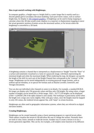
- 1. How to get started working with Heightmaps. In computer graphics, a height map or a height field is a raster image that is mainly used as a discrete global grid in secondary elevation modeling. Each pixel stores values, such as surface height data, for display in 3D computer graphics. A heightmap can be used in bump mapping to calculate where this 3D data would create shadows in a material, in displacement mapping to move the actual geometric position of points across the structured surface, or for terrain where the heightmap is converted to a 3D mesh. A heightmap contains a channel that is interpreted as a displacement or “height” from the “floor” of a surface and sometimes visualized as a lume of a grayscale image, with black representing the minimum height and white the maximum height. When rendering the map, the designer can specify the height of the shift for each unit of the Height Channel that corresponds to the “contrast” of the image. Heightmaps can be stored independently in existing grayscale image formats, with or without special metadata, or in special file formats such as Daylon Leveller, GenesisIV, and Terragen documents. You can also use individual color channels to zoom in on details. For example, a standard RGB-8- bit image can display only 256 grayscale values and thus only 256 heights. By using colors, a larger number of heights can be stored (for a 24-bit image, 2563 = 16,777,216 heights can be displayed (2564 = 4,294,967,296 if the alpha channel is also used)). This technique is particularly useful when the height over a large area varies slightly. Only with gray values, since the heights must be mapped to only 256 values, the rendered terrain appears flat, with “steps” at certain locations. Heightmaps are often used in geographic information systems, where they are referred to as digital elevation models. Creating Heightmaps. Heightmaps can be created manually using a classic painting program or a special terrain editor. These editors visualize the terrain in 3D and allow the user to change the surface. Normally there are tools to raise, lower, smooth or erode the terrain. Another way to create a terrain is to use a terrain generation algorithm. This can be, for example, a 2D simplex noise function or by diffusion
- 2. limited aggregation. Another method is the reconstruction of heightmaps from real data, e.g. with a synthetic aperture radar. Programs that use Heightmaps. Heightmaps are often used in terrain playback software and modern video games. Heightmaps are an ideal way to store digital terrain heights. Compared to a normal polygonal mesh, they require much less storage space at a certain level of detail. Most modern 3D computer modeling programs can use data from heightmaps in the form of bump, normal, or displacement maps to quickly and accurately create complex terrain and other surfaces. In the first games with software rendering, the elements often represented the heights of columns of voxels rendered with ray casting. In most recent games, the elements represent the height coordinate of polygons in a mesh. Thank you for visiting.