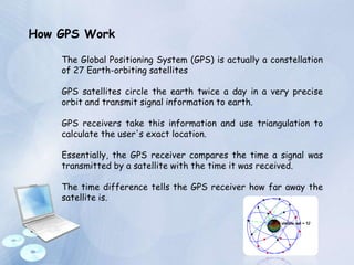
Global
Positioning
System
Presented by :
Trupti Kole
Introduction :
The Global Positioning System (GPS) is a satellite-based
navigation system , made up of a network of 24
satellites placed into orbit
In 1980s, it was developed by the United States
Department of Defense, and it is officially named
NAVSTAR GPS
GPS works in any weather conditions, anywhere in the
world, 24 hours a day.
There are no subscription fees or setup charges to use
GPS.
How GPS Work
The Global Positioning System (GPS) is actually a constellation
of 27 Earth-orbiting satellites
GPS satellites circle the earth twice a day in a very precise
orbit and transmit signal information to earth.
GPS receivers take this information and use triangulation to
calculate the user's exact location.
Essentially, the GPS receiver compares the time a signal was
transmitted by a satellite with the time it was received.
The time difference tells the GPS receiver how far away the
satellite is.
GPS Signals
What's the signal?
1. GPS satellites transmit two low power radio
signals, designated L1 and L2.
2. Civilian GPS uses the L1 frequency of 1575.42 MHz in the
UHF band.
3. The signals travel by line of sight, meaning they will pass
through clouds, glass and plastic but will not go through
most solid objects such as buildings and mountains.
What's the signal?
A GPS signal contains three different bits of information :-
 A pseudorandom code
 Ephemeris data
 Almanac data.
What's the signal?
1. The pseudorandom code is simply an I.D. code that
identifies which satellite is transmitting information.
2. Each satellite transmits ephemeris data showing the
orbital information for that satellite and for every other
satellite in the system.
3. Almanac data, which is constantly transmitted by each
satellite, contains important information about the status
of the satellite (healthy or unhealthy), current date and
time. This part of the signal is essential for determining a
position.
Sources of GPS signal errors
1. Ionosphere and troposphere delays
2. Signal multipath
3. Number of satellites visible
4. Orbital errors
5. Receiver clock errors
Elements of GPS
Elements of GPS :
GPS has three parts :-
 The space segment
 The user segment
 The control segment.
Elements of GPS :
A Constellation of Satellites
To make this measurement as accurate as possible, the
GPS navigation signals are specially designed to make it
easy for GPS receivers to measure the time of arrival and
to allow all the satellites to operate on the same frequency
without interfering with each other.
Receivers
GPS receivers can be carried in your hand or be installed
on aircraft, ships, tanks, submarines, cars, and trucks.
These receivers detect, decode, and process GPS satellite
signals. More than 100 different receiver models are
already in use
The GPS satellite system
1. The 24 satellites that make up the GPS space
segment are orbiting the earth about 12,000 miles
above us
2. They are constantly moving, making two complete
orbits in less than 24 hours.
3. These satellites are travelling at speeds of roughly
7,000 miles an hour.
The GPS satellite system
GPS satellites are powered by solar energy.
They have backup batteries onboard to keep them
running in the event of a solar eclipse, when
there's no solar power.
Small rocket boosters on each satellite keep them
flying in the correct path.
Best GPS Technology available in
Market
Garmin 880 Bluetooth Automotive
GPS System w/ MSN Direct &
Voice Recognition
The Garmin nüvi 880 features a
4.3-inch, 480-by-272-
pixel, WQVGA resolution screen.
There's built-in support for
Microsoft's MSN Direct service.
You also get a music player, an
Audible audiobook player, and a
picture viewer.
Microsoft Streets and Trips 2008 with GPS Locator
DVD
The #1 best-selling travel and map
software
A sleek Global Positioning System
(GPS) receiver that connects through
your computer’s USB port.
With Streets & Trips 2008 with GPS
Locator, you'll always know exactly
where you are.
Map your trip, plug the GPS receiver
into your laptop, and go!
All-in-one mobile PC with Microsoft Windows
XP operating system and built-in 12-channel
GPS
7" WVGA high-resolution LCD touch-screen
display;
Virtual keyboard makes it easy to access
settings and functions, type e-mails and take
notes
Preloaded Navteq base maps of the U.S. and
Canada
Built-in wireless LAN (802.11) and 10/100
Mbps Ethernet connectivity keeps you
connected to the Web for quick access to
Web browsing, e-mail, streaming media and
downloads
Jensen 7 Windows XP PRS Mini-Computer PC With GPS and
WiFi
Uses and Advantages
The Practical Uses of Global Positioning Systems
Personal Emergencies :
GPS equipped cell phones can transmit precise locations to
911 dispatchers. This allows the dispatcher to have an
immediate and accurate location instead of relying upon
descriptions of people who may be unfamiliar with the area
or too distraught to explain their location. The same
technology has also helped catch people who make crank 911
calls from their GPS-enabled cell phone.
The Practical Uses of Global Positioning Systems
Recreational Uses :
GPS is popular among
hikers, hunters, snowmobilers, mountain bikers, and cross-
country skiers. rails can be viewed on topographic map
software, traced on the screen and that route can be
downloaded into the GPS.
Tracking Your Kids: :
GPS-enabled cell phones can be used to monitor your kids.
Laptop GPS:
Laptop GPS receivers turn any mobile computer into a
fully functional GPS System. Save money and use a
laptop GPS receiver for in-vehicle, office based
meetings to track locations and find directions or
simply to plan a cycle ride for the next day.
Advantages of GPS technology
1. No More Maps by the Dozen!
2. Safer roads?
3. Money Saving
4. Less traffic?
Thank you

Gpa

  • 1.
  • 2.
    Introduction : The GlobalPositioning System (GPS) is a satellite-based navigation system , made up of a network of 24 satellites placed into orbit In 1980s, it was developed by the United States Department of Defense, and it is officially named NAVSTAR GPS GPS works in any weather conditions, anywhere in the world, 24 hours a day. There are no subscription fees or setup charges to use GPS.
  • 3.
    How GPS Work TheGlobal Positioning System (GPS) is actually a constellation of 27 Earth-orbiting satellites GPS satellites circle the earth twice a day in a very precise orbit and transmit signal information to earth. GPS receivers take this information and use triangulation to calculate the user's exact location. Essentially, the GPS receiver compares the time a signal was transmitted by a satellite with the time it was received. The time difference tells the GPS receiver how far away the satellite is.
  • 4.
  • 5.
    What's the signal? 1.GPS satellites transmit two low power radio signals, designated L1 and L2. 2. Civilian GPS uses the L1 frequency of 1575.42 MHz in the UHF band. 3. The signals travel by line of sight, meaning they will pass through clouds, glass and plastic but will not go through most solid objects such as buildings and mountains.
  • 6.
    What's the signal? AGPS signal contains three different bits of information :-  A pseudorandom code  Ephemeris data  Almanac data.
  • 7.
    What's the signal? 1.The pseudorandom code is simply an I.D. code that identifies which satellite is transmitting information. 2. Each satellite transmits ephemeris data showing the orbital information for that satellite and for every other satellite in the system. 3. Almanac data, which is constantly transmitted by each satellite, contains important information about the status of the satellite (healthy or unhealthy), current date and time. This part of the signal is essential for determining a position.
  • 8.
    Sources of GPSsignal errors 1. Ionosphere and troposphere delays 2. Signal multipath 3. Number of satellites visible 4. Orbital errors 5. Receiver clock errors
  • 9.
  • 10.
    Elements of GPS: GPS has three parts :-  The space segment  The user segment  The control segment.
  • 11.
    Elements of GPS: A Constellation of Satellites To make this measurement as accurate as possible, the GPS navigation signals are specially designed to make it easy for GPS receivers to measure the time of arrival and to allow all the satellites to operate on the same frequency without interfering with each other. Receivers GPS receivers can be carried in your hand or be installed on aircraft, ships, tanks, submarines, cars, and trucks. These receivers detect, decode, and process GPS satellite signals. More than 100 different receiver models are already in use
  • 12.
    The GPS satellitesystem 1. The 24 satellites that make up the GPS space segment are orbiting the earth about 12,000 miles above us 2. They are constantly moving, making two complete orbits in less than 24 hours. 3. These satellites are travelling at speeds of roughly 7,000 miles an hour.
  • 13.
    The GPS satellitesystem GPS satellites are powered by solar energy. They have backup batteries onboard to keep them running in the event of a solar eclipse, when there's no solar power. Small rocket boosters on each satellite keep them flying in the correct path.
  • 14.
    Best GPS Technologyavailable in Market Garmin 880 Bluetooth Automotive GPS System w/ MSN Direct & Voice Recognition The Garmin nüvi 880 features a 4.3-inch, 480-by-272- pixel, WQVGA resolution screen. There's built-in support for Microsoft's MSN Direct service. You also get a music player, an Audible audiobook player, and a picture viewer.
  • 15.
    Microsoft Streets andTrips 2008 with GPS Locator DVD The #1 best-selling travel and map software A sleek Global Positioning System (GPS) receiver that connects through your computer’s USB port. With Streets & Trips 2008 with GPS Locator, you'll always know exactly where you are. Map your trip, plug the GPS receiver into your laptop, and go!
  • 16.
    All-in-one mobile PCwith Microsoft Windows XP operating system and built-in 12-channel GPS 7" WVGA high-resolution LCD touch-screen display; Virtual keyboard makes it easy to access settings and functions, type e-mails and take notes Preloaded Navteq base maps of the U.S. and Canada Built-in wireless LAN (802.11) and 10/100 Mbps Ethernet connectivity keeps you connected to the Web for quick access to Web browsing, e-mail, streaming media and downloads Jensen 7 Windows XP PRS Mini-Computer PC With GPS and WiFi
  • 17.
  • 18.
    The Practical Usesof Global Positioning Systems Personal Emergencies : GPS equipped cell phones can transmit precise locations to 911 dispatchers. This allows the dispatcher to have an immediate and accurate location instead of relying upon descriptions of people who may be unfamiliar with the area or too distraught to explain their location. The same technology has also helped catch people who make crank 911 calls from their GPS-enabled cell phone.
  • 19.
    The Practical Usesof Global Positioning Systems Recreational Uses : GPS is popular among hikers, hunters, snowmobilers, mountain bikers, and cross- country skiers. rails can be viewed on topographic map software, traced on the screen and that route can be downloaded into the GPS. Tracking Your Kids: : GPS-enabled cell phones can be used to monitor your kids.
  • 20.
    Laptop GPS: Laptop GPSreceivers turn any mobile computer into a fully functional GPS System. Save money and use a laptop GPS receiver for in-vehicle, office based meetings to track locations and find directions or simply to plan a cycle ride for the next day.
  • 21.
    Advantages of GPStechnology 1. No More Maps by the Dozen! 2. Safer roads? 3. Money Saving 4. Less traffic?
  • 22.