Downloaded 41 times


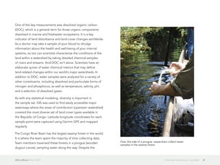
![GIS in Africa 2 April 2013 18Sustainability in Africa
there was unanimous consensus that the historical pattern of
resource exploitation has failed to promote sustained growth,
environmental integrity, and improved social capital and has,
even worse, been counterproductive. Second, they agreed that
the value of natural capital—the wealth of benefits provided to
people by biodiversity and ecosystems, like watersheds, forests,
coral reefs, and grasslands—must be fully accounted for and
integrated into national and corporate planning, as well as
reporting practices, policies, and programs.
The message resulting from the summit—the Gaborone
Declaration—reaffirmed a commitment to sustainability already
shared by these visionary leaders. The declaration signaled a new
era of leadership, rooted in Africa, that understands, values, and
manages the natural capital that sustains all of us: a platform on
which we can begin to build a sustainable future.
Summit participants included Sam Dryden, director of agricultural
development at the Bill & Melinda Gates Foundation; Laurene
Powell Jobs, chair and founder of Emerson Collective; Rachel
Kyte, vice president of sustainable development at the World
Bank; Rob Walton, the chairman of Walmart; and numerous other
private- and public-sector partners from within and outside Africa.
These participants also issued a communiqué to draw attention to
what they described as "the limitations of GDP [gross domestic
product] as a measure of well-being and sustainable growth that
values environmental and social aspects of progress."
In closing the summit, President Khama emphasized the
importance of following through on these commitments. "This
meeting will not be of any value to our peoples if we fail to
achieve the objectives that formed the core of this summit, that is,
integrating the value of natural capital into national and corporate
accounting and planning," he said. "We must continue building
social capital and reducing poverty by transitioning agriculture
and extractive industries to practices that promote sustainable
employment and the protection of natural capital while building
the knowledge, capacity, and policy networks needed to
promote leadership and increase momentum for change."
This is true leadership and an example we should celebrate and
follow.
The Gaborone Declaration marked an important step in paving
the way toward mutually beneficial partnerships between
governments and businesses. A month later, at Rio+20—the
United Nations Conference on Sustainable Development—these
10 African nations united under the Gaborone Declaration and
emerged as global leaders. They urged others to join them in
taking the first steps to correct what has been, up until now, a
misguided development trajectory. They were followed by
49 other nations, developed and developing alike, along with
nearly 100 public, private, and civil society partners, including
ArcelorMittal, the Coca-Cola Company, the Bill & Melinda Gates
Foundation, the German Development Institute, the MacArthur
Foundation, the United Nations Environment Programme, the](https://image.slidesharecdn.com/gis-in-africa-2-130524145147-phpapp02/85/GIS-in-Africa-2-19-320.jpg)
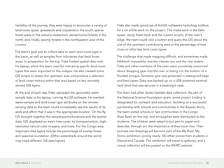
![GIS in Africa 2 April 2013 26Can GIS Help Fight the Spread of Malaria?
Can GIS Help Fight the Spread of Malaria?
Zambia Tries Out New Tactic on an Old Opponent
By Emmanuel Chanda, Victor Munyongwe Mukonka, David Mthembu,
Mulakwa Kamuliwo, Sarel Coetzer, and Cecilia Jill Shinondo
In Zambia, which is situated in southern Africa, malaria remains a
major cause of illness and mortality. Its transmission is driven by
a complex interaction between the vector (i.e., the mosquito that
transmits the disease), host, parasite, and the environment and
is governed by different ecological and social determinants. The
survival and adaptation of malaria vectors are affected by climate
variability, that is, variability in rainfall, temperature, and relative
humidity. As a result, even minute spatial variations and temporal
inconsistencies in the mosquito population can significantly
increase the risk of malaria.
Zambia has a population of approximately 12 million people,
45 percent of whom are under 15 years of age. Malaria is
endemic countrywide, and its transmission occurs throughout the
year, with a peak in the rainy season. The disease is the leading
cause of morbidity and mortality, accounting for 40 percent
of outpatients and 45 percent of hospital admissions, with
47 percent and 50 percent of disease burden, respectively,
among pregnant women and children under five years of age.
Current trends in the country indicate that malaria is responsible
for at least 3 million clinical cases and about 6,000 recorded
deaths annually, including up to 40 percent of the under-five
deaths and 20 percent of maternal mortality.
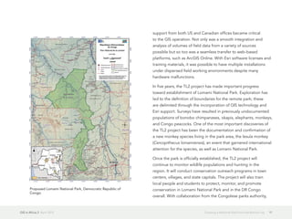
Since malaria is not evenly distributed, much effort needs to be
expended toward defining the local spatial distribution of the
disease before the deployment of vector control intervention
measures (i.e., indoor spraying and the distribution of insecticide-
treated nets [ITN]) in accordance with World Health Organization
(WHO) protocols. Furthermore, insecticide resistance is a growing
problem that must be factored into decisions.
However, in resource-constrained environments, monitoring and
evaluation are often neither thorough nor regular and tend to
lack the important spatial and temporal distribution patterns.
Therefore, if transmission-determining parameters are to be
harnessed effectively for decision making and objective planning,
implementing, monitoring, and evaluating viable options for
malaria vector control, those parameters must be well organized,
analyzed, and managed in the context of a GIS-based decision
support system (DSS).
The usefulness of an ArcGIS software-based DSS for planning
and managing control programs is, of course, dependent on the
availability of accurate and raw data on malaria transmission-
related parameters. The monitoring and evaluation of malaria
interventions and an understanding of their true impact on](https://image.slidesharecdn.com/gis-in-africa-2-130524145147-phpapp02/85/GIS-in-Africa-2-27-320.jpg)


The document discusses how GIS technology is helping to fight trachoma, the world's leading cause of preventable blindness. A new system uses smartphones and Esri software to collect data on trachoma prevalence in remote areas, transfer the data in real time to servers, and display the results on interactive maps. This helps identify communities in need of treatment and track progress towards eliminating trachoma globally by 2020. The system was tested in Ethiopia and provides an efficient way to gather and visualize geographic data on neglected tropical diseases.


![Getting Started with Apache Spark: Big Data Made Simple [Free Meetup]](https://cdn.slidesharecdn.com/ss_thumbnails/apachesparkgettingstarted-260203175547-8361bcc3-thumbnail.jpg?width=640&height=640&fit=bounds)


