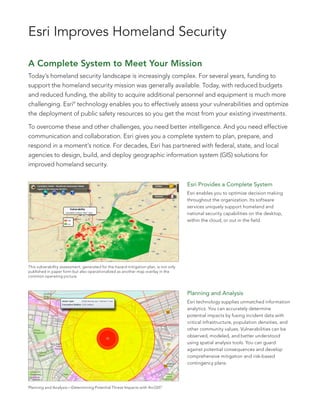
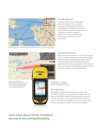
Esri Technology for Homeland Security
   ®
Esri Improves Homeland Security

A Complete System to Meet Your Mission
Today’s homeland security landscape is increasingly complex. For several years, funding to
support the homeland security mission was generally available. Today, with reduced budgets
and reduced funding, the ability to acquire additional personnel and equipment is much more
challenging. Esri® technology enables you to effectively assess your vulnerabilities and optimize
the deployment of public safety resources so you get the most from your existing investments.

To overcome these and other challenges, you need better intelligence. And you need effective
communication and collaboration. Esri gives you a complete system to plan, prepare, and
respond in a moment’s notice. For decades, Esri has partnered with federal, state, and local
agencies to design, build, and deploy geographic information system (GIS) solutions for
improved homeland security.


                                                                                       Esri Provides a Complete System
                                                                                       Esri enables you to optimize decision making
                                                                                       throughout the organization. Its software
                                                                                       services uniquely support homeland and
                                                                                       national security capabilities on the desktop,
                                                                                       within the cloud, or out in the field.


This vulnerability assessment, generated for the hazard mitigation plan, is not only
published in paper form but also operationalized as another map overlay in the
common operating picture.


                                                                                       Planning and Analysis
                                                                                       Esri technology supplies unmatched information
                                                                                       analytics. You can accurately determine
                                                                                       potential impacts by fusing incident data with
                                                                                       critical infrastructure, population densities, and
                                                                                       other community values. Vulnerabilities can be
                                                                                       observed, modeled, and better understood
                                                                                       using spatial analysis tools. You can guard
                                                                                       against potential consequences and develop
                                                                                       comprehensive mitigation and risk-based
                                                                                       contingency plans.


Planning and Analysis—Determining Potential Threat Impacts with ArcGIS®
Data Management
                                                                              You need to take volumes of disparate
                                                                              data and transform it into actionable
                                                                              information. GIS provides a standards-
                                                                              based platform that easily fits within your
                                                                              existing information technology structure.
                                                                              It gives you a powerful integration
                                                                              platform for storing and maintaining
                                                                              data using location as the common
                                                                              denominator.


Data Management—Bringing Data from Disparate Sources into a Common Viewer


                                                                              Situational Awareness
                                                                              Effective situational awareness means accessing real-
                                                                              time, secure information that’s continuously updated.
                                                                              GIS brings together multiple data streams (sensors,
                                                                              cameras, traffic, weather, incidents, etc.) using a
                                                                              geospatial interface to represent the current situation
                                                                              at any scale. You can quickly display, understand, and
                                                                              share vital intelligence for decision support.


Situational Awareness—
                                                                   Field Operations—Utilizing
Illustrating a Chemical Plume and
                                                                   Mobile Solutions in Connected
Identifying Road Closures and
                                                                   and Disconnected Environments
Critical Infrastructure with This
Common Operating Picture

                                                                   Field Operations
                                                                   GIS supplies mobile tools that enable you to get timely
                                                                   information anytime and anywhere and to rapidly push that
                                                                   data out to the field. Mobile GIS easily captures, sends, and
                                                                   receives information using a map-based common operating
                                                                   picture. Information is more effectively shared, and you have
                                                                   true interoperability for a safer, more effective response.


Learn more about GIS for homeland
security at esri.com/publicsafety.
About Esri                                                                                           Our Focus                                                                                     Contact Esri

Since 1969, Esri has been helping                                                                    Esri software is used by hundreds                                                             1 800 GIS XPRT (1 800 447 9778)
organizations map and model our                                                                      of thousands of organizations that                                                            t   909 793 2853
world. Esri’s GIS software tools                                                                     apply GIS to solve problems and                                                               f   909 793 5953
and methodologies enable these                                                                       make our world a better place to                                                              info@esri.com
organizations to effectively analyze                                                                 live. We pay close attention to our                                                           esri.com
and manage their geographic                                                                          users to ensure they have the best
                                                                                                                                                                                                   Offices worldwide
information and make better                                                                          tools possible to accomplish their
                                                                                                                                                                                                   esri.com/locations
decisions. They are supported by our                                                                 missions. A comprehensive suite of
experienced and knowledgeable staff                                                                  training options offered worldwide
and extensive network of business                                                                    helps our users fully leverage their
partners and international distributors.                                                             GIS applications.

A full-service GIS company, Esri                                                                     Esri is a socially conscious business,
supports the implementation of GIS                                                                   actively supporting organizations
technology on desktops, servers,                                                                     involved in education, conservation,
online services, and mobile devices.                                                                 sustainable development, and
These GIS solutions are flexible,                                                                    humanitarian affairs.
customizable, and easy to use.


                                                                          380 New York Street
                                                                          Redlands, California 92373-8100                                                usa


Copyright © 2011 Esri. All rights reserved. Esri, the Esri globe logo, ArcGIS, @esri.com, and esri.com are trademarks, registered trademarks, or service marks of Esri in the United States, the
European Community, or certain other jurisdictions. Other companies and products mentioned herein may be trademarks or registered trademarks of their respective trademark owners.

121802
ESRI04/11jb                                                                                                                                                                                                                          Printed in USA

Esri Technology for Homeland Security

  • 1.
    Esri Technology forHomeland Security ®
  • 2.
    Esri Improves HomelandSecurity A Complete System to Meet Your Mission Today’s homeland security landscape is increasingly complex. For several years, funding to support the homeland security mission was generally available. Today, with reduced budgets and reduced funding, the ability to acquire additional personnel and equipment is much more challenging. Esri® technology enables you to effectively assess your vulnerabilities and optimize the deployment of public safety resources so you get the most from your existing investments. To overcome these and other challenges, you need better intelligence. And you need effective communication and collaboration. Esri gives you a complete system to plan, prepare, and respond in a moment’s notice. For decades, Esri has partnered with federal, state, and local agencies to design, build, and deploy geographic information system (GIS) solutions for improved homeland security. Esri Provides a Complete System Esri enables you to optimize decision making throughout the organization. Its software services uniquely support homeland and national security capabilities on the desktop, within the cloud, or out in the field. This vulnerability assessment, generated for the hazard mitigation plan, is not only published in paper form but also operationalized as another map overlay in the common operating picture. Planning and Analysis Esri technology supplies unmatched information analytics. You can accurately determine potential impacts by fusing incident data with critical infrastructure, population densities, and other community values. Vulnerabilities can be observed, modeled, and better understood using spatial analysis tools. You can guard against potential consequences and develop comprehensive mitigation and risk-based contingency plans. Planning and Analysis—Determining Potential Threat Impacts with ArcGIS®
  • 3.
    Data Management You need to take volumes of disparate data and transform it into actionable information. GIS provides a standards- based platform that easily fits within your existing information technology structure. It gives you a powerful integration platform for storing and maintaining data using location as the common denominator. Data Management—Bringing Data from Disparate Sources into a Common Viewer Situational Awareness Effective situational awareness means accessing real- time, secure information that’s continuously updated. GIS brings together multiple data streams (sensors, cameras, traffic, weather, incidents, etc.) using a geospatial interface to represent the current situation at any scale. You can quickly display, understand, and share vital intelligence for decision support. Situational Awareness— Field Operations—Utilizing Illustrating a Chemical Plume and Mobile Solutions in Connected Identifying Road Closures and and Disconnected Environments Critical Infrastructure with This Common Operating Picture Field Operations GIS supplies mobile tools that enable you to get timely information anytime and anywhere and to rapidly push that data out to the field. Mobile GIS easily captures, sends, and receives information using a map-based common operating picture. Information is more effectively shared, and you have true interoperability for a safer, more effective response. Learn more about GIS for homeland security at esri.com/publicsafety.
  • 4.
    About Esri Our Focus Contact Esri Since 1969, Esri has been helping Esri software is used by hundreds 1 800 GIS XPRT (1 800 447 9778) organizations map and model our of thousands of organizations that t 909 793 2853 world. Esri’s GIS software tools apply GIS to solve problems and f 909 793 5953 and methodologies enable these make our world a better place to info@esri.com organizations to effectively analyze live. We pay close attention to our esri.com and manage their geographic users to ensure they have the best Offices worldwide information and make better tools possible to accomplish their esri.com/locations decisions. They are supported by our missions. A comprehensive suite of experienced and knowledgeable staff training options offered worldwide and extensive network of business helps our users fully leverage their partners and international distributors. GIS applications. A full-service GIS company, Esri Esri is a socially conscious business, supports the implementation of GIS actively supporting organizations technology on desktops, servers, involved in education, conservation, online services, and mobile devices. sustainable development, and These GIS solutions are flexible, humanitarian affairs. customizable, and easy to use. 380 New York Street Redlands, California 92373-8100 usa Copyright © 2011 Esri. All rights reserved. Esri, the Esri globe logo, ArcGIS, @esri.com, and esri.com are trademarks, registered trademarks, or service marks of Esri in the United States, the European Community, or certain other jurisdictions. Other companies and products mentioned herein may be trademarks or registered trademarks of their respective trademark owners. 121802 ESRI04/11jb Printed in USA