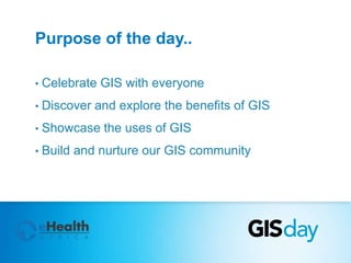
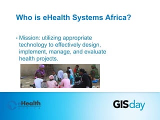
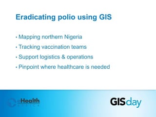
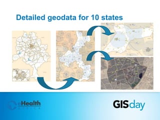
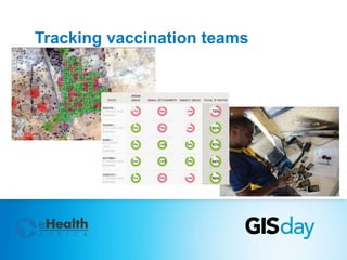
SlideShare a Scribd company logo
Welcome 
@ Kano’s first GIS Day!
GIS Day events around the world
Purpose of the day.. 
• Celebrate GIS with everyone 
• Discover and explore the benefits of GIS 
• Showcase the uses of GIS 
• Build and nurture our GIS community
Who is eHealth Systems Africa? 
• Mission: utilizing appropriate 
technology to effectively design, 
implement, manage, and evaluate 
health projects.
Agenda – Plenary sessions 
• Frank Salet: "Share your personal story“ 
• Oro-ghene Adia: "How Geospatial technology is transforming field data 
collection“ 
• Dr. Adamu Mustapha: "Application of multivariate Geostatistical analyses 
in environmental data“ 
• Dami Sonoiki: "General Trends in the Geospatial Industry“ 
• Owolabi Kazeem: "Direct Vaccine Delivery at your Doorstep"
Agenda - Activities 
• Map gallery 
• Poster presentations 
• Equipment demonstrations 
• Geography quiz 
• Sharing ideas and experiences
What is GIS? 
plus a brief history..
A way to explain GIS.. (1) 
Data 
Technology People
A way to explain GIS.. (2) 
Data 
collection & 
management 
Analysis Display
A way to explain GIS.. (3) 
Data Information Knowledge
Story maps 
Map-based storytelling is fun, compelling, and helps us all better 
understand our world.
Example story map – Ebola outbreaks 
Link: 
http://techsupportuk.maps. 
arcgis.com/apps/MapJourn 
al/?appid=deb9d5151d954 
de5b3933294c911b67f
Cholera outbreak – 1832, Paris
Cholera outbreak – 1854, London
John Snow’s data in modern day GIS..
Sharing your 
personal story
More personal 
stories..!
GIS, health & 
Nigeria
GIS in Africa 
Some figures (worldwide): 
• 270 Billion dollar value for 
GIS Industry 
• 9.6% Growth rate of GIS 
Market
GIS in (northern) Nigeria 
• Sustainable development 
• Plan for future events 
• Understand resources & 
human conditions
Eradicating polio using GIS 
• Mapping northern Nigeria 
• Tracking vaccination teams 
• Support logistics & operations 
• Pinpoint where healthcare is needed
Detailed geodata for 10 states
Tracking vaccination teams

More Related Content

What's hot

ESA Ramani Huria: Mapping for Flood Resilience, Fusing Remote Sensing and Com...
ESA Ramani Huria: Mapping for Flood Resilience, Fusing Remote Sensing and Com...ESA Ramani Huria: Mapping for Flood Resilience, Fusing Remote Sensing and Com...
ESA Ramani Huria: Mapping for Flood Resilience, Fusing Remote Sensing and Com...
Mark Iliffe
 
GIS Nordab Feb 2009
GIS Nordab Feb 2009GIS Nordab Feb 2009
GIS Nordab Feb 2009
pberry5082
 
GIS for Defence
GIS for DefenceGIS for Defence
GIS for Defence
IIC Technologies
 
GIS AND GPS
GIS AND GPSGIS AND GPS
GIS AND GPS
latshumi ganesan
 
Introduction to gis
Introduction to gisIntroduction to gis
Introduction to gis
Mohammad Adnan
 
GEOGRAPHICAL INFORMATION SYSTEM (GIS)
GEOGRAPHICAL INFORMATION SYSTEM (GIS)GEOGRAPHICAL INFORMATION SYSTEM (GIS)
GEOGRAPHICAL INFORMATION SYSTEM (GIS)
Siva Mbbs
 
Gis applications in tourism a tool for sustainable tourism
Gis applications in tourism  a tool for sustainable tourismGis applications in tourism  a tool for sustainable tourism
Gis applications in tourism a tool for sustainable tourism
pankaj kumar
 
Geographical Information System(GIS) in Urban Design
Geographical Information System(GIS) in Urban DesignGeographical Information System(GIS) in Urban Design
Geographical Information System(GIS) in Urban Design
Purushottam Uttarwar
 
Gis application in toursim
Gis application in toursimGis application in toursim
Gis application in toursim
Lydia Sitharthan
 
How Neogeography Killed GIS
How Neogeography Killed GISHow Neogeography Killed GIS
How Neogeography Killed GIS
Andrew Turner
 
Application of GIS
Application of GISApplication of GIS
Application of GIS
Rohit Pant
 
Spatial Technology Resources for Teachers
Spatial Technology Resources for TeachersSpatial Technology Resources for Teachers
Spatial Technology Resources for Teachers
Rebecca Nicholas
 
GIS for Urban Planning and Design
GIS for Urban Planning and DesignGIS for Urban Planning and Design
GIS for Urban Planning and Design
Anthony Smith
 
Call forpaper gs
Call forpaper gsCall forpaper gs
Call forpaper gs
Myung-Soon Kim
 
Using Spatial Technologies in the Geography Classroom
Using Spatial Technologies in the Geography ClassroomUsing Spatial Technologies in the Geography Classroom
Using Spatial Technologies in the Geography Classroom
Rebecca Nicholas
 
NCGE 2015 Web Maps
NCGE 2015 Web MapsNCGE 2015 Web Maps
NCGE 2015 Web Maps
Seth Dixon
 
Project presentation
Project presentationProject presentation
Project presentation
Arvind Kadam
 
Global positioning system
Global positioning systemGlobal positioning system
Global positioning system
Pushpraj Choudhary
 
GEOGRAPHIC INFORMATION SYSTEM (GIS) & REMOTE SENSING (RS)
GEOGRAPHIC  INFORMATION  SYSTEM (GIS)  & REMOTE SENSING  (RS)GEOGRAPHIC  INFORMATION  SYSTEM (GIS)  & REMOTE SENSING  (RS)
GEOGRAPHIC INFORMATION SYSTEM (GIS) & REMOTE SENSING (RS)
Harish kumar Lekkala
 
Map Kibera at YETAM training
Map Kibera at YETAM trainingMap Kibera at YETAM training
Map Kibera at YETAM training
jamielundine
 

What's hot (20)

ESA Ramani Huria: Mapping for Flood Resilience, Fusing Remote Sensing and Com...
ESA Ramani Huria: Mapping for Flood Resilience, Fusing Remote Sensing and Com...ESA Ramani Huria: Mapping for Flood Resilience, Fusing Remote Sensing and Com...
ESA Ramani Huria: Mapping for Flood Resilience, Fusing Remote Sensing and Com...
 
GIS Nordab Feb 2009
GIS Nordab Feb 2009GIS Nordab Feb 2009
GIS Nordab Feb 2009
 
GIS for Defence
GIS for DefenceGIS for Defence
GIS for Defence
 
GIS AND GPS
GIS AND GPSGIS AND GPS
GIS AND GPS
 
Introduction to gis
Introduction to gisIntroduction to gis
Introduction to gis
 
GEOGRAPHICAL INFORMATION SYSTEM (GIS)
GEOGRAPHICAL INFORMATION SYSTEM (GIS)GEOGRAPHICAL INFORMATION SYSTEM (GIS)
GEOGRAPHICAL INFORMATION SYSTEM (GIS)
 
Gis applications in tourism a tool for sustainable tourism
Gis applications in tourism  a tool for sustainable tourismGis applications in tourism  a tool for sustainable tourism
Gis applications in tourism a tool for sustainable tourism
 
Geographical Information System(GIS) in Urban Design
Geographical Information System(GIS) in Urban DesignGeographical Information System(GIS) in Urban Design
Geographical Information System(GIS) in Urban Design
 
Gis application in toursim
Gis application in toursimGis application in toursim
Gis application in toursim
 
How Neogeography Killed GIS
How Neogeography Killed GISHow Neogeography Killed GIS
How Neogeography Killed GIS
 
Application of GIS
Application of GISApplication of GIS
Application of GIS
 
Spatial Technology Resources for Teachers
Spatial Technology Resources for TeachersSpatial Technology Resources for Teachers
Spatial Technology Resources for Teachers
 
GIS for Urban Planning and Design
GIS for Urban Planning and DesignGIS for Urban Planning and Design
GIS for Urban Planning and Design
 
Call forpaper gs
Call forpaper gsCall forpaper gs
Call forpaper gs
 
Using Spatial Technologies in the Geography Classroom
Using Spatial Technologies in the Geography ClassroomUsing Spatial Technologies in the Geography Classroom
Using Spatial Technologies in the Geography Classroom
 
NCGE 2015 Web Maps
NCGE 2015 Web MapsNCGE 2015 Web Maps
NCGE 2015 Web Maps
 
Project presentation
Project presentationProject presentation
Project presentation
 
Global positioning system
Global positioning systemGlobal positioning system
Global positioning system
 
GEOGRAPHIC INFORMATION SYSTEM (GIS) & REMOTE SENSING (RS)
GEOGRAPHIC  INFORMATION  SYSTEM (GIS)  & REMOTE SENSING  (RS)GEOGRAPHIC  INFORMATION  SYSTEM (GIS)  & REMOTE SENSING  (RS)
GEOGRAPHIC INFORMATION SYSTEM (GIS) & REMOTE SENSING (RS)
 
Map Kibera at YETAM training
Map Kibera at YETAM trainingMap Kibera at YETAM training
Map Kibera at YETAM training
 

Similar to Kano GIS Day 2014 - Opening remarks

GIS in Health
GIS in HealthGIS in Health
GIS in Health
Ashwin Raj
 
Extreme Citizen Science: Current Development
Extreme Citizen Science: Current Development Extreme Citizen Science: Current Development
Extreme Citizen Science: Current Development
Muki Haklay
 
Data are the new oil: Big data, data mining and bio - inspiring techniques
Data are the new oil: Big data, data mining and bio - inspiring techniquesData are the new oil: Big data, data mining and bio - inspiring techniques
Data are the new oil: Big data, data mining and bio - inspiring techniques
Aboul Ella Hassanien
 
Data is the new oil: Big data, data mining and bio - inspiring techniques
Data is the new oil: Big data, data mining and bio - inspiring techniquesData is the new oil: Big data, data mining and bio - inspiring techniques
Data is the new oil: Big data, data mining and bio - inspiring techniques
Aboul Ella Hassanien
 
historyofgis-201111181933.pdf
historyofgis-201111181933.pdfhistoryofgis-201111181933.pdf
historyofgis-201111181933.pdf
BSuresh26
 
History of gis
History of gisHistory of gis
History of gis
Ehtisham Wajid
 
Free and Open Source GIS software successful case studies Worldwide
Free and Open Source GIS software successful case studies WorldwideFree and Open Source GIS software successful case studies Worldwide
Free and Open Source GIS software successful case studies Worldwide
Dr. Mohamed Gabr
 
CartoCon 2014 keynote slides
CartoCon 2014 keynote slides CartoCon 2014 keynote slides
CartoCon 2014 keynote slides
Muki Haklay
 
2012 11-25 infromation-innovation_buildingcommunities_box
2012 11-25 infromation-innovation_buildingcommunities_box2012 11-25 infromation-innovation_buildingcommunities_box
2012 11-25 infromation-innovation_buildingcommunities_box
sirf13
 
African Open Science Platform: Research Data Towards a Sustainable World/Ina ...
African Open Science Platform: Research Data Towards a Sustainable World/Ina ...African Open Science Platform: Research Data Towards a Sustainable World/Ina ...
African Open Science Platform: Research Data Towards a Sustainable World/Ina ...
African Open Science Platform
 
History of GIS.pptx
History of GIS.pptxHistory of GIS.pptx
History of GIS.pptx
Subtain Hussain Syed
 
History of GIS.pdf
History of GIS.pdfHistory of GIS.pdf
History of GIS.pdf
Subtain Hussain Syed
 
OpenStreetMap Sri Lanka
OpenStreetMap Sri LankaOpenStreetMap Sri Lanka
OpenStreetMap Sri Lanka
Jeff Haack
 
Data science and visualization lab presentation
Data science and visualization lab presentationData science and visualization lab presentation
Data science and visualization lab presentation
iHub Research
 
Gis in-africa
Gis in-africaGis in-africa
Gis in-africa
Ministério da Saúde
 
Enhancing User Engagement and Experiences through the Development of UCD Libr...
Enhancing User Engagement and Experiences through the Development of UCD Libr...Enhancing User Engagement and Experiences through the Development of UCD Libr...
Enhancing User Engagement and Experiences through the Development of UCD Libr...
UCD Library
 
Enhancing user engagement and experiences through the development of UCD Libr...
Enhancing user engagement and experiences through the development of UCD Libr...Enhancing user engagement and experiences through the development of UCD Libr...
Enhancing user engagement and experiences through the development of UCD Libr...
CONUL Conference
 
From crowdsourced geographic information to participatory citizen science - e...
From crowdsourced geographic information to participatory citizen science - e...From crowdsourced geographic information to participatory citizen science - e...
From crowdsourced geographic information to participatory citizen science - e...
Muki Haklay
 
African Open Science Platform. Where are we? Where do we want to go? How do w...
African Open Science Platform. Where are we? Where do we want to go? How do w...African Open Science Platform. Where are we? Where do we want to go? How do w...
African Open Science Platform. Where are we? Where do we want to go? How do w...
African Open Science Platform
 
Geolocation lesson slide show
Geolocation lesson slide showGeolocation lesson slide show
Geolocation lesson slide show
Virginia Tech
 

Similar to Kano GIS Day 2014 - Opening remarks (20)

GIS in Health
GIS in HealthGIS in Health
GIS in Health
 
Extreme Citizen Science: Current Development
Extreme Citizen Science: Current Development Extreme Citizen Science: Current Development
Extreme Citizen Science: Current Development
 
Data are the new oil: Big data, data mining and bio - inspiring techniques
Data are the new oil: Big data, data mining and bio - inspiring techniquesData are the new oil: Big data, data mining and bio - inspiring techniques
Data are the new oil: Big data, data mining and bio - inspiring techniques
 
Data is the new oil: Big data, data mining and bio - inspiring techniques
Data is the new oil: Big data, data mining and bio - inspiring techniquesData is the new oil: Big data, data mining and bio - inspiring techniques
Data is the new oil: Big data, data mining and bio - inspiring techniques
 
historyofgis-201111181933.pdf
historyofgis-201111181933.pdfhistoryofgis-201111181933.pdf
historyofgis-201111181933.pdf
 
History of gis
History of gisHistory of gis
History of gis
 
Free and Open Source GIS software successful case studies Worldwide
Free and Open Source GIS software successful case studies WorldwideFree and Open Source GIS software successful case studies Worldwide
Free and Open Source GIS software successful case studies Worldwide
 
CartoCon 2014 keynote slides
CartoCon 2014 keynote slides CartoCon 2014 keynote slides
CartoCon 2014 keynote slides
 
2012 11-25 infromation-innovation_buildingcommunities_box
2012 11-25 infromation-innovation_buildingcommunities_box2012 11-25 infromation-innovation_buildingcommunities_box
2012 11-25 infromation-innovation_buildingcommunities_box
 
African Open Science Platform: Research Data Towards a Sustainable World/Ina ...
African Open Science Platform: Research Data Towards a Sustainable World/Ina ...African Open Science Platform: Research Data Towards a Sustainable World/Ina ...
African Open Science Platform: Research Data Towards a Sustainable World/Ina ...
 
History of GIS.pptx
History of GIS.pptxHistory of GIS.pptx
History of GIS.pptx
 
History of GIS.pdf
History of GIS.pdfHistory of GIS.pdf
History of GIS.pdf
 
OpenStreetMap Sri Lanka
OpenStreetMap Sri LankaOpenStreetMap Sri Lanka
OpenStreetMap Sri Lanka
 
Data science and visualization lab presentation
Data science and visualization lab presentationData science and visualization lab presentation
Data science and visualization lab presentation
 
Gis in-africa
Gis in-africaGis in-africa
Gis in-africa
 
Enhancing User Engagement and Experiences through the Development of UCD Libr...
Enhancing User Engagement and Experiences through the Development of UCD Libr...Enhancing User Engagement and Experiences through the Development of UCD Libr...
Enhancing User Engagement and Experiences through the Development of UCD Libr...
 
Enhancing user engagement and experiences through the development of UCD Libr...
Enhancing user engagement and experiences through the development of UCD Libr...Enhancing user engagement and experiences through the development of UCD Libr...
Enhancing user engagement and experiences through the development of UCD Libr...
 
From crowdsourced geographic information to participatory citizen science - e...
From crowdsourced geographic information to participatory citizen science - e...From crowdsourced geographic information to participatory citizen science - e...
From crowdsourced geographic information to participatory citizen science - e...
 
African Open Science Platform. Where are we? Where do we want to go? How do w...
African Open Science Platform. Where are we? Where do we want to go? How do w...African Open Science Platform. Where are we? Where do we want to go? How do w...
African Open Science Platform. Where are we? Where do we want to go? How do w...
 
Geolocation lesson slide show
Geolocation lesson slide showGeolocation lesson slide show
Geolocation lesson slide show
 

Recently uploaded

一比一原版加拿大麦科文大学毕业证如何办理
一比一原版加拿大麦科文大学毕业证如何办理一比一原版加拿大麦科文大学毕业证如何办理
一比一原版加拿大麦科文大学毕业证如何办理
qypomky
 
EI Statistical Review of World Energy 2024
EI Statistical Review of World Energy 2024EI Statistical Review of World Energy 2024
EI Statistical Review of World Energy 2024
Energy for One World
 
GUIA_LEGAL_CHAPTER_8_COLOMBIAN ENVIROMENTAL REGIME.pdf
GUIA_LEGAL_CHAPTER_8_COLOMBIAN ENVIROMENTAL REGIME.pdfGUIA_LEGAL_CHAPTER_8_COLOMBIAN ENVIROMENTAL REGIME.pdf
GUIA_LEGAL_CHAPTER_8_COLOMBIAN ENVIROMENTAL REGIME.pdf
ProexportColombia1
 
在线制作(umich毕业证书)美国密歇根大学毕业证学位证书原版一模一样
在线制作(umich毕业证书)美国密歇根大学毕业证学位证书原版一模一样在线制作(umich毕业证书)美国密歇根大学毕业证学位证书原版一模一样
在线制作(umich毕业证书)美国密歇根大学毕业证学位证书原版一模一样
zvpwjpty
 
CBO's Immigration Projections - Presentation
CBO's Immigration Projections - PresentationCBO's Immigration Projections - Presentation
CBO's Immigration Projections - Presentation
Congressional Budget Office
 
The Power of Community Newsletters: A Case Study from Wolverton and Greenleys...
The Power of Community Newsletters: A Case Study from Wolverton and Greenleys...The Power of Community Newsletters: A Case Study from Wolverton and Greenleys...
The Power of Community Newsletters: A Case Study from Wolverton and Greenleys...
Scribe
 
History Of Balochistan amazing .pptx / HOB
History Of Balochistan amazing .pptx      / HOBHistory Of Balochistan amazing .pptx      / HOB
History Of Balochistan amazing .pptx / HOB
uzma baloch
 
UN SDSN Sustainable Development Report 2024
UN SDSN Sustainable Development Report 2024UN SDSN Sustainable Development Report 2024
UN SDSN Sustainable Development Report 2024
Energy for One World
 
Spending in the 340B Drug Pricing Program, 2010 to 2021
Spending in the 340B Drug Pricing Program, 2010 to 2021Spending in the 340B Drug Pricing Program, 2010 to 2021
Spending in the 340B Drug Pricing Program, 2010 to 2021
Congressional Budget Office
 
ColombiaPresentation.pptx macroeconomics
ColombiaPresentation.pptx macroeconomicsColombiaPresentation.pptx macroeconomics
ColombiaPresentation.pptx macroeconomics
JuanFelipeHerrera4
 
The cost of poor health: What does rising health-related benefit spending mea...
The cost of poor health: What does rising health-related benefit spending mea...The cost of poor health: What does rising health-related benefit spending mea...
The cost of poor health: What does rising health-related benefit spending mea...
ResolutionFoundation
 
一比一原版办理(UQ毕业证)昆士兰大学毕业证
一比一原版办理(UQ毕业证)昆士兰大学毕业证一比一原版办理(UQ毕业证)昆士兰大学毕业证
一比一原版办理(UQ毕业证)昆士兰大学毕业证
eesme1
 
SPONSORED CONTENT - Palmetier Law - Unleashing Small Business Innovations: A ...
SPONSORED CONTENT - Palmetier Law - Unleashing Small Business Innovations: A ...SPONSORED CONTENT - Palmetier Law - Unleashing Small Business Innovations: A ...
SPONSORED CONTENT - Palmetier Law - Unleashing Small Business Innovations: A ...
JSchaus & Associates
 
G7 Apulia Leaders Communique, 14th June 2024
G7 Apulia Leaders Communique, 14th June 2024G7 Apulia Leaders Communique, 14th June 2024
G7 Apulia Leaders Communique, 14th June 2024
Energy for One World
 
一比一原版(theauckland毕业证书)新西兰奥克兰大学毕业证成绩单如何办理
一比一原版(theauckland毕业证书)新西兰奥克兰大学毕业证成绩单如何办理一比一原版(theauckland毕业证书)新西兰奥克兰大学毕业证成绩单如何办理
一比一原版(theauckland毕业证书)新西兰奥克兰大学毕业证成绩单如何办理
odmqk
 
GUIA_LEGAL_CHAPTER_7_COLOMBIAN TAX REGIME.pdf
GUIA_LEGAL_CHAPTER_7_COLOMBIAN TAX REGIME.pdfGUIA_LEGAL_CHAPTER_7_COLOMBIAN TAX REGIME.pdf
GUIA_LEGAL_CHAPTER_7_COLOMBIAN TAX REGIME.pdf
ProexportColombia1
 
在线办理(西班牙UPV毕业证书)瓦伦西亚理工大学毕业证毕业完成信一模一样
在线办理(西班牙UPV毕业证书)瓦伦西亚理工大学毕业证毕业完成信一模一样在线办理(西班牙UPV毕业证书)瓦伦西亚理工大学毕业证毕业完成信一模一样
在线办理(西班牙UPV毕业证书)瓦伦西亚理工大学毕业证毕业完成信一模一样
dj1cx4ex
 
Causes Supporting Charity for Elderly People
Causes Supporting Charity for Elderly PeopleCauses Supporting Charity for Elderly People
Causes Supporting Charity for Elderly People
SERUDS INDIA
 
Jabatan Fungsional: Konsep, Peran & Prospeknya
Jabatan Fungsional: Konsep, Peran & ProspeknyaJabatan Fungsional: Konsep, Peran & Prospeknya
Jabatan Fungsional: Konsep, Peran & Prospeknya
Tri Widodo W. UTOMO
 
Draft CP-Baggao on Landslide final copyocx
Draft CP-Baggao on Landslide final copyocxDraft CP-Baggao on Landslide final copyocx
Draft CP-Baggao on Landslide final copyocx
DivineLapada
 

Recently uploaded (20)

一比一原版加拿大麦科文大学毕业证如何办理
一比一原版加拿大麦科文大学毕业证如何办理一比一原版加拿大麦科文大学毕业证如何办理
一比一原版加拿大麦科文大学毕业证如何办理
 
EI Statistical Review of World Energy 2024
EI Statistical Review of World Energy 2024EI Statistical Review of World Energy 2024
EI Statistical Review of World Energy 2024
 
GUIA_LEGAL_CHAPTER_8_COLOMBIAN ENVIROMENTAL REGIME.pdf
GUIA_LEGAL_CHAPTER_8_COLOMBIAN ENVIROMENTAL REGIME.pdfGUIA_LEGAL_CHAPTER_8_COLOMBIAN ENVIROMENTAL REGIME.pdf
GUIA_LEGAL_CHAPTER_8_COLOMBIAN ENVIROMENTAL REGIME.pdf
 
在线制作(umich毕业证书)美国密歇根大学毕业证学位证书原版一模一样
在线制作(umich毕业证书)美国密歇根大学毕业证学位证书原版一模一样在线制作(umich毕业证书)美国密歇根大学毕业证学位证书原版一模一样
在线制作(umich毕业证书)美国密歇根大学毕业证学位证书原版一模一样
 
CBO's Immigration Projections - Presentation
CBO's Immigration Projections - PresentationCBO's Immigration Projections - Presentation
CBO's Immigration Projections - Presentation
 
The Power of Community Newsletters: A Case Study from Wolverton and Greenleys...
The Power of Community Newsletters: A Case Study from Wolverton and Greenleys...The Power of Community Newsletters: A Case Study from Wolverton and Greenleys...
The Power of Community Newsletters: A Case Study from Wolverton and Greenleys...
 
History Of Balochistan amazing .pptx / HOB
History Of Balochistan amazing .pptx      / HOBHistory Of Balochistan amazing .pptx      / HOB
History Of Balochistan amazing .pptx / HOB
 
UN SDSN Sustainable Development Report 2024
UN SDSN Sustainable Development Report 2024UN SDSN Sustainable Development Report 2024
UN SDSN Sustainable Development Report 2024
 
Spending in the 340B Drug Pricing Program, 2010 to 2021
Spending in the 340B Drug Pricing Program, 2010 to 2021Spending in the 340B Drug Pricing Program, 2010 to 2021
Spending in the 340B Drug Pricing Program, 2010 to 2021
 
ColombiaPresentation.pptx macroeconomics
ColombiaPresentation.pptx macroeconomicsColombiaPresentation.pptx macroeconomics
ColombiaPresentation.pptx macroeconomics
 
The cost of poor health: What does rising health-related benefit spending mea...
The cost of poor health: What does rising health-related benefit spending mea...The cost of poor health: What does rising health-related benefit spending mea...
The cost of poor health: What does rising health-related benefit spending mea...
 
一比一原版办理(UQ毕业证)昆士兰大学毕业证
一比一原版办理(UQ毕业证)昆士兰大学毕业证一比一原版办理(UQ毕业证)昆士兰大学毕业证
一比一原版办理(UQ毕业证)昆士兰大学毕业证
 
SPONSORED CONTENT - Palmetier Law - Unleashing Small Business Innovations: A ...
SPONSORED CONTENT - Palmetier Law - Unleashing Small Business Innovations: A ...SPONSORED CONTENT - Palmetier Law - Unleashing Small Business Innovations: A ...
SPONSORED CONTENT - Palmetier Law - Unleashing Small Business Innovations: A ...
 
G7 Apulia Leaders Communique, 14th June 2024
G7 Apulia Leaders Communique, 14th June 2024G7 Apulia Leaders Communique, 14th June 2024
G7 Apulia Leaders Communique, 14th June 2024
 
一比一原版(theauckland毕业证书)新西兰奥克兰大学毕业证成绩单如何办理
一比一原版(theauckland毕业证书)新西兰奥克兰大学毕业证成绩单如何办理一比一原版(theauckland毕业证书)新西兰奥克兰大学毕业证成绩单如何办理
一比一原版(theauckland毕业证书)新西兰奥克兰大学毕业证成绩单如何办理
 
GUIA_LEGAL_CHAPTER_7_COLOMBIAN TAX REGIME.pdf
GUIA_LEGAL_CHAPTER_7_COLOMBIAN TAX REGIME.pdfGUIA_LEGAL_CHAPTER_7_COLOMBIAN TAX REGIME.pdf
GUIA_LEGAL_CHAPTER_7_COLOMBIAN TAX REGIME.pdf
 
在线办理(西班牙UPV毕业证书)瓦伦西亚理工大学毕业证毕业完成信一模一样
在线办理(西班牙UPV毕业证书)瓦伦西亚理工大学毕业证毕业完成信一模一样在线办理(西班牙UPV毕业证书)瓦伦西亚理工大学毕业证毕业完成信一模一样
在线办理(西班牙UPV毕业证书)瓦伦西亚理工大学毕业证毕业完成信一模一样
 
Causes Supporting Charity for Elderly People
Causes Supporting Charity for Elderly PeopleCauses Supporting Charity for Elderly People
Causes Supporting Charity for Elderly People
 
Jabatan Fungsional: Konsep, Peran & Prospeknya
Jabatan Fungsional: Konsep, Peran & ProspeknyaJabatan Fungsional: Konsep, Peran & Prospeknya
Jabatan Fungsional: Konsep, Peran & Prospeknya
 
Draft CP-Baggao on Landslide final copyocx
Draft CP-Baggao on Landslide final copyocxDraft CP-Baggao on Landslide final copyocx
Draft CP-Baggao on Landslide final copyocx
 

Kano GIS Day 2014 - Opening remarks

  • 1. Welcome @ Kano’s first GIS Day!
  • 2. GIS Day events around the world
  • 3. Purpose of the day.. • Celebrate GIS with everyone • Discover and explore the benefits of GIS • Showcase the uses of GIS • Build and nurture our GIS community
  • 4. Who is eHealth Systems Africa? • Mission: utilizing appropriate technology to effectively design, implement, manage, and evaluate health projects.
  • 5. Agenda – Plenary sessions • Frank Salet: "Share your personal story“ • Oro-ghene Adia: "How Geospatial technology is transforming field data collection“ • Dr. Adamu Mustapha: "Application of multivariate Geostatistical analyses in environmental data“ • Dami Sonoiki: "General Trends in the Geospatial Industry“ • Owolabi Kazeem: "Direct Vaccine Delivery at your Doorstep"
  • 6. Agenda - Activities • Map gallery • Poster presentations • Equipment demonstrations • Geography quiz • Sharing ideas and experiences
  • 7. What is GIS? plus a brief history..
  • 8. A way to explain GIS.. (1) Data Technology People
  • 9. A way to explain GIS.. (2) Data collection & management Analysis Display
  • 10. A way to explain GIS.. (3) Data Information Knowledge
  • 11. Story maps Map-based storytelling is fun, compelling, and helps us all better understand our world.
  • 12. Example story map – Ebola outbreaks Link: http://techsupportuk.maps. arcgis.com/apps/MapJourn al/?appid=deb9d5151d954 de5b3933294c911b67f
  • 13. Cholera outbreak – 1832, Paris
  • 14. Cholera outbreak – 1854, London
  • 15. John Snow’s data in modern day GIS..
  • 17.
  • 18.
  • 20. GIS, health & Nigeria
  • 21. GIS in Africa Some figures (worldwide): • 270 Billion dollar value for GIS Industry • 9.6% Growth rate of GIS Market
  • 22. GIS in (northern) Nigeria • Sustainable development • Plan for future events • Understand resources & human conditions
  • 23. Eradicating polio using GIS • Mapping northern Nigeria • Tracking vaccination teams • Support logistics & operations • Pinpoint where healthcare is needed
  • 24. Detailed geodata for 10 states

Editor's Notes

  1. Welcome. Greatest pleasure to welcome you today. Thank you so much for coming. Honoured to have everyone here. Give a special welcome to some of our guests. [List of honorable guests] / [students – key players for the future] Invite you to sit back, and relax. No formalities, there won’t be lecturing. Celebrate. First GIS day in Kano -> map
  2. Worldwide event. Pinpointed Kano on the map. The first GIS day in 1999, geography awareness week. Now annual event. Celebrate and promotes GIS and associated spatial technologies, bringing people together (students, professionals, business/non-profit). Day is to showcase the – exciting – future of spatial technology.
  3. ..: made a good start with that by being here today ..: health focus ..: use cases / demonstrations / real-life examples ..: Kano GIS community Why we organize this day? Huge passion (love to talk about it and share) Biggest GIS organisation in City (25 highly skilled) Feels like duty (to not only wok on proj + fulfill task), also spread vision, knowledge, discuss ideas, listen. Therefore really excited to organize.. But not everyone might know who eHealth is.. So..
  4. .. Focused on improving healthcare (strong focus on Kano), by implement reliable health information systems. We like to say that.. Combine technology, project management, local knowledge, and hard work, to serve and support health projects, that often have a direct impact on the peoples wellbeing. Work together with local partners, organisations+government, as well as large international, intergovernmental organisations. GIS plays important role. GIS is fundamental aspect. Other core aspects: GIS is vital to understand the area we work in. GIS is vital to understand the data. Name, role. 1.5 years in Kano. Involved in polio eradication. 6 years as professional. Quest for interesting and fascinating GIS projects. Accent. Hopefully you understand me well. Agenda
  5. Theme for today: sharing your story. Presenting projects: purpose is not showing off. But discussing and learning.
  6. Needed to go over this? We’re all very specialized (studied years); GIS relatively broad term. Can refer to different technologies, processes, methods. Attached to many operations, and has many applications (fields) Not keen of general definitions, like to give examples. Came up with three simple/abstract ways to explain what we do.
  7. GIS combines the three. Data perhaps most important. Relate tabular and geographical data. Gather data in-house, purchase, collect on the field. GIS will integrate the spatial data from different sources. Technology = combination: Hardware (computer systems on which a GIS operates) Software (provides functions/tools needed to work with data) Methods (models, policies, implementation plan, practices) People: GIS specialist vs. user (boss, client, colleague).
  8. Previous one more like stakeholder diagram, this is more activity process flow. 3 essential functions of GIS: Collection and making accessible Combine, process, use spatial analytices: answer geographical Q Visualisation, usually maps.
  9. Data – information is not the same thing. Flat data, raw. Spreadsheet. Does not have meaning of itself. Information.. Data is given meaning (e.g. by relational connection) Collection of information, with intent to be useful. This is something we do all the time. Understanding, wisdom.
  10. Map is not goal on itself. Story-maps: use geography as means of presenting information, for non-technical audience. Put story (place, event, issue, trend, pattern) in geographic context. Interactive way, accessible, easy. Combine rich content (text, photo, video, audio), Although story maps can incorporate analytical tasks, they are not intended to do the heavy lifting of geographic information systems. They use the tools of GIS, and often present the results of spatial analysis, but don’t require their users to have any special knowledge or skills in GIS.
  11. Tosin
  12. Let’s go a back in time – discuss history Heard story many times. Every time this John Snow map.. Popular in textbooks + courses Relevant! Charles Picquet, geographer, 182 years ago. First who used epidemiology / mapping. Percentage of deaths from cholera, normalized (districts colourcoded for every 1000 people). First known example of visual representation of such data. 22 years later…
  13. John Snow. Well known cholera map. Major cholera outbreak. Unknown how disease is transmitted. John (physician) investigated the outbreak – looking at probably means of transmission. He mapped the incidences, and found that they clustered around a public water pump. Broad Street (Soho) – he convinced with map to remove the handle of the water pump. Pump was contaminated, well had not been properly dug out. Close to old sewage. Classic example – map used to answer complex problem. Argument was presented. Repeat with modern day tools.
  14. Kernel denisty surface (heatmap) 5 meter cell size 75 meter radius What if data was collected in aggregated form?
  15. Started making maps on very young age. As soon as could hold pen.
  16. Even child understanding meaning of map. Universal. Areas represent countries, clarify the exact countries by labelling / writing name Scalebar Spelling mistakes, phonetically. Thematic map
  17. Mental map / point-of-view / perception of area of interaction How I saw the world as a child. Law of GIS: something closer is more important than something that’s farther away.