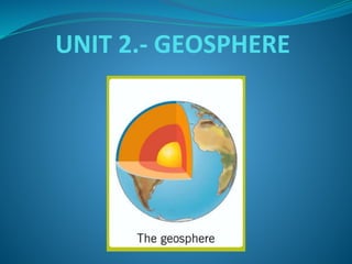
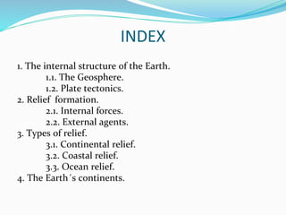
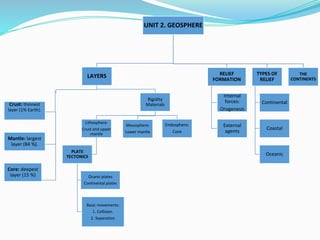
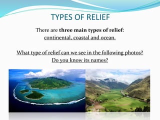
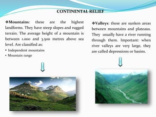
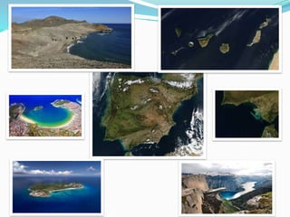
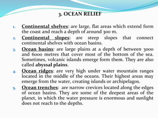
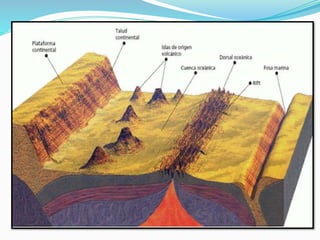
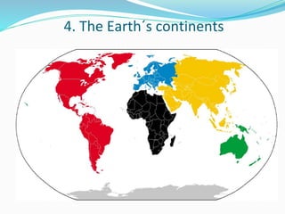
UNIT 2.- GEOSPHERE
INDEX
1. The internal structure of the Earth.
1.1. The Geosphere.
1.2. Plate tectonics.
2. Relief formation.
2.1. Internal forces.
2.2. External agents.
3. Types of relief.
3.1. Continental relief.
3.2. Coastal relief.
3.3. Ocean relief.
4. The Earth´s continents.
UNIT 2. GEOSPHERE
LAYERS
Crust: thinnest
layer (1% Earth).
Mantle: largest
layer (84 %).
Core: deepest
layer (15 %)
Rigidity
Materials
Lithosphere:
Crust and upper
mantle
PLATE
TECTONICS
Ocanic plates
Continental plates
Basic movements:
1. Collision.
2. Separation
Mesosphere:
Lower mantle
Endosphere:
Core
RELIEF
FORMATION
Internal
forces:
Orogenesis
External
agents
TYPES OF
RELIEF
Continental
Coastal
Oceanic
THE
CONTINENTS
TYPES OF RELIEF
There are three main types of relief:
continental, coastal and ocean.
What type of relief can we see in the following photos?
Do you know its names?
1. CONTINENTAL RELIEF
❖Plateaus (mesetas): these are flat or
gently undulating areas located at an
average altitude of about 650 m above sea
level. On its, erosion leaves the hardest
rocks exposed. Important: high plateaus
(altiplanos) are located between major
mountain ranges at altitudes above to 3.000
m.
❖Plains (llanuras): these are flat areas
located at altitudes below 150 m. The
materials they are made up of are the
result of transportation and deposition
processes.
CONTINENTAL RELIEF
❖Valleys: these are sunken areas
between mountains and plateaus.
They usually have a river running
through them. Important: when
river valleys are very large, they
are called depressions or basins.
❖Mountains: these are the highest
landforms. They have steep slopes and rugged
terrain. The average height of a mountain is
between 1.000 and 3.500 metres above sea
level. Are classified as:
▪ Independent mountains
▪ Mountain range
2. COASTAL RELIEF
1. Peninsulas: area of land connected to the mainland and
surrounded by water on three sides, except of one called
isthmus.
2. Capes: pieces of land which extend into the sea. If the cape
is small, it is called a point.
3. Gulfs: areas of the sea surrounded by land except on one
side. If a golf is small, it is called bay.
4. Inlets: areas where the sea floods into a deep and narrow
valley. When inlets are formed in glacial valleys, they are
called fiords. For instance, in Galician inlets are very
typical: they are called rías.
5. Islands: are pieces of land surrounded by water on all sides.
A group of islands is an archipelago.
3. OCEAN RELIEF
1. Continental shelves: are large, flat areas which extend form
the coast and reach a depth of around 300 m.
2. Continental slopes: are steep slopes that connect
continental shelves with ocean basins.
3. Ocean basins: are large plains at a depth of between 3000
and 6000 metres that cover most of the bottom of the sea.
Sometimes, volcanic islands emerge form them. They are also
called abyssal plains.
4. Ocean ridges: are very high under water mountain ranges
located in the middle of the oceans. Their highest areas may
emerge from the water, creating islands or archipelagos.
5. Ocean trenches: are narrow crevices located along the edges
of ocean basins. They are some of the deepest areas of the
planet, in which the water pressure is enormous and sunlight
does not reach to the depths.
4. The Earth´s continents
From largest to smallest
1. Asia
2. America
3. Africa
4. Antarctica
5. Europe
6. Oceania
Look at these interesting links:
⚫ http://www.pequetiempo.com/pequetiempos/encontrar-
por/aprender-sobre/%C2%BFcu%C3%A1ntos-continentes-hay-en-la-
tierra-1
⚫ https://www.saberespractico.com/estudios/cultura-
general/%C2%BFcuantos-continentes-hay-y-cuales-son/

Geosphere

  • 1.
  • 2.
    INDEX 1. The internalstructure of the Earth. 1.1. The Geosphere. 1.2. Plate tectonics. 2. Relief formation. 2.1. Internal forces. 2.2. External agents. 3. Types of relief. 3.1. Continental relief. 3.2. Coastal relief. 3.3. Ocean relief. 4. The Earth´s continents.
  • 3.
    UNIT 2. GEOSPHERE LAYERS Crust:thinnest layer (1% Earth). Mantle: largest layer (84 %). Core: deepest layer (15 %) Rigidity Materials Lithosphere: Crust and upper mantle PLATE TECTONICS Ocanic plates Continental plates Basic movements: 1. Collision. 2. Separation Mesosphere: Lower mantle Endosphere: Core RELIEF FORMATION Internal forces: Orogenesis External agents TYPES OF RELIEF Continental Coastal Oceanic THE CONTINENTS
  • 4.
    TYPES OF RELIEF Thereare three main types of relief: continental, coastal and ocean. What type of relief can we see in the following photos? Do you know its names?
  • 6.
    1. CONTINENTAL RELIEF ❖Plateaus(mesetas): these are flat or gently undulating areas located at an average altitude of about 650 m above sea level. On its, erosion leaves the hardest rocks exposed. Important: high plateaus (altiplanos) are located between major mountain ranges at altitudes above to 3.000 m. ❖Plains (llanuras): these are flat areas located at altitudes below 150 m. The materials they are made up of are the result of transportation and deposition processes.
  • 7.
    CONTINENTAL RELIEF ❖Valleys: theseare sunken areas between mountains and plateaus. They usually have a river running through them. Important: when river valleys are very large, they are called depressions or basins. ❖Mountains: these are the highest landforms. They have steep slopes and rugged terrain. The average height of a mountain is between 1.000 and 3.500 metres above sea level. Are classified as: ▪ Independent mountains ▪ Mountain range
  • 8.
    2. COASTAL RELIEF 1.Peninsulas: area of land connected to the mainland and surrounded by water on three sides, except of one called isthmus. 2. Capes: pieces of land which extend into the sea. If the cape is small, it is called a point. 3. Gulfs: areas of the sea surrounded by land except on one side. If a golf is small, it is called bay. 4. Inlets: areas where the sea floods into a deep and narrow valley. When inlets are formed in glacial valleys, they are called fiords. For instance, in Galician inlets are very typical: they are called rías. 5. Islands: are pieces of land surrounded by water on all sides. A group of islands is an archipelago.
  • 10.
    3. OCEAN RELIEF 1.Continental shelves: are large, flat areas which extend form the coast and reach a depth of around 300 m. 2. Continental slopes: are steep slopes that connect continental shelves with ocean basins. 3. Ocean basins: are large plains at a depth of between 3000 and 6000 metres that cover most of the bottom of the sea. Sometimes, volcanic islands emerge form them. They are also called abyssal plains. 4. Ocean ridges: are very high under water mountain ranges located in the middle of the oceans. Their highest areas may emerge from the water, creating islands or archipelagos. 5. Ocean trenches: are narrow crevices located along the edges of ocean basins. They are some of the deepest areas of the planet, in which the water pressure is enormous and sunlight does not reach to the depths.
  • 12.
    4. The Earth´scontinents
  • 13.
    From largest tosmallest 1. Asia 2. America 3. Africa 4. Antarctica 5. Europe 6. Oceania Look at these interesting links: ⚫ http://www.pequetiempo.com/pequetiempos/encontrar- por/aprender-sobre/%C2%BFcu%C3%A1ntos-continentes-hay-en-la- tierra-1 ⚫ https://www.saberespractico.com/estudios/cultura- general/%C2%BFcuantos-continentes-hay-y-cuales-son/