GEOGRAPHY IGCSE: WEATHER MEASUREMENTS. It contains: difference between weather and climate, measuring the weather, what do we measure, temperature, precipitation, wind direction, Beaufort scale, cloud cover, air pressure, glossary.
GEOGRAPHY IGCSE: WEATHER MEASUREMENTS. It contains: difference between weather and climate, measuring the weather, what do we measure, temperature, precipitation, wind direction, Beaufort scale, cloud cover, air pressure, glossary.
Meteorology includes atmospheric chemistry and atmospheric physics with a major focus on weather forecasting. In the 20th century science of the atmosphere proceeded to the study of the composition of air and to the consideration of how concentrations of gases existing as traces in the atmosphere had modified over time and of chemical processes that create and destroy compounds in the air. We'll take the basics in this presentation.
In this lesson, you will learn about the climate in advance. This is a very interesting lesson that you will have memories about in all school levels that you were in. You will learn a new thing in this lesson that you didn`t learn it before. In this lesson, you will learn types, influences, zones, and factors of climate and etc. This presentation has so many slides because I want to show you many things that I like about climate.
This document looks at the factors that affect weather and climate. The weather systems that also affect the Caribbean is also examined. These include ITCZ, Hurricanes, Cold Fronts, Easterly waves, Anticyclones
Unit 8 - Information and Communication Technology (Paper I).pdfThiyagu K
This slides describes the basic concepts of ICT, basics of Email, Emerging Technology and Digital Initiatives in Education. This presentations aligns with the UGC Paper I syllabus.
How to Split Bills in the Odoo 17 POS ModuleCeline George
Bills have a main role in point of sale procedure. It will help to track sales, handling payments and giving receipts to customers. Bill splitting also has an important role in POS. For example, If some friends come together for dinner and if they want to divide the bill then it is possible by POS bill splitting. This slide will show how to split bills in odoo 17 POS.
Read| The latest issue of The Challenger is here! We are thrilled to announce that our school paper has qualified for the NATIONAL SCHOOLS PRESS CONFERENCE (NSPC) 2024. Thank you for your unwavering support and trust. Dive into the stories that made us stand out!
Model Attribute Check Company Auto PropertyCeline George
In Odoo, the multi-company feature allows you to manage multiple companies within a single Odoo database instance. Each company can have its own configurations while still sharing common resources such as products, customers, and suppliers.
How to Create Map Views in the Odoo 17 ERPCeline George
The map views are useful for providing a geographical representation of data. They allow users to visualize and analyze the data in a more intuitive manner.
The Roman Empire A Historical Colossus.pdfkaushalkr1407
The Roman Empire, a vast and enduring power, stands as one of history's most remarkable civilizations, leaving an indelible imprint on the world. It emerged from the Roman Republic, transitioning into an imperial powerhouse under the leadership of Augustus Caesar in 27 BCE. This transformation marked the beginning of an era defined by unprecedented territorial expansion, architectural marvels, and profound cultural influence.
The empire's roots lie in the city of Rome, founded, according to legend, by Romulus in 753 BCE. Over centuries, Rome evolved from a small settlement to a formidable republic, characterized by a complex political system with elected officials and checks on power. However, internal strife, class conflicts, and military ambitions paved the way for the end of the Republic. Julius Caesar’s dictatorship and subsequent assassination in 44 BCE created a power vacuum, leading to a civil war. Octavian, later Augustus, emerged victorious, heralding the Roman Empire’s birth.
Under Augustus, the empire experienced the Pax Romana, a 200-year period of relative peace and stability. Augustus reformed the military, established efficient administrative systems, and initiated grand construction projects. The empire's borders expanded, encompassing territories from Britain to Egypt and from Spain to the Euphrates. Roman legions, renowned for their discipline and engineering prowess, secured and maintained these vast territories, building roads, fortifications, and cities that facilitated control and integration.
The Roman Empire’s society was hierarchical, with a rigid class system. At the top were the patricians, wealthy elites who held significant political power. Below them were the plebeians, free citizens with limited political influence, and the vast numbers of slaves who formed the backbone of the economy. The family unit was central, governed by the paterfamilias, the male head who held absolute authority.
Culturally, the Romans were eclectic, absorbing and adapting elements from the civilizations they encountered, particularly the Greeks. Roman art, literature, and philosophy reflected this synthesis, creating a rich cultural tapestry. Latin, the Roman language, became the lingua franca of the Western world, influencing numerous modern languages.
Roman architecture and engineering achievements were monumental. They perfected the arch, vault, and dome, constructing enduring structures like the Colosseum, Pantheon, and aqueducts. These engineering marvels not only showcased Roman ingenuity but also served practical purposes, from public entertainment to water supply.
The Indian economy is classified into different sectors to simplify the analysis and understanding of economic activities. For Class 10, it's essential to grasp the sectors of the Indian economy, understand their characteristics, and recognize their importance. This guide will provide detailed notes on the Sectors of the Indian Economy Class 10, using specific long-tail keywords to enhance comprehension.
For more information, visit-www.vavaclasses.com
2024.06.01 Introducing a competency framework for languag learning materials ...Sandy Millin
http://sandymillin.wordpress.com/iateflwebinar2024
Published classroom materials form the basis of syllabuses, drive teacher professional development, and have a potentially huge influence on learners, teachers and education systems. All teachers also create their own materials, whether a few sentences on a blackboard, a highly-structured fully-realised online course, or anything in between. Despite this, the knowledge and skills needed to create effective language learning materials are rarely part of teacher training, and are mostly learnt by trial and error.
Knowledge and skills frameworks, generally called competency frameworks, for ELT teachers, trainers and managers have existed for a few years now. However, until I created one for my MA dissertation, there wasn’t one drawing together what we need to know and do to be able to effectively produce language learning materials.
This webinar will introduce you to my framework, highlighting the key competencies I identified from my research. It will also show how anybody involved in language teaching (any language, not just English!), teacher training, managing schools or developing language learning materials can benefit from using the framework.
The French Revolution, which began in 1789, was a period of radical social and political upheaval in France. It marked the decline of absolute monarchies, the rise of secular and democratic republics, and the eventual rise of Napoleon Bonaparte. This revolutionary period is crucial in understanding the transition from feudalism to modernity in Europe.
For more information, visit-www.vavaclasses.com
Operation “Blue Star” is the only event in the history of Independent India where the state went into war with its own people. Even after about 40 years it is not clear if it was culmination of states anger over people of the region, a political game of power or start of dictatorial chapter in the democratic setup.
The people of Punjab felt alienated from main stream due to denial of their just demands during a long democratic struggle since independence. As it happen all over the word, it led to militant struggle with great loss of lives of military, police and civilian personnel. Killing of Indira Gandhi and massacre of innocent Sikhs in Delhi and other India cities was also associated with this movement.
Thesis Statement for students diagnonsed withADHD.ppt
Unit 3 weather and climate wiki
1. Geography and History 1º ESO Unit 3 Weather and climate
1
Unit 3 Weather and climate
Contents
I- Elements and factors of the weather
II- Climates of the world
In this unit we are going to study the atmosphere, another layer of the Earth that affects
directly to Geography. As you probably know, this layer reaches an altitude of 10000
km, but we are going to focus on the troposphere, which is in contact whit the Earth and
only reaches approximately 12 km. It is in this layer where the meteorological
phenomena happen.
I- Elements and factors of the weather
We must understand that the Earth works as a big system where every part is
interconnected, so although we are going to study the different elements and factors
separately all of them affect jointly to the weather and climate of our planet.
First of all, we must know the difference between weather and climate. The weather is
defined as the state of the atmosphere at a particular time and place, and it is studied by
meteorologists. The climate is the average state of the weather in a place or region over
a long time (at least 30 years), and it is studied by a science called climatology.
The elements and factors that make up the climate are:
a) Temperature
It is measured by thermometers (degrees Celsius or Fahrenheit) and indicates the heat of
the environment. It depends on three factors:
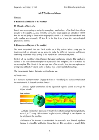
- Latitude: higher temperature in the equatorial regions, colder as you go to
higher latitude.
- Altitude: temperature decreases with elevation (that is called thermal gradient),
about 0, 6 ºC every 100 meters of height increase, although it also depends on
the winds and the sunshine.
- Influence of the sea and ocean currents: the sea works as a thermal regulator
because it gets colder and hotter slower than air. This way, there is usually little
2. Geography and History 1º ESO Unit 3 Weather and climate
2
temperature variation. However, the proximity of a cold or warm current can
modify the humidity and temperature of a region.
b) Humidity and precipitation
It refers to the amount of water vapour in the air. We have to know that hot air can
support more vapour before raining, while cold air admits less. It is important because,
as we know, temperature decreases as long as we get higher, and it is the cause of rain.
The humidity is measured as relative or as absolute, but only the first one tells us if the
rain is coming (take a look at your mobile and look for this information in the weather
forecast app). If it is close to 100%, take your umbrella! It is measure by hygrometers,
while precipitation is measured by pluviometers shown in litres per square (L/m2
) or
millimeters (mm).
The main types of precipitation are three. The first one is the convectional rain (storms)
produced because the Sun heats the air in the Earth´s surface and it rises quickly,
creating clouds (cumulus nimbus) where condensation makes rain happen (sometimes
pouring hail).
The second one is relief rainfall
produced when warm air rises trying to
pass a mountain range, so it gets colder.
Cold air admits less humidity than the
hot one, so condensation makes drops
that form the rain. This kind of rain
makes one slope of the mountains to be
wetter than the other one.
The third type is the frontal rainfall
produced when warm and cold masses
of air meet and generate cold or warm
fronts with unstable weather.
c) Atmospheric pressure and wind
It is defined as the weight of the air in a
particular area, which is measured by a
barometer in millibars (mbar) or
hectopascals (hPa). The pressure depends
on the altitude (lower at higher places) and
temperature (hot air weights less and rises,
3. Geography and History 1º ESO Unit 3 Weather and climate
3
just like aerostatic balloons). It is considered that the
normal point of pressure is 1013 mbar. If a place has
higher pressure there is an anticyclone, with cold air
descending and stable weather. If the pressure is lower
than 1013 mbar there is a cyclone, with hot air rising
and unstable weather. The difference of pressure
between two areas generates wind, faster if it is a huge
difference, because pressure tends to equilibrate itself. If you look at a weather forecast
map you can see isobars, which are lines that join points with equal pressure. If isobars
are close it means that wind is coming!
Moreover, the whole planet has prevailing winds due to the Earth´s rotation (such as the
equatorial trade winds), the Sun heat in difference seasons (monsoons in Asia) or local
winds (Cierzo, Galerna, Mistral, etc.). And don´t forget the best known of all the
weather hazards, tornadoes and hurricanes, which are originated in hot and wet areas
with very low pressure. The wind speed is measured with anemometers (hurricane
Katrina reached over 240 km/h!).
To sum up, we can say that meteorologists study all
these elements and factors of the weather to make
their forecast, an issue of extreme importance not
only for economic reasons, but also because a
correct forecast of a hurricane or flood can help
saving lives in many places of the world.
Fortunately, nowadays it is easier because satellites
can take photographs from the space and computers
can generate thousands of forecasts just in some
minutes. Did you know that there are TV channels
that only broadcast weather forecast twenty four hours a day? We recommend you to
watch the weather forecast on TV every day, it is a
free lesson of Geography!
II- Climates of the world
We already know that Sun heats the Earth and it is
the origin of weather phenomena. If we would only
pay attention to this factor, we could separate the
Earth´s climates in different stripes according to the
amount of sunshine that reaches each latitude of our
planet. And, in effect, this is the first factor to describe the climates on Earth, but we
also know that altitude and distance to sea alters the climate, so it won´t be so easy to
study!
First of all, we have the hot climates in regions situated between the two tropic lines,
Capricorn and Cancer, both at 23º of latitude (South and North respectively). We will
study the equatorial, tropical and desert climates. Secondly, we will see the temperate
4. Geography and History 1º ESO Unit 3 Weather and climate
4
climates of the regions between the tropic lines and the Arctic/ Antarctic Circle (both at
66º of latitude). In these areas we have the mediterranean, continental, oceanic and
humid subtropical climates (Chinese climate). Lastly, we have the cold climates, with
Polar Regions in the higher latitudes of the planet, and alpine climate in the main
mountain ranges all over the world.
You can take a look at the location of each climate in this map:
In order to study every climate, we are going to focus on temperature and precipitations,
and both elements can be represented in a graphic named climograph. This way, just
having a glance at a climograph we can identify a climate (as you will do in the
activities). We are going to study the simplest classification, although you have to know
that there are others quite a lot of precise.
a) Hot climates
- Equatorial climate
It has high temperatures and abundant rain throughout the year, with an average over 22
ºC (low thermal amplitude) and more than 2000 mm. There are no different seasons at
all.
- Tropical climates
Although it is further from the Equator, temperatures continue very high (over 22º every
month) but the thermal amplitude is bigger (no more than 5ºC). Precipitation is
abundant but there is a dry season, more pronounced as you go to higher latitude.
- Desert/ dry climate
Deserts regions are spread in latitudes of 30º North and South because cold wind
descend to the surface. A desert climate has significant differences between night and
5. Geography and History 1º ESO Unit 3 Weather and climate
5
day temperatures, but its main feature is the scarcity of rain, lower than 250 mm a year.
Moreover, we can also find coastal deserts in the West side of some continents and
frozen deserts, with very low temperatures and precipitation in form of snow.
b) Temperate / mild climates
- Mediterranean climate
This one has hot summers and mild winters, with an average temperature between 15
and 20º C. Autumn and spring are the wet seasons, although rain is scarce throughout
the year (no more of 700 mm), and summer rain is produced by storms. It is the climate
of the most of our country, although we can talk about the Mediterranean- continental
climate, with cold winters and very hot summers due to the isolation respect the seas
influence.
- Continental climate
It is the climate with the highest thermal amplitude due to the huge distance from the
oceans, with hot summers and very cold winters and low precipitation in summer time.
- Oceanic climate
Its thermal amplitude is low, with cool winters and mild summers, but the main feature
is the big amount of rain (over 800 mm), distributed througout the year. It is the typical
climate of the North side of our country.
- Humid subtropical climate/ Chinese climate
It is similar to the Mediterranean climate, but rain happen in the summer and are more
abundant (over 1000 mm) because it is located in the East side of the continents and
these regions are fed with the moisture of the oceans.
c) Cold climates
- Polar climate
It has very low temperature due to the scarce sunshine that it receives, especially during
the long winters. Precipitations are very low (we can talk about cold deserts) and always
in the form of snow.
- Alpine climate
This climate depends on altitude, although it is more likely to be located far from the
Equator regions. It is the typical climate of high mountains, with cold winters and cool
summers, sometimes preserving the snow in the peaks throughout the year.
And now we know the world´s climates, we are prepared to study its natural
environments, where we will put all together the knowledge we have learnt in the last
units. But it will be in the next unit, the last one dedicated to Geography!