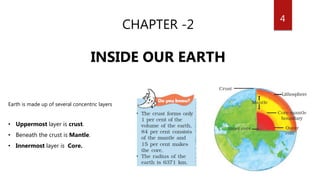
GEOGRAPHY
7th Class
1
2
CHAPTER -1
ENVIRONMENT
• ENVIRONMENT : Place, people, things and nature that surround
any living organism.
• It is a combination of natural and human made phenomena.
3
NATURAL
ENVIRONMENT
• Land, water, air, plants
and animals comprise
the natural
environment.
• Lithosphere,
Hydrosphere,
Atmosphere, Biosphere
HUMAN ENVIRONMENT
• Human beings interact
with the environment
and modify it according
to their need.
• Early humans adapted
themselves to the
natural surroundings
4
CHAPTER -2
INSIDE OUR EARTH
Earth is made up of several concentric layers
• Uppermost layer is crust.
• Beneath the crust is Mantle.
• Innermost layer is Core.
5CRUST
• Thinnest of all the layers.
• It is about 35 km on the continental masses & 5 km on the ocean floors.
• continental mass mainly consists of silica & alumina. It is thus called sial (si-silica & al-alumina).
• Oceanic crust mainly consists of silica & magnesium; it is thus called sima (si-silica & ma-magnesium)
MANTLE
• Beneath the crust
• Extends up to a depth of 2900 km below the crust.
CORE
• Radius of about 3500 km.
• Mainly made up of nickel and iron.
• Called nife (ni – nickel and fe – ferrous i.e. iron).
• The central core has very high temperature and pressure.
6
ROCKS AND MINERALS
• Any natural mass of mineral matter that makes up the earth’s crust is called a rock.
• There are 3 major types of rocks:
• Igneous rocks
• Sedimentary rocks
• Metamorphic rocks.
IGNEOUS ROCKS:
• Molten magma cools & becomes solid Igneous rocks.
• Called primary rocks
• There are 2 types of igneous rocks: intrusive rocks and extrusive rocks.
1) EXTRUSIVE ROCKS
• Molten lava comes on the earth’s surface, it rapidly cools down and becomes solid.
• Very fine grained structure.
• Example :Basalt, The Deccan plateau is made up of basalt rocks.
2) INTRUSIVE ROCKS
• Molten magma cools down deep inside the earth’s crust.
• Since they cool down slowly they form large grains.
• Example: Granite
7SEDIMENTARY ROCKS
• Rocks roll down, crack, and hit each other & are broken down into small fragments called sediments.
• They are transported and deposited by wind, water, etc. & compressed and hardened to form layers of
sedimentary rocks.
• Example : Sandstone is made from grains of sand.
• May also contain fossils.
METAMORPHIC ROCKS
• Igneous and sedimentary rocks can change into metamorphic
rocks under great heat and pressure
• Example: clay changes into slate and limestone into marble
8
ROCK CYCLE
Magma cools down &
forms Igneous rocks
Roll down, crack, and hit each
other and are broken
compressed and hardened
under great
heat and
pressure
under Extreme heat
and pressure
Note: DiagrammaticalRepresentation of theoryof
above slides
9
MINERALS
• Rocks are made up of different minerals.
• Naturally occurring substances
• Have certain physical properties and definite chemical composition.
• Minerals are very important to humankind.
• Some are used as fuels.
• Example: coal, natural gas and petroleum.
10
CHAPTER -3
OUR CHANGING EARTH
• Lithospheric plates move around very slowly – just a few millimeters
each year.
• This is because of the movement of the molten magma inside the
earth.
• The movement of these plates causes changes on the surface of the
earth
11
Note:Veryimportantslide****
12The earth movements are divided on the basis of the forces which cause them.
• Forces which act in the interior of the earth are called as Endogenic forces
• Forces that work on the surface of the earth are called as Exogenic forces
EARTHQUAKES
• Lithospheric plates move, the surface of the earth vibrates.
• They can travel all round the earth. These vibrations are called
earthquakes.
• Focus : Place in the crust where the movement starts .
• Epicentre :Place on the surface above the focus.
• Vibrations travel outwards from the epicentre as waves.
• Greatest damage is usually closest to the epicentre
• Strength of the earthquake decreases away from the centre.
• Example: A massive earthquake measuring 6.9 on Richter scale hit
Bhuj Town on 26th January 2001.
13
The landscape is being continuously worn away by two processes.
• Weathering : Breaking up of the rocks on the earth’s surface.
• Erosion : Wearing away of the landscape by different agents like water, wind and ice.
WORK OF A RIVER:
• The running water in the river erodes the landscape.
• Waterfall : River tumbles at steep angle over very hard rocks or down a steep valley side
• Meanders : River enters the plain, twists and turns forming largebends.
• Ox-bow lake : Due to continuous erosion and deposition the meander loop
cuts off from the river and forms a cut-off lake.
• Floodplain : Flat fertile land.
• Levees : Raised banks
• As the river approaches the sea, the speed of water decreases and river
begins to break up into a number of streams called distributaries.
• Each distributary forms its own mouth.
• Delta : collection of sediments from all the mouths
14
WORK OF SEA WAVES:
• The erosion and deposition gives rise to coastal landforms.
• Sea caves : Waves continuously strike rocks (Cracks develop), Hollow caves are formed on the rocks.
• Sea arches : Cavities become bigger ,only the roof of the caves remain.
• Stacks : Erosion breaks the roof and only walls are left.
• Sea cliff : Steep rocky coast rising almost vertically above sea water.
• Beaches : Sea waves deposit sediments along the shores
WORK OF ICE
• Glaciers carve out deep hollows.
• Glacial moraines : Material carried by glacier such as rocks big and small, sand and silt gets deposited.
WORK OF WIND
• In deserts you can see rocks in the shape of a mushroom, commonly called mushroom rocks.
• Winds erode the lower section of the rock more than the upper part.
• Loess : Very fine and light grains of sand is carried by wind over very long distances. Such sand is deposited in
large areas.
• Large deposits of loess is in China.
15
16
CHAPTER -4
AIR
• Plants need nitrogen for their survival.
• They can not take nitrogen directly from the
air.
• Bacteria, that live in the soil and roots of some
plants, take nitrogen from the air and change
its form so that plants can use it.
17
TROPORSPHERE:
• Most important layer of the atmosphere.
• Its average height is 13 km.
• The air we breathe exists here.
• Weather phenomena like rainfall, fog and hailstorm occur in this layer.
STRATOSPHERE
• It extends up to a height of 50 km.
• Almost free from clouds and associated weather phenomenon
• Ideal for flying aeroplanes.
• Contains a layer of ozone gas.
MESOSPHERE
• It extends up to the height of 80 km.
• Meteorites burn up in this layer on entering from the space.
THERMOSPHERE
• Temperature rises very rapidly with increasing height.
• Ionosphere is a part of this
• It extends between 80-400 km.
• Helps in radio transmission.
• Radio waves transmitted from earth are reflected back by this layer.
EXOSPHERE:
• Very thin air.
• Light gases like helium and hydrogen float into the space from here.
STRUCTURE OF THE
ATMOSPHERE
18
TEMPERATURE
• An important factor that influences the distribution of temperature is INSOLATION.
• Insolation is the incoming solar energy intercepted by the earth.
• The amount of insolation decreases from the equator towards the poles.
• The standard unit of measuring temperature is degree Celsius.
• It was invented by Anders Celsius.
AIR PRESSURE
• Highest at sea level and decreases with height.
• Horizontally influenced by temperature of air at a given place.
• High Temperature Air gets heated & rises low-pressure area
• Low pressure is associated with cloudy skies and wet weather.
• Lower temperature Air is cold &heavy High pressure area.
• High pressure is associated with clear and sunny skies.
• Air always moves from high pressure areas to low pressure areas.
19WIND : Movement of air from high pressure area to low pressure areas
Winds can be broadly divided into three types.
1. Permanent winds
• The trade winds, westerlies and easterlies
• Blow constantly throughout the year in a particular direction.
2. Seasonal winds
• These winds change their direction in different seasons.
• Example :
• Monsoons in India.
3. Local winds
• Blow only during a particular period of the day or year in a small area.
• Example :
• Land & sea breeze.
• Hot and dry local wind of northern planes of India. It is called loo.
20
MOISTURE
• Moisture in the air at any time, is known as humidity.
• When the air is full of water vapour we call it a humid day.
• As the air gets warmer, its capacity to hold the water vapour increases
and so it becomes more and more humid.
• Precipitation that comes down to the earth in liquid form is called rain.
On the basis of mechanism, there are 3 types of rainfall:
Convectional rainfall
Orographic rainfall
Cyclonic rainfall
21
CHAPTER -5
WATER
• Earth is like a terrarium.
• Terrarium: It is an artificial enclosure for keeping
small house plants.
22
WATER CYCLE
DISTRIBUTION OF WATER
BODIES
Note:Veryimportantslide****
23OCEAN CIRCULATION
Movements that occur in oceans can be categorized as: waves, tides and currents.
WAVES
• Water on the surface of the ocean rises and falls alternately
• During a storm, the winds blowing at very high speed form huge waves.
• An earthquake, a volcanic eruption or underwater landslides can shift large amounts of ocean water.
• As a result a huge tidal wave called tsunami, that may be as high as 15m, is formed.
• Largest tsunami was 150m high. These waves travel at a speed of more than 700 kmph.
• Indira point in the Andaman and Nicobar islands got submerged after the tsunami on 26th Dec,2004.
OCEAN CURRENTS
• Streams of water flowing constantly on the ocean surface in definite
directions.
• May be warm or cold
• Influence the temperature conditions of the area
24
• Warm ocean currents originate near the equator & move towards the poles.
• Warm currents bring about warm temperature over land surface.
• Example : Gulf Stream
• Cold currents carry water from polar (higher latitudes) to tropical (lower latitudes).
• Example : Labrador Ocean current
NOTE:
• Areas where the warm and cold currents meet provide the best fishing grounds of the world.
• These are foggy , making it difficult for navigation
• Example : Seas around Japan and the eastern coast of North America
TIDES
• Rhythmic rise and fall of ocean water twice in a day.
• High tide : Water cover much of the shore by rising to its highest level.
• Low tide : Water falls to its lowest level and recedes from the shore.
• Strong gravitational pull exerted by SUN & MOON on the earth’s surface causes tides.
25
Spring tides
• During the full moon and new moon days.
• Sun, Moon & Earth are in same line and tides are highest.
• Help in navigation & fishing(due to high tides) .
• Helps the ships to arrive at the harbour more easily
Neap tides
• Moon is in its first and last quarter
• Ocean waters get drawn in diagonally opposite directions by the
gravitational pull of sun and earth resulting in low tides.
• Help in electricity generation.
Water of the earth closer to the moon gets pulled under the influence of the moon’s
gravitational force and causes high tide.
26
CHAPTER -6
NATURAL VEGETAION &
WILDLIFE
• Growth of vegetation depends on temperature and moisture.
• It also depends on factors like slope and thickness of soil.
27Natural vegetation is generally classified in to 3 broad categories as follows:
Forests:
• Grow where temperature and rainfall are plentiful .
Grasslands:
• Grow in the region of moderate rain.
Shrubs:
• Thorny shrubs and scrubs grow in the dry region
FORESTS
TROPICAL RAIN FOREST
• Occur in the areas which receive heavy rainfall.
• Highly dense that sunlight doesn’t reach the ground.
• Many species of trees are found in these forests, which shed their leaves at different times of the year.
• Therefore, they always appear green and are called evergreen forest .
• Important trees found in these forests are mahogany, ebony and rosewood.
• Occur in the regions near the equator and close to the tropics.
28
TROPICAL DECIDUOUS FORESTS
• Also called monsoon forests.
• They are less dense.
• They shed their leaves at dry Season to conserve water.
• Important trees of these forests are sal, teak, peepal, neem and shisham.
• Tigers, lions, elephants, langoors and monkeys are commonly found animals.
• They are found in parts of India, northern Australia and in central America
TEMPERATE EVERGREEN FORESTS
• Located in the mid latitudinal coastal region & eastern margin of the continents.
• In south east USA, South China and in South East Brazil.
• They comprise both hard and soft wood trees like oak,pine, eucalyptus, etc.
TEMPERATE DECIDOUS FORESTS
• Higher latitudes,
• Found in north eastern part of USA, China, New Zealand, Chile and also in coastal regions of Western Europe.
• They shed their leaves in the dry season.
• The common trees are oak, ash, beech, etc.
• Animals like Deer, foxes, wolves & Birds like pheasants, monals are commonly found.
29
MEDITERRANEAN VEGETATION
• West and south west margins of the continents
• Found in areas around the Mediterranean sea in Europe, Africa and Asia
• Marked for hot dry summers and mild rainy winters.
• Citrus fruits such as oranges, figs, olives and grapes are commonly
• There isn’t much wildlife here.
CONIFEROUS FORESTS
• Higher latitudes (50° – 70°) of Northern hemisphere
• Also called as Taiga.
• Seen in the higher altitudes.
• They are tall, softwood evergreen trees.
• The woods of these trees are very useful for making pulp.
• Chir, pine, cedar are the important variety of trees in these forests.
• Silver fox, mink, polar bear are the common animals found here.
30
GRASSLANDS
TROPICAL GRASSLANDS
• Occur on either side of the equator and extend till the tropics
• Grows in the areas of moderate to low amount of rainfall.
• Grass can grow very tall, about 3 to 4 m height.
• Example : Savannah grasslands of Africa
• Elephants, zebras, giraffes, deer, leopards are commonly found
TEMPERATE GRASSLANDS
• Found in mid latitudinal zones and in interior part of the continents.
• Grass here is short and nutritious.
• Wild buffaloes, bisons, antilopes are commonly found.
THORNY BUSHES
• Found in dry desert like regions, generally western margins of continents.
• Vegetation cover is scarce here because of scanty rain and scorching heat.
TUNDRA VEGETATION
• Found in the polar areas of Europe, Asia and North America.
• Only mosses, lichens and very small shrubs are found here during the very short summer
• Seal,walruses, musk-oxen, Arctic owl, Polar bear and snow foxes are commonly found
31
CHAPTER -7
HUMAN ENVIRONMENT-
SETTLEMENT, TRANSPORT,
COMMUNICATION
• SETTLEMENTS are places where people build their homes.
• TEMPORARY SETTLEMENTS : Settlements for a short time
• People living in deep forests, hot & cold deserts and mountains
• They practice hunting, gathering and transhumance.
• PERMANENT SETTLEMENTS : Settlements for a long time
32
RURAL SETTLEMENTS
• Villages
• People engage in activities like agriculture, fishing, forestry, crafts work & trading etc.
• Rural settlements can be compact or scattered.
• A compact settlement is a closely built area of dwellings, wherever flat land is available
• A scattered settlement dwellings are spaced over an extensive area.
• Mostly found in hilly tracts, thick forests, and regions of extreme climate
URBAN SETTLEMENTS
• Towns and cities
• People engage in manufacturing,trading, and services.
TRANSPORT
India- Donkeys, mules, bullocks and camels
Andes Mountains of South America- llamas
Tibet- Yaks
In olden days
33
ROADWAYS
• Especially for short distances are roads.
• They can be metalled (pucca) and unmetalled (kutcha)
• Plains have a dense network of roads.
• Manali-Leh highway in Himlayan Mountains is one of highest roadways in world.
RAILWAYS
• Carry heavy goods and people over long distances quickly and cheaply.
• Invention of Steam engine and Industrial Revolution helped in speedy development of rail transport.
• Indian railway network is largest in Asia.
WATERWAYS
• cheapest for carrying heavy and bulky goods over long distances.
• Mainly of two types – inland waterways and sea routes.
Navigable rivers and lakes used for transporting merchandise and goods from one country to another.
Routes are connected with the ports.
AIRWAYS
• Fastest way of transport developed in the early twentieth century
34
35
Note:
Notveryimportant
36
CHAPTER -8
TROPICAL AND SUB TROPICAL
REGION
• Tropical region lies very close to the equator; between 10°N and 10°S.
• It is referred to as the equatorial region.
• The river Amazon flows through this region.
• It flows from mountains to west and reaches Atlantic Ocean to east.
• River basin drains portions of Brazil, parts of Peru, Bolivia, Ecuador,
Columbia and a small part of Venezuela.
37
RAINFORESTS
• Rains heavily in this region, thick forests grow
• Leaves and branches does not allow the sunlight to reach ground.
• Orchids, bromeliads grow as plant parasites.
• The rainforest is rich in fauna.
• Animals like monkeys, sloth and ant-eating tapirs are found here
• Various species of reptiles and snakes also thrive in these jungles. Crocodiles,
Anaconda and boa constrictor are some of the species.
• Besides, the basin is home to thousands of species of insects.
• Several species of fishes including flesh eating Piranha fish is also found in the
river.
• Birds such as toucans, humming birds, bird of paradise with their brilliantly
coloured plumage, oversized bills for eating make them different from birds we
commonly see in India.
• Birds also make loud sounds in the forests.
38
PEOPLE OF THE RAINFORESTS
• People grow most of their food in small areas after clearing some trees in the forest.
• They mainly grow tapioca, pineapple and sweet potato.
• They practice “slash and burn agriculture”.
• The staple food is manioc, also known as cassava that grows under the ground.
• They also eat queen ants and egg sacs.
• Cash crops like coffee, maize and cocoa are also grown.
• The rainforests provide a lot of wood for the houses.
• Some families live in thatched houses shaped like beehives.
• There are other large apartment-like houses called “Maloca” with steeply slanting roof.
• In the older days the heart of the forest, could be reached only by navigating the river.
• In 1970 the Trans Amazon highway made all parts of the rainforest accessible.
CLIMATE
• Hot and wet climate throughout the year.
• Both day and nights are almost equally hot and humid.
• It rains almost everyday.
• Day temperatures are high with very high humidity.
• Night temperature are low but the humidity remains high.
39
LIFE IN THE GANGA-BRAHMAPUTRA BASIN
• Basin lies in sub-tropical region that is situated between 10°N to 30°N latitudes.
• Tributaries of River Ganga (Ghaghra, Son, Chambal, Gandak, Kosi) & tributaries of
Brahmaputra drain it
• Area is dominated by monsoon climate (Rains from mid-June to mid-September).
• Summers are hot and winters cool.
• varied topography.
• Density of population of plains is very high & Mountains is low.
• Main crop - paddy
• Wheat, maize, sorghum, gram and millets are other crops that are grown.
• Cash crops - sugarcane and jute .
• Banana plantations are seen in some areas of the plain.
• West Bengal and Assam - TEA.
• Bihar and Assam - Silk.
• In mountains and hills they have step Farming.
40
• Plain tropical deciduous trees grow, along with teak, sal and peepal.
• Brahmaputra plain - Thick bamboo groves
• Delta area -Mangrove forests.
• Uttarakhand, Sikkim and Arunachal Pradesh -coniferous trees like pine, deodar and fir can be seen
because the climate is cool and the slopes are steep.
• Elephants, tigers, deer and monkeys are common.
• Brahmaputra plain -one-horned rhinoceros.
• Delta area - Bengal tiger, crocodiles and alligator are found.
• Varieties of the fish are the rohu, catla and hilsa.
• Fish and rice is the staple diet of the people living in the area.
NOTE : Thischapterhaslotof info,memorizeasmuchasyou can
41
CHAPTER -9
TEMPERATE GRASSLANDS
GRASSLANDS
Region where grasses form the dominant type of plant life.
• Types of plants that grow here depend on climate and soil
• Based on climate world’s grasslands are divided into 2 broad categories:
• Those that occur in the temperate region
• Those that occur in the tropical regions.
42
PRAIRIES
• Temperate grasslands of North America
• It is a region of flat, gently sloping or hilly land.
• For the most part, prairies are treeless
• But, near the low lying plains, woodlands can be found.
• Tall grass, up to 2m high.
• Bound by Rocky Mountains in West and Great Lakes in East.
• Prairies cover parts of United States of America and Canada.
• In USA, drained by tributaries of Mississippi
• In Canada, drained by tributaries of Saskatchewan Rivers.
CLIMATE
• Continental type with extreme temperatures.
• Summers are warm with temperatures of around 20°C,
• Winter -20°C has been recorded in Winnipeg, Canada.
• The annual rainfall is moderate and is ideal for the growth of grass.
• Due to the absence of the north-south barrier, a local wind “Chinook” blows here.
43
FLORA AND FAUNA
• Where water is available, trees such as willows, alders and poplars grow.
• Places that receive rainfall of over 50 cm, are suitable for farming as the soil is fertile.
• Major crop of this area is maize, other crops including potatoes, soybean, cotton and alfa-alfa is also grown.
• Areas where rainfall is very little or unreliable, grasses are short and sparse.
• These areas are suitable for cattle rearing.
• Large cattle farms called ranches are looked after by sturdy men called cowboys
• Bison or American buffalo is the most important animal of this region
• It nearly got extinct due to its indiscriminate hunting and is now a protected species.
• The other animals found in this region are rabbits, coyotes, gophers and Prairie dog.
PEOPLE
• People of this region are very hardworking.
• Scientific methods of cultivation and use of tractors, harvesters and combines
• Prairies are also known as the “Granaries of the world,”
• Dairy farming is another major industry.
• Dairy belt extends from Great Lakes to Atlantic Coast in east.
• Large mineral deposits particularly coal and iron.
• Good network of roads, railways and canals have made it the most industrialised region in the world.
44
VELDS
• Temperate grasslands of South Africa
• Rolling plateaus with varying heights ranging from 600 m to 1100 m.
• Bound by Drakensburg Mountains on east & Kalahari desert on west
• Northeastern part, “high velds” are located (height of more than 1600 m).
• The tributaries of rivers Orange and Limpopo drain the region.
• Lie in Southern hemisphere.
CLIMATE
• Mild climate due to the influence of the Indian Ocean.
• Winters are cold and dry & Summers are short and warm.
• Temperatures vary between 5°C and 10°C
• July is the coldest month.
• Johannesburg records about 20°C temperature in the summer
• Receive rainfall mainly in the summer months from November to February.
• Because of the warm ocean currents that wash the shores of the velds.
• If the rainfall is scanty in the winter months from June till August, drought may occur.
45
FLORA AND FAUNA
• Vegetation cover is sparse.
• Red grass grows in bush velds.
• In the high velds - acacia and maroola .
• Animals of the velds are primarily lions, leopards, cheetah and kudu
PEOPLE
• Cattle rearing and mining.
• Soils are not very fertile in the velds
• Main crops are maize, wheat, barley, oats and potato.
• Cash crops -tobacco, sugarcane and cotton
• Sheep rearing is the most important occupation of the people. Merino sheep is a popular species
• Dairy farming is the next important occupation.
• Have rich reserve of minerals.
• Iron and steel industry has developed where coal and iron are present.
• Gold and diamond mining are major occupations.
• Johannesburg is known for being the gold capital of the world*****.
• Kimberley is famous for its diamond mines******
• Mining of diamond and gold in South Africa led to the establishment of trade ties with Britain and gradually South
Africa became a British Colony.
• This mineral rich area has a well-developed network of transport.
46
CHAPTER -10
LIFE IN DESERTS
• Characterised by low rainfall, scanty vegetation and extreme
temperatures.
• Depending on the temperatures
• Hot deserts
• Cold deserts.
47
HOT DESERT – SAHARA
• World’s largest desert.
• Area =8.54 million sq. km.
• Touches eleven countries. These are Algeria, Chad, Egypt, Libya, Mali, Mauritania, Morocco, Niger, Sudan, Tunisia and
Western Sahara.
• Besides the vast stretches of sands, that Sahara desert is covered with, gravel plains and elevated plateaus with bare
rocky surface.
• These rocky surfaces may be more than 2500m high at some places
Climate
• scorching hot and parch dry.
• Has a short rainy season.
• Sky is cloudless and clear.
• Moisture evaporates faster than it accumulates.
• Temperatures during the day may soar as high as 50°C, heating up
the sand and the bare rocks, which in turn radiates heat making
everything around hot.
• The nights may be freezing cold with temperatures nearing zero
degrees.
48
Flora and Fauna
• Vegetation -cactus, date palms and acacia.
• There are oasis – green islands with date palms surrounding them.
• Camels, hyenas, jackals, foxes, scorpions, many varieties of snakes and lizards are prominent animals
People
• Bedouins and Tuaregs. These groups are nomadic tribes rearing livestock
• These animals provide them with milk, hides.
• They wear heavy robes as protection against dust storms and hot winds.
• Oasis in the Sahara and Nile Valley in Egypt supports settled population. Since water is
available, the people grow date palms.
• Crops such as rice, wheat, barley and beans are also grown.
• Egyptian cotton, famous worldwide is grown in Egypt*****
• The discovery of oil – a product in great demand throughout the world, in Algeria, Libya
and Egypt is constantly transforming the Sahara desert******
• Other minerals of importance that are found in the area include iron, phosphorus,
manganese and uranium.
• Tuaregs are seen acting as guides to foreign tourists.
49
COLD DESERT - LADAKH
• Ladakh is a cold desert lying in the Great Himalayas, on the eastern side of J &K.
• Karakoram Range in the north and the Zanskar mountains in the south enclose it.
• Several rivers flow, Indus being the most important. Rivers form deep valleys and gorges.
• Several glaciers are found in Ladakh,
• Example : Gangri glacier.
• Altitude in Ladakh varies from about 3000m in Kargil to more than 8,000m in Karakoram.
CLIMATE
• Due to its high altitude, the climate is extremely cold and dry.
• Air at this altitude is so thin that the heat of the sun can be felt intensely.
• Day temperatures in summer are just above zero degree
• Night temperatures well below –30°C.
• As it lies in the rain shadow of the Himalayas, there is little rainfall, as low as 10 cm every year.
50
Flora and Fauna
• Due to high aridity, the vegetation is sparse.
• Groves of willows and poplars are seen in the valleys.
• During the summers, fruit trees such as apples, apricots and walnuts bloom.
• Birds in Ladakh. Robins, redstarts, Tibetan snowcock, raven and hoopoe.
• Some are migratory birds
• Animals of Ladakh are wild goats, wild sheep, yak and special kinds of dogs.
• Animals are reared to provide for the milk, meat and hides.
• Yak’s milk is used to make cheese and butter.
• Hair of sheep and goat is used to make woollens.
People
• Ladakh and the inhabitants of Tibet and Central Asia resemble each other***
• The people here are either Muslims or Buddhists.
• In fact several Buddhists monasteries dot the Ladakhi landscape with their traditional ‘gompas’.
• Some famous monasteries are Hemis, Thiksey, Shey and Lamayuru.
• In summer season the people are busy cultivating barley, potatoes, peas, beans and turnip.
• Climate in winter months is so harsh that people keep themselves engaged in festivities and ceremonies.
• Leh, the capital of Ladakh .
• National Highway 1A connects Leh to Kashmir Valley through the Zoji la Pass******
51
NOTE:
LAST 3 CHAPTERS HAVE A HUGE DATA WHICH
NEEDS TO BE MEMORIZED
MEMORIZE AS MUCH AS YOU CAN

Geography 7

  • 1.
  • 2.
    2 CHAPTER -1 ENVIRONMENT • ENVIRONMENT: Place, people, things and nature that surround any living organism. • It is a combination of natural and human made phenomena.
  • 3.
    3 NATURAL ENVIRONMENT • Land, water,air, plants and animals comprise the natural environment. • Lithosphere, Hydrosphere, Atmosphere, Biosphere HUMAN ENVIRONMENT • Human beings interact with the environment and modify it according to their need. • Early humans adapted themselves to the natural surroundings
  • 4.
    4 CHAPTER -2 INSIDE OUREARTH Earth is made up of several concentric layers • Uppermost layer is crust. • Beneath the crust is Mantle. • Innermost layer is Core.
  • 5.
    5CRUST • Thinnest ofall the layers. • It is about 35 km on the continental masses & 5 km on the ocean floors. • continental mass mainly consists of silica & alumina. It is thus called sial (si-silica & al-alumina). • Oceanic crust mainly consists of silica & magnesium; it is thus called sima (si-silica & ma-magnesium) MANTLE • Beneath the crust • Extends up to a depth of 2900 km below the crust. CORE • Radius of about 3500 km. • Mainly made up of nickel and iron. • Called nife (ni – nickel and fe – ferrous i.e. iron). • The central core has very high temperature and pressure.
  • 6.
    6 ROCKS AND MINERALS •Any natural mass of mineral matter that makes up the earth’s crust is called a rock. • There are 3 major types of rocks: • Igneous rocks • Sedimentary rocks • Metamorphic rocks. IGNEOUS ROCKS: • Molten magma cools & becomes solid Igneous rocks. • Called primary rocks • There are 2 types of igneous rocks: intrusive rocks and extrusive rocks. 1) EXTRUSIVE ROCKS • Molten lava comes on the earth’s surface, it rapidly cools down and becomes solid. • Very fine grained structure. • Example :Basalt, The Deccan plateau is made up of basalt rocks. 2) INTRUSIVE ROCKS • Molten magma cools down deep inside the earth’s crust. • Since they cool down slowly they form large grains. • Example: Granite
  • 7.
    7SEDIMENTARY ROCKS • Rocksroll down, crack, and hit each other & are broken down into small fragments called sediments. • They are transported and deposited by wind, water, etc. & compressed and hardened to form layers of sedimentary rocks. • Example : Sandstone is made from grains of sand. • May also contain fossils. METAMORPHIC ROCKS • Igneous and sedimentary rocks can change into metamorphic rocks under great heat and pressure • Example: clay changes into slate and limestone into marble
  • 8.
    8 ROCK CYCLE Magma coolsdown & forms Igneous rocks Roll down, crack, and hit each other and are broken compressed and hardened under great heat and pressure under Extreme heat and pressure Note: DiagrammaticalRepresentation of theoryof above slides
  • 9.
    9 MINERALS • Rocks aremade up of different minerals. • Naturally occurring substances • Have certain physical properties and definite chemical composition. • Minerals are very important to humankind. • Some are used as fuels. • Example: coal, natural gas and petroleum.
  • 10.
    10 CHAPTER -3 OUR CHANGINGEARTH • Lithospheric plates move around very slowly – just a few millimeters each year. • This is because of the movement of the molten magma inside the earth. • The movement of these plates causes changes on the surface of the earth
  • 11.
  • 12.
    12The earth movementsare divided on the basis of the forces which cause them. • Forces which act in the interior of the earth are called as Endogenic forces • Forces that work on the surface of the earth are called as Exogenic forces EARTHQUAKES • Lithospheric plates move, the surface of the earth vibrates. • They can travel all round the earth. These vibrations are called earthquakes. • Focus : Place in the crust where the movement starts . • Epicentre :Place on the surface above the focus. • Vibrations travel outwards from the epicentre as waves. • Greatest damage is usually closest to the epicentre • Strength of the earthquake decreases away from the centre. • Example: A massive earthquake measuring 6.9 on Richter scale hit Bhuj Town on 26th January 2001.
  • 13.
    13 The landscape isbeing continuously worn away by two processes. • Weathering : Breaking up of the rocks on the earth’s surface. • Erosion : Wearing away of the landscape by different agents like water, wind and ice. WORK OF A RIVER: • The running water in the river erodes the landscape. • Waterfall : River tumbles at steep angle over very hard rocks or down a steep valley side • Meanders : River enters the plain, twists and turns forming largebends. • Ox-bow lake : Due to continuous erosion and deposition the meander loop cuts off from the river and forms a cut-off lake. • Floodplain : Flat fertile land. • Levees : Raised banks • As the river approaches the sea, the speed of water decreases and river begins to break up into a number of streams called distributaries. • Each distributary forms its own mouth. • Delta : collection of sediments from all the mouths
  • 14.
    14 WORK OF SEAWAVES: • The erosion and deposition gives rise to coastal landforms. • Sea caves : Waves continuously strike rocks (Cracks develop), Hollow caves are formed on the rocks. • Sea arches : Cavities become bigger ,only the roof of the caves remain. • Stacks : Erosion breaks the roof and only walls are left. • Sea cliff : Steep rocky coast rising almost vertically above sea water. • Beaches : Sea waves deposit sediments along the shores WORK OF ICE • Glaciers carve out deep hollows. • Glacial moraines : Material carried by glacier such as rocks big and small, sand and silt gets deposited. WORK OF WIND • In deserts you can see rocks in the shape of a mushroom, commonly called mushroom rocks. • Winds erode the lower section of the rock more than the upper part. • Loess : Very fine and light grains of sand is carried by wind over very long distances. Such sand is deposited in large areas. • Large deposits of loess is in China.
  • 15.
  • 16.
    16 CHAPTER -4 AIR • Plantsneed nitrogen for their survival. • They can not take nitrogen directly from the air. • Bacteria, that live in the soil and roots of some plants, take nitrogen from the air and change its form so that plants can use it.
  • 17.
    17 TROPORSPHERE: • Most importantlayer of the atmosphere. • Its average height is 13 km. • The air we breathe exists here. • Weather phenomena like rainfall, fog and hailstorm occur in this layer. STRATOSPHERE • It extends up to a height of 50 km. • Almost free from clouds and associated weather phenomenon • Ideal for flying aeroplanes. • Contains a layer of ozone gas. MESOSPHERE • It extends up to the height of 80 km. • Meteorites burn up in this layer on entering from the space. THERMOSPHERE • Temperature rises very rapidly with increasing height. • Ionosphere is a part of this • It extends between 80-400 km. • Helps in radio transmission. • Radio waves transmitted from earth are reflected back by this layer. EXOSPHERE: • Very thin air. • Light gases like helium and hydrogen float into the space from here. STRUCTURE OF THE ATMOSPHERE
  • 18.
    18 TEMPERATURE • An importantfactor that influences the distribution of temperature is INSOLATION. • Insolation is the incoming solar energy intercepted by the earth. • The amount of insolation decreases from the equator towards the poles. • The standard unit of measuring temperature is degree Celsius. • It was invented by Anders Celsius. AIR PRESSURE • Highest at sea level and decreases with height. • Horizontally influenced by temperature of air at a given place. • High Temperature Air gets heated & rises low-pressure area • Low pressure is associated with cloudy skies and wet weather. • Lower temperature Air is cold &heavy High pressure area. • High pressure is associated with clear and sunny skies. • Air always moves from high pressure areas to low pressure areas.
  • 19.
    19WIND : Movementof air from high pressure area to low pressure areas Winds can be broadly divided into three types. 1. Permanent winds • The trade winds, westerlies and easterlies • Blow constantly throughout the year in a particular direction. 2. Seasonal winds • These winds change their direction in different seasons. • Example : • Monsoons in India. 3. Local winds • Blow only during a particular period of the day or year in a small area. • Example : • Land & sea breeze. • Hot and dry local wind of northern planes of India. It is called loo.
  • 20.
    20 MOISTURE • Moisture inthe air at any time, is known as humidity. • When the air is full of water vapour we call it a humid day. • As the air gets warmer, its capacity to hold the water vapour increases and so it becomes more and more humid. • Precipitation that comes down to the earth in liquid form is called rain. On the basis of mechanism, there are 3 types of rainfall: Convectional rainfall Orographic rainfall Cyclonic rainfall
  • 21.
    21 CHAPTER -5 WATER • Earthis like a terrarium. • Terrarium: It is an artificial enclosure for keeping small house plants.
  • 22.
    22 WATER CYCLE DISTRIBUTION OFWATER BODIES Note:Veryimportantslide****
  • 23.
    23OCEAN CIRCULATION Movements thatoccur in oceans can be categorized as: waves, tides and currents. WAVES • Water on the surface of the ocean rises and falls alternately • During a storm, the winds blowing at very high speed form huge waves. • An earthquake, a volcanic eruption or underwater landslides can shift large amounts of ocean water. • As a result a huge tidal wave called tsunami, that may be as high as 15m, is formed. • Largest tsunami was 150m high. These waves travel at a speed of more than 700 kmph. • Indira point in the Andaman and Nicobar islands got submerged after the tsunami on 26th Dec,2004. OCEAN CURRENTS • Streams of water flowing constantly on the ocean surface in definite directions. • May be warm or cold • Influence the temperature conditions of the area
  • 24.
    24 • Warm oceancurrents originate near the equator & move towards the poles. • Warm currents bring about warm temperature over land surface. • Example : Gulf Stream • Cold currents carry water from polar (higher latitudes) to tropical (lower latitudes). • Example : Labrador Ocean current NOTE: • Areas where the warm and cold currents meet provide the best fishing grounds of the world. • These are foggy , making it difficult for navigation • Example : Seas around Japan and the eastern coast of North America TIDES • Rhythmic rise and fall of ocean water twice in a day. • High tide : Water cover much of the shore by rising to its highest level. • Low tide : Water falls to its lowest level and recedes from the shore. • Strong gravitational pull exerted by SUN & MOON on the earth’s surface causes tides.
  • 25.
    25 Spring tides • Duringthe full moon and new moon days. • Sun, Moon & Earth are in same line and tides are highest. • Help in navigation & fishing(due to high tides) . • Helps the ships to arrive at the harbour more easily Neap tides • Moon is in its first and last quarter • Ocean waters get drawn in diagonally opposite directions by the gravitational pull of sun and earth resulting in low tides. • Help in electricity generation. Water of the earth closer to the moon gets pulled under the influence of the moon’s gravitational force and causes high tide.
  • 26.
    26 CHAPTER -6 NATURAL VEGETAION& WILDLIFE • Growth of vegetation depends on temperature and moisture. • It also depends on factors like slope and thickness of soil.
  • 27.
    27Natural vegetation isgenerally classified in to 3 broad categories as follows: Forests: • Grow where temperature and rainfall are plentiful . Grasslands: • Grow in the region of moderate rain. Shrubs: • Thorny shrubs and scrubs grow in the dry region FORESTS TROPICAL RAIN FOREST • Occur in the areas which receive heavy rainfall. • Highly dense that sunlight doesn’t reach the ground. • Many species of trees are found in these forests, which shed their leaves at different times of the year. • Therefore, they always appear green and are called evergreen forest . • Important trees found in these forests are mahogany, ebony and rosewood. • Occur in the regions near the equator and close to the tropics.
  • 28.
    28 TROPICAL DECIDUOUS FORESTS •Also called monsoon forests. • They are less dense. • They shed their leaves at dry Season to conserve water. • Important trees of these forests are sal, teak, peepal, neem and shisham. • Tigers, lions, elephants, langoors and monkeys are commonly found animals. • They are found in parts of India, northern Australia and in central America TEMPERATE EVERGREEN FORESTS • Located in the mid latitudinal coastal region & eastern margin of the continents. • In south east USA, South China and in South East Brazil. • They comprise both hard and soft wood trees like oak,pine, eucalyptus, etc. TEMPERATE DECIDOUS FORESTS • Higher latitudes, • Found in north eastern part of USA, China, New Zealand, Chile and also in coastal regions of Western Europe. • They shed their leaves in the dry season. • The common trees are oak, ash, beech, etc. • Animals like Deer, foxes, wolves & Birds like pheasants, monals are commonly found.
  • 29.
    29 MEDITERRANEAN VEGETATION • Westand south west margins of the continents • Found in areas around the Mediterranean sea in Europe, Africa and Asia • Marked for hot dry summers and mild rainy winters. • Citrus fruits such as oranges, figs, olives and grapes are commonly • There isn’t much wildlife here. CONIFEROUS FORESTS • Higher latitudes (50° – 70°) of Northern hemisphere • Also called as Taiga. • Seen in the higher altitudes. • They are tall, softwood evergreen trees. • The woods of these trees are very useful for making pulp. • Chir, pine, cedar are the important variety of trees in these forests. • Silver fox, mink, polar bear are the common animals found here.
  • 30.
    30 GRASSLANDS TROPICAL GRASSLANDS • Occuron either side of the equator and extend till the tropics • Grows in the areas of moderate to low amount of rainfall. • Grass can grow very tall, about 3 to 4 m height. • Example : Savannah grasslands of Africa • Elephants, zebras, giraffes, deer, leopards are commonly found TEMPERATE GRASSLANDS • Found in mid latitudinal zones and in interior part of the continents. • Grass here is short and nutritious. • Wild buffaloes, bisons, antilopes are commonly found. THORNY BUSHES • Found in dry desert like regions, generally western margins of continents. • Vegetation cover is scarce here because of scanty rain and scorching heat. TUNDRA VEGETATION • Found in the polar areas of Europe, Asia and North America. • Only mosses, lichens and very small shrubs are found here during the very short summer • Seal,walruses, musk-oxen, Arctic owl, Polar bear and snow foxes are commonly found
  • 31.
    31 CHAPTER -7 HUMAN ENVIRONMENT- SETTLEMENT,TRANSPORT, COMMUNICATION • SETTLEMENTS are places where people build their homes. • TEMPORARY SETTLEMENTS : Settlements for a short time • People living in deep forests, hot & cold deserts and mountains • They practice hunting, gathering and transhumance. • PERMANENT SETTLEMENTS : Settlements for a long time
  • 32.
    32 RURAL SETTLEMENTS • Villages •People engage in activities like agriculture, fishing, forestry, crafts work & trading etc. • Rural settlements can be compact or scattered. • A compact settlement is a closely built area of dwellings, wherever flat land is available • A scattered settlement dwellings are spaced over an extensive area. • Mostly found in hilly tracts, thick forests, and regions of extreme climate URBAN SETTLEMENTS • Towns and cities • People engage in manufacturing,trading, and services. TRANSPORT India- Donkeys, mules, bullocks and camels Andes Mountains of South America- llamas Tibet- Yaks In olden days
  • 33.
    33 ROADWAYS • Especially forshort distances are roads. • They can be metalled (pucca) and unmetalled (kutcha) • Plains have a dense network of roads. • Manali-Leh highway in Himlayan Mountains is one of highest roadways in world. RAILWAYS • Carry heavy goods and people over long distances quickly and cheaply. • Invention of Steam engine and Industrial Revolution helped in speedy development of rail transport. • Indian railway network is largest in Asia. WATERWAYS • cheapest for carrying heavy and bulky goods over long distances. • Mainly of two types – inland waterways and sea routes. Navigable rivers and lakes used for transporting merchandise and goods from one country to another. Routes are connected with the ports. AIRWAYS • Fastest way of transport developed in the early twentieth century
  • 34.
  • 35.
  • 36.
    36 CHAPTER -8 TROPICAL ANDSUB TROPICAL REGION • Tropical region lies very close to the equator; between 10°N and 10°S. • It is referred to as the equatorial region. • The river Amazon flows through this region. • It flows from mountains to west and reaches Atlantic Ocean to east. • River basin drains portions of Brazil, parts of Peru, Bolivia, Ecuador, Columbia and a small part of Venezuela.
  • 37.
    37 RAINFORESTS • Rains heavilyin this region, thick forests grow • Leaves and branches does not allow the sunlight to reach ground. • Orchids, bromeliads grow as plant parasites. • The rainforest is rich in fauna. • Animals like monkeys, sloth and ant-eating tapirs are found here • Various species of reptiles and snakes also thrive in these jungles. Crocodiles, Anaconda and boa constrictor are some of the species. • Besides, the basin is home to thousands of species of insects. • Several species of fishes including flesh eating Piranha fish is also found in the river. • Birds such as toucans, humming birds, bird of paradise with their brilliantly coloured plumage, oversized bills for eating make them different from birds we commonly see in India. • Birds also make loud sounds in the forests.
  • 38.
    38 PEOPLE OF THERAINFORESTS • People grow most of their food in small areas after clearing some trees in the forest. • They mainly grow tapioca, pineapple and sweet potato. • They practice “slash and burn agriculture”. • The staple food is manioc, also known as cassava that grows under the ground. • They also eat queen ants and egg sacs. • Cash crops like coffee, maize and cocoa are also grown. • The rainforests provide a lot of wood for the houses. • Some families live in thatched houses shaped like beehives. • There are other large apartment-like houses called “Maloca” with steeply slanting roof. • In the older days the heart of the forest, could be reached only by navigating the river. • In 1970 the Trans Amazon highway made all parts of the rainforest accessible. CLIMATE • Hot and wet climate throughout the year. • Both day and nights are almost equally hot and humid. • It rains almost everyday. • Day temperatures are high with very high humidity. • Night temperature are low but the humidity remains high.
  • 39.
    39 LIFE IN THEGANGA-BRAHMAPUTRA BASIN • Basin lies in sub-tropical region that is situated between 10°N to 30°N latitudes. • Tributaries of River Ganga (Ghaghra, Son, Chambal, Gandak, Kosi) & tributaries of Brahmaputra drain it • Area is dominated by monsoon climate (Rains from mid-June to mid-September). • Summers are hot and winters cool. • varied topography. • Density of population of plains is very high & Mountains is low. • Main crop - paddy • Wheat, maize, sorghum, gram and millets are other crops that are grown. • Cash crops - sugarcane and jute . • Banana plantations are seen in some areas of the plain. • West Bengal and Assam - TEA. • Bihar and Assam - Silk. • In mountains and hills they have step Farming.
  • 40.
    40 • Plain tropicaldeciduous trees grow, along with teak, sal and peepal. • Brahmaputra plain - Thick bamboo groves • Delta area -Mangrove forests. • Uttarakhand, Sikkim and Arunachal Pradesh -coniferous trees like pine, deodar and fir can be seen because the climate is cool and the slopes are steep. • Elephants, tigers, deer and monkeys are common. • Brahmaputra plain -one-horned rhinoceros. • Delta area - Bengal tiger, crocodiles and alligator are found. • Varieties of the fish are the rohu, catla and hilsa. • Fish and rice is the staple diet of the people living in the area. NOTE : Thischapterhaslotof info,memorizeasmuchasyou can
  • 41.
    41 CHAPTER -9 TEMPERATE GRASSLANDS GRASSLANDS Regionwhere grasses form the dominant type of plant life. • Types of plants that grow here depend on climate and soil • Based on climate world’s grasslands are divided into 2 broad categories: • Those that occur in the temperate region • Those that occur in the tropical regions.
  • 42.
    42 PRAIRIES • Temperate grasslandsof North America • It is a region of flat, gently sloping or hilly land. • For the most part, prairies are treeless • But, near the low lying plains, woodlands can be found. • Tall grass, up to 2m high. • Bound by Rocky Mountains in West and Great Lakes in East. • Prairies cover parts of United States of America and Canada. • In USA, drained by tributaries of Mississippi • In Canada, drained by tributaries of Saskatchewan Rivers. CLIMATE • Continental type with extreme temperatures. • Summers are warm with temperatures of around 20°C, • Winter -20°C has been recorded in Winnipeg, Canada. • The annual rainfall is moderate and is ideal for the growth of grass. • Due to the absence of the north-south barrier, a local wind “Chinook” blows here.
  • 43.
    43 FLORA AND FAUNA •Where water is available, trees such as willows, alders and poplars grow. • Places that receive rainfall of over 50 cm, are suitable for farming as the soil is fertile. • Major crop of this area is maize, other crops including potatoes, soybean, cotton and alfa-alfa is also grown. • Areas where rainfall is very little or unreliable, grasses are short and sparse. • These areas are suitable for cattle rearing. • Large cattle farms called ranches are looked after by sturdy men called cowboys • Bison or American buffalo is the most important animal of this region • It nearly got extinct due to its indiscriminate hunting and is now a protected species. • The other animals found in this region are rabbits, coyotes, gophers and Prairie dog. PEOPLE • People of this region are very hardworking. • Scientific methods of cultivation and use of tractors, harvesters and combines • Prairies are also known as the “Granaries of the world,” • Dairy farming is another major industry. • Dairy belt extends from Great Lakes to Atlantic Coast in east. • Large mineral deposits particularly coal and iron. • Good network of roads, railways and canals have made it the most industrialised region in the world.
  • 44.
    44 VELDS • Temperate grasslandsof South Africa • Rolling plateaus with varying heights ranging from 600 m to 1100 m. • Bound by Drakensburg Mountains on east & Kalahari desert on west • Northeastern part, “high velds” are located (height of more than 1600 m). • The tributaries of rivers Orange and Limpopo drain the region. • Lie in Southern hemisphere. CLIMATE • Mild climate due to the influence of the Indian Ocean. • Winters are cold and dry & Summers are short and warm. • Temperatures vary between 5°C and 10°C • July is the coldest month. • Johannesburg records about 20°C temperature in the summer • Receive rainfall mainly in the summer months from November to February. • Because of the warm ocean currents that wash the shores of the velds. • If the rainfall is scanty in the winter months from June till August, drought may occur.
  • 45.
    45 FLORA AND FAUNA •Vegetation cover is sparse. • Red grass grows in bush velds. • In the high velds - acacia and maroola . • Animals of the velds are primarily lions, leopards, cheetah and kudu PEOPLE • Cattle rearing and mining. • Soils are not very fertile in the velds • Main crops are maize, wheat, barley, oats and potato. • Cash crops -tobacco, sugarcane and cotton • Sheep rearing is the most important occupation of the people. Merino sheep is a popular species • Dairy farming is the next important occupation. • Have rich reserve of minerals. • Iron and steel industry has developed where coal and iron are present. • Gold and diamond mining are major occupations. • Johannesburg is known for being the gold capital of the world*****. • Kimberley is famous for its diamond mines****** • Mining of diamond and gold in South Africa led to the establishment of trade ties with Britain and gradually South Africa became a British Colony. • This mineral rich area has a well-developed network of transport.
  • 46.
    46 CHAPTER -10 LIFE INDESERTS • Characterised by low rainfall, scanty vegetation and extreme temperatures. • Depending on the temperatures • Hot deserts • Cold deserts.
  • 47.
    47 HOT DESERT –SAHARA • World’s largest desert. • Area =8.54 million sq. km. • Touches eleven countries. These are Algeria, Chad, Egypt, Libya, Mali, Mauritania, Morocco, Niger, Sudan, Tunisia and Western Sahara. • Besides the vast stretches of sands, that Sahara desert is covered with, gravel plains and elevated plateaus with bare rocky surface. • These rocky surfaces may be more than 2500m high at some places Climate • scorching hot and parch dry. • Has a short rainy season. • Sky is cloudless and clear. • Moisture evaporates faster than it accumulates. • Temperatures during the day may soar as high as 50°C, heating up the sand and the bare rocks, which in turn radiates heat making everything around hot. • The nights may be freezing cold with temperatures nearing zero degrees.
  • 48.
    48 Flora and Fauna •Vegetation -cactus, date palms and acacia. • There are oasis – green islands with date palms surrounding them. • Camels, hyenas, jackals, foxes, scorpions, many varieties of snakes and lizards are prominent animals People • Bedouins and Tuaregs. These groups are nomadic tribes rearing livestock • These animals provide them with milk, hides. • They wear heavy robes as protection against dust storms and hot winds. • Oasis in the Sahara and Nile Valley in Egypt supports settled population. Since water is available, the people grow date palms. • Crops such as rice, wheat, barley and beans are also grown. • Egyptian cotton, famous worldwide is grown in Egypt***** • The discovery of oil – a product in great demand throughout the world, in Algeria, Libya and Egypt is constantly transforming the Sahara desert****** • Other minerals of importance that are found in the area include iron, phosphorus, manganese and uranium. • Tuaregs are seen acting as guides to foreign tourists.
  • 49.
    49 COLD DESERT -LADAKH • Ladakh is a cold desert lying in the Great Himalayas, on the eastern side of J &K. • Karakoram Range in the north and the Zanskar mountains in the south enclose it. • Several rivers flow, Indus being the most important. Rivers form deep valleys and gorges. • Several glaciers are found in Ladakh, • Example : Gangri glacier. • Altitude in Ladakh varies from about 3000m in Kargil to more than 8,000m in Karakoram. CLIMATE • Due to its high altitude, the climate is extremely cold and dry. • Air at this altitude is so thin that the heat of the sun can be felt intensely. • Day temperatures in summer are just above zero degree • Night temperatures well below –30°C. • As it lies in the rain shadow of the Himalayas, there is little rainfall, as low as 10 cm every year.
  • 50.
    50 Flora and Fauna •Due to high aridity, the vegetation is sparse. • Groves of willows and poplars are seen in the valleys. • During the summers, fruit trees such as apples, apricots and walnuts bloom. • Birds in Ladakh. Robins, redstarts, Tibetan snowcock, raven and hoopoe. • Some are migratory birds • Animals of Ladakh are wild goats, wild sheep, yak and special kinds of dogs. • Animals are reared to provide for the milk, meat and hides. • Yak’s milk is used to make cheese and butter. • Hair of sheep and goat is used to make woollens. People • Ladakh and the inhabitants of Tibet and Central Asia resemble each other*** • The people here are either Muslims or Buddhists. • In fact several Buddhists monasteries dot the Ladakhi landscape with their traditional ‘gompas’. • Some famous monasteries are Hemis, Thiksey, Shey and Lamayuru. • In summer season the people are busy cultivating barley, potatoes, peas, beans and turnip. • Climate in winter months is so harsh that people keep themselves engaged in festivities and ceremonies. • Leh, the capital of Ladakh . • National Highway 1A connects Leh to Kashmir Valley through the Zoji la Pass******
  • 51.
    51 NOTE: LAST 3 CHAPTERSHAVE A HUGE DATA WHICH NEEDS TO BE MEMORIZED MEMORIZE AS MUCH AS YOU CAN