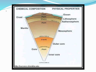
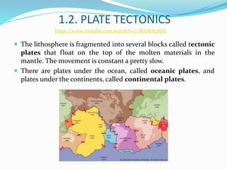
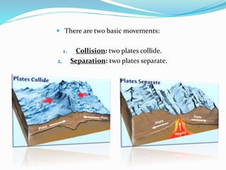
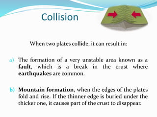
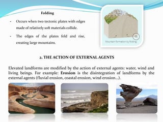
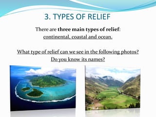
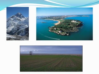
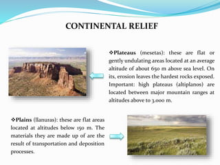
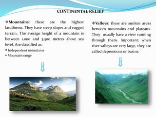
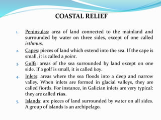
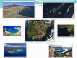
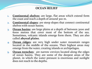
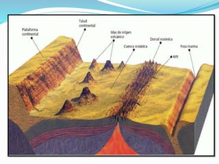
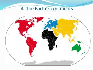
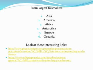
How to do quick user assign in kanban in Odoo 17 ERP
Geosphere
1.
2. INDEX
1. The internal structure of the Earth.
1.1. The Geosphere.
1.2. Plate tectonics.
2. Relief formation.
2.1. Internal forces.
2.2. External agents.
3. Types of relief.
3.1. Continental relief.
3.2. Coastal relief.
3.3. Ocean relief.
4. The Earth´s continents.
3. 1. THE INTERNAL STRUCTURE OF THE
EARTH
https://youtu.be/faXNNHcyXXk
4. 1.1. THE GEOSPHERE
According to their chemical composition, it
is divided into three layers:
Crust: it is the outermost and thinnest
layer. It is made up of rock and it is
divided into oceanic and continental
crust.
Mantle: it is the largest layer and
contains magma (mixture of molten and
semi-molten rock that is extremely hot).
When magma is ejected by a volcano, is
called lava.
Core: the innermost layer. It is believed it
is made up of heavy minerals, such as
iron and nickel in a solid or viscous state.
According to the rigidity of the materials,
it is divided also into three layers:
Lithosphere: composed of the crust and
upper mantle. Mainly solid and rigid.
Mesosphere: lower mantle. Made up of
molten materials (magma).
Endosphere: another name of the core.
Remember that Geosphere is the solid part of the Earth. It is made up of rocks
and other solid elements.
6. 1.2. PLATE TECTONICS
The lithosphere is fragmented into several blocks called tectonic
plates that float on the top of the molten materials in the
mantle. The movement is constant a pretty slow.
There are plates under the ocean, called oceanic plates, and
plates under the continents, called continental plates.
https://www.youtube.com/watch?v=7-MzoUR3R6E
7. There are two basic movements:
1. Collision: two plates collide.
2. Separation: two plates separate.
8. Collision
When two plates collide, it can result in:
a) The formation of a very unstable area known as a
fault, which is a break in the crust where
earthquakes are common.
b) Mountain formation, when the edges of the plates
fold and rise. If the thinner edge is buried under the
thicker one, it causes part of the crust to disappear.
9. Separation
When two plates separate:
This create a fissure where the magma from inside the
Earth comes up to the surface.
When lava cools, it forms a new layer of crust, called
ridge or mountain range.
https://www.youtube.com/watch?v=tcPghqnnTVk
10. THEORY OF CONTINENTAL DRIFT
Wegener’s theory, the first step to theory of tectonic plates
Alfred Wegener (1880 - 1930)
Alfred Wegener proposed the theory of continental drift at
the beginning of the 20th century (1915). His idea was that
the Earth's continents were once joined together, but
gradually moved apart over millions of years. It offered an
explanation of the existence of similar fossils and rocks on
continents that are far apart from each other. But it took a
long time for the idea to become accepted by other
scientists.
For more information:
http://kids.britannica.com/comptons/art-182286/Biological-and-geological-
similarities-between-continents-provide-evidence-of-continental
11. 2. RELIEF FORMATION
The relief formation is the result of:
1. The internal forces of the Earth (orogenesis).
2. The action of external agents.
1. INTERNAL FORCES.
Are the cause of the formation of elevated landforms
(mountains).
This process is called OROGENESIS. We can identify four
process in orogenesis:
Volcanic mountain formation (orogenia volcánica).
Fault-block mountain formation (orogenia por falla).
Mountain formation by folding (orogenia por plegamiento).
12. Volcanic mountain formation
- Occurs when two tectonic plates separate,
creating a ridge.
- Magma erupts from the volcano.
- This lava cools and solidifies, forming
mountain ranges and volcanic cones.
Fault blocks
- Occur when forces act on blocks of hard
materials which cannot fold.
- These forces produce earthquakes, which
break up the blocks.
- This forms a relief made of raised and
lowered blocks.
13. Folding
- Occurs when two tectonic plates with edges
made of relatively soft materials collide.
- The edges of the plates fold and rise,
creating large mountains.
2. THE ACTION OF EXTERNAL AGENTS
Elevated landforms are modified by the action of external agents: water, wind and
living beings. For example: Erosion is the disintegration of landforms by the
external agents (fluvial erosion, coastal erosion, wind erosion…).
14. 3. TYPES OF RELIEF
There are three main types of relief:
continental, coastal and ocean.
What type of relief can we see in the following photos?
Do you know its names?
15.
16. CONTINENTAL RELIEF
Plateaus (mesetas): these are flat or
gently undulating areas located at an average
altitude of about 650 m above sea level. On
its, erosion leaves the hardest rocks exposed.
Important: high plateaus (altiplanos) are
located between major mountain ranges at
altitudes above to 3.000 m.
Plains (llanuras): these are flat areas
located at altitudes below 150 m. The
materials they are made up of are the
result of transportation and deposition
processes.
17. CONTINENTAL RELIEF
Valleys: these are sunken areas
between mountains and plateaus.
They usually have a river running
through them. Important: when
river valleys are very large, they are
called depressions or basins.
Mountains: these are the highest
landforms. They have steep slopes and rugged
terrain. The average height of a mountain is
between 1.000 and 3.500 metres above sea
level. Are classified as:
Independent mountains
Mountain range
18. COASTAL RELIEF
1. Peninsulas: area of land connected to the mainland and
surrounded by water on three sides, except of one called
isthmus.
2. Capes: pieces of land which extend into the sea. If the cape is
small, it is called a point.
3. Gulfs: areas of the sea surrounded by land except on one
side. If a golf is small, it is called bay.
4. Inlets: areas where the sea floods into a deep and narrow
valley. When inlets are formed in glacial valleys, they are
called fiords. For instance, in Galician inlets are very typical:
they are called rías.
5. Islands: are pieces of land surrounded by water on all sides.
A group of islands is an archipelago.
19.
20. OCEAN RELIEF
1. Continental shelves: are large, flat areas which extend form
the coast and reach a depth of around 300 m.
2. Continental slopes: are steep slopes that connect continental
shelves with ocean basins.
3. Ocean basins: are large plains at a depth of between 3000 and
6000 metres that cover most of the bottom of the sea.
Sometimes, volcanic islands emerge form them. They are also
called abyssal plains.
4. Ocean ridges: are very high under water mountain ranges
located in the middle of the oceans. Their highest areas may
emerge from the water, creating islands or archipelagos.
5. Ocean trenches: are narrow crevices located along the edges
of ocean basins. They are some of the deepest areas of the
planet, in which the water pressure is enormous and sunlight
does not reach to the depths.
23. From largest to smallest
1. Asia
2. America
3. Africa
4. Antarctica
5. Europe
6. Oceania
Look at these interesting links:
http://www.pequetiempo.com/pequetiempos/encontrar-
por/aprender-sobre/%C2%BFcu%C3%A1ntos-continentes-hay-en-la-
tierra-1
https://www.saberespractico.com/estudios/cultura-
general/%C2%BFcuantos-continentes-hay-y-cuales-son/