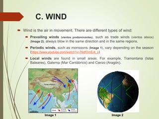
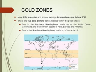
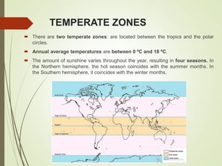
The document provides information about the key concepts that will be covered in the second term of a geography course. It includes six units of study: Unit 5 on the atmosphere, weather, and climate; Unit 6 on Earth's biomes; and Unit 1 on prehistory. For Unit 5, the document outlines the key topics that will be covered, including the layers of the atmosphere, the properties of air, atmospheric dynamics, weather factors, the Earth's climates and climate zones, and climates of Spain. Interactive exercises and a climograph activity are also mentioned.
Grade 6. chapter 5. realms of the earth..
The Earth divided into 4 realms which are interconnected.
The names of the 4 spheres have been derived from Greek words for stone (litho), air (atmo), water (hydro), and life (bio)
The layer of the gas that surrounds the Earth is called atmosphere.
The atmosphere protects Earth from absorbing the harmful ultraviolet rays of the Sun.
It also acts as a blanket around the Earth.
In this lesson, you will learn about the climate in advance. This is a very interesting lesson that you will have memories about in all school levels that you were in. You will learn a new thing in this lesson that you didn`t learn it before. In this lesson, you will learn types, influences, zones, and factors of climate and etc. This presentation has so many slides because I want to show you many things that I like about climate.
This is a presentation by Dada Robert in a Your Skill Boost masterclass organised by the Excellence Foundation for South Sudan (EFSS) on Saturday, the 25th and Sunday, the 26th of May 2024.
He discussed the concept of quality improvement, emphasizing its applicability to various aspects of life, including personal, project, and program improvements. He defined quality as doing the right thing at the right time in the right way to achieve the best possible results and discussed the concept of the "gap" between what we know and what we do, and how this gap represents the areas we need to improve. He explained the scientific approach to quality improvement, which involves systematic performance analysis, testing and learning, and implementing change ideas. He also highlighted the importance of client focus and a team approach to quality improvement.
The Art Pastor's Guide to Sabbath | Steve ThomasonSteve Thomason
What is the purpose of the Sabbath Law in the Torah. It is interesting to compare how the context of the law shifts from Exodus to Deuteronomy. Who gets to rest, and why?
Operation “Blue Star” is the only event in the history of Independent India where the state went into war with its own people. Even after about 40 years it is not clear if it was culmination of states anger over people of the region, a political game of power or start of dictatorial chapter in the democratic setup.
The people of Punjab felt alienated from main stream due to denial of their just demands during a long democratic struggle since independence. As it happen all over the word, it led to militant struggle with great loss of lives of military, police and civilian personnel. Killing of Indira Gandhi and massacre of innocent Sikhs in Delhi and other India cities was also associated with this movement.
1. Remembering the last term…
UNIT 1. PLANET EARTH
UNIT 2. GEOSPHERE
UNIT 3. HYDOSPHERE
UNIT 4. EARTH SURFACE AND WATER DISTRIBUTION
… To continue with the second term
UNIT 5. ATMOSPHERE: WEATHER AND CLIMATE
Photocopies, presentation, activities.
Voluntary activity: weather forecasting.
UNIT 6. EARTH´S BIOMES
Cooperative work.
Photocopies Biomes in Spain, activity.
Exam 5-6: 22/02/2019
_____________________________________________________
___
UNIT 1. PREHISTORY
2. UNIT 5.
ATMOSPHERE:
WEATHER AND
CLIMATE
1. The Earth´s Atmosphere.
2. The properties of air.
3. Atmospheric dynamics: weather and climate.
4. The Earth´s climates.
5. Climates of Spain.
3. Commentary text
Read the text you have on page 83 and answer the following questions:
1. What expression is used by English speakers when it is raining a lot?
Translate it into Spanish language.
2. Is there any evidence that shows that the phrase is or can be real?
Justify your answer, copying the part of the text that prove your answer.
3. There have been reports of animals falling from the sky. Name the two
weather phenomena responsible for this.
4. What is the difference between a tornado and waterspout?
5. What meteorological phenomenon occurs when warm air rises and
cools quickly?
6. Look at the pictures you have on pages 82 and 83 and write the name
and location on the world of the following meteorological phenomena:
“It is characterized by strong winds that carry out small particles of sand”
POSSIBLE UNKNOWN WORDS: Heavily (very much), waterspouts (tromba
marina o manga de agua; is like a tornado over the water), vortex (centre of
the waterspout), suck up (succionar), updrafts (corriente de aire
ascendente), pick up (recoger. levantar), debris (restos)
4. 1. THE EARTH´S ATMOSPHERE
Remember: the Earth´s atmosphere is a gaseous layer that surrounds
the planet, provides oxygen and protects us from solar radiation.
The atmosphere is divided into
different layers:
1. Troposphere
2. Stratosphere
3. Mesosphere
4. Thermosphere (Ionosphere)
5. Exosphere.
Most meteorological
phenomena, such as cloud
formation, wind and rain occur
in Troposphere.
5. The layers of the atmosphere
1. Troposphere (0-12 Km)
The main meteorological phenomena happen here.
It is the closest layer to Earth's surface.
It is the layer we live in.
higher altitude=colder temps (temperatures drop by 0, 65 ºC for every 100 m of altitude).
2. Stratosphere (12-50 km).
Ozone layer is here. It absorbs ultraviolet radiation from the sun.
Higher altitude=warmer temps.
3. Mesosphere (50-100 km)
Where meteors and comets are destroyed
higher altitude=colder temps (temperatures sometimes reach -100 ºC).
4. Thermosphere (Ionosphere) (85-600 km)
Solar radiation produces electrically-charged.
Borealis auroras are here.
Higher altitude=warmer temps (reach up to 1500 ºC).
5. Exosphere (600-10.000 km).
The outermost layer, where satellites orbit Earth.
6. 2. THE PROPERTIES OF AIR
Composition of gases. Air is a mixture of gases: 78%
nitrogen, 21% oxygen and various other components such as
water vapour.
Temperature.
Warm air (lower levels) weighs less (became lighter)and rises.
Cool air (higher levels) weighs more (became heavier) and
decreases or fall down.
Atmospheric pressure. Is the term used to describe the
pressure exerted on Earth by the weight of the air. It is
measured with a barometer.
Both altitude and temperature determine atmospheric pressure.
Relatively humidity. It refers to the amount of water vapour
that air contains. When water vapour begins to condense into
droplets, clouds are formed.
8. 3. ATMOSPHERIC DYNAMICS
3.1. WEATHER AND CLIMATE
The Sun´s rays warm up the atmosphere and our planet´s surface.
The energy from the Sun is responsible for the Earth´s weather and
climate.
You have to distinguish these two concepts:
Weather is the state of the lower layers of the atmosphere at a
certain time and place on Earth.
The science that deals with predicting what the weather will be like in a
certain zone is called Meteorology.
Climate refers to the state of the weather in a certain region of the
planet over a long period of time. It is necessary to analyze a
region in 30 years intervals to establish the climate of a region.
The science that studies different types of climate is referred to
as Climatology.
9. 3.2.FACTORS THAT INFLUENCE
WEATHER
Weather can be determined by many factors:
A. ATMOSPHERIC PRESSURE.
B. TEMPERATURE.
C. WIND.
D. HUMIDITY AND PRECIPITATION
https://study.com/academy/lesson/temperature-clouds-wind-humidity-on-
the-atmospheric-cycle.html
10. A. ATMOSPHERIC PRESSURE
Atmospheric pressure is the weight of air over a particular Earth´s
surface. It is measured in hectopascals (hPa).
It varies from one place to another and depends on:
Altitude: atmospheric pressure
is lower at higher altitudes. For
example, the amount of air at the
top of a mountain is less than at
the base.
Temperature: warm air weighs
less than cold air. As a result:
warm air rises and exerts
less pressure on the Earth´s
surface,
while cold air descends and
exerts more pressure.
11. Weather maps
Atmospheric pressure can be represented on a map, where the points of equal
atmospheric pressure are joined through a few lines: isobars. When isobars
are close together, in this area is very windy.
You can see A (Anticiclón. In English language H: high pressure area) and B
(Borrasca. In English language L: low pressure area or depressions).
In Spain there is an area of high pressure (more than 1013 hPa), so the
weather is stable. However, in Northern Europe there is an area of low
pressure (less than 1013 pHa), so the weather is unstable.
Anticyclones (H): are areas of high
pressure (more than 1013 hPa).
They produce stable weather.
Depressions (L): are areas of low
pressure (less than 1013 hPa). They
produce unstable weather.
12. B. TEMPERATURE
It is measured in degrees on the Fahrenheit (ºF) or Celsius (ºC) scales by a
thermometer.
Temperature varies according to:
Altitude: temperatures decreases with elevation (temperatures drop by
0, 65 ºC for every 100 m of altitude).
Latitude: temperatures decrease as you move away from the equator.
Sun rays go directly over the equator areas, so temperatures are higher. In polar
regions are colder because the Sun´s rays are dispersed over a larger area of land.
Distance from the sea: water heats and cool more slowly than the land does;
temperature of the land near large bodies of water is often milder, with no big
variations in temperature.
13. D. HUMIDITY AND
PRECIPITATION All air masses contain a certain amount of water vapour.
When the water vapaur falls down to the Earth = Precipitation (rain,
snow, hail).
There are three main causes or types of precipitation (page 87):
Frontal rainfall (lluvias de frente). Image 1
Storms (lluvias de convección). Image 2
Relief rainfall (lluvias de relieve/orográficas). Image 3
Image 1 Image 2 Image 3
14. C. WIND
Wind is the air in movement. There are different types of wind:
Prevailing winds (vientos predominantes), such as trade winds (vientos alisios)
(Image 2), always blow in the same direction and in the same regions.
Periodic winds, such as monsoons (Image 1), vary depending on the season
(https://www.youtube.com/watch?v=76dfOmEr4_s)
Local winds are found in small areas. For example, Tramontana (Islas
Baleares), Galerna (Mar Cantábrico) and Cierzo (Aragón).
Image 2Image 1
16. 4. THE EARTH´S CLIMATES
Climatologists divide the Earth into different climate zones.
4.1. THE EARTH´S CLIMATES ZONES.
We can identify three major climates zones: cold, hot and temperate.
17. COLD ZONES
Very little sunshine and annual average temperatures are below 0 ºC.
There are two cold climate zones located within the polar circles:
One in the Northern Hemisphere, made up of the Arctic Ocean,
Greenland and the northern coasts of Asia, Europe and America.
One in the Southern Hemisphere, made up of the Antarctic.
18. HOT ZONES
There is a single hot climate zone, which is known as the
intertropical zone: It is located between the two tropics.
The intense sunshine in this region produces annual average
temperatures of above 18 ºC.
19. TEMPERATE ZONES
There are two temperate zones: are located between the tropics and the polar
circles.
Annual average temperatures are between 0 ºC and 18 ºC.
The amount of sunshine varies throughout the year, resulting in four seasons. In
the Northern hemisphere, the hot season coincides with the summer months. In
the Southern hemisphere, it coincides with the winter months.
20. 4.2. THE EARTH´S CLIMATES TYPES
Within climates zones there are regions with different types of
climates.
The combination of annual temperature and precipitation data
results in nine different climate types:
CLIMATE
TYPES
TEMPERATE
CLIMATES
Mediterranean Continental Oceanic
Humid
Subtropical
HOT CLIMATES
Equatorial Tropical Desert
COLD CLIMATES
Polar Alpine
22. WHAT IS A CLIMOGRAPH?
Temperature and precipitation make it possible to identify a
climate.
Both elements can be shown graphically using a
climograph which allows us to observe the annual change
in temperature and precipitation in a specific place on the
planet.
This information is represented using a combination chart
with two systems of coordinates.
Activity: How to make a climopraph (page 96-97)