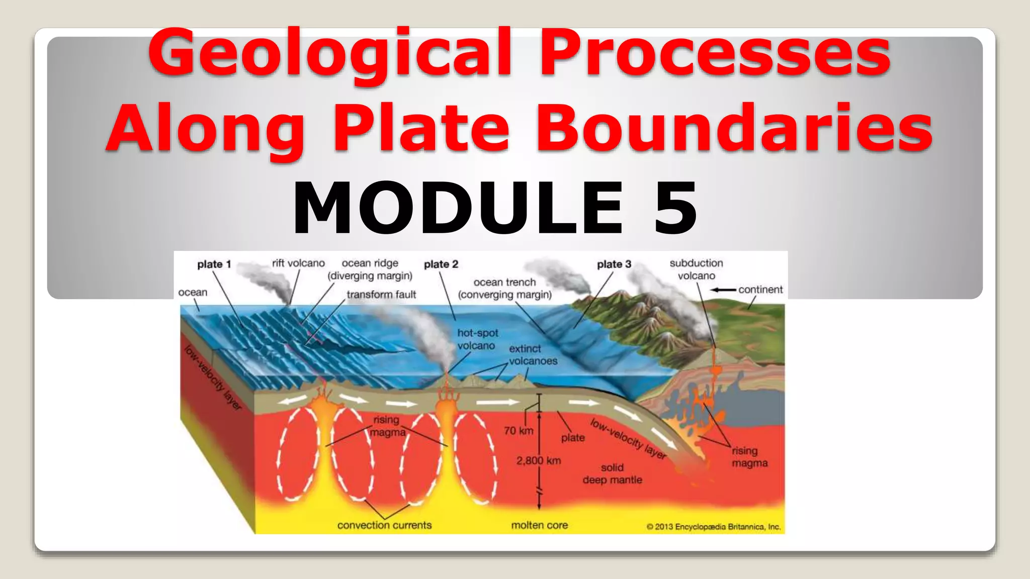
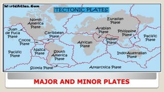
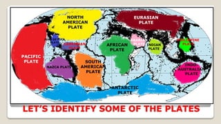
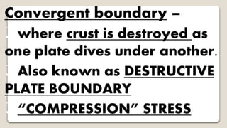
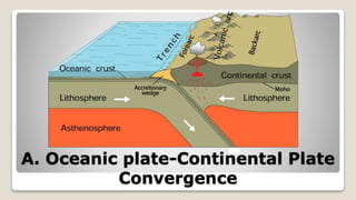
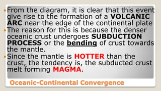
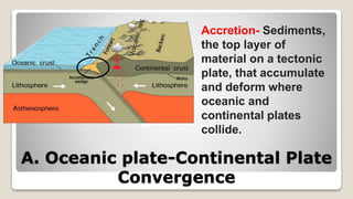
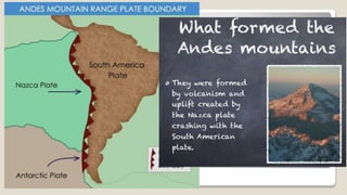
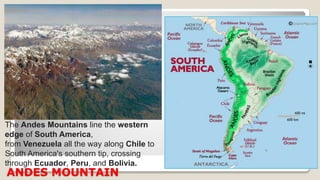
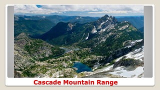
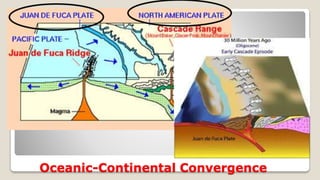
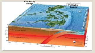
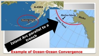
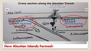
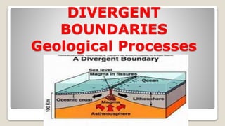
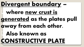
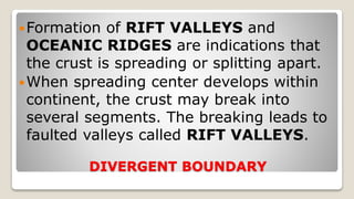
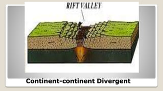
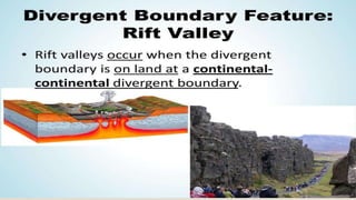
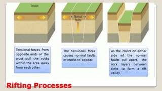
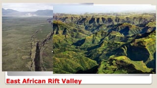
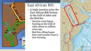
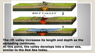
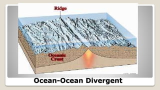
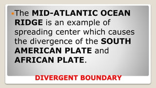
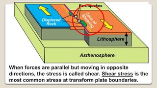
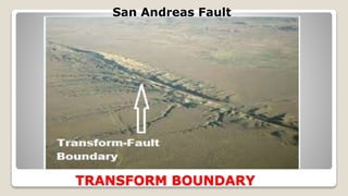
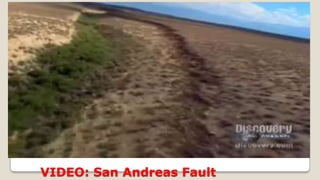
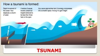
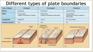
This ppt is about Geologic events and Geologic features found along the plate boundaries. This PowerPoint is a lesson, especially for grade 10 students and teachers. This will help you understand topographies occur along plate boundaries.
Download the lesson exemplar so you can follow this ppt. I have uploaded the lesson plan on this presentation too. Please search continental drift theory LP
if videos do not play, here are the links
https://www.youtube.com/watch?v=WaUk94AdXPA
https://www.youtube.com/watch?v=UwWWuttntio
Download the lesson exemplar so you can follow this ppt. I have uploaded the lesson plan on this presentation too. Please search continental drift theory LP
if videos do not play, here are the links
https://www.youtube.com/watch?v=WaUk94AdXPA
https://www.youtube.com/watch?v=UwWWuttntio
Lecture 4 Outline Plate Tectonics – Mechanisms and MarginsL.docxSHIVA101531
Lecture 4 Outline:
Plate Tectonics – Mechanisms and Margins
Learning Objectives:
What are the types of plate boundaries?
What processes occur at different types of plate boundaries?
What are hotspots?
How does tectonics build continents and ocean basins?
What Happens at Plate Boundaries?
Plate interiors stable - geologic activity limited to surface processes
But interactions between plates at plate boundaries results in
Magma and volcanism
Faulting and earthquakes
Mountain building
Production of new crust
Recycling of old crust
What are the Types of Plate Boundaries?
Divergent
plates pulled apart
Convergent
plates collide
Transform
plates sheared
Each plate surrounded by different types of boundaries
What are the Types of Plate Boundaries?
What are Divergent Plate Boundaries?
Ridges
Crust pulled apart
Magma by decompression melting in asthenosphere
Cools to make new oceanic crust
Oceanic crust
lithosphere
asthenosphere
magma
central rift valley
faults
North Atlantic Ridge
Mid-Atlantic Ridge
East Pacific Ridge
Indian Ridge
Antarctic Ridge
Where are Divergent Plate Boundaries Found?
Ocean ridge above sea level in Iceland
Where are Divergent Plate Boundaries Found?
What are the Major Geologic Features of the Ocean Ridge?
Shield Volcano
Edge of North American Plate
Fault
Down-dropped fault block
Central rift valley
Filled by lava flows
What are Convergent Plate Boundaries?
Two plates collide with each other – two types
Subduction zone
Between two plates of different density - denser plate subducted
melting in mantle by addition of water from subducted plate
Trench and volcanic arc - chain of volcanoes on overriding plate
Earthquakes
What are Convergent Plate Boundaries?
Collision zone
between plates too buoyant to subduct
Crust thickened and mountains raised instead
Earthquakes but no volcanoes
Indian Plate
Eurasian Plate
Younger and weaker
Older and stronger
deformed
Which Plate gets Subducted?
If both plates composed of oceanic crust
older and denser crust subducted by younger and lighter crust
Overriding plate
Plate boundary
Where Can We Find an Example of an Oceanic Plate Subducted by Another Oceanic Plate?
Pacific Plate subducted by Philippine Plate at Mariana Trench
Pacific Plate
(older)
Philippine Plate
(younger)
Japan Trench
Mariana Trench
Challenger Deep
Eurasian Plate
Which Plate gets Subducted?
If one plate of continental crust and one of oceanic crust
denser oceanic crust subducted by lighter continental crust
Material too light to subduct added to continent as accreted terranes
sediments, volcanic islands, fragments of continental crust
Where Can We Find an Example of a Collision Zone?
Indian and Eurasian Plates
Collision began 45 mya when subduction completely closed ocean basin
Himalaya and Tibetan Plateau
Recent or continuing collisions produce Earth’s tallest mountains
50 mya
today
Closing Ocean
Spreading Ocean
14
Oblique motion betw ...
The slideshow discusses the distribution of mountain ranges, volcanoes, and earthquake epicenters. This is the basis of the scientist in dividing the earth's lithospheric paltes or the earth's crust. This also contains the different types of plate boundaries: convergent, divergent and transform fault boundaries. The different geologic features that are formed in the plate boundaries were also discussed and the processes that occur in the different plate boundaries.
This lesson talks about another gas law, the Charles' Law. This is a simplify lesson for intended for the level of my students understanding. Hope it helps you too!
This ppt is a lecture on Boyle's Law. It contains examples and conversions. It will help you understand the concept more as I simplify the concept intended for the understanding of my science class.
Introduction to AI for Nonprofits with Tapp NetworkTechSoup
Dive into the world of AI! Experts Jon Hill and Tareq Monaur will guide you through AI's role in enhancing nonprofit websites and basic marketing strategies, making it easy to understand and apply.
Exploiting Artificial Intelligence for Empowering Researchers and Faculty, In...Dr. Vinod Kumar Kanvaria
Exploiting Artificial Intelligence for Empowering Researchers and Faculty,
International FDP on Fundamentals of Research in Social Sciences
at Integral University, Lucknow, 06.06.2024
By Dr. Vinod Kumar Kanvaria
The French Revolution, which began in 1789, was a period of radical social and political upheaval in France. It marked the decline of absolute monarchies, the rise of secular and democratic republics, and the eventual rise of Napoleon Bonaparte. This revolutionary period is crucial in understanding the transition from feudalism to modernity in Europe.
For more information, visit-www.vavaclasses.com
Embracing GenAI - A Strategic ImperativePeter Windle
Artificial Intelligence (AI) technologies such as Generative AI, Image Generators and Large Language Models have had a dramatic impact on teaching, learning and assessment over the past 18 months. The most immediate threat AI posed was to Academic Integrity with Higher Education Institutes (HEIs) focusing their efforts on combating the use of GenAI in assessment. Guidelines were developed for staff and students, policies put in place too. Innovative educators have forged paths in the use of Generative AI for teaching, learning and assessments leading to pockets of transformation springing up across HEIs, often with little or no top-down guidance, support or direction.
This Gasta posits a strategic approach to integrating AI into HEIs to prepare staff, students and the curriculum for an evolving world and workplace. We will highlight the advantages of working with these technologies beyond the realm of teaching, learning and assessment by considering prompt engineering skills, industry impact, curriculum changes, and the need for staff upskilling. In contrast, not engaging strategically with Generative AI poses risks, including falling behind peers, missed opportunities and failing to ensure our graduates remain employable. The rapid evolution of AI technologies necessitates a proactive and strategic approach if we are to remain relevant.
Macroeconomics- Movie Location
This will be used as part of your Personal Professional Portfolio once graded.
Objective:
Prepare a presentation or a paper using research, basic comparative analysis, data organization and application of economic information. You will make an informed assessment of an economic climate outside of the United States to accomplish an entertainment industry objective.
Francesca Gottschalk - How can education support child empowerment.pptxEduSkills OECD
Francesca Gottschalk from the OECD’s Centre for Educational Research and Innovation presents at the Ask an Expert Webinar: How can education support child empowerment?
6. LET’S IDENTIFY SOME OF THE PLATES
PACIFIC
PLATE
NORTH
AMERICAN
PLATE
EURASIAN
PLATE
ANTARCTIC
PLATE
SOUTH
AMERICAN
PLATE
AFRICAN
PLATE
INDO-
AUSTRALIAN
PLATE
PHILIPPINE
PLATEINDIAN
PLATE
NAZCA PLATE
CARRIBEAN
PLATE
ARABIAN
PLATE
JUAN DE FUCA
PLATE
11. Oceanic-Continental Convergence
From the diagram, it is clear that this event
give rise to the formation of a VOLCANIC
ARC near the edge of the continental plate
The reason for this is because the denser
oceanic crust undergoes SUBDUCTION
PROCESS or the bending of crust towards
the mantle.
Since the mantle is HOTTER than the
crust, the tendency is, the subducted crust
melt forming MAGMA.
12. A. Oceanic plate-Continental Plate
Convergence
Accretion- Sediments,
the top layer of
material on a tectonic
plate, that accumulate
and deform where
oceanic and
continental plates
collide.
13.
14. ANDES MOUNTAIN
The Andes Mountains line the western
edge of South America,
from Venezuela all the way along Chile to
South America's southern tip, crossing
through Ecuador, Peru, and Bolivia.
17. Oceanic-Continental Convergence
For oceanic crust, one important geologic
features formed is the TRENCH, also
called SUBMARINE VALLEYS, ocean
trenches are the deepest part of the ocean.
One of the Deepest is the PHILIPPINE
TRENCH with a depth of 10,540 meters.
Another subsequent effect of continuous
grinding of plate against each other is the
occurrence of EARTHQUAKES.
24. Oceanic plate-oceanic plate Convergence
Converging two oceanic plates will cause
formation of TRENCHES, these trenches will
become sources of earthquakes.
Underwater earthquakes, especially the stronger
ones, can generate TSUNAMIS, The Japanese
term for HARBOR WAVE.
TSUNAMIS is a series of ocean waves with very
long wavelengths ( hundreds of kilometers)
caused by a large-scale disturbances under the
ocean.
25. Oceanic plate-oceanic plate Convergence
The leading edge of the SUBDUCTED
PLATE, will eventually reach the mantle
causing it to melt and turn into MAGMA,
The molten material will rise to the surface
creating a VOLCANIC ISLAND ARC
parallel to the TRENCHES,
VOLCANIC ISLAND ARC is a chain of
volcanoes position in an arc shape.
26. FORMATION OF PHILIPPINE ARCHIPELAGO
Many parts of the Philippines originated from
oceanic-oceanic convergence.
Philippine Archipelago are considered as part
of the PHILIPPINE MOBILE BELT.
This island were formed 65 millions years ago at
the southern edge of the Philippine Sea Plate
and are considered as part of the island arcs.
Philippine Islands are formed dues to the
convergence of the Philippine Plate and the
Eurasian Plate.
29. FORMATION OF PHILIPPINE ARCHIPELAGO
Other parts of the PHILIPPINES, such as
PALAWAN, MINDORO and ZAMBOANGA
PENINSULA are all high land section of the
SUNDALAND BLOCK of the EURASIAN PLATE.
The Philippine Mobile Belt eventually collided
with the sundaland block which explains the
presence of TRENCHES, such as MANILA-
NEGROS-COTABATO TRENCH SYSTEM and
the SULU TRENCH.
34. Continental-Continental Plates Convergence
When two continental plates converge,
a COLLISION ZONE is formed.
No occurrence of SUBDUCTION.
No TRENCH, no VOLCANO and
definitely no ISLAND ARC are created.
Instead, what created is a large group
of tall mountains called MOUNTAIN
RANGE parallel to a HIGH PLATEAU.
36. Continental-Continental Plates Convergence
About 40-50 million years ago, two
large land mass, INDIA and EURASIA,
collided to begin the formation of the
most visible product of plate tectonics-
THE HIMALAYAS.
Also collision of continental plates is
associated with shallow earthquake
activities.
39. HIMALAYAN MOUNTAIN
The Himalayas stretch
across the north eastern
portion of India. They
cover approximately
1,500 mi (2,400 km) and
pass through the nations
of India, Pakistan,
Afghanistan, China,
Bhutan and Nepal.The range has many of Earth's highest peaks,
including the highest, Mount Everest, at the
border between Nepal and China
47. DIVERGENT BOUNDARY
Formation of RIFT VALLEYS and
OCEANIC RIDGES are indications that
the crust is spreading or splitting apart.
When spreading center develops within
continent, the crust may break into
several segments. The breaking leads to
faulted valleys called RIFT VALLEYS.
53. The rift valley increases its length and depth as the
spreading continues.
At this point, the valley develops into a linear sea,
similar to the Red Sea today.
57. DIVERGENT BOUNDARY
Most divergent boundaries are situated
along underwater mountain ranges
called OCEANIC RIDGES.
As the plates separates, new materials
from the mantle ooze up to fill the gap.
These materials will slowly cool to
produce NEW OCEAN FLOOR.
58. DIVERGENT BOUNDARY
The MID-ATLANTIC OCEAN
RIDGE is an example of
spreading center which causes
the divergence of the SOUTH
AMERICAN PLATE and
AFRICAN PLATE.
59. Visible surface of Mid Atlantic Ridge in Iceland
Slicing through the center of Iceland is the Mid-Atlantic Ridge. This is the
boundary between the North American and Eurasian tectonic plates.
60. Where does the Mid Atlantic Ridge surface?
In the Atlantic Ocean, the mid-
ocean ridge is called the Mid-
Atlantic Ridge. It curves from the
Arctic Ocean southward, through
Iceland, down the center of the
Atlantic, and around the bottom of
Africa.
Thingvellir National Park, in
southwestern Iceland, is one of
the few spots in the world where
an underwater ridge rises
above the water surface.
63. MID-ATLANTIC RIDGE UNDERWATER
The Silfra fissure, a popular dive and snorkel tour location, is also located
within Thingvellir National Park on the northern shore of Thingvallavatn, the
largest natural lake of Iceland. Here tourists, donning scuba gear, can dive
between the two tectonic plates.
65. WHAT IS A RIDGE?
a long narrow hilltop, mountain
range, or watershed that form a
continuous elevated crest for some
distance.
An oceanic ridge technically an
“UNDERWATER MOUNTAIN”
66. Transform boundary –
where crust is neither
produced nor destroyed as the
plates slide and grind
horizontally past each other.
Also known as CONSERVATIVE
PLATE BOUNDARY
67. When forces are parallel but moving in opposite
directions, the stress is called shear. Shear stress is the
most common stress at transform plate boundaries.
75. 1. Where do most
earthquakes happen?
A. Along the plate boundaries.
B. in the earth’s mantle
C. near the center of the tectonic
plates
D. in the earth’s core
76. 2. As a new seafloor is formed at the mid-
ocean ridge, the old seafloor farthest from
the ridge is destroyed. Which of the stated
processes describes how the oceanic crust
plunges into the earth and destroyed at the
mantle?
A. Convection
B. Construction
C. Diversion
D. Subduction
77. 3. At a convergent plate not all lithospheric
plates are made of equally dense rock,
subduction zone is a long, narrow belt where a
lithospheric plate is sinking into the mantle.
Why does the oceanic crust sink beneath the
continental crust at the subduction zone?
A. The oceanic crust have high density than the
continental crust and is pushed from the ridge.
B. The oceanic crust is pulled downward by
earth’s magnetic field.
C. The continental crust have denser composition
78. 4. What do you expect to find
parallel to a trench?
A. hot spot
B. mountain range
C. ocean ridge
D. volcanic arc
79. 5. Which island is not
associated with an oceanic-
oceanic convergent boundary
A. Aleutian Islands
C. Marianas Islands
B. Hawaii Islands
D. Philippine Islands
80. 6. Which geologic event will
NOT occur in San Andreas
Fault?
A. Strike and slip fault
B. Shallow Earthquake
C. Sliding of two plates
D. Great Tsunami
81. 7. Which geologic structure is a
piece of evidence that the
seafloor creates new ocean
floor?
A. The formation of the Red Sea
B. Expansion of the Mid Atlantic Ridge
C. Formation of Volcanic Arc
D. Formation of Trenches
82. 8. What geologic activity takes
place in a convergent
continental-continental
boundary?
A. Earthquake
B. Mountain Building
C. Seafloor Spreading
D. Volcano Forming
83. 9. What land feature is
formed at a divergent
oceanic- oceanic boundary?
A. Deep Ocean Trench
B. Pacific Hot Spot
C. Mid Ocean Ridge
D. Rift Valley
84. 10. Which of the world's
geological features is not formed
in the divergent boundary?
A. The Great Rift Valley of East
Africa
B. The San Andreas Fault
C. The East Pacific Rise
D. The Mid Atlantic Ridge
86. 1. Where do most
earthquakes happen?
A. Along the plate boundaries
B. in the earth’s mantle
C. near the center of the
tectonic plates
D. in the earth’s core
87. 2. Which of the stated processes
describes how the oceanic crust
plunges into the earth and
destroyed at the mantle?
A. Convection
B. Construction
C. Diversion
D. Subduction
88. 3. At a convergent plate not all lithospheric
plates are made of equally dense rock,
subduction zone is a long, narrow belt where a
lithospheric plate is sinking into the mantle.
Why does the oceanic crust sink beneath the
continental crust at the subduction zone?
A. The oceanic crust have high density than the
continental crust and is pushed from the ridge.
B. The oceanic crust is pulled downward by
earth’s magnetic field.
C. The continental crust have denser composition
89. 4. What do you expect to find
parallel to a trench?
A. hot spot
B. mountain range
C. ocean ridge
D. volcanic arc
90. 5. Which island is not
associated with an oceanic-
oceanic convergent boundary
A. Aleutian Islands
C. Marianas Islands
B. Hawaii Islands
D. Philippine Islands
91. 6. Which geologic event will
NOT occur in San Andreas
Fault?
A. Strike and slip fault
B. Shallow Earthquake
C. Sliding of two plates
D. Great Tsunami
92. 7. Which geologic structure is a
piece of evidence that the
seafloor creates new ocean
floor?
A. The formation of the Red Sea
B. Expansion of the Mid Atlantic
Ridge
C. Formation of Volcanic Arc
D. Formation of Trenches
93. 8. What geologic activity takes
place in a convergent
continental-continental
boundary?
A. Earthquake
B. Mountain Building
C. Seafloor Spreading
D. Volcano Forming
94. 9. What land feature is
formed at a divergent
oceanic- oceanic boundary?
A. Deep Ocean Trench
B. Pacific Hot Spot
C. Mid Ocean Ridge
D. Rift Valley
95. 10. Which of the world's
geological features is not formed
in the divergent boundary?
A. The Great Rift Valley of East
Africa
B. The San Andreas Fault
C. The East Pacific Rise
D. The Mid Atlantic Ridge
the Cascade Range is almost entirely volcanic in origin. The volcanoes and their eroded remnants are the visible magmatic expression of the Cascadia subduction zone, where the offshore Juan de Fuca tectonic plate is subducted beneath North America.
What is it like in a trench?
The great depth of ocean trenches creates an environment with water pressures more than 1,000 times greater than the surface, constant temperatures just above freezing, and no light to sustain photosynthesis. While this may not seem like conditions suitable to life, the combination of extremely high pressure, the gradual accumulation of food along trench axes, and the geographical isolation of hadal systems are believed to have created habitats with an extraordinarily high abundance of a few highly specialized organisms.
fracture is any separation in a geologic formation, such as a joint or a fault that divides the rock into two or more pieces. A fracture will sometimes form a deep fissure or crevice in the rock.
Why it is called the Red Sea? There are numerous hypotheses hovering over without certainty.
The red sea water contains red coloured cyanobacteria (Trichodesmium erythraeum) which turn the blue-green water to a reddish-brown.
2)The “Red Sea” is in fact “Sea of Reed”,( a tall slender leaved plant of the grass family growing in water or marshy area.) most likely due to the reeds of the Gulf of Suez.
A hypothesis favoured by modern scholars is that the name “red” refers direction of “South” just as the Black Sea refers to “North”. Sea’s located south of the Mediterranean world. In ancient languages, the colours black, red, green, and white referred to North, South, East, and West, respectively. Herodotus (a Greek historian who lived 484-425 BC) on one occasion uses Red Sea and Southern Sea interchangeably.
The red sea water contains red coloured cyanobacteria (Trichodesmium erythraeum) which turn the blue-green water to a reddish-brown.
Iceland represents the largest portion of the mid-Atlantic ridge exposed above sea level. Formed from volcanic eruptions on the Mid-Atlantic ridge, about 24 million years ago, it is one of the few places where you can stand on the ridge on dry land. This makes Iceland very special and a popular place for geologists and scientists.
a special case in Iceland where ridges rise above the surface