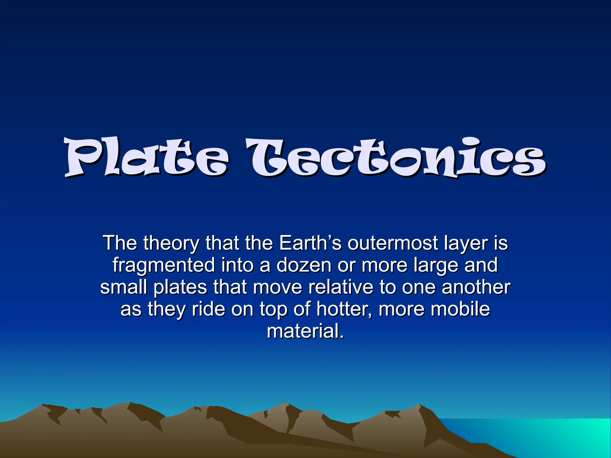
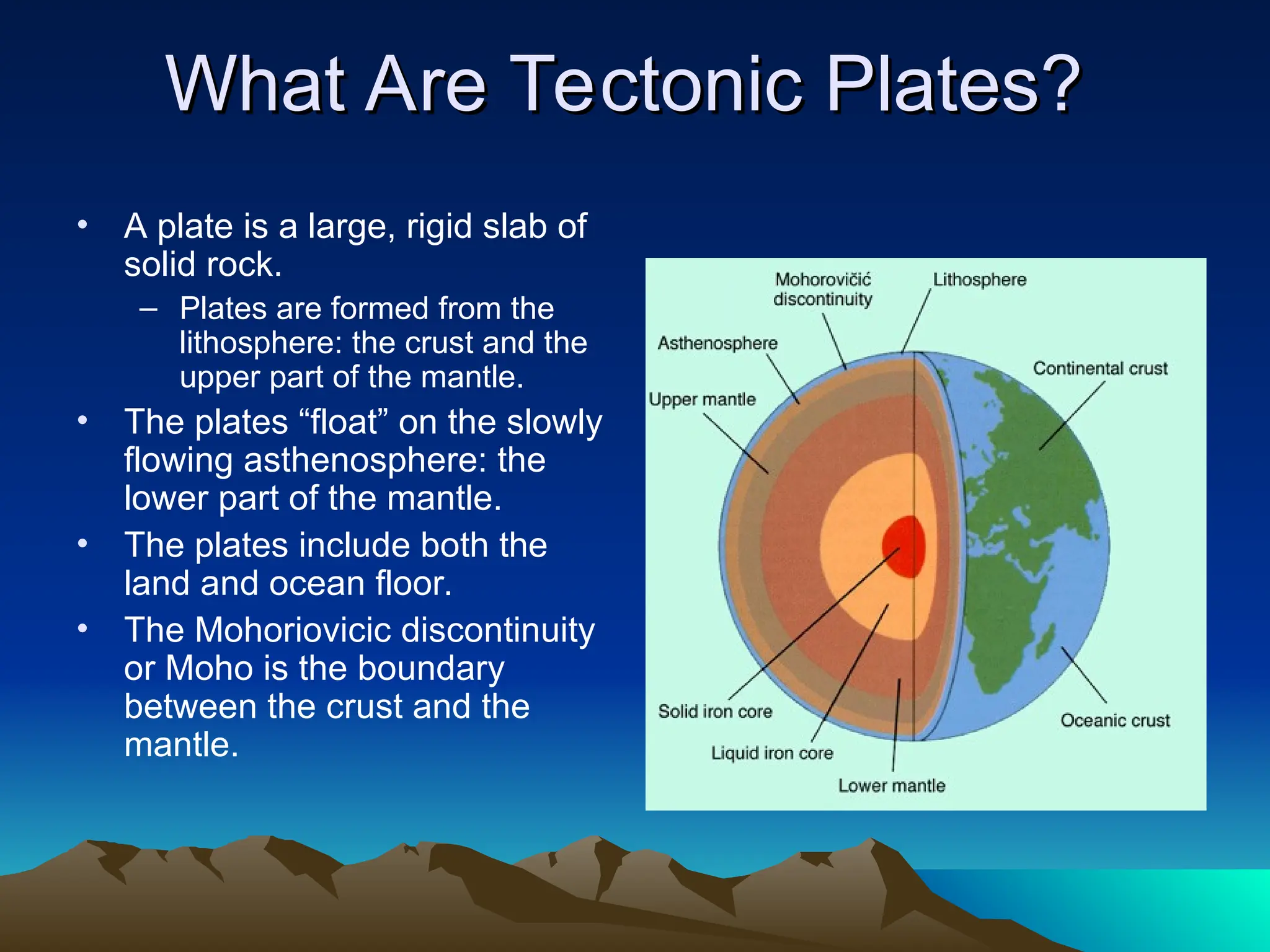
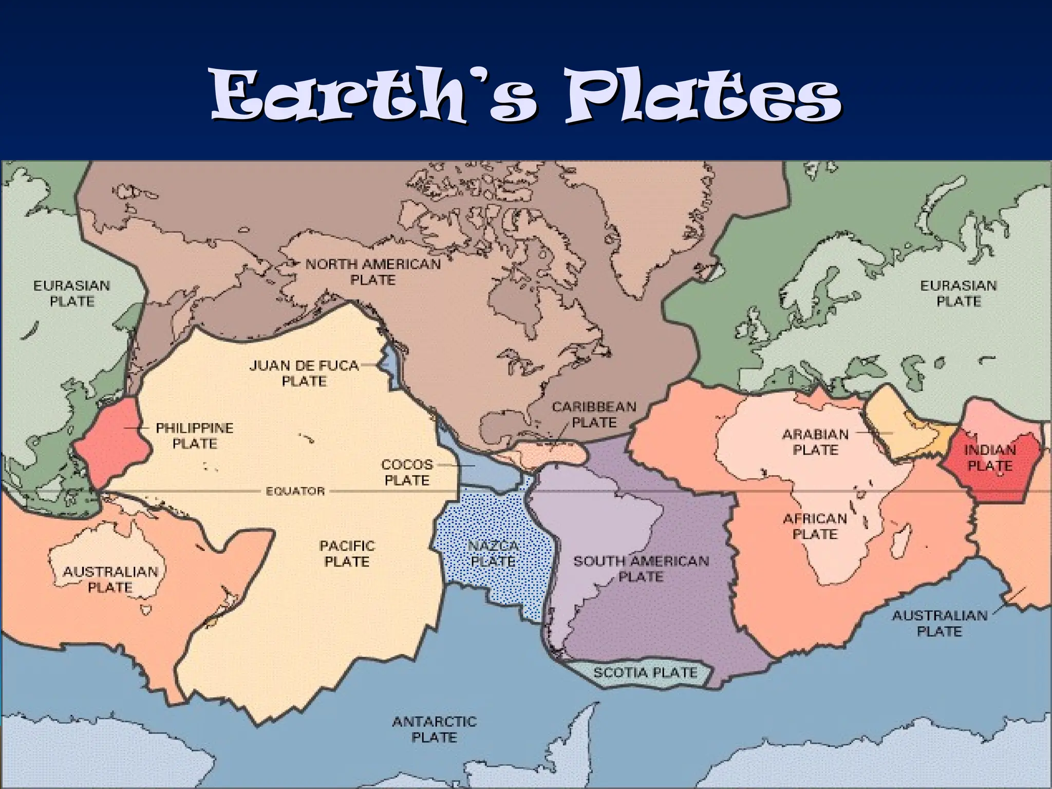
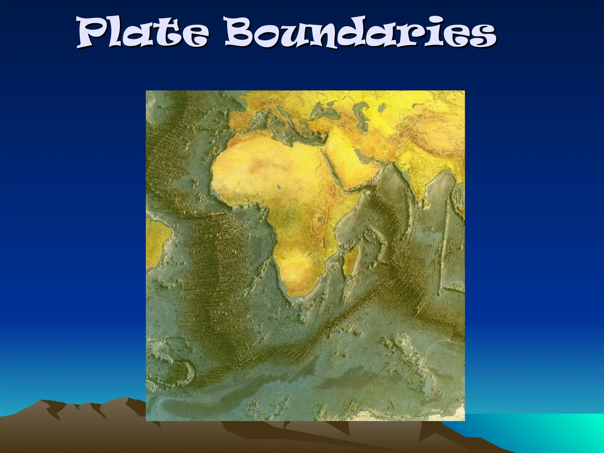
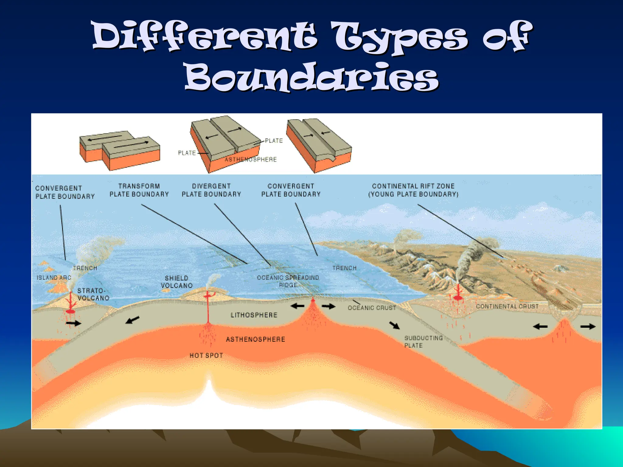
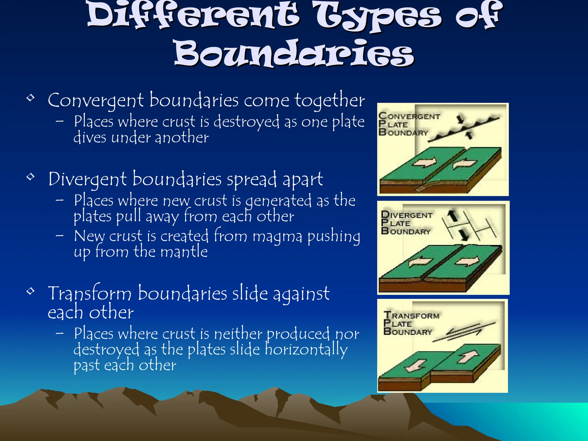
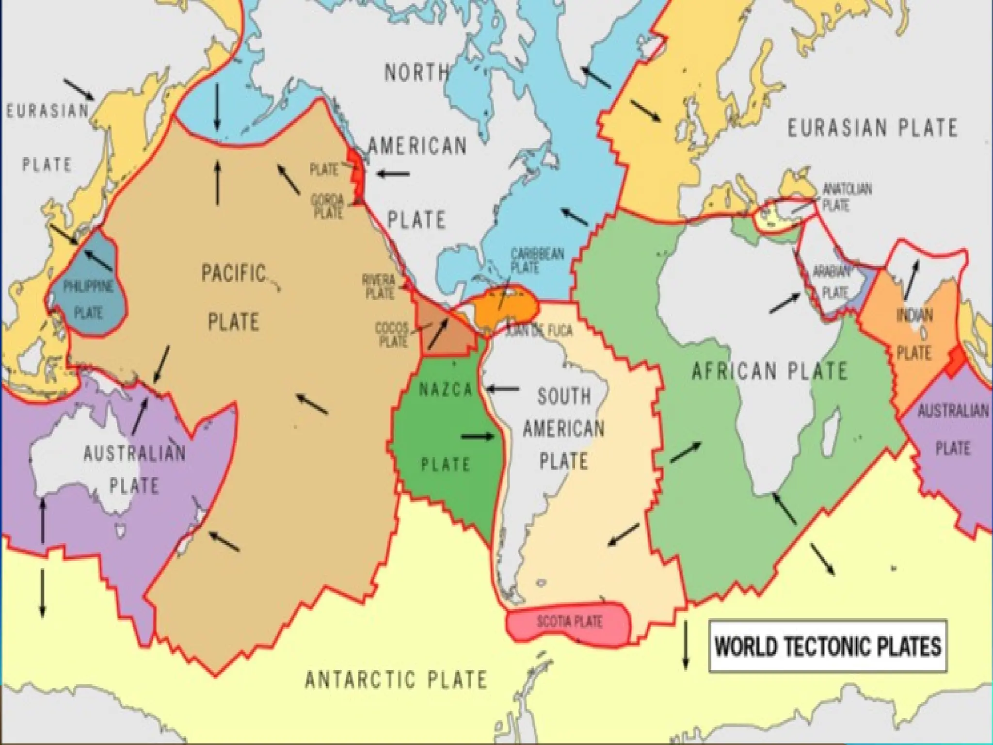
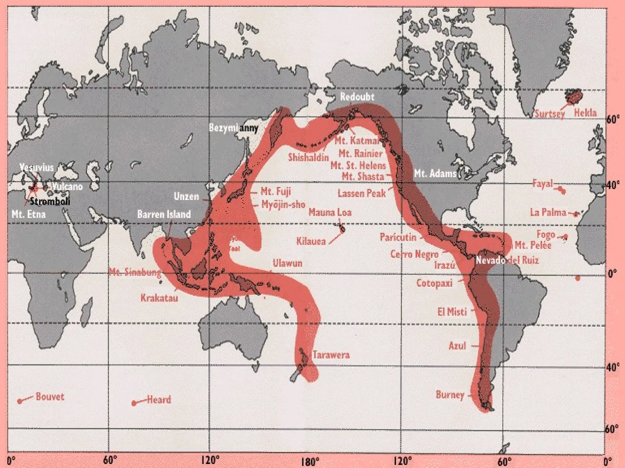
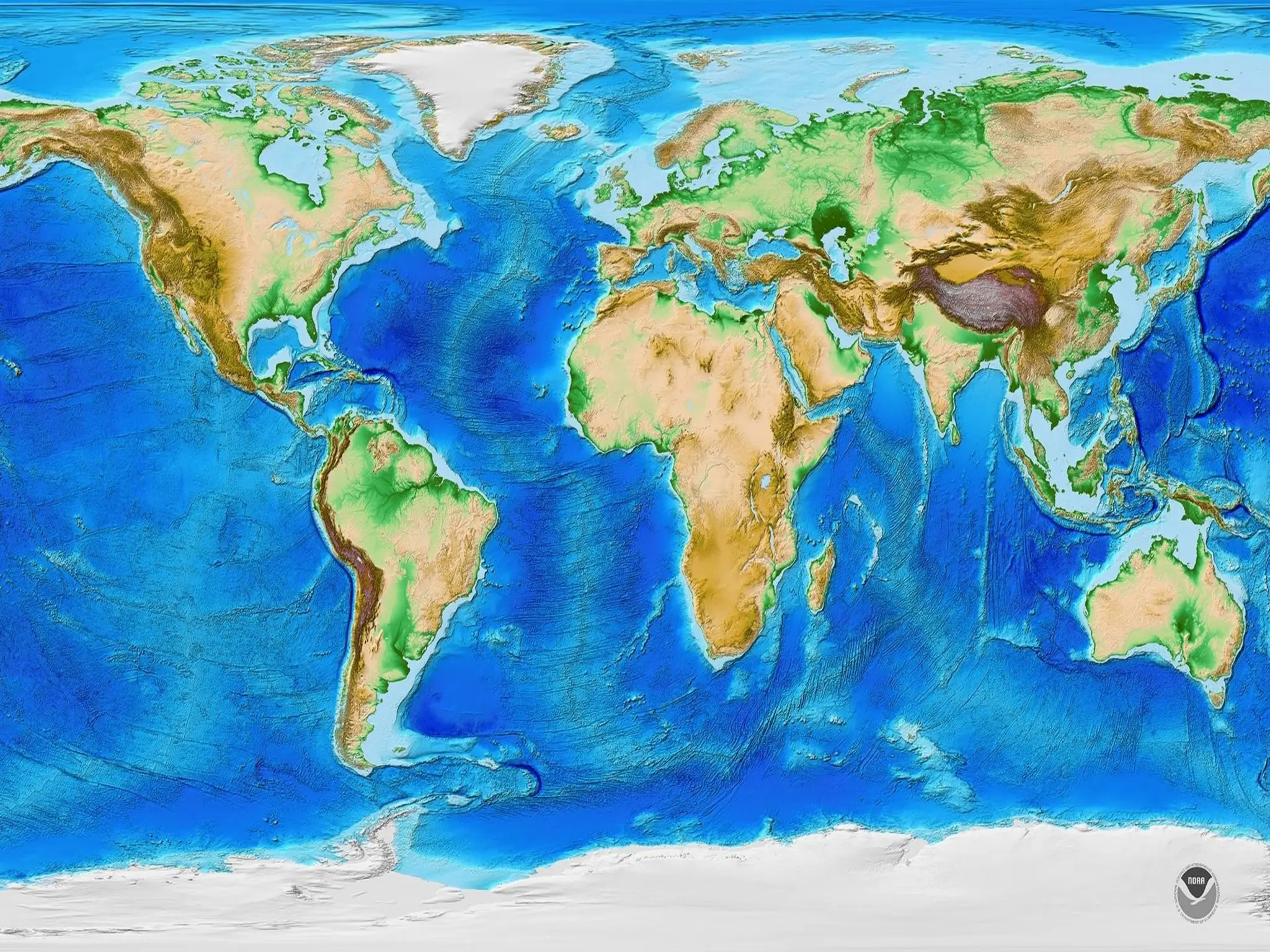
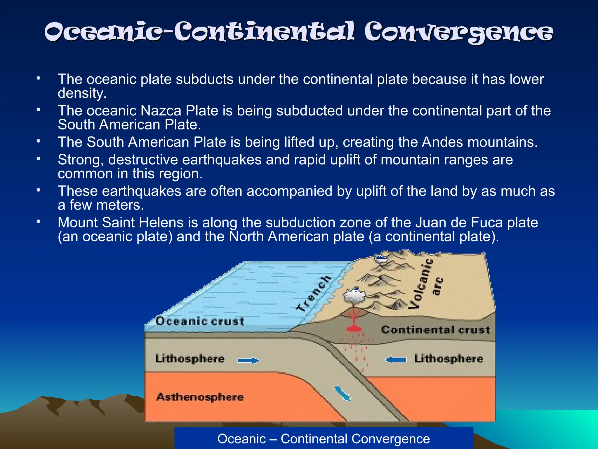
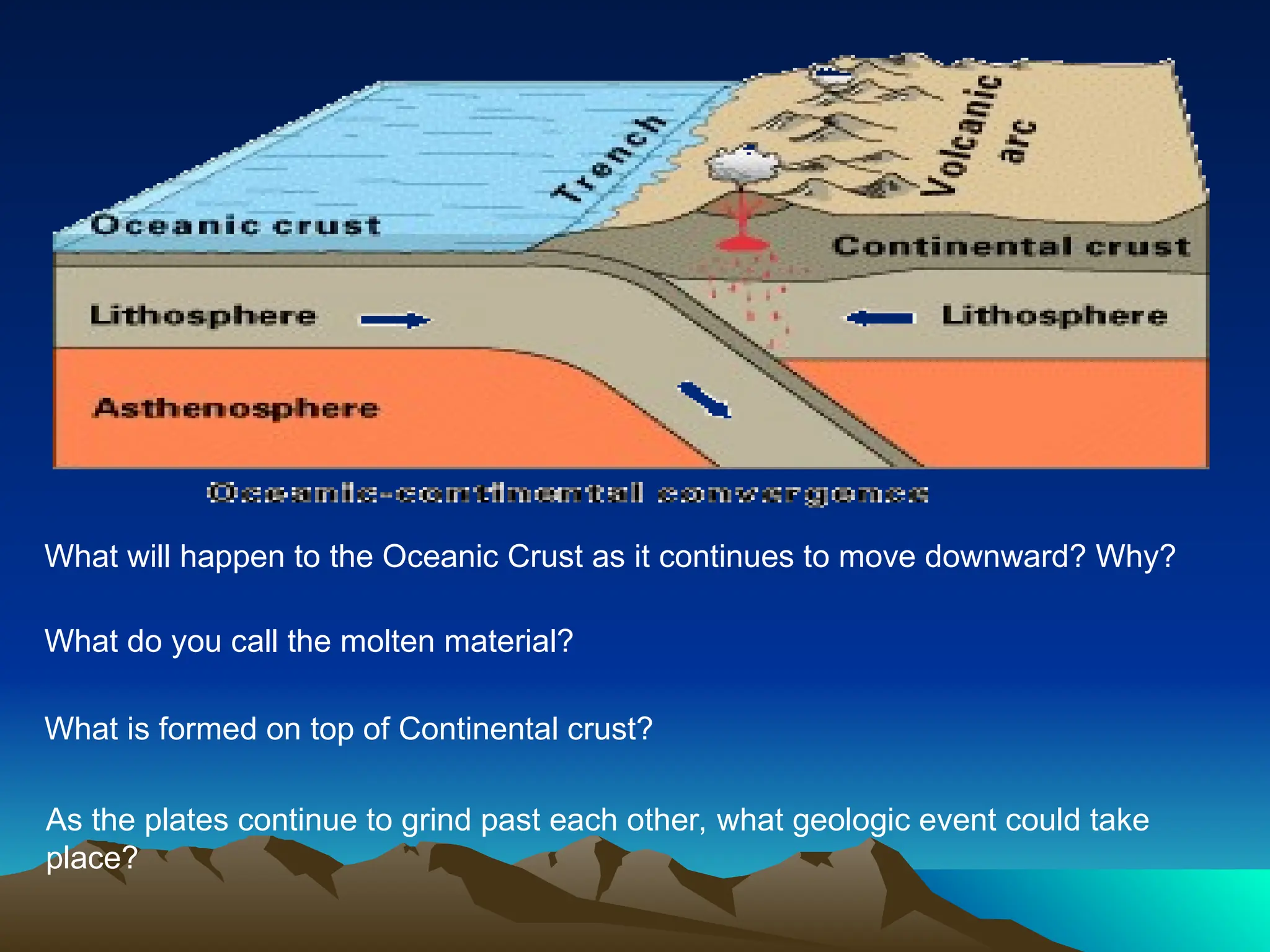
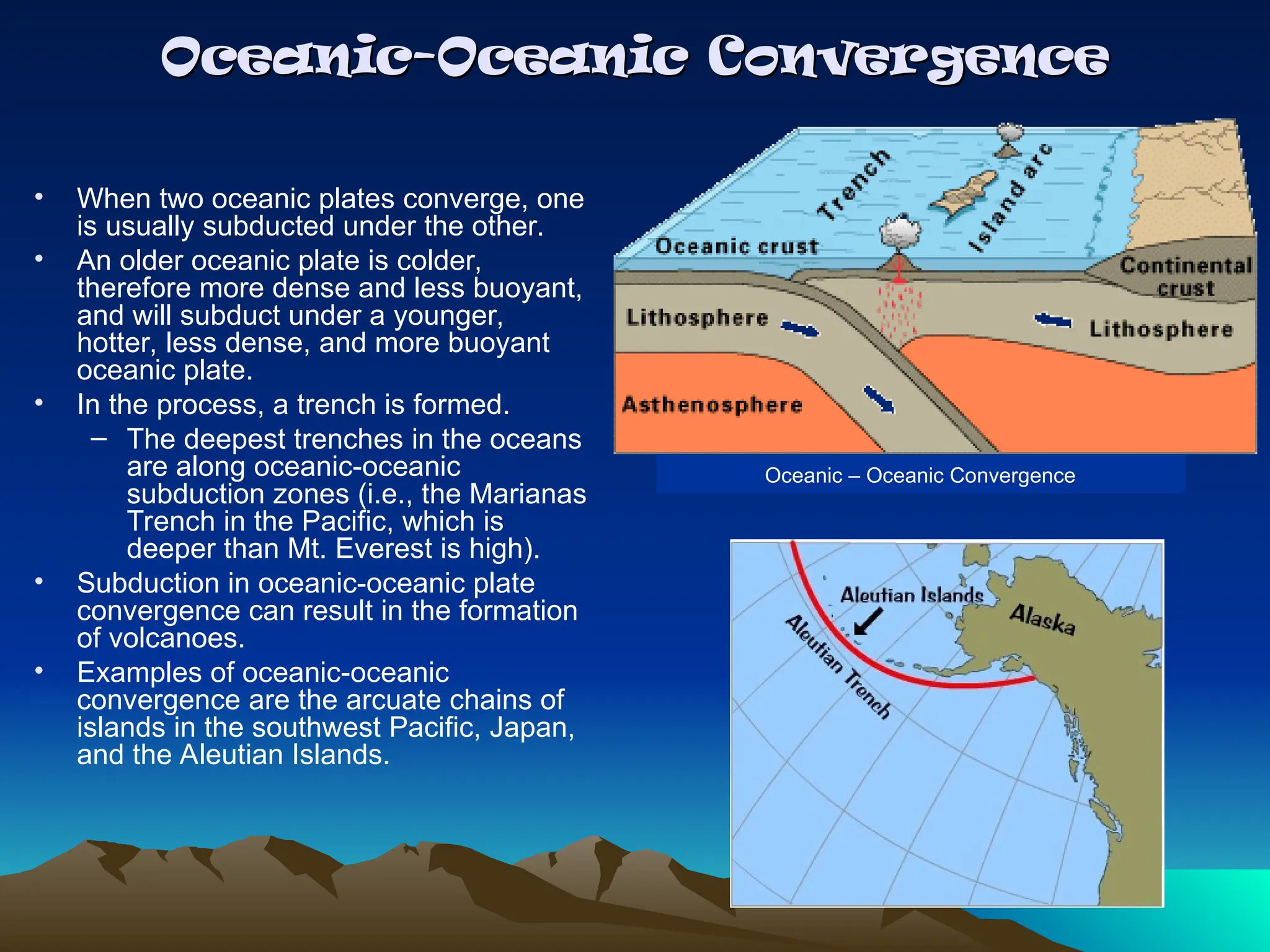
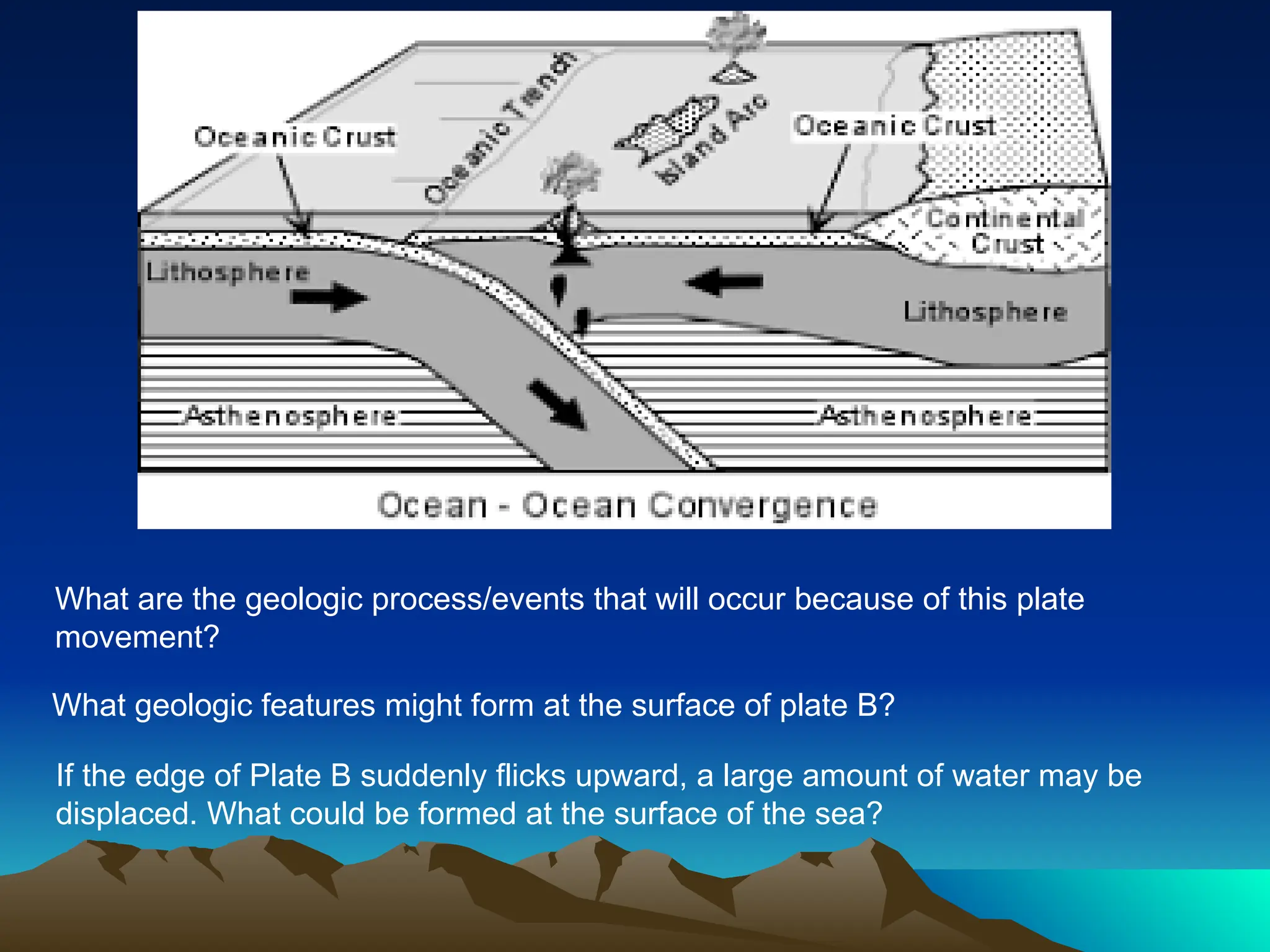
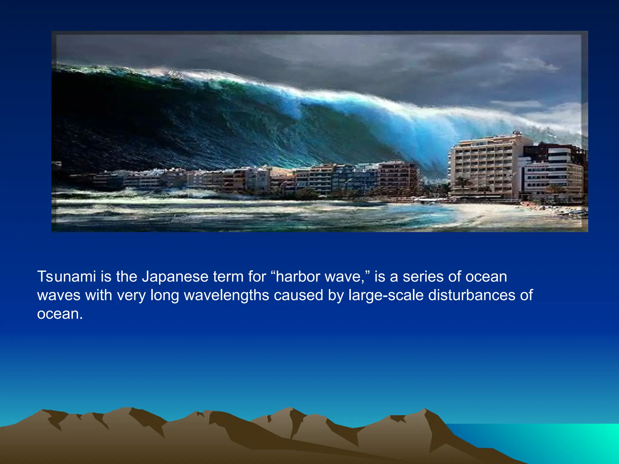
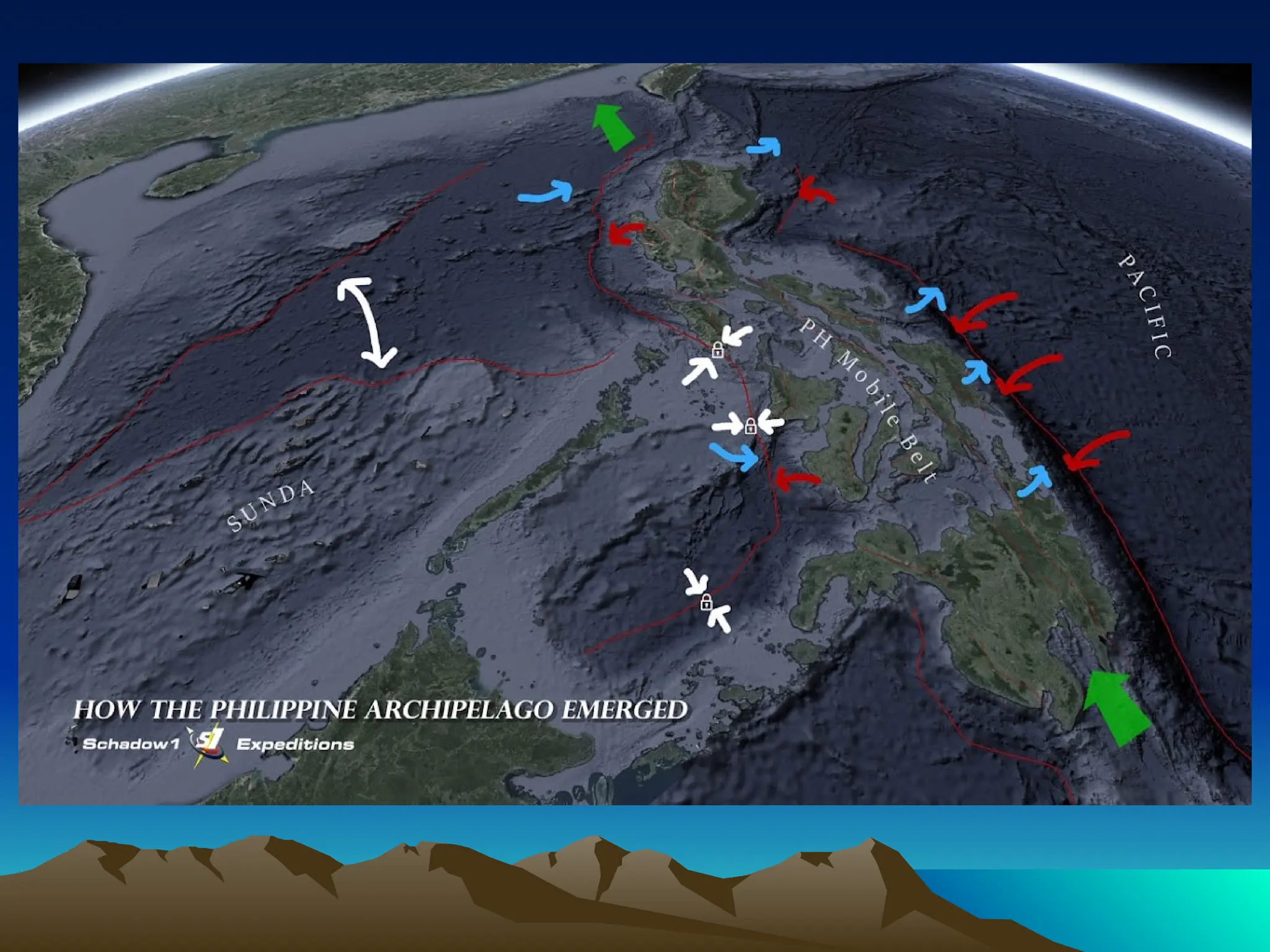
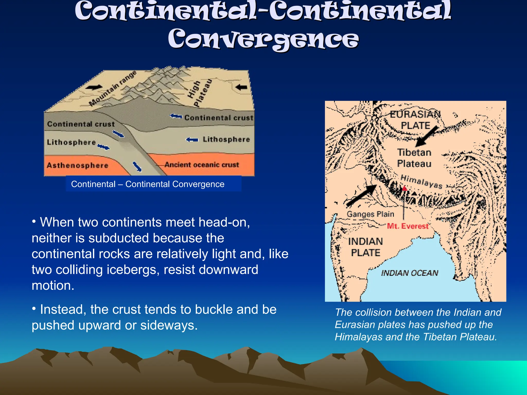
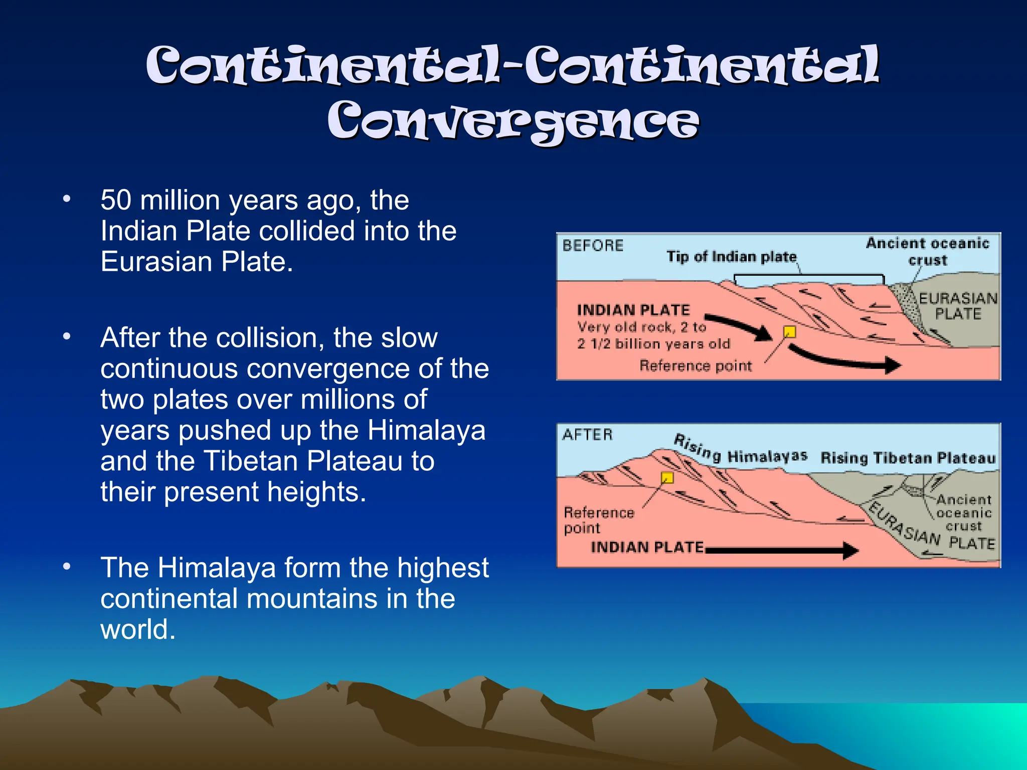
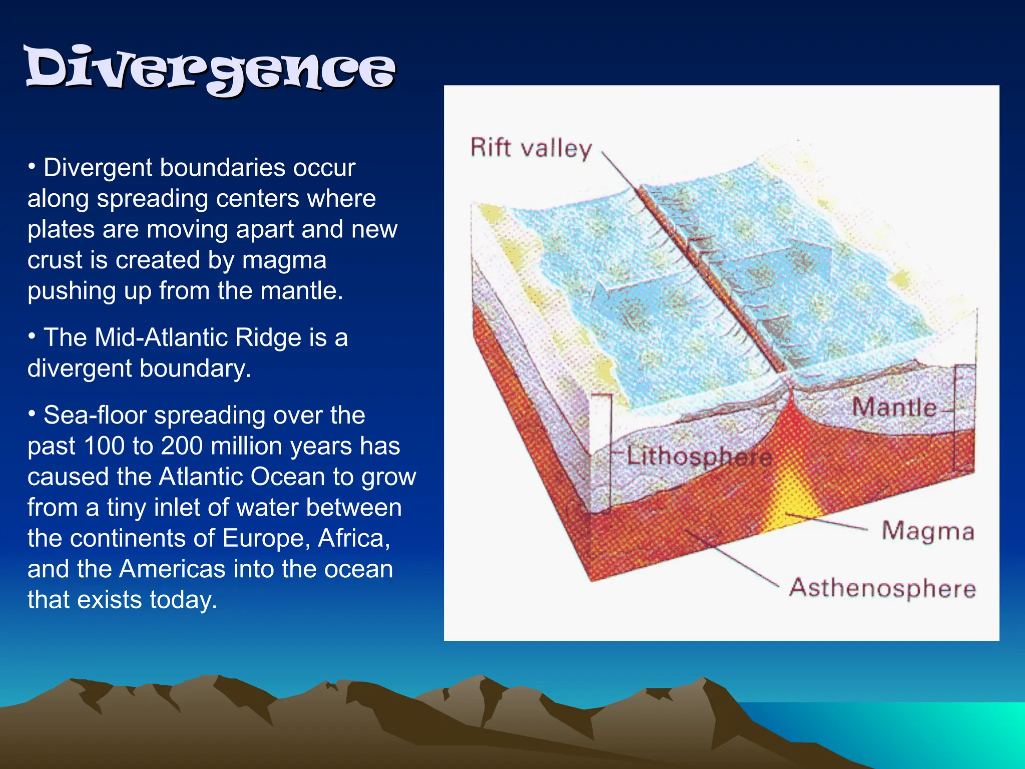
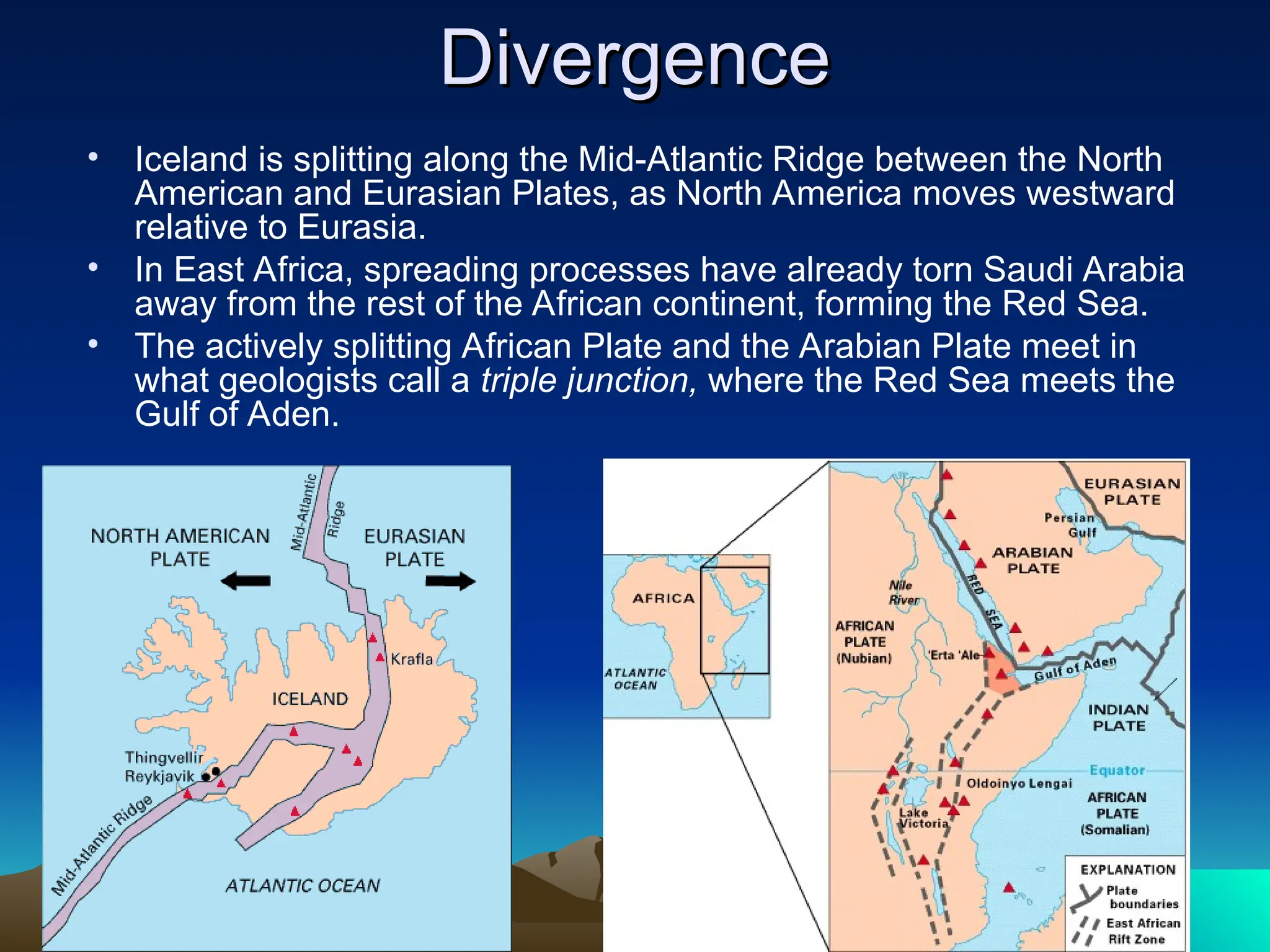
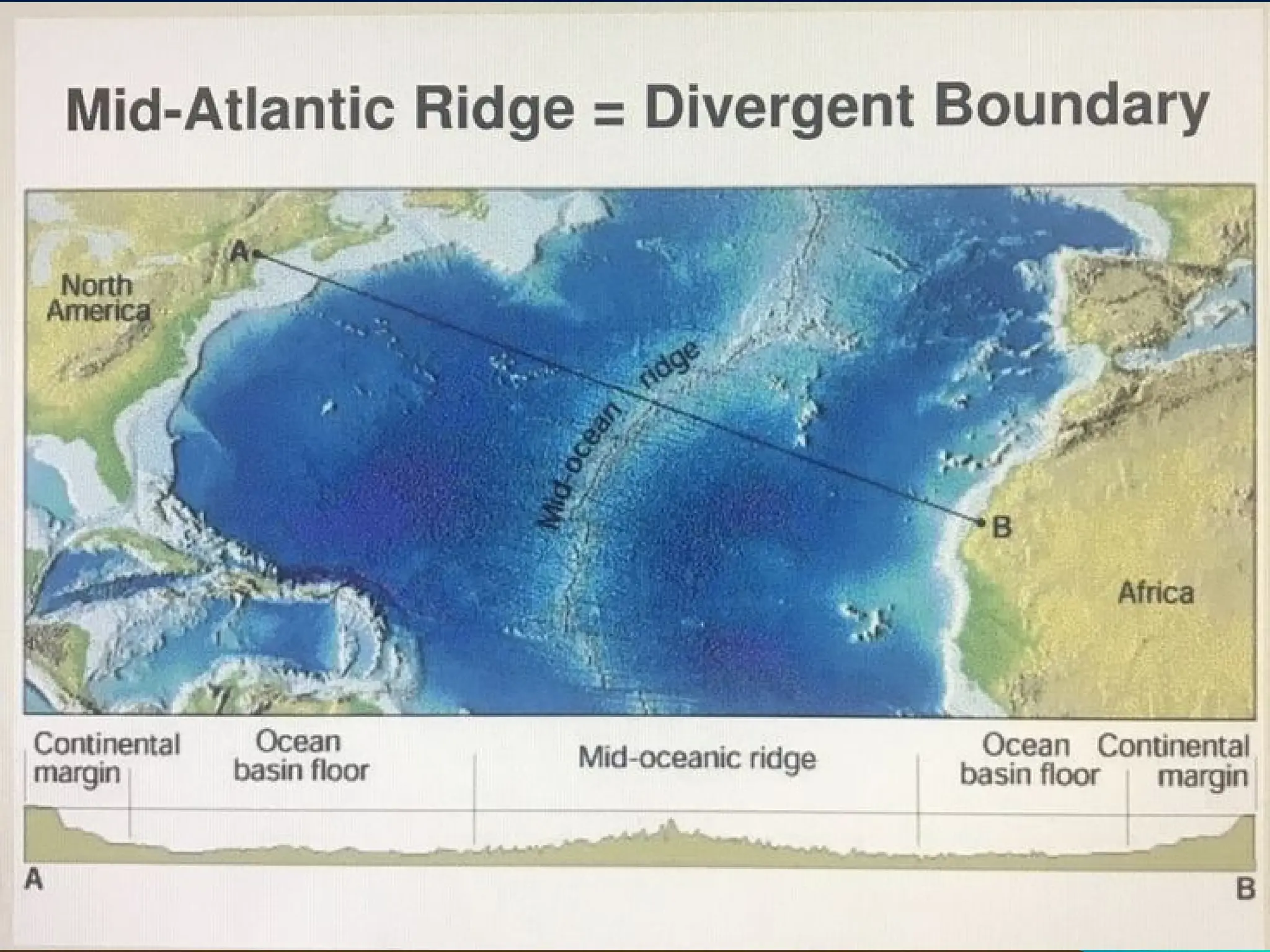
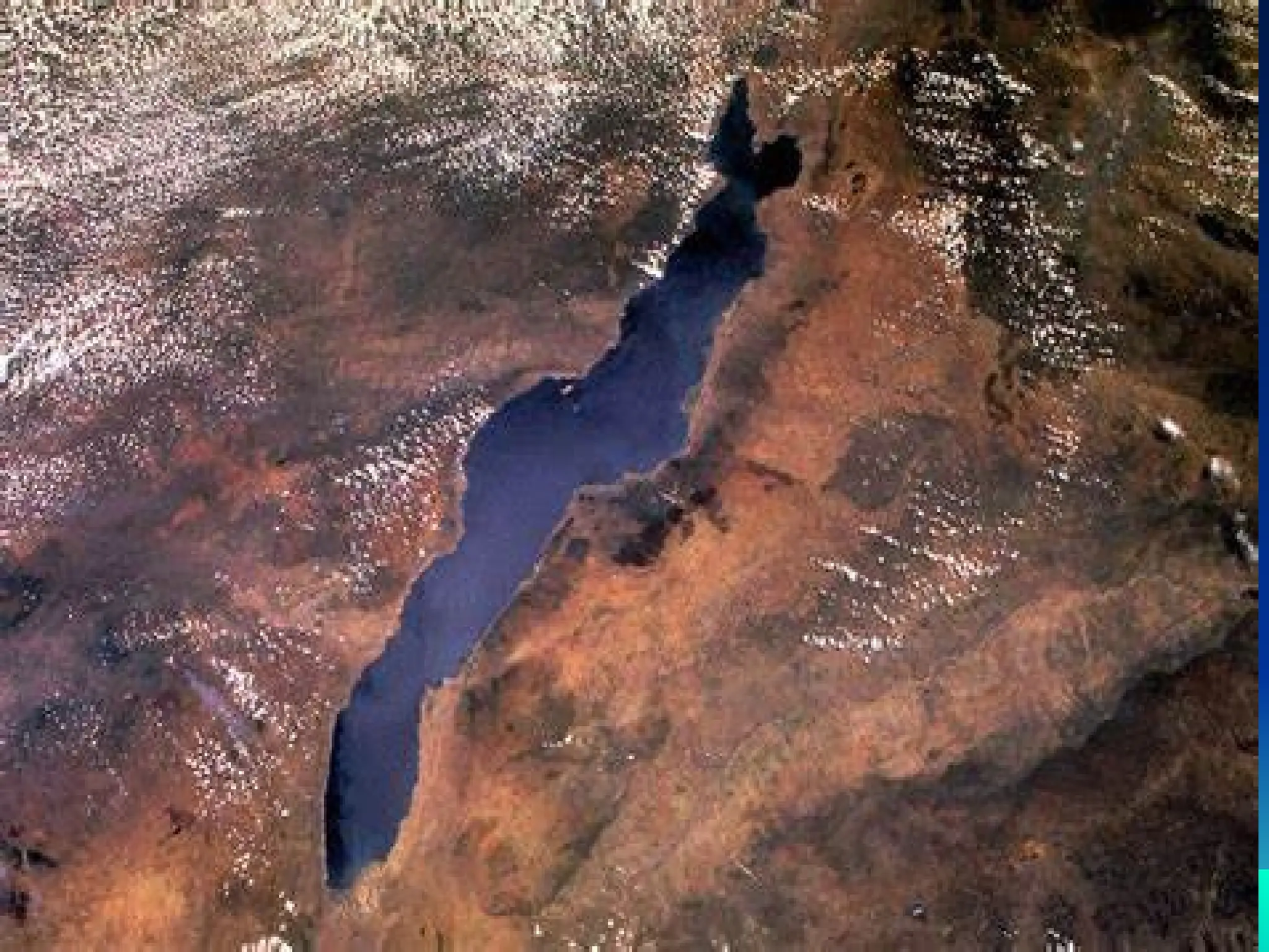
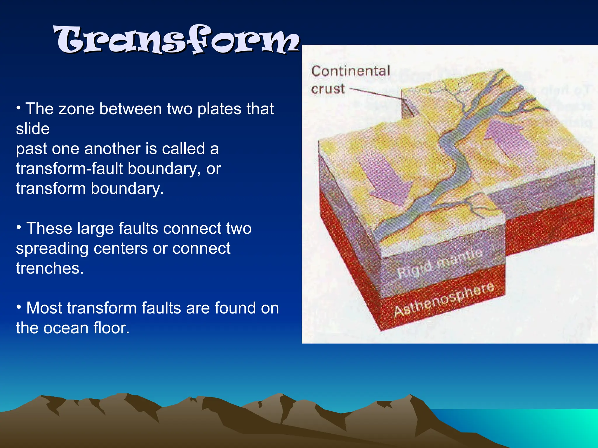
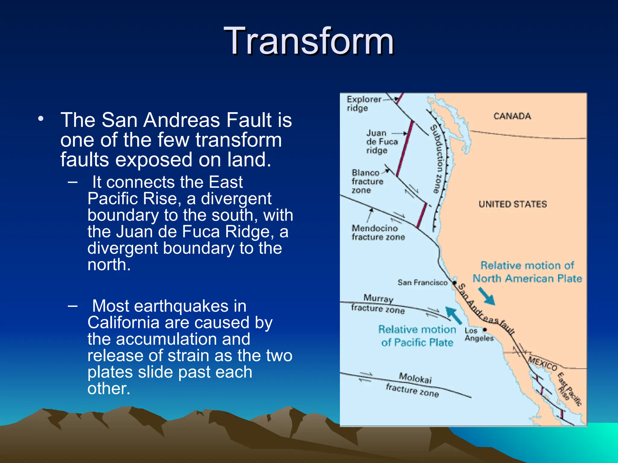
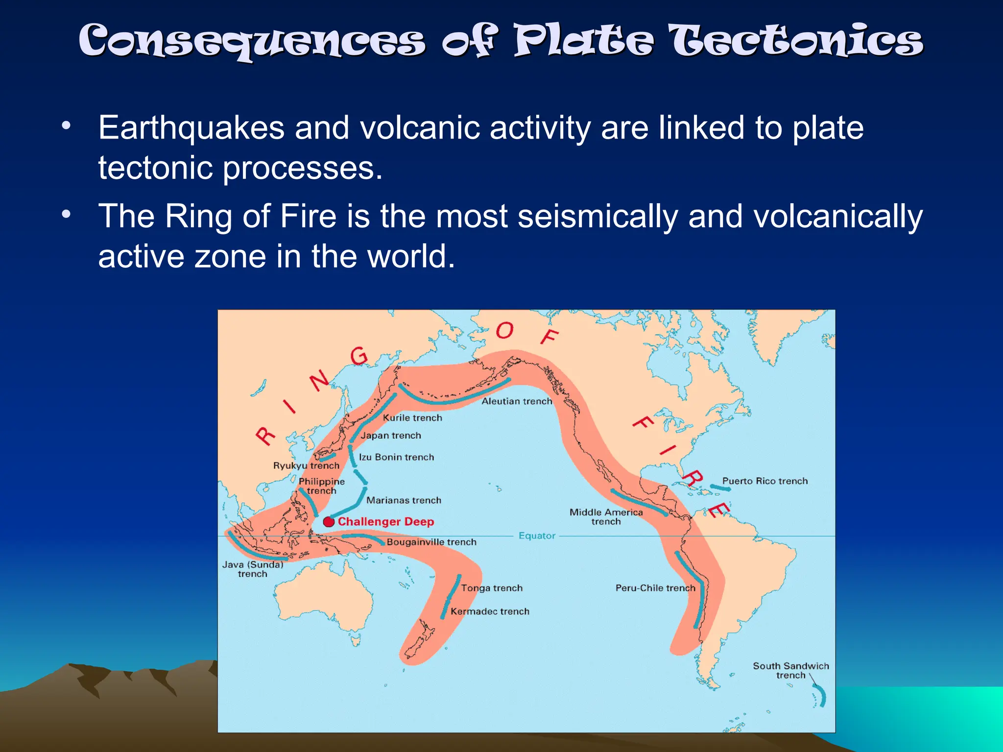
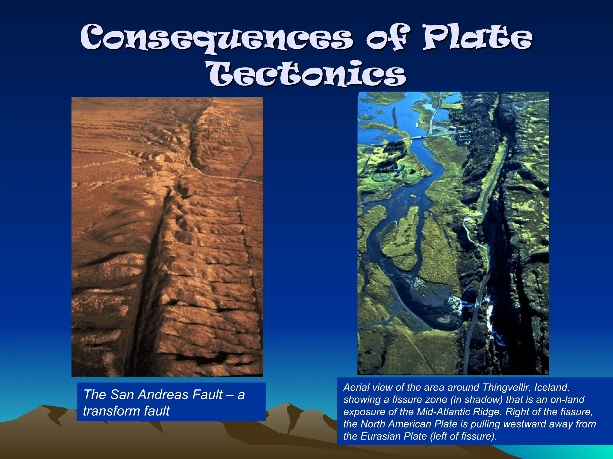
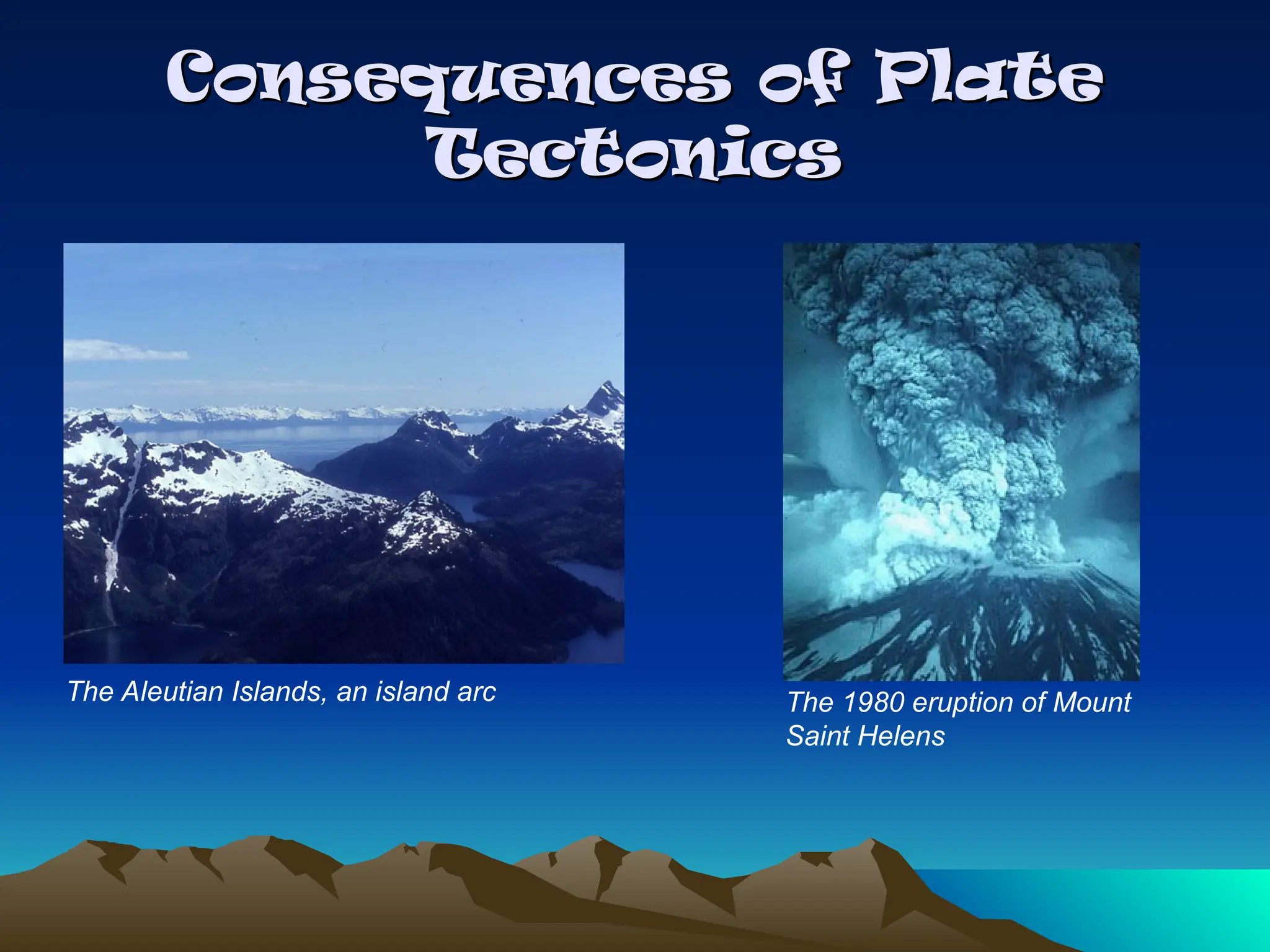
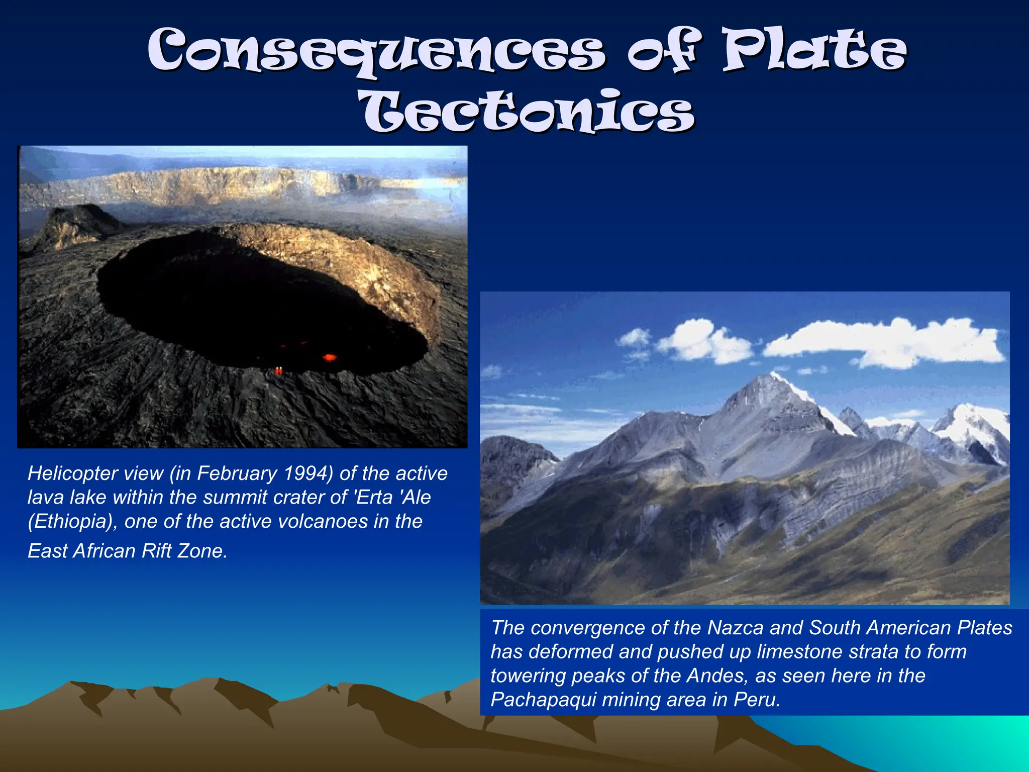
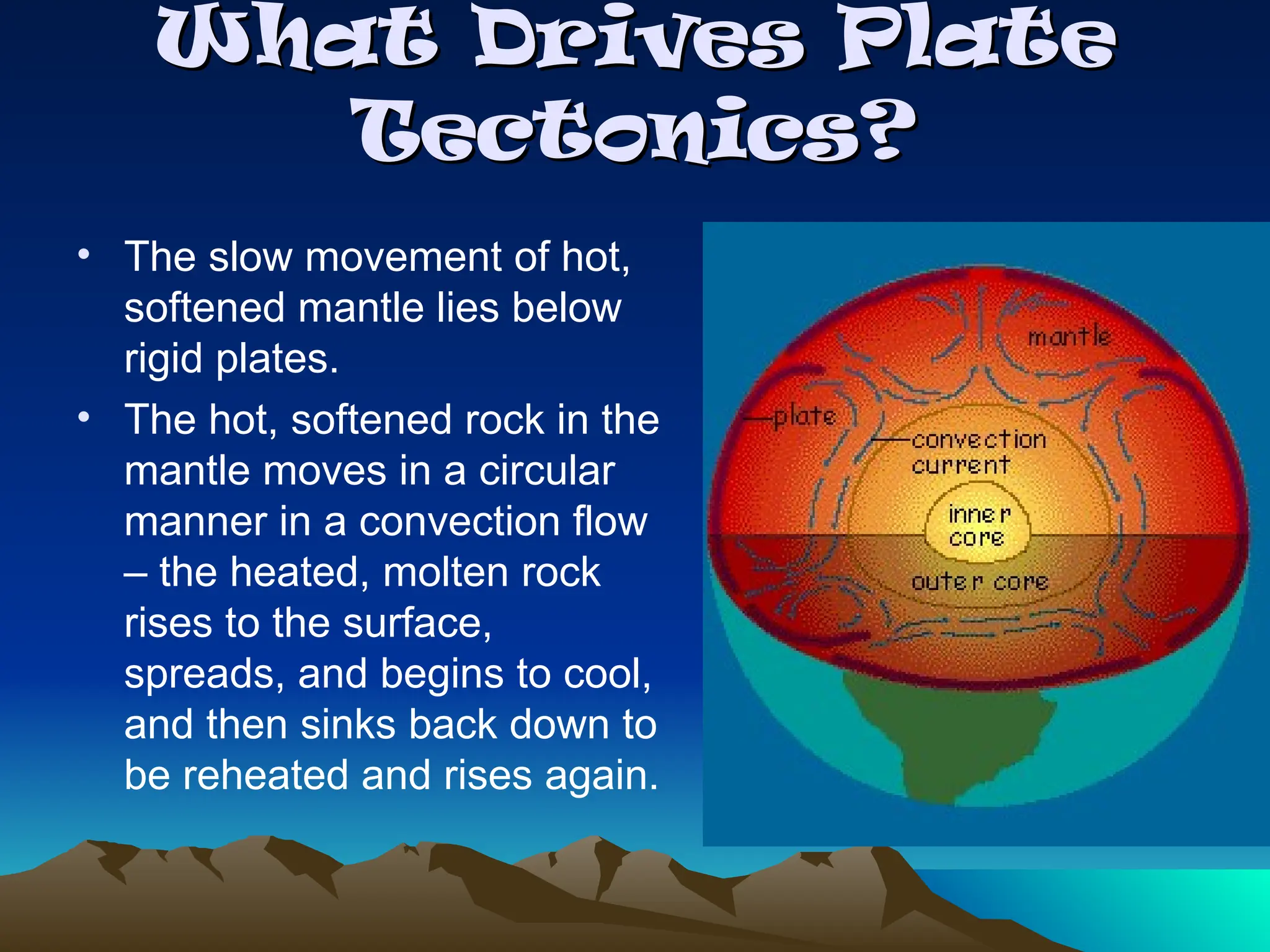
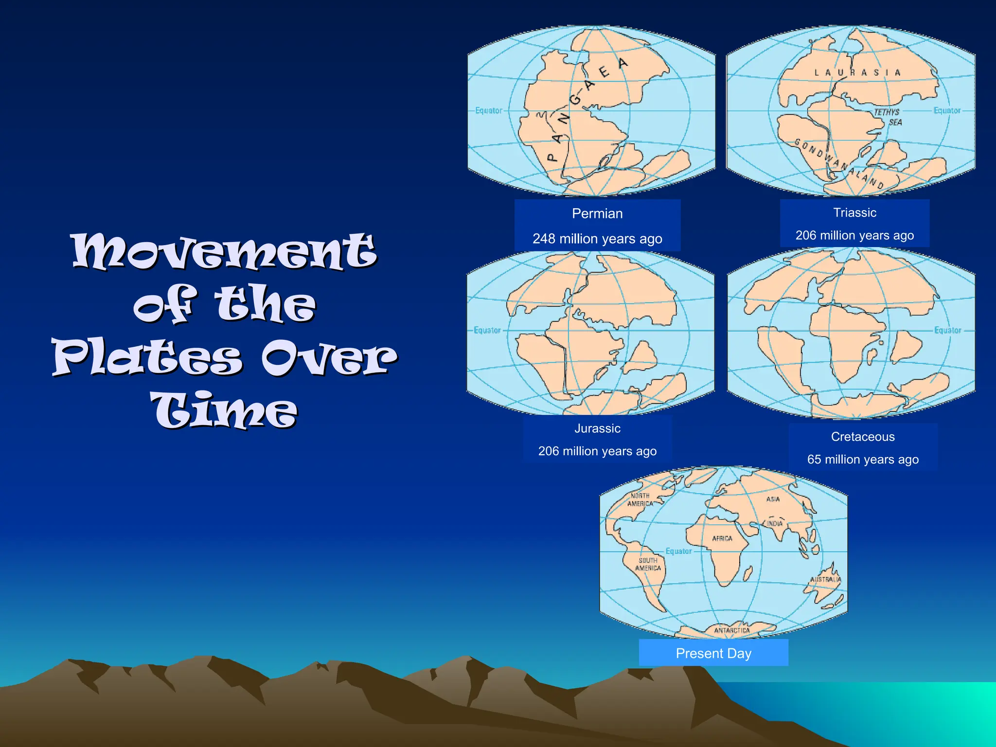
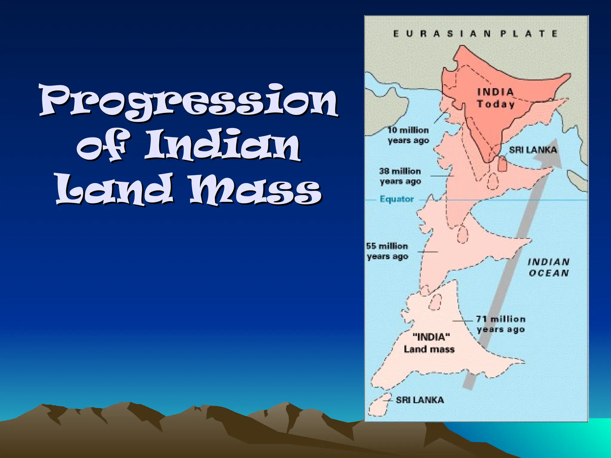
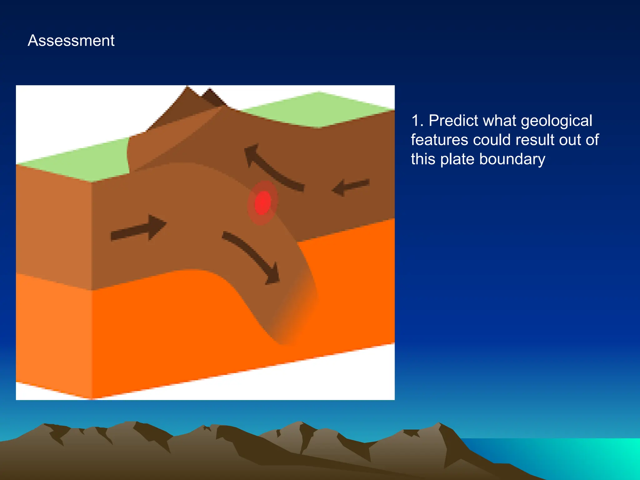
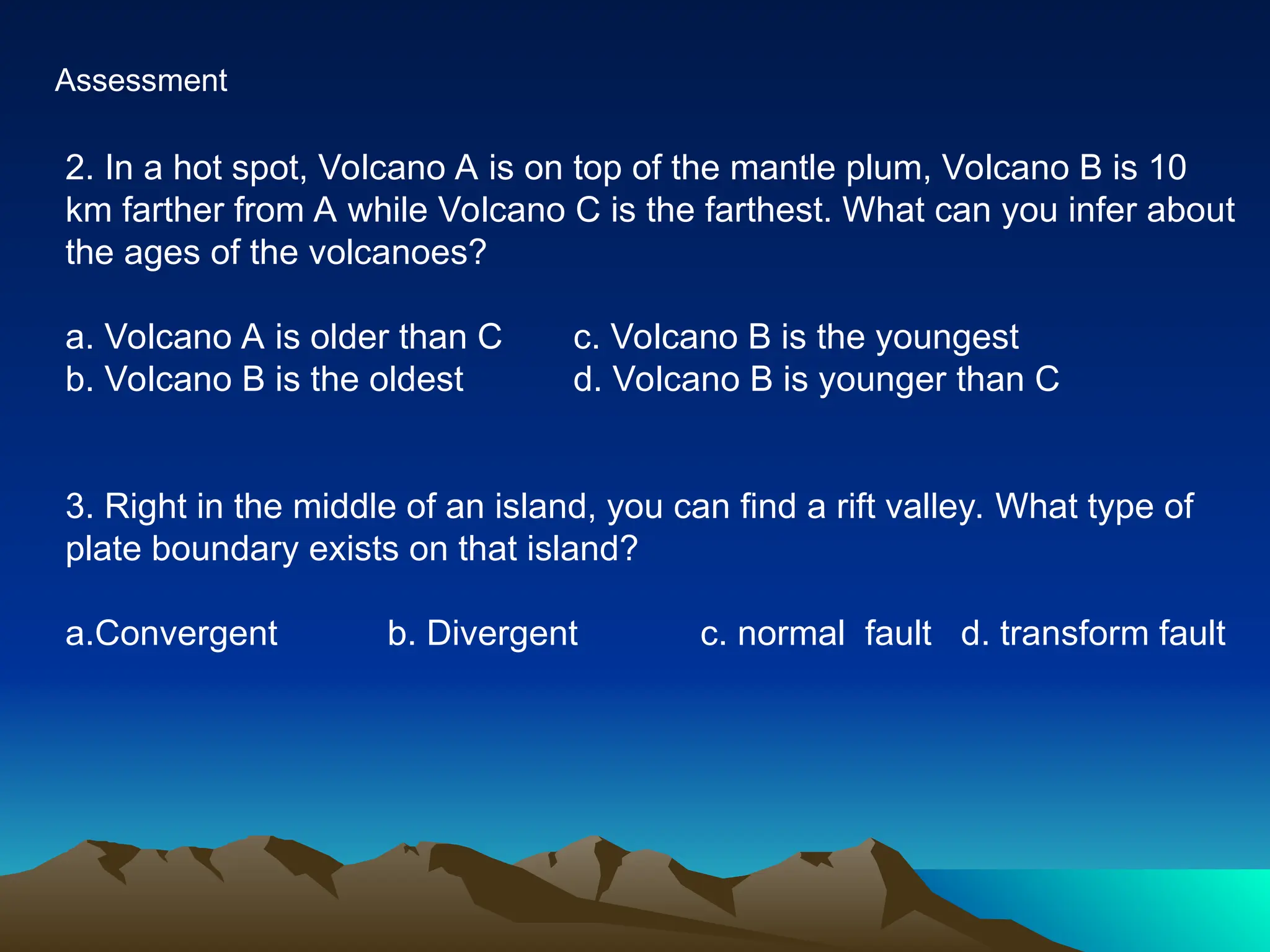
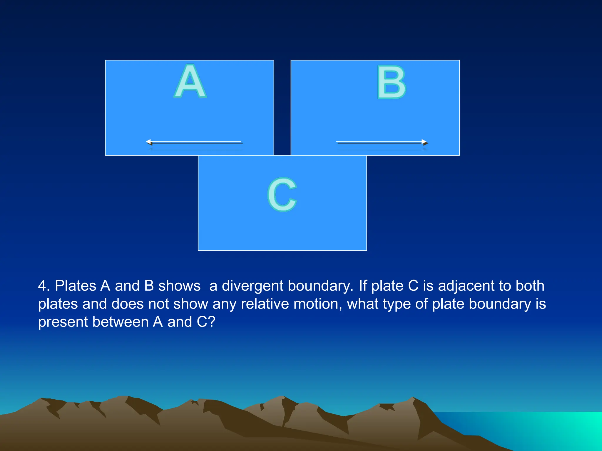
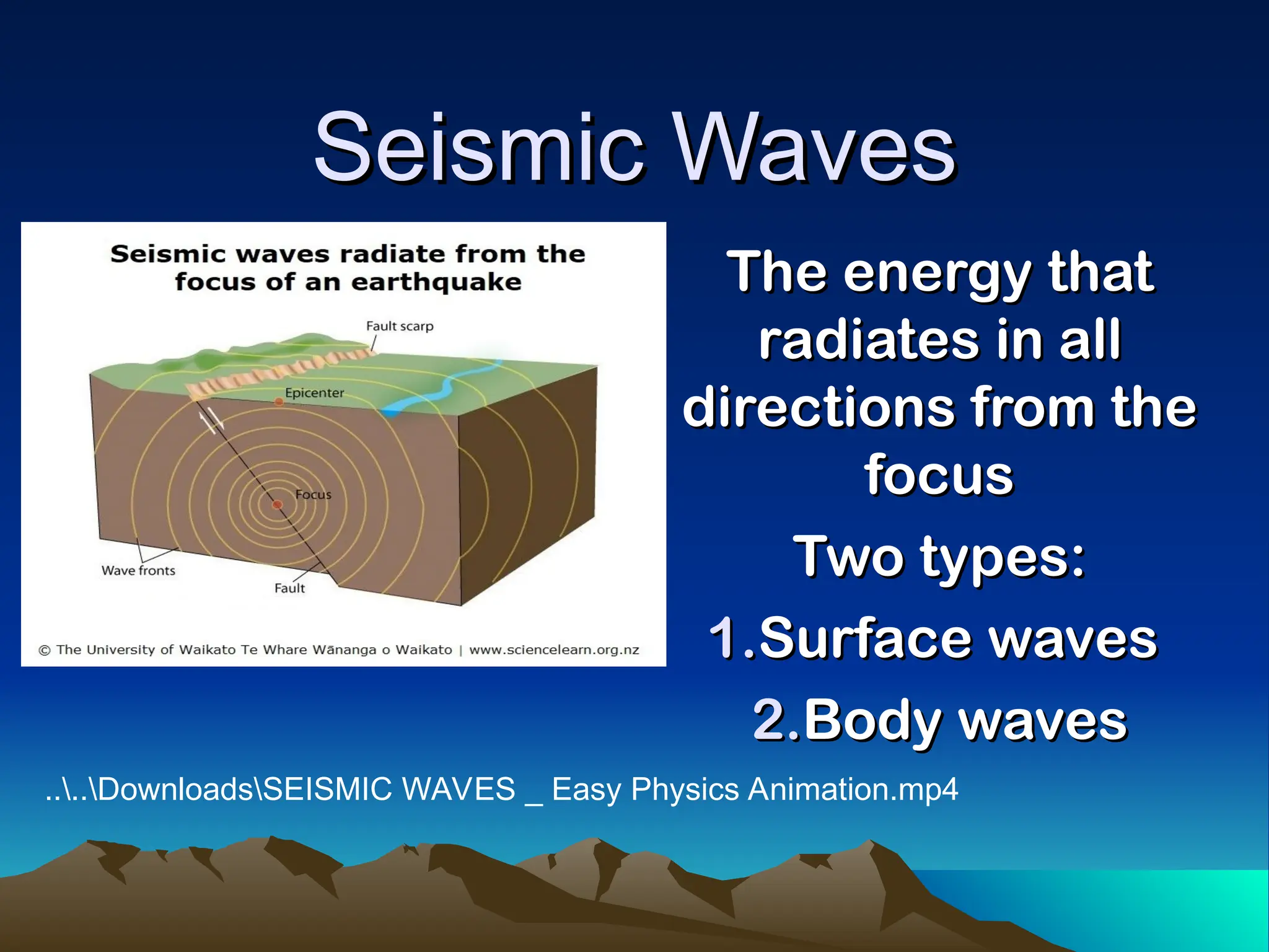
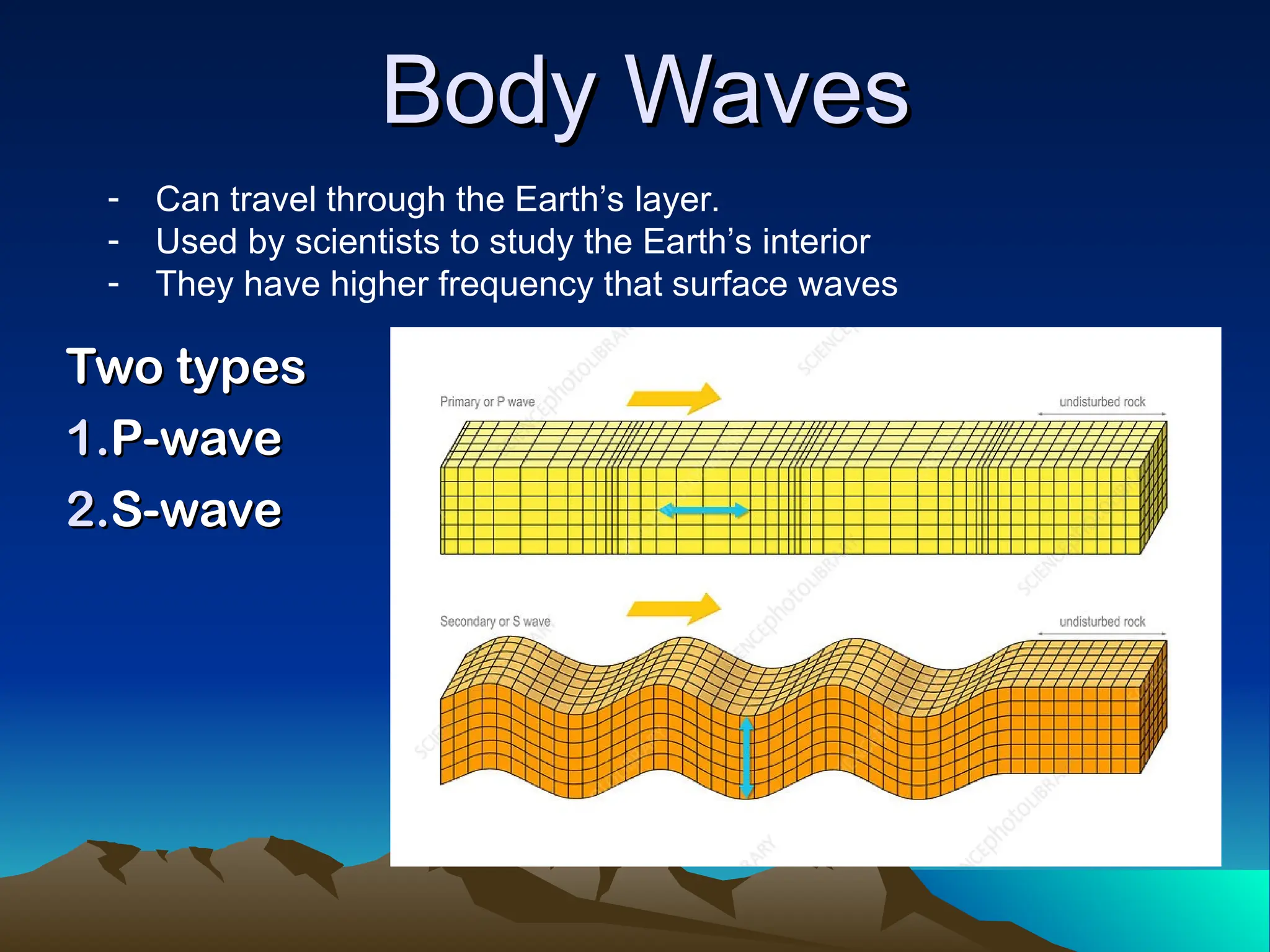
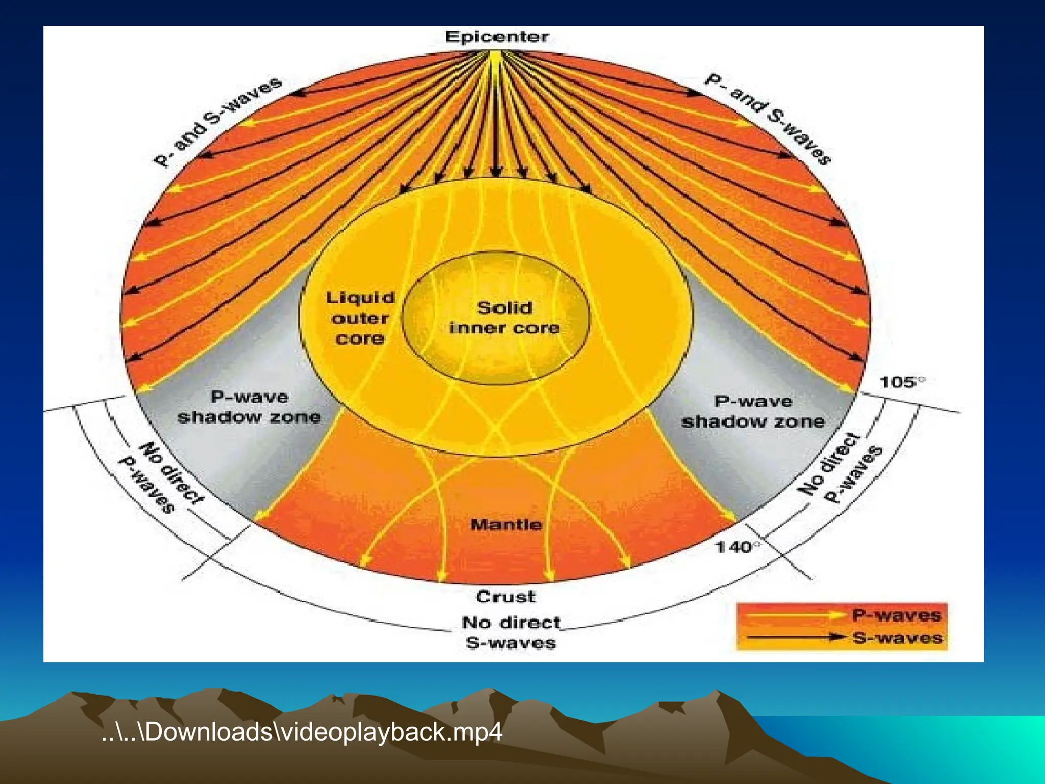
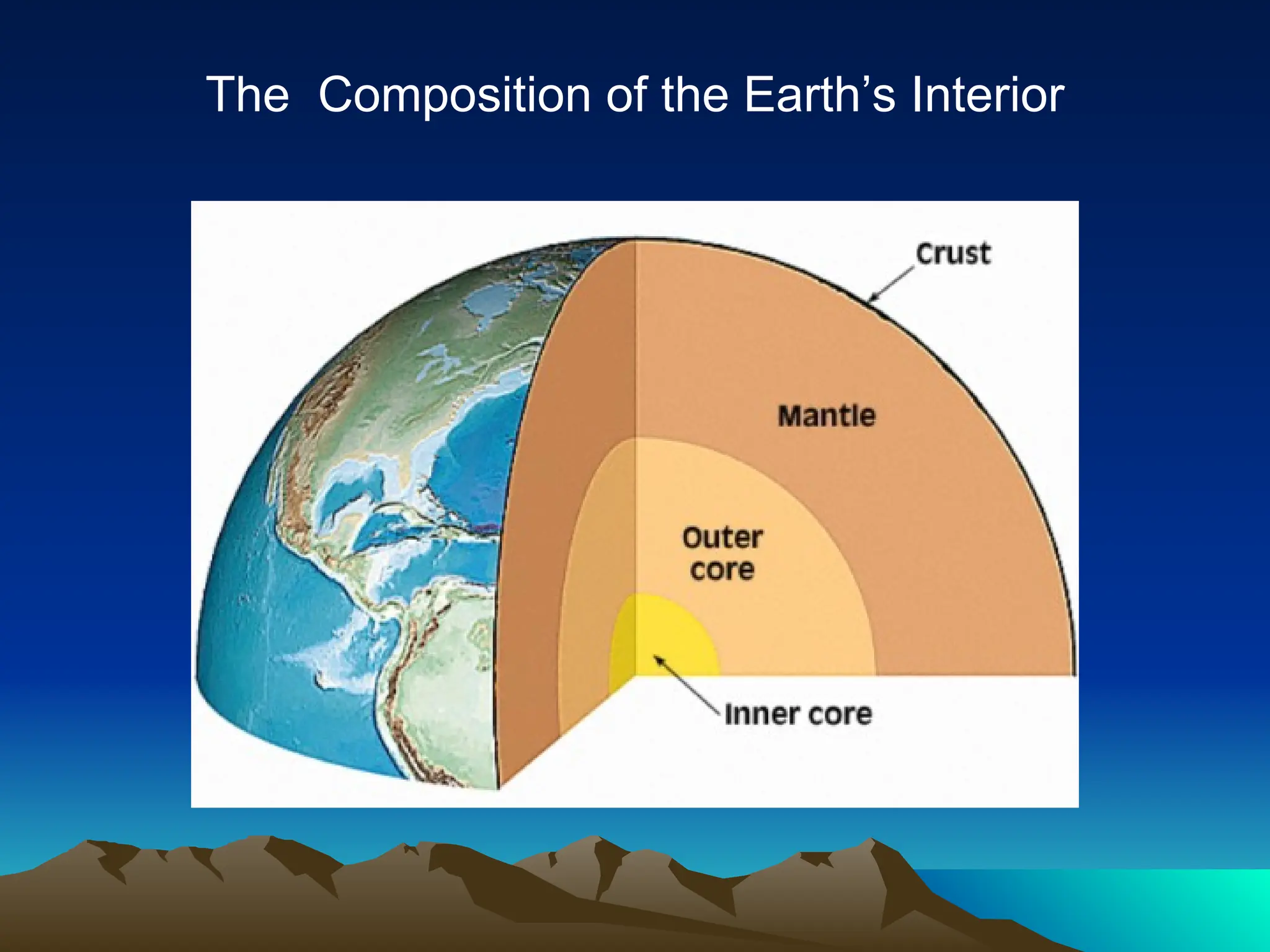
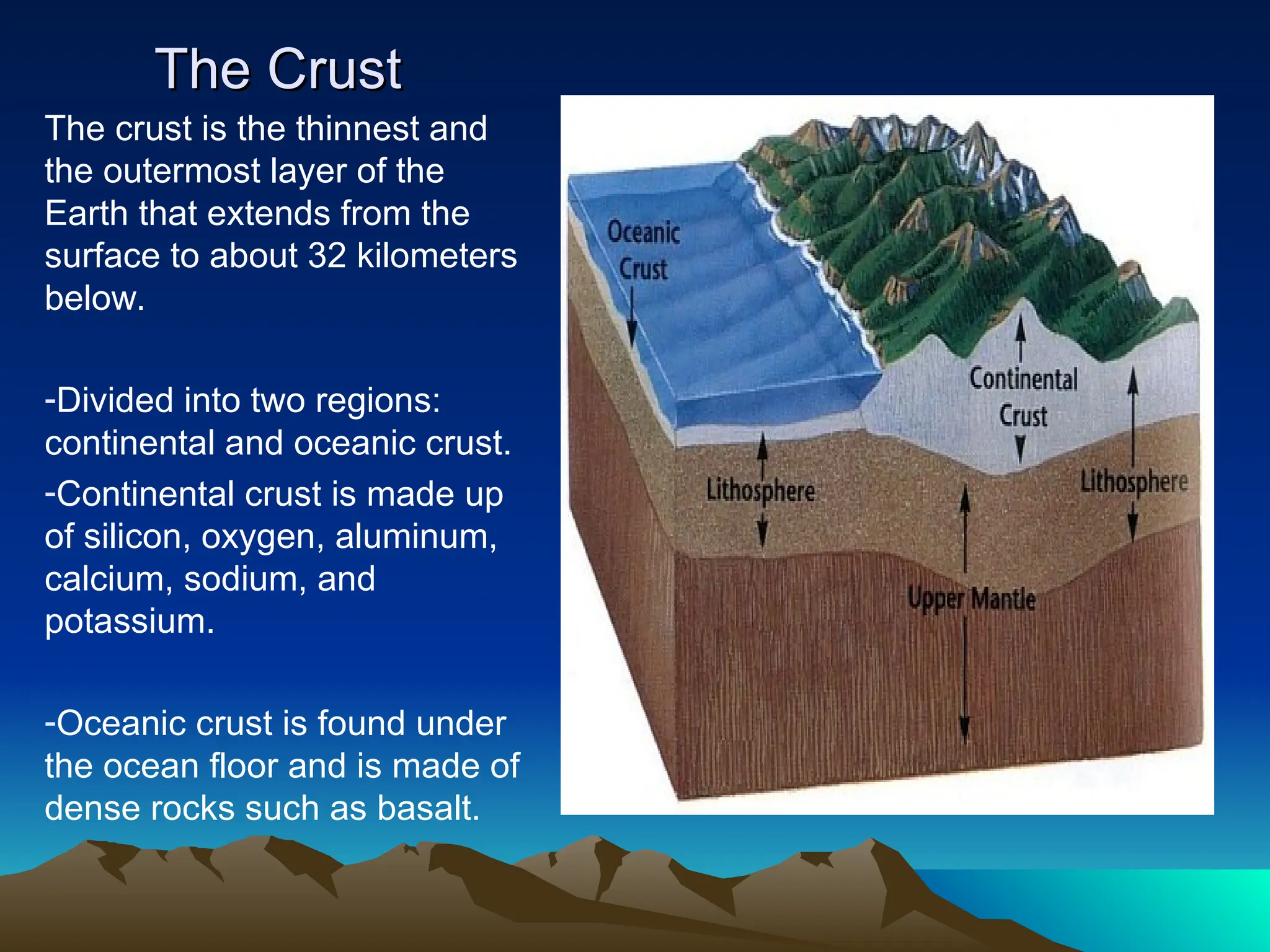
EARTH AND SPACE
EARTH AND SPACE
Our country is blessed with so many
land features such as mountains and
volcanoes. These features can be
sources of different minerals or can
be used for agricultural purposes.
For example, we have the majestic and
world renowned Mayon Volcano, because
of its activity, it produces fertile slopes and
plains which are used by the locals to grow
crops. Also, found in the northeastern coast
of Luzon, we have the Sierra Madre
mountain range which is home to many
endemic species of flora and fauna.
SIERRA MADRE
SIERRA MADRE
• Is the longest mountain range in the
Is the longest mountain range in the
Philippines, running from the northern
part of Luzon down to its southern end.
• It has unique ecological, cultural, and
It has unique ecological, cultural, and
geological significance.
Have you ever wounder
why our country is
why our country is
endowed with these kind
of geologic features?
We will study thoroughly the
framework that will enable us to
understand how and why several
features of the earth continuously
change. This is what we call
“
“PLATE TECTONICS”.
PLATE TECTONICS”.
Plate Tectonics
Plate Tectonics
The theory that the Earth’s outermost layer is
fragmented into a dozen or more large and
small plates that move relative to one another
as they ride on top of hotter, more mobile
material.
material.
What Are Tectonic Plates?
• A plate is a large, rigid slab of
solid rock.
– Plates are formed from the
lithosphere: the crust and the
upper part of the mantle.
• The plates “float” on the slowly
flowing asthenosphere: the
lower part of the mantle.
• The plates include both the
land and ocean floor.
• The Mohoriovicic discontinuity
or Moho is the boundary
between the crust and the
mantle.
Earth’s Plates
Earth’s Plates
Plate Boundaries
Plate Boundaries
Triangulation Method
A method used to locate the
epicenter of an earthquake.
It uses 3 recording stations.
If we have at least 3 recording
stations that can tell how far away
from them the earthquake occurred,
the epicenter can be determined
using the triangulation method. It
uses distance information from 3
seismic stations to locate the
epicenter of an earthquake.
The 3 circles will intersect
at one point that locates the
earthquake.
earthquake.
To compute the distance of the
epicenter from each of the stations
using the formula:
using the formula:
d = Td/ 8 seconds x 100 km
Where: d = distance
Where: d = distance
Td= time difference in the arrival
time of P and S wave (seconds)
Different Types of
Different Types of
Boundaries
Boundaries
Different Types of
Different Types of
Boundaries
Boundaries
• Convergent boundaries come together
– Places where crust is destroyed as one plate
dives under another
• Divergent boundaries spread apart
– Places where new crust is generated as the
plates pull away from each other
– New crust is created from magma pushing
up from the mantle
• Transform boundaries slide against
each other
– Places where crust is neither produced nor
destroyed as the plates slide horizontally
past each other
Oceanic-Continental Convergence
• The oceanic plate subducts under the continental plate because it has lower
density.
• The oceanic Nazca Plate is being subducted under the continental part of the
South American Plate.
• The South American Plate is being lifted up, creating the Andes mountains.
• Strong, destructive earthquakes and rapid uplift of mountain ranges are
common in this region.
• These earthquakes are often accompanied by uplift of the land by as much as
a few meters.
• Mount Saint Helens is along the subduction zone of the Juan de Fuca plate
(an oceanic plate) and the North American plate (a continental plate).
Oceanic – Continental Convergence
What will happen to the Oceanic Crust as it continues to move downward? Why?
What do you call the molten material?
What is formed on top of Continental crust?
As the plates continue to grind past each other, what geologic event could take
place?
Oceanic-Oceanic Convergence
• When two oceanic plates converge, one
is usually subducted under the other.
• An older oceanic plate is colder,
therefore more dense and less buoyant,
and will subduct under a younger,
hotter, less dense, and more buoyant
oceanic plate.
• In the process, a trench is formed.
– The deepest trenches in the oceans
are along oceanic-oceanic
subduction zones (i.e., the Marianas
Trench in the Pacific, which is
deeper than Mt. Everest is high).
• Subduction in oceanic-oceanic plate
convergence can result in the formation
of volcanoes.
• Examples of oceanic-oceanic
convergence are the arcuate chains of
islands in the southwest Pacific, Japan,
and the Aleutian Islands.
Oceanic – Oceanic Convergence
What are the geologic process/events that will occur because of this plate
movement?
What geologic features might form at the surface of plate B?
If the edge of Plate B suddenly flicks upward, a large amount of water may be
displaced. What could be formed at the surface of the sea?
Tsunami is the Japanese term for “harbor wave,” is a series of ocean
waves with very long wavelengths caused by large-scale disturbances of
ocean.
Tsunami is the Japanese term for “harbor wave,” is a series of ocean
waves with very long wavelengths caused by large-scale disturbances of
ocean.
Continental-Continental
Convergence
Convergence
Continental – Continental Convergence
• When two continents meet head-on,
neither is subducted because the
continental rocks are relatively light and, like
two colliding icebergs, resist downward
motion.
• Instead, the crust tends to buckle and be
pushed upward or sideways.
The collision between the Indian and
Eurasian plates has pushed up the
Himalayas and the Tibetan Plateau.
Continental-Continental
Convergence
Convergence
• 50 million years ago, the
Indian Plate collided into the
Eurasian Plate.
• After the collision, the slow
continuous convergence of the
two plates over millions of
years pushed up the Himalaya
and the Tibetan Plateau to
their present heights.
• The Himalaya form the highest
continental mountains in the
world.
Divergence
Divergence
• Divergent boundaries occur
along spreading centers where
plates are moving apart and new
crust is created by magma
pushing up from the mantle.
• The Mid-Atlantic Ridge is a
divergent boundary.
• Sea-floor spreading over the
past 100 to 200 million years has
caused the Atlantic Ocean to grow
from a tiny inlet of water between
the continents of Europe, Africa,
and the Americas into the ocean
that exists today.
Divergence
Divergence
• Iceland is splitting along the Mid-Atlantic Ridge between the North
American and Eurasian Plates, as North America moves westward
relative to Eurasia.
• In East Africa, spreading processes have already torn Saudi Arabia
away from the rest of the African continent, forming the Red Sea.
• The actively splitting African Plate and the Arabian Plate meet in
what geologists call a triple junction, where the Red Sea meets the
Gulf of Aden.
Transform
Transform
• The zone between two plates that
slide
past one another is called a
transform-fault boundary, or
transform boundary.
• These large faults connect two
spreading centers or connect
trenches.
• Most transform faults are found on
the ocean floor.
Transform
Transform
• The San Andreas Fault is
one of the few transform
faults exposed on land.
– It connects the East
Pacific Rise, a divergent
boundary to the south, with
the Juan de Fuca Ridge, a
divergent boundary to the
north.
– Most earthquakes in
California are caused by
the accumulation and
release of strain as the two
plates slide past each
other.
Consequences of Plate Tectonics
• Earthquakes and volcanic activity are linked to plate
tectonic processes.
• The Ring of Fire is the most seismically and volcanically
active zone in the world.
Consequences of Plate
Tectonics
Tectonics
The San Andreas Fault – a
transform fault
Aerial view of the area around Thingvellir, Iceland,
showing a fissure zone (in shadow) that is an on-land
exposure of the Mid-Atlantic Ridge. Right of the fissure,
the North American Plate is pulling westward away from
the Eurasian Plate (left of fissure).
Consequences of Plate
Tectonics
Tectonics
The Aleutian Islands, an island arc The 1980 eruption of Mount
Saint Helens
Consequences of Plate
Tectonics
Tectonics
The convergence of the Nazca and South American Plates
has deformed and pushed up limestone strata to form
towering peaks of the Andes, as seen here in the
Pachapaqui mining area in Peru.
Helicopter view (in February 1994) of the active
lava lake within the summit crater of 'Erta 'Ale
(Ethiopia), one of the active volcanoes in the
East African Rift Zone.
References
References
• Understanding Plate Motions. USGS.
http://pubs.usgs.gov/publications/text/unde
rstanding.html
• Plate Movement. OptIPuter Outreach.
http://education.sdsc.edu/optiputer/teacher
s/platemovement.html
• Plate Tectonics. The Way the Earth
Works. LHS GEMS, 2002.
What Drives Plate
What Drives Plate
Tectonics?
Tectonics?
• The slow movement of hot,
softened mantle lies below
rigid plates.
• The hot, softened rock in the
mantle moves in a circular
manner in a convection flow
– the heated, molten rock
rises to the surface,
spreads, and begins to cool,
and then sinks back down to
be reheated and rises again.
..CONVERGENT PLATE BOUNDARIES.mp4
....DownloadsExplanation of divergent plate boundaries and
shield volcano's.mp4
k
....DownloadsTransform Fault Boundaries_ Plates Sliding
Against Each Other.mp4
Movement
Movement
of the
of the
Plates Over
Plates Over
Time
Time
Permian
248 million years ago
Triassic
206 million years ago
Jurassic
206 million years ago
Cretaceous
65 million years ago
Present Day
Progression
Progression
of Indian
of Indian
Land Mass
Land Mass
Assessment
1. Predict what geological
features could result out of
this plate boundary
Assessment
2. In a hot spot, Volcano A is on top of the mantle plum, Volcano B is 10
km farther from A while Volcano C is the farthest. What can you infer about
the ages of the volcanoes?
a. Volcano A is older than C c. Volcano B is the youngest
b. Volcano B is the oldest d. Volcano B is younger than C
3. Right in the middle of an island, you can find a rift valley. What type of
plate boundary exists on that island?
a.Convergent b. Divergent c. normal fault d. transform fault
4. Plates A and B shows a divergent boundary. If plate C is adjacent to both
plates and does not show any relative motion, what type of plate boundary is
present between A and C?
Assessment
5. What geologic event is most likely to happen at the given type of plate
boundary in number 4?
a.Earthquake b. mountain formation c. rift valley d. volcanic eruption
6. You were ask to locate the epicenter of the earthquake. Which correct
sequence of events should you follow?
i.Determine the difference in the arrival of P and S waves recorded from each
seismological stations
ii.Use the triangulation method to locate the center
iii.Obtain the data from 3 different stations
iv.Determine the distance of the epicenter from the station.
a. i, iii, ii, iv b. iii, i, iv, ii c. iii, iv, i, ii d. iv, ii, i, iii
Assessment
7. What do you expect to find parallel to a trench?
a.Hot spot b. ocean ridge c. rift valley d. volcanic arc
A B C
8. Divergent a. Moving away from
each other
d. Earthquakes
9. Convergent b. Moving towards each
other
e. mountains,
volcanoes, trenches,
and earthquakes
10. Transform Fault c. Sliding past each
other
f. Rift valleys, oceanic
ridges, and earthquakes
1. An S-wave zone is formed as
seismic waves travels through
the Earth’s body. Which of the
following statements does this
S-wave shadow zone
indicate?
a. The inner core is liquid
b. The inner core is solid
c. The mantle is solid
d. The outer core is liquid
2. Why are there are no P-waves and S-waves received in the P-
wave shadow zone?
a.p-waves are absorbed and s-wave are refracted by Earth’s outer
core
b.p-waves are refracted and s-wave are absorbed by Earth’s outer
core
c.Both p-waves and s-waves are refracted by Earth’s outer core.
d.Both p-waves and s-waves are absorbed by Earth’s outer core.
3. What makes up the lithosphere?
a.Continental crust
b.Crust and the upper mantle
c.Oceanic crust and continental crust
d.Upper mantle
4. Miners dig into the Earth in search for precious rocks and minerals. In
which layer is the deepest explorations made by miners?
a.Crust c. mantle
b.Inner core d. outer core
5. How do you compare the densities of the Earth’s crust, mantle, and
core?
a.The mantle is less dense than the core but denser than the crust.
b.The mantle is less dense than both core and crust.
c.The mantle is denser than the core but less dense than the crust.
d.The mantle is denser than both the core and the crust.
6. The movement of the lithospheric plates is facilitated by a soft, weak,
and plastic-like layer. Which of the following layers is described in the
statement?
a.Asthenosphere c. lithosphere
b.Atmosphere d. mantle
7. Alfred Wegener is a German scientist who hypothesized that the Earth
was once made up of a single large landmass called Pangea. Which of
the following theories did Wegener propose?
a.Continental drift theory
b.Continental shift theory
c.Plate tectonics
d.Seafloor spreading theory
8. If you are a cartographer, what will give you an idea that the continents
were once joined?
a.Ocean depth b. position of south pole
b.Shape of the continents d. size of Atlantic ocean
9. Which observation was NOT instrumental in formulating the hypothesis of
seafloor spreading?
a.Depth of the ocean b. identifying location of glacial deposits
b.Magnetization of oceanic crustd. thickness of seafloor sediments
10. As a new seafloor is formed at the mid-ocean ridge, the old seafloor
farthest from the ridge is destroyed. Which of the stated processes
describes how the oceanic crust plunges into the earth and destroyed at the
mantle?
a.Convection b. construction
c. Diversion d. subduction
1.
1.What are the different layers
What are the different layers
of the Earth?
of the Earth?
2.
2.Why is there a need to study
Why is there a need to study
the Earth’s layers?
the Earth’s layers?
3.
3.What do the shape of the
What do the shape of the
continents tells us about their
past?
past?
STUDYING THE EARTH’S
INTERIOR
....DownloadsStructure Of The Earth _ The Dr. Binocs Show _
Educational Videos For Kids.mp4
Seismic Waves
Seismic Waves
The energy that
The energy that
radiates in all
radiates in all
directions from the
directions from the
focus
focus
Two types:
Two types:
1.
1.Surface waves
Surface waves
2.
2.Body waves
Body waves
....DownloadsSEISMIC WAVES _ Easy Physics Animation.mp4
Surface Waves
Surface Waves
Two types
Two types
1.
1.Love Waves
Love Waves
2.
2.Rayleigh
Rayleigh
Waves
Waves
-can only travel through the surface of the Earth. They arrive after the
main P and S waves and are confined to the outer layers of the
waves.
Love waves
Love waves
-is named after A.E.H. Love, a British mathematician who
worked out the mathematical model for this kind of wave in
911.
- It is faster that Rayleigh wave and it moves the ground in
a side-to-side horizontal motion, like a snake causing the
ground to twist. That is why Love waves cause the most
damage to structure during an earthquake.
....DownloadsPropagation of Seismic Waves_ Love waves.mp4
Rayleigh waves
Rayleigh waves
- Named after John William Strutt, Lord Rayleigh, who
mathematically predicted the existence of this kind of
wave in 1885.
- A Rayleigh wave rolls along the ground just like a wave
rolls across a lake or ocean. Since it rolls, it moves the
ground either up and down or side-to-side similar to the
direction of the wave’s movement.
- Most of the shaking felt from earthquake is due to
Rayleigh wave.
n....DownloadsPropagation of Seismic Waves_ Rayleigh waves.mp4
Body Waves
Body Waves
Two types
Two types
1.
1.P-wave
P-wave
2.
2.S-wave
S-wave
- Can travel through the Earth’s layer.
- Used by scientists to study the Earth’s interior
- They have higher frequency that surface waves
P-waves
P-waves
- P-wave (primary wave) is a pulse energy that travels
quickly through the Earth and through liquids.
- Travels faster than S-wave
- After an earthquake, it reaches the detector first.
- Also called compressional waves since they travel by
particles vibrating parallel to the direction of the wave
travel.
- They force the ground to move back and forward as
they are compressed and expanded.
- They travel through solids, liquids, and gases.
....DownloadsPropagation of Seismic Waves_ P-waves.mp4
S-waves
S-waves
- Secondary wave is a pulse of energy that travels slower
than a p-wave through Earth and solids.
- Moves as shear or transverse waves, force the ground
to sway from side to side, in rolling motion that shakes
the ground back and forth perpendicular to the direction
of the waves.
- The idea that s-wave cannot travel through any liquid
medium led seismologists to conclude that the outer
core is liquid.
....DownloadsPropagation of Seismic Waves_ S-waves.mp4
....Downloadsvideoplayback.mp4
The Composition of the Earth’s Interior
The Crust
The Crust
The crust is the thinnest and
the outermost layer of the
Earth that extends from the
surface to about 32 kilometers
below.
-Divided into two regions:
continental and oceanic crust.
-Continental crust is made up
of silicon, oxygen, aluminum,
calcium, sodium, and
potassium.
-Oceanic crust is found under
the ocean floor and is made of
dense rocks such as basalt.
plate-tectonics-power-point-1.ppt-agham.

plate-tectonics-power-point-1.ppt-agham.

  • 1.
    EARTH AND SPACE EARTHAND SPACE Our country is blessed with so many Our country is blessed with so many land features such as mountains and land features such as mountains and volcanoes. These features can be volcanoes. These features can be sources of different minerals or can sources of different minerals or can be used for agricultural purposes. be used for agricultural purposes.
  • 2.
    For example, wehave the majestic and For example, we have the majestic and world renowned Mayon Volcano, because world renowned Mayon Volcano, because of its activity, it produces fertile slopes and of its activity, it produces fertile slopes and plains which are used by the locals to grow plains which are used by the locals to grow crops. Also, found in the northeastern coast crops. Also, found in the northeastern coast of Luzon, we have the Sierra Madre of Luzon, we have the Sierra Madre mountain range which is home to many mountain range which is home to many endemic species of flora and fauna. endemic species of flora and fauna.
  • 3.
    SIERRA MADRE SIERRA MADRE •Is the longest mountain range in the Is the longest mountain range in the Philippines, running from the northern Philippines, running from the northern part of Luzon down to its southern end. part of Luzon down to its southern end. • It has unique ecological, cultural, and It has unique ecological, cultural, and geological significance. geological significance.
  • 4.
    Have you everwounder Have you ever wounder why our country is why our country is endowed with these kind endowed with these kind of geologic features? of geologic features?
  • 5.
    We will studythoroughly the We will study thoroughly the framework that will enable us to framework that will enable us to understand how and why several understand how and why several features of the earth continuously features of the earth continuously change. This is what we call change. This is what we call “ “PLATE TECTONICS”. PLATE TECTONICS”.
  • 6.
    Plate Tectonics Plate Tectonics Thetheory that the Earth’s outermost layer is The theory that the Earth’s outermost layer is fragmented into a dozen or more large and fragmented into a dozen or more large and small plates that move relative to one another small plates that move relative to one another as they ride on top of hotter, more mobile as they ride on top of hotter, more mobile material. material.
  • 7.
    What Are TectonicPlates? What Are Tectonic Plates? • A plate is a large, rigid slab of solid rock. – Plates are formed from the lithosphere: the crust and the upper part of the mantle. • The plates “float” on the slowly flowing asthenosphere: the lower part of the mantle. • The plates include both the land and ocean floor. • The Mohoriovicic discontinuity or Moho is the boundary between the crust and the mantle.
  • 8.
  • 9.
  • 10.
    Triangulation Method Triangulation Method Amethod used to locate the A method used to locate the epicenter of an earthquake. epicenter of an earthquake. It uses 3 recording stations. It uses 3 recording stations.
  • 11.
    If we haveat least 3 recording If we have at least 3 recording stations that can tell how far away stations that can tell how far away from them the earthquake occurred, from them the earthquake occurred, the epicenter can be determined the epicenter can be determined using the triangulation method. It using the triangulation method. It uses distance information from 3 uses distance information from 3 seismic stations to locate the seismic stations to locate the epicenter of an earthquake. epicenter of an earthquake.
  • 12.
    The 3 circleswill intersect The 3 circles will intersect at one point that locates the at one point that locates the earthquake. earthquake.
  • 13.
    To compute thedistance of the To compute the distance of the epicenter from each of the stations epicenter from each of the stations using the formula: using the formula: d = Td/ 8 seconds x 100 km d = Td/ 8 seconds x 100 km Where: d = distance Where: d = distance Td= time difference in the arrival Td= time difference in the arrival time of P and S wave (seconds) time of P and S wave (seconds)
  • 14.
    Different Types of DifferentTypes of Boundaries Boundaries
  • 15.
    Different Types of DifferentTypes of Boundaries Boundaries • Convergent boundaries come together – Places where crust is destroyed as one plate dives under another • Divergent boundaries spread apart – Places where new crust is generated as the plates pull away from each other – New crust is created from magma pushing up from the mantle • Transform boundaries slide against each other – Places where crust is neither produced nor destroyed as the plates slide horizontally past each other
  • 20.
    Oceanic-Continental Convergence Oceanic-Continental Convergence •The oceanic plate subducts under the continental plate because it has lower density. • The oceanic Nazca Plate is being subducted under the continental part of the South American Plate. • The South American Plate is being lifted up, creating the Andes mountains. • Strong, destructive earthquakes and rapid uplift of mountain ranges are common in this region. • These earthquakes are often accompanied by uplift of the land by as much as a few meters. • Mount Saint Helens is along the subduction zone of the Juan de Fuca plate (an oceanic plate) and the North American plate (a continental plate). Oceanic – Continental Convergence
  • 21.
    What will happento the Oceanic Crust as it continues to move downward? Why? What do you call the molten material? What is formed on top of Continental crust? As the plates continue to grind past each other, what geologic event could take place?
  • 22.
    Oceanic-Oceanic Convergence Oceanic-Oceanic Convergence •When two oceanic plates converge, one is usually subducted under the other. • An older oceanic plate is colder, therefore more dense and less buoyant, and will subduct under a younger, hotter, less dense, and more buoyant oceanic plate. • In the process, a trench is formed. – The deepest trenches in the oceans are along oceanic-oceanic subduction zones (i.e., the Marianas Trench in the Pacific, which is deeper than Mt. Everest is high). • Subduction in oceanic-oceanic plate convergence can result in the formation of volcanoes. • Examples of oceanic-oceanic convergence are the arcuate chains of islands in the southwest Pacific, Japan, and the Aleutian Islands. Oceanic – Oceanic Convergence
  • 23.
    What are thegeologic process/events that will occur because of this plate movement? What geologic features might form at the surface of plate B? If the edge of Plate B suddenly flicks upward, a large amount of water may be displaced. What could be formed at the surface of the sea?
  • 24.
    Tsunami is theJapanese term for “harbor wave,” is a series of ocean waves with very long wavelengths caused by large-scale disturbances of ocean.
  • 25.
    Tsunami is theJapanese term for “harbor wave,” is a series of ocean waves with very long wavelengths caused by large-scale disturbances of ocean.
  • 26.
    Continental-Continental Continental-Continental Convergence Convergence Continental – ContinentalConvergence • When two continents meet head-on, neither is subducted because the continental rocks are relatively light and, like two colliding icebergs, resist downward motion. • Instead, the crust tends to buckle and be pushed upward or sideways. The collision between the Indian and Eurasian plates has pushed up the Himalayas and the Tibetan Plateau.
  • 27.
    Continental-Continental Continental-Continental Convergence Convergence • 50 millionyears ago, the Indian Plate collided into the Eurasian Plate. • After the collision, the slow continuous convergence of the two plates over millions of years pushed up the Himalaya and the Tibetan Plateau to their present heights. • The Himalaya form the highest continental mountains in the world.
  • 28.
    Divergence Divergence • Divergent boundariesoccur along spreading centers where plates are moving apart and new crust is created by magma pushing up from the mantle. • The Mid-Atlantic Ridge is a divergent boundary. • Sea-floor spreading over the past 100 to 200 million years has caused the Atlantic Ocean to grow from a tiny inlet of water between the continents of Europe, Africa, and the Americas into the ocean that exists today.
  • 29.
    Divergence Divergence • Iceland issplitting along the Mid-Atlantic Ridge between the North American and Eurasian Plates, as North America moves westward relative to Eurasia. • In East Africa, spreading processes have already torn Saudi Arabia away from the rest of the African continent, forming the Red Sea. • The actively splitting African Plate and the Arabian Plate meet in what geologists call a triple junction, where the Red Sea meets the Gulf of Aden.
  • 32.
    Transform Transform • The zonebetween two plates that slide past one another is called a transform-fault boundary, or transform boundary. • These large faults connect two spreading centers or connect trenches. • Most transform faults are found on the ocean floor.
  • 33.
    Transform Transform • The SanAndreas Fault is one of the few transform faults exposed on land. – It connects the East Pacific Rise, a divergent boundary to the south, with the Juan de Fuca Ridge, a divergent boundary to the north. – Most earthquakes in California are caused by the accumulation and release of strain as the two plates slide past each other.
  • 34.
    Consequences of PlateTectonics Consequences of Plate Tectonics • Earthquakes and volcanic activity are linked to plate tectonic processes. • The Ring of Fire is the most seismically and volcanically active zone in the world.
  • 35.
    Consequences of Plate Consequencesof Plate Tectonics Tectonics The San Andreas Fault – a transform fault Aerial view of the area around Thingvellir, Iceland, showing a fissure zone (in shadow) that is an on-land exposure of the Mid-Atlantic Ridge. Right of the fissure, the North American Plate is pulling westward away from the Eurasian Plate (left of fissure).
  • 36.
    Consequences of Plate Consequencesof Plate Tectonics Tectonics The Aleutian Islands, an island arc The 1980 eruption of Mount Saint Helens
  • 37.
    Consequences of Plate Consequencesof Plate Tectonics Tectonics The convergence of the Nazca and South American Plates has deformed and pushed up limestone strata to form towering peaks of the Andes, as seen here in the Pachapaqui mining area in Peru. Helicopter view (in February 1994) of the active lava lake within the summit crater of 'Erta 'Ale (Ethiopia), one of the active volcanoes in the East African Rift Zone.
  • 38.
    References References • Understanding PlateMotions. USGS. http://pubs.usgs.gov/publications/text/unde rstanding.html • Plate Movement. OptIPuter Outreach. http://education.sdsc.edu/optiputer/teacher s/platemovement.html • Plate Tectonics. The Way the Earth Works. LHS GEMS, 2002.
  • 39.
    What Drives Plate WhatDrives Plate Tectonics? Tectonics? • The slow movement of hot, softened mantle lies below rigid plates. • The hot, softened rock in the mantle moves in a circular manner in a convection flow – the heated, molten rock rises to the surface, spreads, and begins to cool, and then sinks back down to be reheated and rises again.
  • 40.
    ..CONVERGENT PLATE BOUNDARIES.mp4 ....DownloadsExplanationof divergent plate boundaries and shield volcano's.mp4 k ....DownloadsTransform Fault Boundaries_ Plates Sliding Against Each Other.mp4
  • 41.
    Movement Movement of the of the PlatesOver Plates Over Time Time Permian 248 million years ago Triassic 206 million years ago Jurassic 206 million years ago Cretaceous 65 million years ago Present Day
  • 42.
  • 43.
    Assessment 1. Predict whatgeological features could result out of this plate boundary
  • 44.
    Assessment 2. In ahot spot, Volcano A is on top of the mantle plum, Volcano B is 10 km farther from A while Volcano C is the farthest. What can you infer about the ages of the volcanoes? a. Volcano A is older than C c. Volcano B is the youngest b. Volcano B is the oldest d. Volcano B is younger than C 3. Right in the middle of an island, you can find a rift valley. What type of plate boundary exists on that island? a.Convergent b. Divergent c. normal fault d. transform fault
  • 45.
    4. Plates Aand B shows a divergent boundary. If plate C is adjacent to both plates and does not show any relative motion, what type of plate boundary is present between A and C?
  • 46.
    Assessment 5. What geologicevent is most likely to happen at the given type of plate boundary in number 4? a.Earthquake b. mountain formation c. rift valley d. volcanic eruption 6. You were ask to locate the epicenter of the earthquake. Which correct sequence of events should you follow? i.Determine the difference in the arrival of P and S waves recorded from each seismological stations ii.Use the triangulation method to locate the center iii.Obtain the data from 3 different stations iv.Determine the distance of the epicenter from the station. a. i, iii, ii, iv b. iii, i, iv, ii c. iii, iv, i, ii d. iv, ii, i, iii
  • 47.
    Assessment 7. What doyou expect to find parallel to a trench? a.Hot spot b. ocean ridge c. rift valley d. volcanic arc A B C 8. Divergent a. Moving away from each other d. Earthquakes 9. Convergent b. Moving towards each other e. mountains, volcanoes, trenches, and earthquakes 10. Transform Fault c. Sliding past each other f. Rift valleys, oceanic ridges, and earthquakes
  • 48.
    1. An S-wavezone is formed as seismic waves travels through the Earth’s body. Which of the following statements does this S-wave shadow zone indicate? a. The inner core is liquid b. The inner core is solid c. The mantle is solid d. The outer core is liquid
  • 49.
    2. Why arethere are no P-waves and S-waves received in the P- wave shadow zone? a.p-waves are absorbed and s-wave are refracted by Earth’s outer core b.p-waves are refracted and s-wave are absorbed by Earth’s outer core c.Both p-waves and s-waves are refracted by Earth’s outer core. d.Both p-waves and s-waves are absorbed by Earth’s outer core. 3. What makes up the lithosphere? a.Continental crust b.Crust and the upper mantle c.Oceanic crust and continental crust d.Upper mantle
  • 50.
    4. Miners diginto the Earth in search for precious rocks and minerals. In which layer is the deepest explorations made by miners? a.Crust c. mantle b.Inner core d. outer core 5. How do you compare the densities of the Earth’s crust, mantle, and core? a.The mantle is less dense than the core but denser than the crust. b.The mantle is less dense than both core and crust. c.The mantle is denser than the core but less dense than the crust. d.The mantle is denser than both the core and the crust.
  • 51.
    6. The movementof the lithospheric plates is facilitated by a soft, weak, and plastic-like layer. Which of the following layers is described in the statement? a.Asthenosphere c. lithosphere b.Atmosphere d. mantle 7. Alfred Wegener is a German scientist who hypothesized that the Earth was once made up of a single large landmass called Pangea. Which of the following theories did Wegener propose? a.Continental drift theory b.Continental shift theory c.Plate tectonics d.Seafloor spreading theory
  • 52.
    8. If youare a cartographer, what will give you an idea that the continents were once joined? a.Ocean depth b. position of south pole b.Shape of the continents d. size of Atlantic ocean 9. Which observation was NOT instrumental in formulating the hypothesis of seafloor spreading? a.Depth of the ocean b. identifying location of glacial deposits b.Magnetization of oceanic crustd. thickness of seafloor sediments 10. As a new seafloor is formed at the mid-ocean ridge, the old seafloor farthest from the ridge is destroyed. Which of the stated processes describes how the oceanic crust plunges into the earth and destroyed at the mantle? a.Convection b. construction c. Diversion d. subduction
  • 53.
    1. 1.What are thedifferent layers What are the different layers of the Earth? of the Earth? 2. 2.Why is there a need to study Why is there a need to study the Earth’s layers? the Earth’s layers? 3. 3.What do the shape of the What do the shape of the continents tells us about their continents tells us about their past? past?
  • 54.
    STUDYING THE EARTH’S INTERIOR ....DownloadsStructureOf The Earth _ The Dr. Binocs Show _ Educational Videos For Kids.mp4
  • 55.
    Seismic Waves Seismic Waves Theenergy that The energy that radiates in all radiates in all directions from the directions from the focus focus Two types: Two types: 1. 1.Surface waves Surface waves 2. 2.Body waves Body waves ....DownloadsSEISMIC WAVES _ Easy Physics Animation.mp4
  • 56.
    Surface Waves Surface Waves Twotypes Two types 1. 1.Love Waves Love Waves 2. 2.Rayleigh Rayleigh Waves Waves -can only travel through the surface of the Earth. They arrive after the main P and S waves and are confined to the outer layers of the waves.
  • 57.
    Love waves Love waves -isnamed after A.E.H. Love, a British mathematician who worked out the mathematical model for this kind of wave in 911. - It is faster that Rayleigh wave and it moves the ground in a side-to-side horizontal motion, like a snake causing the ground to twist. That is why Love waves cause the most damage to structure during an earthquake. ....DownloadsPropagation of Seismic Waves_ Love waves.mp4
  • 58.
    Rayleigh waves Rayleigh waves -Named after John William Strutt, Lord Rayleigh, who mathematically predicted the existence of this kind of wave in 1885. - A Rayleigh wave rolls along the ground just like a wave rolls across a lake or ocean. Since it rolls, it moves the ground either up and down or side-to-side similar to the direction of the wave’s movement. - Most of the shaking felt from earthquake is due to Rayleigh wave. n....DownloadsPropagation of Seismic Waves_ Rayleigh waves.mp4
  • 59.
    Body Waves Body Waves Twotypes Two types 1. 1.P-wave P-wave 2. 2.S-wave S-wave - Can travel through the Earth’s layer. - Used by scientists to study the Earth’s interior - They have higher frequency that surface waves
  • 60.
    P-waves P-waves - P-wave (primarywave) is a pulse energy that travels quickly through the Earth and through liquids. - Travels faster than S-wave - After an earthquake, it reaches the detector first. - Also called compressional waves since they travel by particles vibrating parallel to the direction of the wave travel. - They force the ground to move back and forward as they are compressed and expanded. - They travel through solids, liquids, and gases. ....DownloadsPropagation of Seismic Waves_ P-waves.mp4
  • 61.
    S-waves S-waves - Secondary waveis a pulse of energy that travels slower than a p-wave through Earth and solids. - Moves as shear or transverse waves, force the ground to sway from side to side, in rolling motion that shakes the ground back and forth perpendicular to the direction of the waves. - The idea that s-wave cannot travel through any liquid medium led seismologists to conclude that the outer core is liquid. ....DownloadsPropagation of Seismic Waves_ S-waves.mp4
  • 62.
  • 64.
    The Composition ofthe Earth’s Interior
  • 65.
    The Crust The Crust Thecrust is the thinnest and the outermost layer of the Earth that extends from the surface to about 32 kilometers below. -Divided into two regions: continental and oceanic crust. -Continental crust is made up of silicon, oxygen, aluminum, calcium, sodium, and potassium. -Oceanic crust is found under the ocean floor and is made of dense rocks such as basalt.