Geological mapping
•Download as PPTX, PDF•
3 likes•4,052 views
A map is a representation of Earth's surface that shows spatial relationships between objects by depicting their distance, direction, and size relative to each other on a flat surface. Maps convey information about a specific area and indicate its position relative to other parts of Earth. A geological map specifically shows the distribution and types of rocks and soils in an area. Geological maps are important tools used by geologists to understand Earth's structure and history, locate resources, and identify natural hazards.
Report
Share
Report
Share

Recommended
What is geology and scope of geology
Geology is the study of the Earth, including its composition, structure, physical properties, history and the processes that shape it. The document outlines several key branches of geology, including economic geology, mining geology, petroleum geology, engineering geology, environmental geology, geochemistry, geomorphology, geophysics, historical geology, hydrogeology, mineralogy, paleontology, petrology, structural geology, sedimentology, stratigraphy and volcanology. Each branch deals with different aspects of the Earth and geological processes. Engineering geology specifically applies geological knowledge to civil engineering projects regarding construction materials, site selection, and safe design and construction.
Geological mapping
Geological surveys are normally undertaken by private agencies, state government departs of mines and geology, and national geological survey organizations. They maintain the geological inventory of various formations, mineral deposits and resources. They keep all records for the advancement of knowledge of geosciences for the benefit of the nation. Geological mapping are parts of a geological survey. It involves certain procedures. This lesson highlights the methods and procedures of geological mapping.
Geological mapping
Geological mapping involves systematically observing and recording rock exposures and structural features in the field to produce maps that show the spatial distribution and relationships of rock units. The document discusses different types of geological maps including reconnaissance, regional, detailed, and specialized maps. It also describes common mapping techniques such as traversing, exposure mapping, drilling, underground mapping, and photo-geology. Field equipment used in mapping includes hammers, chisels, compasses, clinometers, tapes, and notebooks.
Gravity Method
The presentation comprises the Gravity Method, It's anomaly, reduction, and its applications. The Gravity method is commonly used in Geology specifically in Geophysics.
Stratigraphy
Stratigraphy is the chronological study of sedimentary rocks to understand the history of the Earth. It involves correlating and arranging rock formations based on principles like lithology, order of superposition, and fossil content. The geological time scale divides Earth's history into Eras, Periods, and Epochs as a framework for studying and comparing rock sequences globally. Today we are in the Holocene Epoch of the Quaternary Period within the Cenozoic Era.
Forms of igneous rocks
There are two main forms of igneous rocks:
1) Extrusive rocks form from lava erupted at the Earth's surface and cool rapidly. They include lava flows, pyroclastic deposits like volcanic ash and tuff.
2) Intrusive rocks form from magma that cools below the surface. They can be concordant, forming sheets and domes parallel to layers, like sills and laccoliths, or discordant and cutting across layers, like dikes, batholiths, and volcanic necks.
Isostasy
1. The document discusses concepts in geophysics including isostasy, density, susceptibility, and resistivity of rocks. Isostasy refers to equilibrium between the earth's lithosphere and asthenosphere. Density is a measure of how tightly packed molecules are in a material. Susceptibility measures a material's magnetization in response to an external magnetic field. Resistivity quantifies a material's opposition to electric current flow.
2. Igneous rocks generally have higher density, susceptibility, and resistivity compared to metamorphic and sedimentary rocks. This is because igneous rocks contain more mafic minerals and have undergone less alteration from their original state than other rock types. Factors like pore space,
Geophysics
This document provides an overview of geophysics and its various applications. It discusses how geophysics studies the physics of the Earth and its atmosphere. Key methods described include seismic reflection and refraction techniques to map subsurface structures. These methods make use of the travel times of seismic waves to determine depths and detect features like faults and folds. The document also outlines how geophysics has various applications in mineral and oil/gas exploration to locate deposits and structures below the surface using physical property measurements.
Geophysical exploration
It covers seismic method, gravity method, electromagnetic method, magnetic method and radiometric method. all these methods help in mineral exploration
Igneous rocks
This document discusses different types of igneous rocks. It begins by explaining that igneous rocks form from lava or magma and can be extrusive or intrusive. Extrusive rocks form from lava at the surface, while intrusive rocks form from magma underground. Intrusive rocks can take various forms depending on factors like the viscosity of the magma and the structure of the surrounding rock layers. Common intrusive rock forms include dykes, sills, laccoliths, lopoliths, and batholiths. Extrusive rocks include lava flows. The document provides detailed descriptions of these different igneous rock types and their characteristic features.
Introduction to geology
Introduction to geology
BASIC PART OF GEOLOGY AND SCOPE OF GEOLOGY IN CIVIL ENGINEERING STUDENTS AND OTHER ENGINEERING STUDENTS.
Midoceanic ridges
Mid-ocean ridges are underwater mountain systems formed at divergent tectonic plate boundaries where new oceanic crust is generated. They consist of a chain of mountains linked by a central rift valley and result from mantle upwelling and melting in response to plate spreading. As the buoyant magma rises to the seafloor at the plate boundary, it emerges as lava to form new ocean crust upon cooling.
Gravity method
The gravity method involves measuring variations in the Earth's gravitational field to determine subsurface density variations. Gravity surveys measure differences in gravitational attraction at surface locations. After collecting data at regular intervals, corrections are applied for drift, elevation, tides and topography. The corrected anomalies are analyzed to infer subsurface geology, locating structures like faults, voids or buried valleys. Common applications include engineering, environmental and geothermal studies.
Igneous rock ppt
Formation of Igneous Rocks, Types of Igneous rocks, Texture, Structure, Igneous body's, Origin of Igneous Rocks
Stratigraphy and history of earth
This document discusses stratigraphy and related geological concepts. It begins by outlining the contents of stratigraphy, including principles of sequence stratigraphy, sedimentary basins, models in sedimentary geology, and applied sedimentary geology. It then discusses key stratigraphic concepts like lithostratigraphy, chronostratigraphy, and biostratigraphy. Finally, it covers principles of correlation, criteria for stratigraphic classification, and elements of correlation like time units, rock units, and correlation methods involving lithological, biostratigraphic, and radioactive dating controls.
Unconformities
Unconformities represent gaps or missing time in the geologic record due to non-deposition or erosion. There are several types of unconformities that can form, such as angular unconformities, disconformities, and nonconformities. Unconformities are important as they provide information about periods of geologic activity, like folding or erosion of the land, and help place boundaries on geologic timescales. They can be identified in the field based on features like a lack of parallel bedding above and below the contact, presence of erosion surfaces, and fossils of widely different ages across the boundary.
Geomorphology at a glance: Major landforms
Geomorphology, Major landforms, Genetic landform classifications, Volcanic landforms, River Systems and Fluvial Landforms, Aeolian Landforms, Glacial Landforms
GEOID-DETERMINAION
The document discusses methods for determining the geoid, the figure of the Earth approximating mean sea level. It defines the geoid and explains that it can be determined through gravimetric and satellite methods. Specifically, it describes using Stokes' integral formula with gravity anomaly data to calculate geoid undulations, and how the modern GRACE satellites directly measure tiny changes in the Earth's gravity field to map the geoid every 30 days. The document provides details on measuring gravity anomalies, topographic reductions, and applications of determining the accurate geoid, such as for construction projects and resolving height controversies.
Faults
This document discusses faults, beginning with definitions and terminology. Faults occur due to brittle deformation from differential stresses and cause displacement of rock blocks. There are two types of movement: translational and rotational. Faults are classified based on their geometry, such as dip, pattern, and apparent movement. They are also classified based on the forces causing them, such as tensional, compressional, or shear stresses. Faults form important structures as ore deposits can be associated with them.
Concordant Plutonic Bodies
The document discusses different types of intrusive igneous rock bodies, known as plutons. It describes concordant plutons, which include sills, laccoliths, lopoliths, phacoliths, and bysmaliths. Sills are thin, tabular bodies that spread parallel to bedding planes. Laccoliths have a flat floor and domed roof, causing folding of overlying rock layers. Lopoliths are large, basin-shaped bodies with nearly flat tops and convex bottoms. Phacoliths and bysmaliths are also concordant bodies that form along folded strata. The document provides diagrams and examples of each type of concordant
5 rock properties
The document discusses the physical properties of rocks and soils that are important for civil engineering projects. It describes measuring properties like unit weight, density, porosity, strength, and permeability. It then discusses specific gravity determination and how porosity is measured. Various stress types on rocks, including compressive and tensile strength, are defined. Methods for determining rock properties like point load index and Schmidt hammer rebound number are presented. The document also covers rock mass classification systems and significance of faults and folds for engineering projects, as well as weathering and alteration of rocks.
1.1 introduction of geology,Branches and Scope of Geology
This document discusses the branches and scope of geology. It outlines 15 branches of geology including physical geology, crystallography, mineralogy, petrology, structural geology, stratigraphy, paleontology, historical geology, economic geology, mining geology, civil engineering geology, hydrology, Indian geology, resources engineering, and photo geology. It then discusses the importance and scope of geology for civil engineering, including providing construction materials knowledge, helping with erosion and deposition projects, tunneling and foundations, and reducing engineering costs.
Foliation and lineation
A fabric describes the spatial and geometric relationships that make up a rock at the microscopic to centimeter scale. It includes planar structures like bedding and cleavage, as well as the preferred orientation of minerals. There are different types of fabric including linear fabric formed by elongate minerals, planar fabric formed by platy minerals, and random fabric with no orientation. Foliation specifically refers to any planar arrangement of minerals or structures in a rock. Foliation can be primary, forming during rock formation, or secondary, resulting from deformation. Common types of secondary foliation include cleavage, schistosity, and mylonitic foliation. Lineation describes a preferred linear orientation of features in a rock, often related to deformation processes like intersection of planar
Geological Map.ppt
This document provides information about geological maps, including:
- Geological maps depict rock formations and structures beneath the Earth's surface.
- The history of geological mapping dates back to the 13th century, but modern practices began in the 18th century with layer-by-layer maps.
- There are three main types of geological maps: topographic maps showing elevation, structural maps depicting faults and folds, and cross-sectional maps showing a side view.
Geological maps are prepared through fieldwork to collect data on rock formations, which is then plotted on maps showing location and other identifying details. Standard practices and map scales are used to create consistent and informative geological maps.
A seminar on ramsay classification of fold
This document summarizes a seminar on Ramsay classification of folds and folding mechanisms. It introduces Ramsay fold classification, which divides folds into three classes based on criteria like dip isogon patterns and curvature. Class 1 folds have convergent dip isogons and greater inner curvature. Mechanisms of folding discussed include buckling, which can form Class 1b folds of constant thickness, and bending due to intrusion or between boudins. Applications of the classification include hydrocarbon and salt dome exploration.
Fold and faults
This document discusses various structural geology concepts including folds, faults, joints, strike and dip. It defines key terms like anticline, syncline, and provides classifications of different fold types such as symmetrical vs. asymmetrical. Faults are described as fractures with displacement, and classified by displacement type. Joints are fractures that do not involve displacement. The effects of joints on rock competence and permeability are also noted.
Evolution of magma
- Magma forms by partial melting of the mantle or crust and consists of molten or semi-molten rock. It varies in temperature, pressure, density and composition depending on its origin and evolution.
- Magma evolves as it differentiates through fractional crystallization, assimilation, and mixing. Early crystallizing minerals remove elements from the magma, changing its composition over time according to Bowen's reaction series.
- Magma rises towards the Earth's surface where it cools and crystallizes to form either plutonic or volcanic rocks, depending on the cooling rate. Slow cooling results in large mineral crystals in plutonic rocks, while rapid cooling of lava forms volcanic rocks like obsidian with little
Topic 1 concept of mineral deposits
Introduction of mineral deposits: Mineral deposit ; A geological definition of an ore deposit; Ore Deposit Environments; The significance of ore deposit size; Which commodities are included by the definition of Ore Deposits ; The extraction of an economic commodity from ore ; Geological Factors Affecting Economics of Ore Extraction ; Shape and depth of the deposit; Mineralogy and texture of the ore; The presence of multiple extractable products; Metals enrichment factors; Ore Deposit Constitutes; Ore Deposit Geology and Related Sciences; Structural Control Ore Deposits; Depth of Occurrence Mineral deposits; Nature of Mineralization; Morphology of Ore Deposit; Geographical Localization of Ore Deposits;
Orebodies; oreshoots; ore deposits; ore reserves
Geography Handbook
This document provides an introduction to studying geography through maps, globes, graphs, charts, and diagrams. It discusses the essential elements and themes of geography, including location, place, human-environment interaction, movement, and regions. It also explains different types of maps, projections, map symbols and keys, as well as graphs, charts and pictographs used to display geographic data.
The geographer’s tools
Geographers use various tools like globes, maps, and technology to study and represent the Earth. Globes provide a whole spherical view but are not portable, while maps can be scaled and transported but become distorted when flattened. Geographers also employ remote sensing techniques involving satellites and aerial photography as well as geographic information systems to collect, store, and analyze spatial data about the Earth's physical and human features.
More Related Content
What's hot
Geophysical exploration
It covers seismic method, gravity method, electromagnetic method, magnetic method and radiometric method. all these methods help in mineral exploration
Igneous rocks
This document discusses different types of igneous rocks. It begins by explaining that igneous rocks form from lava or magma and can be extrusive or intrusive. Extrusive rocks form from lava at the surface, while intrusive rocks form from magma underground. Intrusive rocks can take various forms depending on factors like the viscosity of the magma and the structure of the surrounding rock layers. Common intrusive rock forms include dykes, sills, laccoliths, lopoliths, and batholiths. Extrusive rocks include lava flows. The document provides detailed descriptions of these different igneous rock types and their characteristic features.
Introduction to geology
Introduction to geology
BASIC PART OF GEOLOGY AND SCOPE OF GEOLOGY IN CIVIL ENGINEERING STUDENTS AND OTHER ENGINEERING STUDENTS.
Midoceanic ridges
Mid-ocean ridges are underwater mountain systems formed at divergent tectonic plate boundaries where new oceanic crust is generated. They consist of a chain of mountains linked by a central rift valley and result from mantle upwelling and melting in response to plate spreading. As the buoyant magma rises to the seafloor at the plate boundary, it emerges as lava to form new ocean crust upon cooling.
Gravity method
The gravity method involves measuring variations in the Earth's gravitational field to determine subsurface density variations. Gravity surveys measure differences in gravitational attraction at surface locations. After collecting data at regular intervals, corrections are applied for drift, elevation, tides and topography. The corrected anomalies are analyzed to infer subsurface geology, locating structures like faults, voids or buried valleys. Common applications include engineering, environmental and geothermal studies.
Igneous rock ppt
Formation of Igneous Rocks, Types of Igneous rocks, Texture, Structure, Igneous body's, Origin of Igneous Rocks
Stratigraphy and history of earth
This document discusses stratigraphy and related geological concepts. It begins by outlining the contents of stratigraphy, including principles of sequence stratigraphy, sedimentary basins, models in sedimentary geology, and applied sedimentary geology. It then discusses key stratigraphic concepts like lithostratigraphy, chronostratigraphy, and biostratigraphy. Finally, it covers principles of correlation, criteria for stratigraphic classification, and elements of correlation like time units, rock units, and correlation methods involving lithological, biostratigraphic, and radioactive dating controls.
Unconformities
Unconformities represent gaps or missing time in the geologic record due to non-deposition or erosion. There are several types of unconformities that can form, such as angular unconformities, disconformities, and nonconformities. Unconformities are important as they provide information about periods of geologic activity, like folding or erosion of the land, and help place boundaries on geologic timescales. They can be identified in the field based on features like a lack of parallel bedding above and below the contact, presence of erosion surfaces, and fossils of widely different ages across the boundary.
Geomorphology at a glance: Major landforms
Geomorphology, Major landforms, Genetic landform classifications, Volcanic landforms, River Systems and Fluvial Landforms, Aeolian Landforms, Glacial Landforms
GEOID-DETERMINAION
The document discusses methods for determining the geoid, the figure of the Earth approximating mean sea level. It defines the geoid and explains that it can be determined through gravimetric and satellite methods. Specifically, it describes using Stokes' integral formula with gravity anomaly data to calculate geoid undulations, and how the modern GRACE satellites directly measure tiny changes in the Earth's gravity field to map the geoid every 30 days. The document provides details on measuring gravity anomalies, topographic reductions, and applications of determining the accurate geoid, such as for construction projects and resolving height controversies.
Faults
This document discusses faults, beginning with definitions and terminology. Faults occur due to brittle deformation from differential stresses and cause displacement of rock blocks. There are two types of movement: translational and rotational. Faults are classified based on their geometry, such as dip, pattern, and apparent movement. They are also classified based on the forces causing them, such as tensional, compressional, or shear stresses. Faults form important structures as ore deposits can be associated with them.
Concordant Plutonic Bodies
The document discusses different types of intrusive igneous rock bodies, known as plutons. It describes concordant plutons, which include sills, laccoliths, lopoliths, phacoliths, and bysmaliths. Sills are thin, tabular bodies that spread parallel to bedding planes. Laccoliths have a flat floor and domed roof, causing folding of overlying rock layers. Lopoliths are large, basin-shaped bodies with nearly flat tops and convex bottoms. Phacoliths and bysmaliths are also concordant bodies that form along folded strata. The document provides diagrams and examples of each type of concordant
5 rock properties
The document discusses the physical properties of rocks and soils that are important for civil engineering projects. It describes measuring properties like unit weight, density, porosity, strength, and permeability. It then discusses specific gravity determination and how porosity is measured. Various stress types on rocks, including compressive and tensile strength, are defined. Methods for determining rock properties like point load index and Schmidt hammer rebound number are presented. The document also covers rock mass classification systems and significance of faults and folds for engineering projects, as well as weathering and alteration of rocks.
1.1 introduction of geology,Branches and Scope of Geology
This document discusses the branches and scope of geology. It outlines 15 branches of geology including physical geology, crystallography, mineralogy, petrology, structural geology, stratigraphy, paleontology, historical geology, economic geology, mining geology, civil engineering geology, hydrology, Indian geology, resources engineering, and photo geology. It then discusses the importance and scope of geology for civil engineering, including providing construction materials knowledge, helping with erosion and deposition projects, tunneling and foundations, and reducing engineering costs.
Foliation and lineation
A fabric describes the spatial and geometric relationships that make up a rock at the microscopic to centimeter scale. It includes planar structures like bedding and cleavage, as well as the preferred orientation of minerals. There are different types of fabric including linear fabric formed by elongate minerals, planar fabric formed by platy minerals, and random fabric with no orientation. Foliation specifically refers to any planar arrangement of minerals or structures in a rock. Foliation can be primary, forming during rock formation, or secondary, resulting from deformation. Common types of secondary foliation include cleavage, schistosity, and mylonitic foliation. Lineation describes a preferred linear orientation of features in a rock, often related to deformation processes like intersection of planar
Geological Map.ppt
This document provides information about geological maps, including:
- Geological maps depict rock formations and structures beneath the Earth's surface.
- The history of geological mapping dates back to the 13th century, but modern practices began in the 18th century with layer-by-layer maps.
- There are three main types of geological maps: topographic maps showing elevation, structural maps depicting faults and folds, and cross-sectional maps showing a side view.
Geological maps are prepared through fieldwork to collect data on rock formations, which is then plotted on maps showing location and other identifying details. Standard practices and map scales are used to create consistent and informative geological maps.
A seminar on ramsay classification of fold
This document summarizes a seminar on Ramsay classification of folds and folding mechanisms. It introduces Ramsay fold classification, which divides folds into three classes based on criteria like dip isogon patterns and curvature. Class 1 folds have convergent dip isogons and greater inner curvature. Mechanisms of folding discussed include buckling, which can form Class 1b folds of constant thickness, and bending due to intrusion or between boudins. Applications of the classification include hydrocarbon and salt dome exploration.
Fold and faults
This document discusses various structural geology concepts including folds, faults, joints, strike and dip. It defines key terms like anticline, syncline, and provides classifications of different fold types such as symmetrical vs. asymmetrical. Faults are described as fractures with displacement, and classified by displacement type. Joints are fractures that do not involve displacement. The effects of joints on rock competence and permeability are also noted.
Evolution of magma
- Magma forms by partial melting of the mantle or crust and consists of molten or semi-molten rock. It varies in temperature, pressure, density and composition depending on its origin and evolution.
- Magma evolves as it differentiates through fractional crystallization, assimilation, and mixing. Early crystallizing minerals remove elements from the magma, changing its composition over time according to Bowen's reaction series.
- Magma rises towards the Earth's surface where it cools and crystallizes to form either plutonic or volcanic rocks, depending on the cooling rate. Slow cooling results in large mineral crystals in plutonic rocks, while rapid cooling of lava forms volcanic rocks like obsidian with little
Topic 1 concept of mineral deposits
Introduction of mineral deposits: Mineral deposit ; A geological definition of an ore deposit; Ore Deposit Environments; The significance of ore deposit size; Which commodities are included by the definition of Ore Deposits ; The extraction of an economic commodity from ore ; Geological Factors Affecting Economics of Ore Extraction ; Shape and depth of the deposit; Mineralogy and texture of the ore; The presence of multiple extractable products; Metals enrichment factors; Ore Deposit Constitutes; Ore Deposit Geology and Related Sciences; Structural Control Ore Deposits; Depth of Occurrence Mineral deposits; Nature of Mineralization; Morphology of Ore Deposit; Geographical Localization of Ore Deposits;
Orebodies; oreshoots; ore deposits; ore reserves
What's hot (20)
1.1 introduction of geology,Branches and Scope of Geology
1.1 introduction of geology,Branches and Scope of Geology
Similar to Geological mapping
Geography Handbook
This document provides an introduction to studying geography through maps, globes, graphs, charts, and diagrams. It discusses the essential elements and themes of geography, including location, place, human-environment interaction, movement, and regions. It also explains different types of maps, projections, map symbols and keys, as well as graphs, charts and pictographs used to display geographic data.
The geographer’s tools
Geographers use various tools like globes, maps, and technology to study and represent the Earth. Globes provide a whole spherical view but are not portable, while maps can be scaled and transported but become distorted when flattened. Geographers also employ remote sensing techniques involving satellites and aerial photography as well as geographic information systems to collect, store, and analyze spatial data about the Earth's physical and human features.
Reading a map
Gives a brief overview of maps and globes and their differences. Ideal for 5th Grade. May be used by others also.
5 themes and map skills
The document discusses the 5 themes of geography: location, place, interaction, movement, and region. It then provides examples to illustrate each theme. For example, it explains that interaction looks at how humans and the environment affect each other, such as how human-caused global warming is changing the planet. The document also covers map skills, different types of maps, and how to read and interpret maps.
Maps
This document defines and describes different types of maps, including physical maps, political maps, and thematic maps. It also explains key parts of maps, such as the map key, map scale, compass, and grid. Globes are also defined as models of the Earth that show land and water features in a spherical form. While maps are flat representations, globes show the true spherical shape of the planet. Both maps and globes contain symbolic representations of locations and features, along with tools like keys, scales, and compasses to interpret the information displayed.
Map reading
A map is a representation of a geographic area, usually showing terrain, political boundaries, or other features. Maps can be printed, computer-generated, or other forms. They all share common elements like projections that translate the spherical Earth onto a flat surface, scales to relate distances on the map to real-world distances, and coordinate systems like latitude and longitude to specify locations. Effective use of maps requires understanding these elements and being aware that maps have limitations due to human and technological factors.
importance of techPresentation
There are several types of maps. A topographic map shows a 3D world in 2D using contour lines. A geologic map displays the different rock types on Earth's surface. A biogeographic map shows where organisms live and why they are found in certain areas. A general map combines physical and political features to show locations and qualities. A thematic map portrays various aspects of a place like physical, social, economic, or agricultural features. A political map specifically shows man-made boundaries of nations, states, and provinces.
Maps and location
Maps provide important information about locations and landmarks to help with navigation. They use a standardized set of symbols, colors, scales, and directions that are universally understood. Key features include water depicted in blue, elevations shown in brown/yellow, and a map key to explain symbols. Maps are an important way to represent and share geographic information about places.
Maps, cartography and significances
Map is a drawn or printed representation of the physical features of the Earth.
It is the best tool to show, understand and analyse the features of an area. Cartography is the art and science of making maps. This module highlights many information on maps, types and their uses.
Geography skills handbook1
This document introduces various geographic tools used to represent spatial information, including globes, maps, and other visual representations. It discusses how globes provide accurate depictions of location but lack detail, while maps show specific areas in greater detail. The document also covers map projections that translate the round earth onto a flat surface, common map elements like scale and keys, and different types of maps and graphs used by geographers.
Exploring our geographic world by tessie calimag bb.
Geography is the study of the Earth's physical features and human activities. It helps us understand the world and our own country. Geography uses tools like maps to represent information about locations, physical characteristics, political boundaries, and other themes. Cartographers create maps using data from systems like GIS and satellites. Atlases contain collections of maps, graphs, and charts used as geographic resources. Regions, interactions between humans and the environment, and the movement of people also help define geography.
Exploring our geographic world by tessie calimag bb.
Geography is the study of the Earth's physical features and human activities. It involves understanding locations, places, regions, and human-environment interactions. Some key tools used in geography are maps, atlases, geospatial technologies like GIS, and fieldwork. Maps show physical and political features and use symbols, scales, legends and other elements to convey spatial information. Different types of maps exist for various purposes. Geography helps us understand the world, our own country, and how humans and the environment impact one another in different places and regions.
Exploring geographic world
This document provides an overview of geography and geographic concepts. It discusses the definition of geography as the study of the world's environment and human interaction within it. It also outlines key geographic tools like maps and atlases and concepts like the five themes of geography, map projections, grid systems and reading coordinates. The goal is to help readers understand geography and how to make, read and use maps.
Soil survey and land evaluation
all the basics related to soil survey starting from the reason why do we need soil survey and what is history of surveys, their kinds objectives and all related details.
Map projection Map and Globe
This document discusses map projections and surveying. It defines a map as a representation of the Earth or part of it on a plane surface with reference to a scale. Key components of maps are identified as the title, scale, direction, grid system, and legend. Different types of maps like physical, political, and thematic maps are described. The differences between maps and globes are outlined. Map projection is defined as the representation of the Earth's graticule on a plan surface. Different properties and classifications of map projections are listed.
Introduction of Geography.pptx
What is Geophagy?
Themes of Geography
Traditions of Geography
Tools of Geography.
• MAPS
• ATLAS
• GLOBE
• AERIAL PHOTOGRAPHS
• SATELLITE PHOTOGRAPHS
• INFORMATION GRAPHICS
• GEOGRAPHIC INFORMATION SYSTEM
Field work in geology courses by different science
The document discusses the importance of field geology and outlines the process of planning and conducting geological field work, which generally proceeds in three stages - the planning stage, the mapping, observing, and collecting stage, and the report preparation stage. It emphasizes the importance of studying outcrops, rock units, and key beds in the field and mapping their distribution and contacts. Careful planning is essential to effectively scope the project and collect the most pertinent data.
Chapter 6 maps
Maps have evolved over time to become more accurate representations of the world. Early maps from 4000 BC showed where people lived and tax boundaries, while Ptolemy created the first world map in 150 AD using Greek and Roman cartography. In the Middle Ages, maps reflected cultural beliefs and guided pilgrims. Modern technology like GPS and GIS has led to highly accurate digital maps through satellite imagery and data analysis.
Introduction to geography
Geography is the study of Earth's lands, features, inhabitants and phenomena. It is divided into two branches: physical geography, which studies the natural environment, and human geography, which studies human populations and activities. To locate places on maps, lines of latitude and longitude form a grid system. The Earth is represented through globes, which accurately depict its spherical shape, and maps, which project the globe onto flat surfaces and necessarily distort some areas, shapes or distances. Maps come in many types depending on what features or information they display. New technologies like satellites provide detailed data for modern mapmaking.
World geography intro powerpoint
Geography is the study of Earth and the relationship between people and their environments. Geographers analyze locations using five themes: location, place, human-environment interaction, movement, and regions. They study physical features like landforms and oceans as well as human aspects such as population and land use. Maps are important tools that help geographers represent Earth's spherical shape on a flat surface, despite some distortion, using techniques like projections and grids. Globes are also used to depict Earth accurately as a round object.
Similar to Geological mapping (20)
Exploring our geographic world by tessie calimag bb.
Exploring our geographic world by tessie calimag bb.
Exploring our geographic world by tessie calimag bb.
Exploring our geographic world by tessie calimag bb.
Field work in geology courses by different science
Field work in geology courses by different science
More from madan lal
Air pollution
This document discusses air pollution in the petroleum industry. It defines air pollution and identifies sources of air pollution in oil fields, including emissions from engines, generators, compressors, flaring of natural gas, and fugitive emissions from pipes and valves. The types of pollutants released are described, such as nitrogen oxides, sulfur oxides, and volatile organic compounds. The harmful effects of air pollution on human health and the environment are outlined. Finally, precautionary measures to reduce air pollution are presented, including the use of absorbers, vapor recovery systems, flare stack design, and equipment maintenance.
Petroleum processing
all process involve in petroleum to get final products from crude oil like LPG, petrol, diesel, jet fuel, kerosene,neptha, heavy neptha, coke and petroleum products
Modes of deformation of rocks presentation
Rocks can deform in two main ways: brittle deformation and ductile deformation. Brittle deformation occurs near the surface where pressures and temperatures are low, causing rocks to fracture. Ductile deformation occurs at depth, where high pressures and temperatures cause permanent shape changes without fracturing. The type of deformation depends on factors like pressure, temperature, strain rate, and rock composition. Hard rocks under low pressure and temperature typically undergo brittle deformation, while soft rocks at depth experience ductile deformation.
Joints, parts, varieties and clssification
Joints are fractures in rocks where the rock has broken, creating two free surfaces. Joints form due to contraction from cooling, consolidation, or tectonic stresses. Joints are classified based on their formation process or geometry. Tectonic joints form from differential stress and may indicate past stress orientations. Unloading joints form from uplift and erosion reducing compressive loads. Cooling joints commonly form vertically in cooling lava.
Isostasy and continental_drift
1) Isostasy refers to the state of gravitational equilibrium between the Earth's lithosphere and asthenosphere. The elevation and thickness of the Earth's crust depends on its density and thickness to maintain balance.
2) Alfred Wegener first proposed the theory of continental drift in 1915, which states that continents slowly drift due to convection currents in the mantle. Wegener provided evidence that all present-day continents were once joined together in a supercontinent called Pangea.
3) Plate tectonics explains continental drift as the movement of tectonic plates across the Earth's surface over geological time, caused by convection currents in the upper mantle. Pangea broke apart into smaller continents that have
Geological time scale
The document summarizes the geological time scale which divides Earth's history into different eras, periods, and epochs based on fossil and stratigraphic evidence. It describes the four eons of Earth's history starting with the Hadean and Archean eons of the earliest lifeforms like bacteria. It then outlines the major eras - Paleozoic, Mesozoic, and Cenozoic - describing some of the significant lifeforms, events, and environmental changes that occurred during each period within these eras. The largest unit of the geological time scale is the eon, while the smallest is the epoch.
rock cycle and metamorphic rock
This document introduces four group members and their topic which is the rock cycle, metamorphic rock, and types of metamorphic rock. It defines rocks and explains why studying rocks is important. It then describes the rock cycle and how rocks change from igneous to sedimentary to metamorphic and back again. It defines metamorphic rocks and explains they form from heat and pressure changing other rock types. It concludes by describing the two types of metamorphic rocks: foliated and non-foliated.
petroleum refinery's in pakistan
This document discusses oil refineries in Pakistan. It lists several existing and planned refineries in Pakistan including their names, locations, and processing capacities. The largest existing refineries are Byco Petroleum in Karachi with a capacity of 150,000 barrels per day and Pak-Arab Refinery also in Karachi with a capacity of 100,000 barrels per day. Several other refineries are mentioned including Attock Refinery, National Refinery, and others under construction. Details are provided on some of the refinery's products and plans for a new greenfield refinery project called Khalifa Coastal Refinery with a proposed capacity of 250,000 barrels per day.
Organizational behavior
This document discusses groups and teams in an organizational behavior context. It defines groups as two or more interacting individuals working to achieve objectives, while defining work teams as small groups of people with complementary skills committed to a common mission and goals. The document outlines characteristics of groups like norms and cohesiveness. It also discusses types of groups like formal command/interest groups and informal task/friendship groups. Finally, it examines stages of group development and reasons individuals join groups, as well as defining and comparing work teams and groups.
More from madan lal (9)
Recently uploaded
Electric vehicle and photovoltaic advanced roles in enhancing the financial p...
Climate change's impact on the planet forced the United Nations and governments to promote green energies and electric transportation. The deployments of photovoltaic (PV) and electric vehicle (EV) systems gained stronger momentum due to their numerous advantages over fossil fuel types. The advantages go beyond sustainability to reach financial support and stability. The work in this paper introduces the hybrid system between PV and EV to support industrial and commercial plants. This paper covers the theoretical framework of the proposed hybrid system including the required equation to complete the cost analysis when PV and EV are present. In addition, the proposed design diagram which sets the priorities and requirements of the system is presented. The proposed approach allows setup to advance their power stability, especially during power outages. The presented information supports researchers and plant owners to complete the necessary analysis while promoting the deployment of clean energy. The result of a case study that represents a dairy milk farmer supports the theoretical works and highlights its advanced benefits to existing plants. The short return on investment of the proposed approach supports the paper's novelty approach for the sustainable electrical system. In addition, the proposed system allows for an isolated power setup without the need for a transmission line which enhances the safety of the electrical network
Literature Review Basics and Understanding Reference Management.pptx
Three-day training on academic research focuses on analytical tools at United Technical College, supported by the University Grant Commission, Nepal. 24-26 May 2024
Redefining brain tumor segmentation: a cutting-edge convolutional neural netw...
Medical image analysis has witnessed significant advancements with deep learning techniques. In the domain of brain tumor segmentation, the ability to
precisely delineate tumor boundaries from magnetic resonance imaging (MRI)
scans holds profound implications for diagnosis. This study presents an ensemble convolutional neural network (CNN) with transfer learning, integrating
the state-of-the-art Deeplabv3+ architecture with the ResNet18 backbone. The
model is rigorously trained and evaluated, exhibiting remarkable performance
metrics, including an impressive global accuracy of 99.286%, a high-class accuracy of 82.191%, a mean intersection over union (IoU) of 79.900%, a weighted
IoU of 98.620%, and a Boundary F1 (BF) score of 83.303%. Notably, a detailed comparative analysis with existing methods showcases the superiority of
our proposed model. These findings underscore the model’s competence in precise brain tumor localization, underscoring its potential to revolutionize medical
image analysis and enhance healthcare outcomes. This research paves the way
for future exploration and optimization of advanced CNN models in medical
imaging, emphasizing addressing false positives and resource efficiency.
CHINA’S GEO-ECONOMIC OUTREACH IN CENTRAL ASIAN COUNTRIES AND FUTURE PROSPECT
The rivalry between prominent international actors for dominance over Central Asia's hydrocarbon
reserves and the ancient silk trade route, along with China's diplomatic endeavours in the area, has been
referred to as the "New Great Game." This research centres on the power struggle, considering
geopolitical, geostrategic, and geoeconomic variables. Topics including trade, political hegemony, oil
politics, and conventional and nontraditional security are all explored and explained by the researcher.
Using Mackinder's Heartland, Spykman Rimland, and Hegemonic Stability theories, examines China's role
in Central Asia. This study adheres to the empirical epistemological method and has taken care of
objectivity. This study analyze primary and secondary research documents critically to elaborate role of
china’s geo economic outreach in central Asian countries and its future prospect. China is thriving in trade,
pipeline politics, and winning states, according to this study, thanks to important instruments like the
Shanghai Cooperation Organisation and the Belt and Road Economic Initiative. According to this study,
China is seeing significant success in commerce, pipeline politics, and gaining influence on other
governments. This success may be attributed to the effective utilisation of key tools such as the Shanghai
Cooperation Organisation and the Belt and Road Economic Initiative.
Optimizing Gradle Builds - Gradle DPE Tour Berlin 2024
Sinan from the Delivery Hero mobile infrastructure engineering team shares a deep dive into performance acceleration with Gradle build cache optimizations. Sinan shares their journey into solving complex build-cache problems that affect Gradle builds. By understanding the challenges and solutions found in our journey, we aim to demonstrate the possibilities for faster builds. The case study reveals how overlapping outputs and cache misconfigurations led to significant increases in build times, especially as the project scaled up with numerous modules using Paparazzi tests. The journey from diagnosing to defeating cache issues offers invaluable lessons on maintaining cache integrity without sacrificing functionality.
学校原版美国波士顿大学毕业证学历学位证书原版一模一样
原版一模一样【微信:741003700 】【美国波士顿大学毕业证学历学位证书】【微信:741003700 】学位证,留信认证(真实可查,永久存档)offer、雅思、外壳等材料/诚信可靠,可直接看成品样本,帮您解决无法毕业带来的各种难题!外壳,原版制作,诚信可靠,可直接看成品样本。行业标杆!精益求精,诚心合作,真诚制作!多年品质 ,按需精细制作,24小时接单,全套进口原装设备。十五年致力于帮助留学生解决难题,包您满意。
本公司拥有海外各大学样板无数,能完美还原海外各大学 Bachelor Diploma degree, Master Degree Diploma
1:1完美还原海外各大学毕业材料上的工艺:水印,阴影底纹,钢印LOGO烫金烫银,LOGO烫金烫银复合重叠。文字图案浮雕、激光镭射、紫外荧光、温感、复印防伪等防伪工艺。材料咨询办理、认证咨询办理请加学历顾问Q/微741003700
留信网认证的作用:
1:该专业认证可证明留学生真实身份
2:同时对留学生所学专业登记给予评定
3:国家专业人才认证中心颁发入库证书
4:这个认证书并且可以归档倒地方
5:凡事获得留信网入网的信息将会逐步更新到个人身份内,将在公安局网内查询个人身份证信息后,同步读取人才网入库信息
6:个人职称评审加20分
7:个人信誉贷款加10分
8:在国家人才网主办的国家网络招聘大会中纳入资料,供国家高端企业选择人才
The Python for beginners. This is an advance computer language.
Python language is very important language at this time. we can easily understand this language by these notes.
一比一原版(CalArts毕业证)加利福尼亚艺术学院毕业证如何办理
CalArts毕业证学历书【微信95270640】CalArts毕业证’圣力嘉学院毕业证《Q微信95270640》办理CalArts毕业证√文凭学历制作{CalArts文凭}购买学历学位证书本科硕士,CalArts毕业证学历学位证【实体公司】办毕业证、成绩单、学历认证、学位证、文凭认证、办留信网认证、(网上可查,实体公司,专业可靠)
(诚招代理)办理国外高校毕业证成绩单文凭学位证,真实使馆公证(留学回国人员证明)真实留信网认证国外学历学位认证雅思代考国外学校代申请名校保录开请假条改GPA改成绩ID卡
1.高仿业务:【本科硕士】毕业证,成绩单(GPA修改),学历认证(教育部认证),大学Offer,,ID,留信认证,使馆认证,雅思,语言证书等高仿类证书;
2.认证服务: 学历认证(教育部认证),大使馆认证(回国人员证明),留信认证(可查有编号证书),大学保录取,雅思保分成绩单。
3.技术服务:钢印水印烫金激光防伪凹凸版设计印刷激凸温感光标底纹镭射速度快。
办理加利福尼亚艺术学院加利福尼亚艺术学院毕业证文凭证书流程:
1客户提供办理信息:姓名生日专业学位毕业时间等(如信息不确定可以咨询顾问:我们有专业老师帮你查询);
2开始安排制作毕业证成绩单电子图;
3毕业证成绩单电子版做好以后发送给您确认;
4毕业证成绩单电子版您确认信息无误之后安排制作成品;
5成品做好拍照或者视频给您确认;
6快递给客户(国内顺丰国外DHLUPS等快读邮寄)
-办理真实使馆公证(即留学回国人员证明)
-办理各国各大学文凭(世界名校一对一专业服务,可全程监控跟踪进度)
-全套服务:毕业证成绩单真实使馆公证真实教育部认证。让您回国发展信心十足!
(详情请加一下 文凭顾问+微信:95270640)欢迎咨询!子小伍玩小伍比山娃小一岁虎头虎脑的很霸气父亲让山娃跟小伍去夏令营听课山娃很高兴夏令营就设在附近一所小学山娃发现那所小学比自己的学校更大更美操场上还铺有塑胶跑道呢里面很多小朋友一班一班的快快乐乐原来城里娃都藏这儿来了怪不得平时见不到他们山娃恍然大悟起来吹拉弹唱琴棋书画山娃都不懂却什么都想学山娃怨自己太笨什么都不会斟酌再三山娃终于选定了学美术当听说每月要交元时父亲犹豫了山娃也说爸算了吧咱学校一学期才转
International Conference on NLP, Artificial Intelligence, Machine Learning an...
International Conference on NLP, Artificial Intelligence, Machine Learning and Applications (NLAIM 2024) offers a premier global platform for exchanging insights and findings in the theory, methodology, and applications of NLP, Artificial Intelligence, Machine Learning, and their applications. The conference seeks substantial contributions across all key domains of NLP, Artificial Intelligence, Machine Learning, and their practical applications, aiming to foster both theoretical advancements and real-world implementations. With a focus on facilitating collaboration between researchers and practitioners from academia and industry, the conference serves as a nexus for sharing the latest developments in the field.
Casting-Defect-inSlab continuous casting.pdf
Casting-Defect-inSlab continuous casting. Casting-Defect-inSlab continuous casting. Casting-Defect-inSlab continuous casting. Casting-Defect-inSlab continuous casting. Casting-Defect-inSlab continuous casting. Casting-Defect-inSlab continuous casting. Casting-Defect-inSlab continuous casting. Casting-Defect-inSlab continuous casting
Computational Engineering IITH Presentation
This Presentation will give you a brief idea about what Computational Engineering at IIT Hyderabad has to offer.
哪里办理(csu毕业证书)查尔斯特大学毕业证硕士学历原版一模一样
原版一模一样【微信:741003700 】【(csu毕业证书)查尔斯特大学毕业证硕士学历】【微信:741003700 】学位证,留信认证(真实可查,永久存档)offer、雅思、外壳等材料/诚信可靠,可直接看成品样本,帮您解决无法毕业带来的各种难题!外壳,原版制作,诚信可靠,可直接看成品样本。行业标杆!精益求精,诚心合作,真诚制作!多年品质 ,按需精细制作,24小时接单,全套进口原装设备。十五年致力于帮助留学生解决难题,包您满意。
本公司拥有海外各大学样板无数,能完美还原海外各大学 Bachelor Diploma degree, Master Degree Diploma
1:1完美还原海外各大学毕业材料上的工艺:水印,阴影底纹,钢印LOGO烫金烫银,LOGO烫金烫银复合重叠。文字图案浮雕、激光镭射、紫外荧光、温感、复印防伪等防伪工艺。材料咨询办理、认证咨询办理请加学历顾问Q/微741003700
留信网认证的作用:
1:该专业认证可证明留学生真实身份
2:同时对留学生所学专业登记给予评定
3:国家专业人才认证中心颁发入库证书
4:这个认证书并且可以归档倒地方
5:凡事获得留信网入网的信息将会逐步更新到个人身份内,将在公安局网内查询个人身份证信息后,同步读取人才网入库信息
6:个人职称评审加20分
7:个人信誉贷款加10分
8:在国家人才网主办的国家网络招聘大会中纳入资料,供国家高端企业选择人才
Recently uploaded (20)
Manufacturing Process of molasses based distillery ppt.pptx
Manufacturing Process of molasses based distillery ppt.pptx
Electric vehicle and photovoltaic advanced roles in enhancing the financial p...
Electric vehicle and photovoltaic advanced roles in enhancing the financial p...
gray level transformation unit 3(image processing))
gray level transformation unit 3(image processing))
Literature Review Basics and Understanding Reference Management.pptx
Literature Review Basics and Understanding Reference Management.pptx
Redefining brain tumor segmentation: a cutting-edge convolutional neural netw...
Redefining brain tumor segmentation: a cutting-edge convolutional neural netw...
CHINA’S GEO-ECONOMIC OUTREACH IN CENTRAL ASIAN COUNTRIES AND FUTURE PROSPECT
CHINA’S GEO-ECONOMIC OUTREACH IN CENTRAL ASIAN COUNTRIES AND FUTURE PROSPECT
Optimizing Gradle Builds - Gradle DPE Tour Berlin 2024
Optimizing Gradle Builds - Gradle DPE Tour Berlin 2024
The Python for beginners. This is an advance computer language.
The Python for beginners. This is an advance computer language.
john krisinger-the science and history of the alcoholic beverage.pptx
john krisinger-the science and history of the alcoholic beverage.pptx
International Conference on NLP, Artificial Intelligence, Machine Learning an...
International Conference on NLP, Artificial Intelligence, Machine Learning an...
Geological mapping
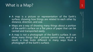
- 1. What is a Map? A map is a picture or representation of the Earth's surface, showing how things are related to each other by distance, direction, and size. Maps are a way of showing many things about a portion of the earth's surface on a flat piece of paper that can be carried and transported easily. A map is not a photograph of the Earth's surface. It can show many things that a picture cannot show, and as a result, a map looks different in many ways from a photograph of the Earth's surface. 1
- 2. What is a Map? 2
- 3. What is a Map? Maps are one of the most important media used to communicate information in exploration geology. Maps are a two dimensional representation of the surface of the earth and its features. Maps are a kind of shorthand language media with two main purposes: 1. To convey detailed information about a specific area, and 2. To indicate the position of the specific area relative to other parts of the earth. 3
- 4. What is a Map? The first objective is accomplished by recording information in graphic form, either directly from field observation or indirectly from air photographs or a wide variety of other source A geologic map records the distribution of rock and soil materials. It provides to identify and protect valuable resources, avoid risks from natural hazards. 4
- 5. What is a Geological Map? Geological map is a special purpose map made to show geological features, Rock units or geologic strata are shown by color or symbols to indicate where they are exposed at the surface. 5
- 6. What is a Geological Map? A geologic map is a map of the different types of rocks or structures that are on the surface of the Earth. By mapping different rock types and structures, geologists can determine the relationships between different rock formations which can then be used to find mineral resources, oil, and deposits. Geologic maps are used to interpret the structure,Stratigraphy, mineralogy, paleontology, and the historical record of the Earth's crust. Geologic maps are our most important and complete compilation of information about the solid Earth we live on, and we cannot understand the Earth without them. We use geologic maps and the fundamental information they provide in many ways. 6
- 7. The value of Geological Map Geologic maps are the single most important and valuable tool we have for understanding and living with the Earth around us. Their usefulness is so broad that geologic maps are the most requested scientific product produced by state and federal geological surveys. Geologic maps are central to almost any geological exploration projects. 7
- 8. Types of Geological Maps Main types of geological maps are: Topographic Maps, show a 3 dimensional world in 2 dimensions by using contour lines (dashed lines showing the third axis of the map) Areal Maps, show 2 dimensional view of the location by using XY coordinates, maybe used for showing, and comparing different aspects like lithology, structure etc. Block Diagrams is not a map actually but sometimes it is also considered as a geological map, because of showing data similar to a geological map 8
- 9. A Topographic view using contour lines to show elevation 9
- 10. An Aerial Map showing lithology of British Isles 10
- 11. A Block Diagram of a structure 11
- 12. How Geological maps are prepared? The aim of geologic mapping is to create a map which summarizes the geologic data gathered in the field. Every place that an observation is made, a sample is gathered, or any type of data collection takes place, it is positioned on the map at the appropriate X – Y coordinates. The map can be small scale and show much detail, or be large scale and generalized. Rock units are typically represented by colors. Instead of colors, certain symbols can be used. Different geologic mapping agencies and authorities have different standards for the colors and symbols to be used for rocks of different types and ages. 12
- 14. How Geologists Make a Geological Map Making a geologic map requires several decisions before the process actually begins. If one is going to explore some area: First, all previous geologic maps and data for an area needs to be sought, for a better understanding of that region. Maps of very large areas, such as states or provinces are commonly made by putting together and compiling more detailed, large scale maps of smaller areas. 14
- 15. How Geologists Make a Geological Map 15