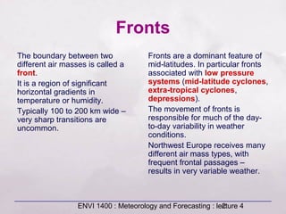
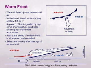
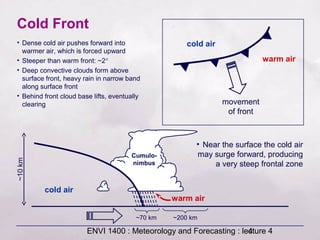
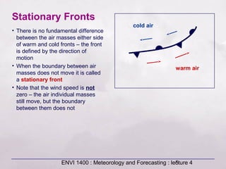
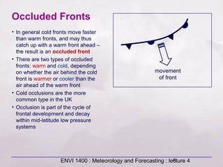
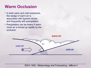
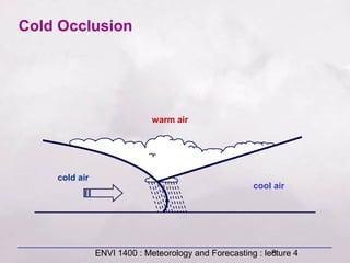
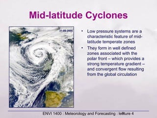
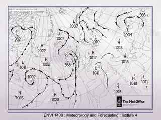
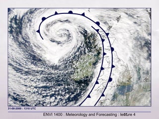
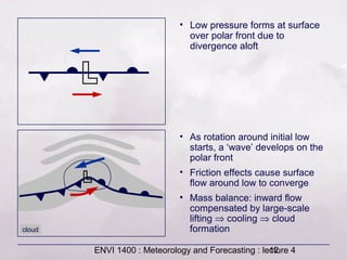
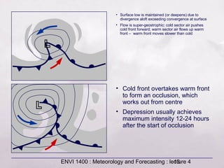
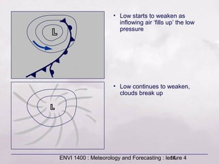
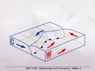
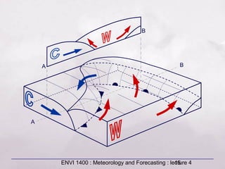
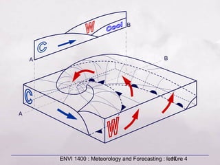
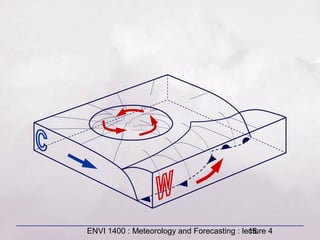
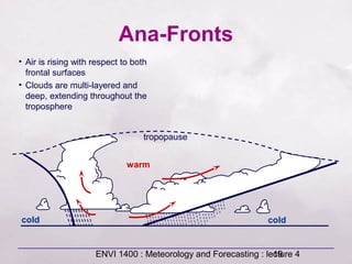
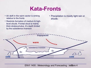
This document provides an overview of fronts and mid-latitude cyclones. It discusses the different types of fronts including warm fronts, cold fronts, stationary fronts and occluded fronts. It describes how mid-latitude cyclones form along polar fronts and the associated weather patterns. Key features of mid-latitude cyclones include the progression from warm to cold to occluded fronts as the cyclone evolves over time, bringing changing weather conditions to affected regions.
TEMPERATURE
COMPOSITION OF THE ATMOSPHERE
Layers of the ATMOSPHERE
WEATHER and CLIMATE
LATITUDINAL ZONES
ELEMENTS & CONTROLS OF WEATHER & CLIMATE
WARM MAJOR CURRENTS OF THE WORLD
Land Breeze & Sea Breeze
TEMPERATURE
COMPOSITION OF THE ATMOSPHERE
Layers of the ATMOSPHERE
WEATHER and CLIMATE
LATITUDINAL ZONES
ELEMENTS & CONTROLS OF WEATHER & CLIMATE
WARM MAJOR CURRENTS OF THE WORLD
Land Breeze & Sea Breeze
Part 1 of 3, most pilots loose the basics when they start flying due to numerous reasons. Whatever your reason, don't let not coming to this seminar be one of them. This three part series will fill in the memory gaps and show you how easy it can be to understand weather systems.
Unit 8 - Information and Communication Technology (Paper I).pdfThiyagu K
This slides describes the basic concepts of ICT, basics of Email, Emerging Technology and Digital Initiatives in Education. This presentations aligns with the UGC Paper I syllabus.
The Roman Empire A Historical Colossus.pdfkaushalkr1407
The Roman Empire, a vast and enduring power, stands as one of history's most remarkable civilizations, leaving an indelible imprint on the world. It emerged from the Roman Republic, transitioning into an imperial powerhouse under the leadership of Augustus Caesar in 27 BCE. This transformation marked the beginning of an era defined by unprecedented territorial expansion, architectural marvels, and profound cultural influence.
The empire's roots lie in the city of Rome, founded, according to legend, by Romulus in 753 BCE. Over centuries, Rome evolved from a small settlement to a formidable republic, characterized by a complex political system with elected officials and checks on power. However, internal strife, class conflicts, and military ambitions paved the way for the end of the Republic. Julius Caesar’s dictatorship and subsequent assassination in 44 BCE created a power vacuum, leading to a civil war. Octavian, later Augustus, emerged victorious, heralding the Roman Empire’s birth.
Under Augustus, the empire experienced the Pax Romana, a 200-year period of relative peace and stability. Augustus reformed the military, established efficient administrative systems, and initiated grand construction projects. The empire's borders expanded, encompassing territories from Britain to Egypt and from Spain to the Euphrates. Roman legions, renowned for their discipline and engineering prowess, secured and maintained these vast territories, building roads, fortifications, and cities that facilitated control and integration.
The Roman Empire’s society was hierarchical, with a rigid class system. At the top were the patricians, wealthy elites who held significant political power. Below them were the plebeians, free citizens with limited political influence, and the vast numbers of slaves who formed the backbone of the economy. The family unit was central, governed by the paterfamilias, the male head who held absolute authority.
Culturally, the Romans were eclectic, absorbing and adapting elements from the civilizations they encountered, particularly the Greeks. Roman art, literature, and philosophy reflected this synthesis, creating a rich cultural tapestry. Latin, the Roman language, became the lingua franca of the Western world, influencing numerous modern languages.
Roman architecture and engineering achievements were monumental. They perfected the arch, vault, and dome, constructing enduring structures like the Colosseum, Pantheon, and aqueducts. These engineering marvels not only showcased Roman ingenuity but also served practical purposes, from public entertainment to water supply.
A Strategic Approach: GenAI in EducationPeter Windle
Artificial Intelligence (AI) technologies such as Generative AI, Image Generators and Large Language Models have had a dramatic impact on teaching, learning and assessment over the past 18 months. The most immediate threat AI posed was to Academic Integrity with Higher Education Institutes (HEIs) focusing their efforts on combating the use of GenAI in assessment. Guidelines were developed for staff and students, policies put in place too. Innovative educators have forged paths in the use of Generative AI for teaching, learning and assessments leading to pockets of transformation springing up across HEIs, often with little or no top-down guidance, support or direction.
This Gasta posits a strategic approach to integrating AI into HEIs to prepare staff, students and the curriculum for an evolving world and workplace. We will highlight the advantages of working with these technologies beyond the realm of teaching, learning and assessment by considering prompt engineering skills, industry impact, curriculum changes, and the need for staff upskilling. In contrast, not engaging strategically with Generative AI poses risks, including falling behind peers, missed opportunities and failing to ensure our graduates remain employable. The rapid evolution of AI technologies necessitates a proactive and strategic approach if we are to remain relevant.
Francesca Gottschalk - How can education support child empowerment.pptxEduSkills OECD
Francesca Gottschalk from the OECD’s Centre for Educational Research and Innovation presents at the Ask an Expert Webinar: How can education support child empowerment?
Welcome to TechSoup New Member Orientation and Q&A (May 2024).pdfTechSoup
In this webinar you will learn how your organization can access TechSoup's wide variety of product discount and donation programs. From hardware to software, we'll give you a tour of the tools available to help your nonprofit with productivity, collaboration, financial management, donor tracking, security, and more.
The French Revolution, which began in 1789, was a period of radical social and political upheaval in France. It marked the decline of absolute monarchies, the rise of secular and democratic republics, and the eventual rise of Napoleon Bonaparte. This revolutionary period is crucial in understanding the transition from feudalism to modernity in Europe.
For more information, visit-www.vavaclasses.com
How to Make a Field invisible in Odoo 17Celine George
It is possible to hide or invisible some fields in odoo. Commonly using “invisible” attribute in the field definition to invisible the fields. This slide will show how to make a field invisible in odoo 17.
Operation “Blue Star” is the only event in the history of Independent India where the state went into war with its own people. Even after about 40 years it is not clear if it was culmination of states anger over people of the region, a political game of power or start of dictatorial chapter in the democratic setup.
The people of Punjab felt alienated from main stream due to denial of their just demands during a long democratic struggle since independence. As it happen all over the word, it led to militant struggle with great loss of lives of military, police and civilian personnel. Killing of Indira Gandhi and massacre of innocent Sikhs in Delhi and other India cities was also associated with this movement.
Embracing GenAI - A Strategic ImperativePeter Windle
Artificial Intelligence (AI) technologies such as Generative AI, Image Generators and Large Language Models have had a dramatic impact on teaching, learning and assessment over the past 18 months. The most immediate threat AI posed was to Academic Integrity with Higher Education Institutes (HEIs) focusing their efforts on combating the use of GenAI in assessment. Guidelines were developed for staff and students, policies put in place too. Innovative educators have forged paths in the use of Generative AI for teaching, learning and assessments leading to pockets of transformation springing up across HEIs, often with little or no top-down guidance, support or direction.
This Gasta posits a strategic approach to integrating AI into HEIs to prepare staff, students and the curriculum for an evolving world and workplace. We will highlight the advantages of working with these technologies beyond the realm of teaching, learning and assessment by considering prompt engineering skills, industry impact, curriculum changes, and the need for staff upskilling. In contrast, not engaging strategically with Generative AI poses risks, including falling behind peers, missed opportunities and failing to ensure our graduates remain employable. The rapid evolution of AI technologies necessitates a proactive and strategic approach if we are to remain relevant.
2. ENVI 1400 : Meteorology and Forecasting : lecture 42
Fronts
The boundary between two
different air masses is called a
front.
It is a region of significant
horizontal gradients in
temperature or humidity.
Typically 100 to 200 km wide –
very sharp transitions are
uncommon.
Fronts are a dominant feature of
mid-latitudes. In particular fronts
associated with low pressure
systems (mid-latitude cyclones,
extra-tropical cyclones,
depressions).
The movement of fronts is
responsible for much of the day-
to-day variability in weather
conditions.
Northwest Europe receives many
different air mass types, with
frequent frontal passages –
results in very variable weather.
3. ENVI 1400 : Meteorology and Forecasting : lecture 43
Warm Front
warm air
cool air
movement
of front
cool air
warm air
nimbo-stratus
alto-stratus
cirro-stratus
cirrus
~300 km ~500 km
• Warm air flows up over denser cold
air
• Inclination of frontal surface is very
shallow: 0.5 to 1°
• Approach of front signalled by high
cirrus or cirrostratus, cloud base
lowering as surface front
approaches.
• Rain starts ahead of surface front,
is widespread and persistent
• Skies clear quickly after passage of
surface front
~10km
4. ENVI 1400 : Meteorology and Forecasting : lecture 44
Cumulo-
nimbus
Cold Front
cold air
warm air
movement
of front
cold air
warm air
~70 km ~200 km
• Dense cold air pushes forward into
warmer air, which is forced upward
• Steeper than warm front: ~2°
• Deep convective clouds form above
surface front, heavy rain in narrow band
along surface front
• Behind front cloud base lifts, eventually
clearing
• Near the surface the cold air
may surge forward, producing
a very steep frontal zone
~10km
5. ENVI 1400 : Meteorology and Forecasting : lecture 45
Stationary Fronts
• There is no fundamental difference
between the air masses either side
of warm and cold fronts – the front
is defined by the direction of
motion
• When the boundary between air
masses does not move it is called
a stationary front
• Note that the wind speed is not
zero – the air individual masses
still move, but the boundary
between them does not
cold air
warm air
6. ENVI 1400 : Meteorology and Forecasting : lecture 46
Occluded Fronts
movement
of front
• In general cold fronts move faster
than warm fronts, and may thus
catch up with a warm front ahead –
the result is an occluded front
• There are two types of occluded
fronts: warm and cold, depending
on whether the air behind the cold
front is warmer or cooler than the
air ahead of the warm front
• Cold occlusions are the more
common type in the UK
• Occlusion is part of the cycle of
frontal development and decay
within mid-latitude low pressure
systems
7. ENVI 1400 : Meteorology and Forecasting : lecture 47
cold air
warm air
cool air
Warm Occlusion
• In both warm and cold occlusions,
the wedge of warm air is
associated with layered clouds,
and frequently with precipitation
• Precipitation can be heavy if warm
moist air is forced up rapidly by the
occlusion
8. ENVI 1400 : Meteorology and Forecasting : lecture 48
cold air
warm air
cool air
Cold Occlusion
9. ENVI 1400 : Meteorology and Forecasting : lecture 49
Mid-latitude Cyclones
• Low pressure systems are a
characteristic feature of mid-
latitude temperate zones
• They form in well defined
zones associated with the
polar front – which provides a
strong temperature gradient –
and convergent flow resulting
from the global circulation
31-08-2000
10. ENVI 1400 : Meteorology and Forecasting : lecture 410
11. ENVI 1400 : Meteorology and Forecasting : lecture 411
31-08-2000 : 1310 UTC
12. ENVI 1400 : Meteorology and Forecasting : lecture 412
• Low pressure forms at surface
over polar front due to
divergence aloft
• As rotation around initial low
starts, a ‘wave’ develops on the
polar front
• Friction effects cause surface
flow around low to converge
• Mass balance: inward flow
compensated by large-scale
lifting ⇒ cooling ⇒ cloud
formationcloud
13. ENVI 1400 : Meteorology and Forecasting : lecture 413
• Surface low is maintained (or deepens) due to
divergence aloft exceeding convergence at surface
• Flow is super-geostrophic: cold sector air pushes
cold front forward; warm sector air flows up warm
front – warm front moves slower than cold
• Cold front overtakes warm front
to form an occlusion, which
works out from centre
• Depression usually achieves
maximum intensity 12-24 hours
after the start of occlusion
14. ENVI 1400 : Meteorology and Forecasting : lecture 414
• Low starts to weaken as
inflowing air ‘fills up’ the low
pressure
• Low continues to weaken,
clouds break up
15. ENVI 1400 : Meteorology and Forecasting : lecture 415
16. ENVI 1400 : Meteorology and Forecasting : lecture 416
A
BA
B
17. ENVI 1400 : Meteorology and Forecasting : lecture 417
A
BA
B
18. ENVI 1400 : Meteorology and Forecasting : lecture 418
19. ENVI 1400 : Meteorology and Forecasting : lecture 419
Ana-Fronts
• Air is rising with respect to both
frontal surfaces
• Clouds are multi-layered and
deep, extending throughout the
troposphere
tropopause
cold
warm
cold
20. ENVI 1400 : Meteorology and Forecasting : lecture 420
Kata-Fronts
tropopause
Sc
Sc
subsidence inversion
• Air aloft in the warm sector is sinking
relative to the fronts
• Restricts formation of medium & high-
level clouds. Frontal cloud is mainly
thick stratocumulus, it’s depth limited
by the subsidence inversion
• Precipitation is mostly light rain or
drizzle.
cold
warm
cold
21. ENVI 1400 : Meteorology and Forecasting : lecture 421
Ana-cold fronts may occur
with kata-warm fronts, and
vice-versa.
Forecasting the extent of
rain associated with fronts is
complicated
– Most fronts are not ana- or
kata- along whole length, or
at all levels within the
troposphere
Some general guidance
may be obtained from
charts of vertical velocity (eg
from NCEP)
For short-term forecasts
(periods of hours) &
‘nowcasts’, rainfall radar
provide the best estimates
of rainfall.
22. ENVI 1400 : Meteorology and Forecasting : lecture 422
23. ENVI 1400 : Meteorology and Forecasting : lecture 423
L
L
500mb surface height (dm)
24. ENVI 1400 : Meteorology and Forecasting : lecture 424
upper wind
A
B
C
D
25. ENVI 1400 : Meteorology and Forecasting : lecture 425
Crossed-Winds Rule
If an observer stands with their back to the surface wind
and estimates the direction of the upper-level winds from
motion of high-level clouds, they can a) estimate their
position within a low pressure system, and hence b)
make a rough forecast:
– If upper wind from your LEFT (position A), the weather is likely to
deteriorate
– If upper wind from you RIGHT (position B), the weather is likely
to improve
– If upper wind is BEHIND or AHEAD of you (positions C, D), there
is likely to be little change in the weather
26. ENVI 1400 : Meteorology and Forecasting : lecture 426
0°
30°
60°
Polar Front
Mid-latitude
Jet Stream
Tropical
jet
27. ENVI 1400 : Meteorology and Forecasting : lecture 427
30
60
80
Major Frontal Zones Northern Hemisphere Winter
Atlantic
Polar Front
Pacific Polar Front
Canadian
Arctic Front
Atlantic/Asiatic
Arctic Front
Mediterranean
Front
28. ENVI 1400 : Meteorology and Forecasting : lecture 428
500 hPa height (m), and temperature anomaly (°C)
Editor's Notes
Term front coined in WW1 (by Norwegians – analogy to battle fronts: lines of conflict between different air masses - results in turmoil of bad weather
In practice a front is defined as stationary if it’s motion is negligible on a synoptic chart, speed of front < 5 knots / 2.5 m/s