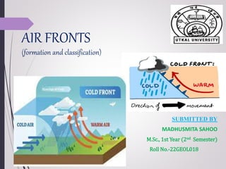
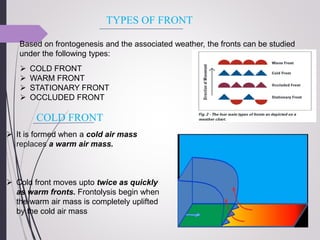
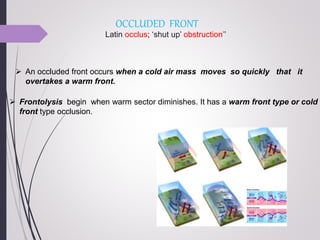
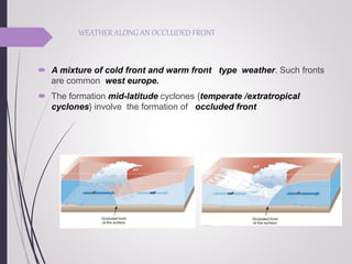
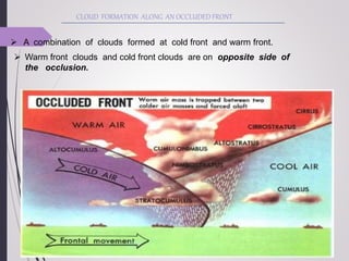
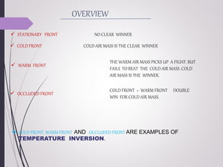
AIR FRONTS
(formation and classification)
SUBMITTED BY
MADHUSMITA SAHOO
M.Sc., 1st Year (2nd Semester)
Roll No.-22GEOL018
INTRODUCTION
FRONTOGENESIS
TYPES OF FRONTS
WEATHER AND CLOUD ASSOCIATED WITH
FRONT
OVERVIEW
CONTENTS
“AIR FRONT”
 Front means Facing something / interaction between two things.
 So air front is basically interaction between two opposite air masses .
 Front is a three dimensional boundary zone between two converging air
masses with different physical properties [Temperature, humidity , density
etc]
 when the 2 air masses meet ,due to the effect of the converging
atmospheric circulation, they do not merge readily.
 Fronts are features of mid- latitude region [ temperate region i.e. 400 – 650 N
and S ].
 They are unusual in tropical and polar regions
FRONTOGENESIS (FRONT
FORMATION)
The process of formation of a front is known as
Frontogenesis and dissipation of a front is known as
Frontolysis .
Frontogenesis involves convergence of two distinct air
masses. Frontolysis involves over riding of one of the air
mass by another.
Mid latitude/ temperate / extra tropical cyclones occur due
to frontogenesis.
Why fronts are formed at 40◦ –
60◦ latitude ?
TYPES OF FRONT
Based on frontogenesis and the associated weather, the fronts can be studied
under the following types:
 COLD FRONT
 WARM FRONT
 STATIONARY FRONT
 OCCLUDED FRONT
COLD FRONT
 It is formed when a cold air mass
replaces a warm air mass.
 Cold front moves upto twice as quickly
as warm fronts. Frontolysis begin when
the warm air mass is completely uplifted
by the cold air mass
WEATHER ALONG A COLD FRONT
 During the summer months Thunderstorms
are common in warm sector.
 In some regions like u.S.A tornadoes occur
in warm sector.
CLOUD FORMATION ALONG A COLD
FRONT
 Cirrus clouds, followed by lower, denser
altocumulus and altostratus.
 At actual front, dark nimbus and
cumulonimbus clouds cause heavy showers.
 A cold front passes off rapidly, but the weather
along it is violent.
WARM FRONT
 It is a sloping frontal surface along
which active movement of warm air
over cold air takes place. (Warm air
mass is too weak to beat the cold air
mass)
WEATHER ALONG A WARM FRONT
 The passage of warm front is marked by rise in temperature and pressure .
 Such fronts cause moderate to gentle precipitation over a large area over
several hours.
CLOUDS FORMATION ALONG WARM
FRONT
 Cirrus, stratus and nimbus (no cumulonimbus clouds as the
gradient is gentle)
 Cirrostratus clouds ahead of the warm front create a halo around
sun and moon .
STATIONARY FRONT
 In a stationary front two air masses meet and neither advances.
 The wind motion on both sides of the front is parallel to the front.
 Warm or cold front stops moving , so the name stationary front.
 A little rain may occur but this rarely causes heavy precipitation
WEATHER ALONG A STATIONARY
FRONT
Cumulonimbus clouds are formed, overrunning of warm air along
such a front causes frontal precipitation.
 Frontal cyclones migrating along a stationary front can dump heavy
amounts of precipitation.
OCCLUDED FRONT
 An occluded front occurs when a cold air mass moves so quickly that it
overtakes a warm front.
 Frontolysis begin when warm sector diminishes. It has a warm front type or cold
front type occlusion.
Latin occlus; ‘shut up’ obstruction’’
 A mixture of cold front and warm front type weather. Such fronts
are common west europe.
 The formation mid-latitude cyclones {temperate /extratropical
cyclones} involve the formation of occluded front
WEATHER ALONG AN OCCLUDED FRONT
CLOUD FORMATION ALONG AN OCCLUDED FRONT
 A combination of clouds formed at cold front and warm front.
 Warm front clouds and cold front clouds are on opposite side of
the occlusion.
 STATIONARY FRONT NO CLEAR WINNER
 COLD FRONT COLD AIR MASS IS THE CLEAR WINNER
 WARM FRONT
THE WARM AIR MASS PICKS UP A FIGHT. BUT
FAILS TO BEAT THE COLD AIR MASS. COLD
AIR MASS IS THE WINNER.
 OCCLUDED FRONT
COLD FRONT + WARM FRONT DOUBLE
WIN FOR COLD AIR MASS.
 COLD FRONT, WARM FRONT AND OCCLUDED FRONT ARE EXAMPLES OF
TEMPERATURE INVERSION.
OVERVIEW
REFERENCE:-
https://www.clearias.com/fronts/
https://www.studyiq.com/articles/fronts/
https://www.pmfias.com/fronts-frontogenesis-stationary-front-cold-front-
warm-front-occluded-front/
Fronts.pptx

Fronts.pptx

  • 1.
    AIR FRONTS (formation andclassification) SUBMITTED BY MADHUSMITA SAHOO M.Sc., 1st Year (2nd Semester) Roll No.-22GEOL018
  • 2.
    INTRODUCTION FRONTOGENESIS TYPES OF FRONTS WEATHERAND CLOUD ASSOCIATED WITH FRONT OVERVIEW CONTENTS
  • 3.
    “AIR FRONT”  Frontmeans Facing something / interaction between two things.  So air front is basically interaction between two opposite air masses .  Front is a three dimensional boundary zone between two converging air masses with different physical properties [Temperature, humidity , density etc]  when the 2 air masses meet ,due to the effect of the converging atmospheric circulation, they do not merge readily.  Fronts are features of mid- latitude region [ temperate region i.e. 400 – 650 N and S ].  They are unusual in tropical and polar regions
  • 4.
    FRONTOGENESIS (FRONT FORMATION) The processof formation of a front is known as Frontogenesis and dissipation of a front is known as Frontolysis . Frontogenesis involves convergence of two distinct air masses. Frontolysis involves over riding of one of the air mass by another. Mid latitude/ temperate / extra tropical cyclones occur due to frontogenesis.
  • 5.
    Why fronts areformed at 40◦ – 60◦ latitude ?
  • 7.
    TYPES OF FRONT Basedon frontogenesis and the associated weather, the fronts can be studied under the following types:  COLD FRONT  WARM FRONT  STATIONARY FRONT  OCCLUDED FRONT COLD FRONT  It is formed when a cold air mass replaces a warm air mass.  Cold front moves upto twice as quickly as warm fronts. Frontolysis begin when the warm air mass is completely uplifted by the cold air mass
  • 8.
    WEATHER ALONG ACOLD FRONT  During the summer months Thunderstorms are common in warm sector.  In some regions like u.S.A tornadoes occur in warm sector. CLOUD FORMATION ALONG A COLD FRONT  Cirrus clouds, followed by lower, denser altocumulus and altostratus.  At actual front, dark nimbus and cumulonimbus clouds cause heavy showers.  A cold front passes off rapidly, but the weather along it is violent.
  • 9.
    WARM FRONT  Itis a sloping frontal surface along which active movement of warm air over cold air takes place. (Warm air mass is too weak to beat the cold air mass) WEATHER ALONG A WARM FRONT  The passage of warm front is marked by rise in temperature and pressure .  Such fronts cause moderate to gentle precipitation over a large area over several hours.
  • 10.
    CLOUDS FORMATION ALONGWARM FRONT  Cirrus, stratus and nimbus (no cumulonimbus clouds as the gradient is gentle)  Cirrostratus clouds ahead of the warm front create a halo around sun and moon .
  • 11.
    STATIONARY FRONT  Ina stationary front two air masses meet and neither advances.  The wind motion on both sides of the front is parallel to the front.  Warm or cold front stops moving , so the name stationary front.  A little rain may occur but this rarely causes heavy precipitation
  • 12.
    WEATHER ALONG ASTATIONARY FRONT Cumulonimbus clouds are formed, overrunning of warm air along such a front causes frontal precipitation.  Frontal cyclones migrating along a stationary front can dump heavy amounts of precipitation.
  • 13.
    OCCLUDED FRONT  Anoccluded front occurs when a cold air mass moves so quickly that it overtakes a warm front.  Frontolysis begin when warm sector diminishes. It has a warm front type or cold front type occlusion. Latin occlus; ‘shut up’ obstruction’’
  • 14.
     A mixtureof cold front and warm front type weather. Such fronts are common west europe.  The formation mid-latitude cyclones {temperate /extratropical cyclones} involve the formation of occluded front WEATHER ALONG AN OCCLUDED FRONT
  • 15.
    CLOUD FORMATION ALONGAN OCCLUDED FRONT  A combination of clouds formed at cold front and warm front.  Warm front clouds and cold front clouds are on opposite side of the occlusion.
  • 16.
     STATIONARY FRONTNO CLEAR WINNER  COLD FRONT COLD AIR MASS IS THE CLEAR WINNER  WARM FRONT THE WARM AIR MASS PICKS UP A FIGHT. BUT FAILS TO BEAT THE COLD AIR MASS. COLD AIR MASS IS THE WINNER.  OCCLUDED FRONT COLD FRONT + WARM FRONT DOUBLE WIN FOR COLD AIR MASS.  COLD FRONT, WARM FRONT AND OCCLUDED FRONT ARE EXAMPLES OF TEMPERATURE INVERSION. OVERVIEW
  • 17.