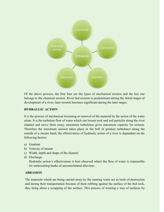
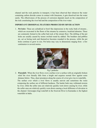
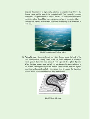
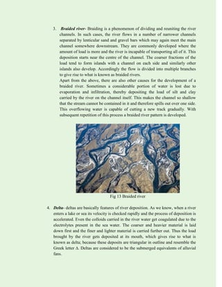
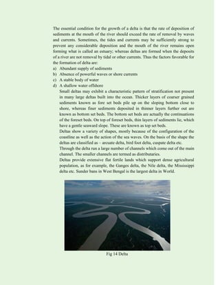
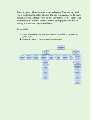
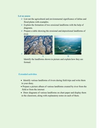
SlideShare a Scribd company logo
1 of 20
Download to read offline
Social Science II
Standard IX
State Council of Educational Research and Training (SCERT),
Kerala 2023
THE NATIONAL ANTHEM
Jana-gana-mana-adhinayaka, jaya he
Bharata-bhagya-vidhata.
Punjab-Sindh-Gujarat-Maratha
Dravida-Utkala-Banga
Vindhya-Himachala-Yamuna-Ganga
Uchchala-Jaladhi-taranga.
Tava shubha name jage,
Tava shubha asisa mage,
Gahe tava jaya gatha,
Jana-gana-mangala-dayaka jaya he
Bharata-bhagya-vidhata.
Jaya he, jaya he, jaya he, Jaya jaya jaya, jaya he
PLEDGE
India is my country. All Indians are my brothers and sisters. I love my country, and I am proud
of its rich and varied heritage. I shall always strive to be worthy of it.
I shall give my parents, teachers and all elders respect, and treat everyone with courtesy.
To my country and my people, I pledge my devotion. In their well-being and prosperity alone
lies my happiness
CONSTITUTION OF INDIA
Part IV A
FUNDAMENTAL DUTIES OF CITIZENS
ARTICLE 51 A
Fundamental Duties- It shall be the duty of every citizen of India:
(a) to abide by the Constitution and respect its ideals and institutions, the National Flag and the
National Anthem;
(b) to cherish and follow the noble ideals which inspired our national struggle for freedom;
(c) to uphold and protect the sovereignty, unity and integrity of India;
(d) to defend the country and render national service when called upon to do so;
(e) to promote harmony and the spirit of common brotherhood amongst all the people of India
transcending religious, linguistic and regional or sectional diversities; to renounce practices
derogatory to the dignity of women;
(f) to value and preserve the rich heritage of our composite culture;
(g) to protect and improve the natural environment including forests, lakes, rivers, wild life and
to have compassion for living creatures;
(h) to develop the scientific temper, humanism and the spirit of inquiry and reform; (i) to
safeguard public property and to abjure violence;
(j) to strive towards excellence in all spheres of individual and collective activity so that the
nation constantly rises to higher levels of endeavour and achievements;
(k) who is a parent or guardian to provide opportunities for education to his child or, as the case
may be, ward between age of six and fourteen years.
Text book development team
Vismaya M D
Soumya M S
Reshma U
Ludiya stanly S G
Lekshmi Sanal
Burney Jose
Ancy A S
RIVER: A GEOLOGICAL AGENT
Water is an important agent in bringing about changes near the surface of the earth. This is
possible it is recycled through the oceans, atmosphere and land. Solar radiation causes
evaporation of water from the surface of water bodies an due to transpiration of plants etc. the
moisture content of the atmosphere increases and under favorable conditions this water falls to
the earth in the form of rain, hail, sleet or snow. Falling on the earth’s surface, atmospheric
precipitation is distributed in a number of ways. The rain and melt waters are distributed over the
surface more or less evenly and this occurs only on a smooth slopes.
In general, river originates in mountainous regions. Little gutters converge to give rise to a
streamlet and the streamlets combine to form a stream at down slopes. Several streams unite to
form a river. A river is defined as a body of running water carrying sediments which flows along
a definite path. The path of the river is the river valley. The flow of water in a river is expressed
in terms of the volume passing through a point in a given time; this is known as the discharge of
the river.
GEOLOGICAL ACTION OF RIVER
Rivers carry excess water from the land to the sea. In doing so, they erode valleys and help in
shaping the earth’s surface. They transport rock debris and dissolved materials and eventually
they deposit most of their sediments in the oceans. River activity in combination with weathering
and mass wasting predominated by far over other types of erosion such important of the
geomorphic agents in bringing about the degradation of the land surface.
The geological activity of river is divided chiefly into three parts as
1. Erosion
2. Transportation
3. Deposition
EROSION
The term ‘erosion’ is applied for rock breakdown by the dynamic action of any geomorphic
agent like moving water, blowing wind, glaciers etc. It is usually defined as the sum total of the
process of wearing away of the rocks by the physical forces and chemical factors associated with
the natural agencies. A wide variety of processes are included in river erosion as shown below.
Landforms created by the erosional and depositional activities of rivers are called fluvial
landforms.
Of the above process, the first four are the types of mechanical erosion and the last one
belongs to the chemical erosion. River bed erosion is predominant during the initial stages of
development of a river; later erosion becomes significant during the later stages.
HYDRAULIC ACTION
It is the process of mechanical loosening or removal of the material by the action of the water
alone. It is the turbulent flow of water which can loosen rock and soil particles along the river
channel and move them away, maximum turbulence gives maximum capacity for erosion.
Therefore the maximum erosion takes place in the belt of greatest turbulence along the
outside of a stream bend, the effectiveness of hydraulic action of a river is dependent on the
following factors:
a) Gradient
b) Velocity of stream
c) Width, depth and shape of the channel
d) Discharge
Hydraulic action’s effectiveness is best observed where the flow of water is responsible
for undercutting banks of unconsolidated alluvium.
ABRASION
The materials which are being carried away by the running water act as tools of destruction
and during their transportation because of their rubbing against the surface of the bed rock,
they bring about a scrapping of the surface. This process of wearing a way of surfaces by
Erosion
Corrosion
Cavitation
Attrition
Abrasion
Hydraulic
action
mechanical processes such as rubbing, cutting, scratching, grinding, polishing etc, is known
as abrasion or corrosion.
Without the presence of rock particles, rivers cannot scratch and scour their channel or in
other words, the rock wastes which are being carried in the river current as load are
responsible for the abrasive action of the river. Abrasion may be vertical or lateral. While
vertical abrasion causes deepening of the channel, lateral abrasion gives rise to valley
widening, the abrasive action of the river is considered to be the most important means of
erosion in bed rock which are too strong to be affected by simple hydraulic action.
ATTRITION
The products of abrasion and hydraulic action are carried away in the river flow, which often
collide among themselves, with the bed rock and also with the sides during their transit and
in turn get themselves teared. This process of mechanical wear and tear of the transported
rock fragments through which big boulders are gradually reduced in size and finally reach
the size grade of sand and silt is known as attrition.
Since, in this process rock fragments in transit suffer mutual collision and repeated impacts,
their irregularities and angularities are worn out and they become spherical and rounded.
CAVITATION
It is sometimes considered as a type of hydraulic action. It is particularly observed where
river water suddenly acquires exceptionally a high velocity such as at waterfalls. Rapid
increase of velocity reduces the internal pressure in the water. As soon as the velocity is
decreased due to friction against the floor or sides of the channel, the internal pressure
increases again and the bubbles become unstable. The bubbles then collapse suddenly and
violently resulting in shock waves which deliver hammer like blows to the adjoining surface
producing a crop of rock fragments to e carried away by the fiver flow. This process thus
produces hollows in river beds which in due course are developed into pot holes.
Sometimes, highly turbulent rivers in rocky channels erode their beds by hydraulic plucking
in which blocks of bed rocks etc are lifted out by suction in strong eddied spiraling up
around vertical axes. This sucking out of the rock pieces produces depressions or holes
within the rock, which may develop into pot holes in due course of time.
Thus the rate of erosion is speeded up due to the process of cavitation.
CORROSION
The chemical processes of rock erosion by river water are known as corrosion or solution. In
the presence of aiding substances like alkali matter and gases like carbon dioxide etc, river
water is capable of dissolving matter from minerals that constitute the bed rock in the
channel and the rock particles in transport, it has been observed that whenever the water
containing carbon dioxide comes in contact with limestone, it gets dissolved into the water
easily. The effectiveness of the process of corrosion depends much on the composition of
the rock constituting the river bed and the composition of the river water.
IMPORTANT EROSIONAL FEATURES PRODUCED BY RIVER ACTION
1. Pot holes- These are cylindrical or bowl like depressions in the rocky beds of streams ,
which are excavated in the floors of the streams by extensive, localized abrasion. These
are commonly formed in the softer bed rock of the stream floor. The drilling of the pot
holes are usually caused by stones swirled round by eddied. The boulders and pebbles
etc. act as boring tools and themselves becomes rounded in the process, while the pot
holes continue to grow in size. Pot holes may vary in dimensions ranging from a few
centimeters to several metres.
Fig 1 potholes
2. Waterfalls- When the river flows over a surface over a surface with an originally broken
relief the river literally falls from a height and acquires normal flow against some
distance below. Thus, sheer precipices along the course of a river give rise to waterfalls.
The surface over which a river flows is usually uneven and sometimes the rocks
composing the surface are of different hardness. The harder beds may withstand erosion
by river, while the softer ones are relatively quickly worn down causing by river, while
the softer ones are relatively quickly worn down causing a local difference of elevation in
the channel. Gerosoppa (Jog) waterfall in the Swarvati River in Karnataka is the highest
waterfalls in India.
Fig 2 waterfall
3. River valleys- The typical river rises in the highlands and flows down due to the pull of
gravity. The channels carved out by the flow of running water are commonly known as
river valleys. These are negative landforms of varying size and shape. Three processes
such as valley- deepening, valley widening and valley lengthening are mainly
responsible for development of valleys.
Fig 3 River valley
4. Escarpments- These are erosional landforms produced by rivers in regions composed of
alternating beds of hard and soft rocks. The differential erosion of rocks giver rise to a
steep slope, called escarpment. This is usually developed in dipping beds with harder
rocks overlying the soft ones. Such structures are commonly referred to as homoclinical
structures. Because of the variation in resistance to erosion, the hard rocks are eroded at
a very slow rate whereas the soft ones are eroded comparatively at a rapid rate; this gives
rise to a steep slope on one side of the structure and a gentle slope on the other. The
steep slope is known as escarpment or scarp face.
Fig 4 Escarpment
There are a number of similar erosional features as follows:
a) Hogbacks - These are sharp crested often saw tooth ridge formed of the upturned
edge of a resistant rock layer of sandstone, limestone or lava. In these cases, the
beds dip at a high angle, roughly in excess of 45, so that the dip slope becomes
almost as steep as the escarpment.
Fig 4.a Hogbacks
b) Cuestas - These erosional landforms are developed on resistant strata having low to
moderate dip. This has the shape of an asymmetric low ridge or hill belt with a steep
scarp on one side and a gentle slope on the other. Majority of the cuestas are
associated with coastal plains.
c) Mesa – In regions of horizontal strata in which isolated portion of land is capped by
a hard, erosion resistant bed, the erosional landforms produced will have an isolated
table land area with steep sides commonly known as mesa.
d) Butte- with continued erosion of the sides a mesa is reduced to a smaller flat topped
hill, known as butte. This represents the final remnant of a resistant rock layer in a
region of horizontal strata. Such features in South Africa are called Kopjes.
5. Peneplain – Peneplain is the term used for the nearly smooth erosion surface of
relatively low relief and altitude which covers a large area. This is a landform, which is
the ultimate of the erosion cycle and it evolves in a temperate humid climate. Here the
slope is not sufficient to move the products of erosion and weathering
The surface of the peneplains may be dotted here and here by a relatively few, small
rounded hills, underlain by resistant rocks. These hillocks made up of harder, durable
and resistant rocks on the surface of the peneplains are termed as Monad nocks, which
are the remnants of the pre existing country which could survive the vehemence of
fluvial erosion.
6. Pediments- These are the erosional landforms mostly found in the arid regions. The
landform is a gently sloping plain worn down by scarp retreat. They are usually located
in the piedmont area, fringing an upland massif, but sometimes in wider low land zones.
They may or may not be covered by a thin veneer of alluvium but scattered over it are
rock fragments, some brought by running water from the adjacent mountains and some
derived by weathering from those immediately beneath. Retreat of the mountain slope
lengthens the pediments at its upslope edge.
The vast plains formed by the convergence of many pediments are termed as pediplains.
It consists of areas of pediments merging with surrounding alluvial fans and playa
surfaces. Pediplains are often considered as analogous to peneplains.
Fig 6 Pediments
7. Wadies – these are the channels formed during the rains in desert or arid regions and are
also known as washes.
Fig 7 Wadies
8. River terrace- These are erosional features consisting of several step like plains along
the side of a river valley. As we know, in the absence of tectonic disturbance, the river
attains a profile of equilibrium in due course of time and there will be a marked growth
of lateral erosion and deposition; the down cutting of the valley gets stopped and the
valley becomes nearly a plain. But with the subsequent revival of tectonic movements
when the source region is uplifted the gradient of the river increases resulting in the
increased of the velocity of the river. This will again start down cutting of the valley
floor and development of topographic features which are characteristic of a river in its
youth stag. This phenomenon of development of youthful topographic features in a
landmass having stable features is known as Rejuvenation.
Fig 8 River terraces
9. Badlands- These are rugged land surface of steep slopes, which are developed on weal
clay formations of clay rich regolith by fluvial erosion too rapid to permit plant growth
and soil formation. Clay and silt formation have little permeability as such there is little
infiltration of water. Besides, they are weak and yield readily to the attack of running
water. Therefore, due to pronounced erosion, the terrain constituted of argillaceous rocks
is intricately dissected by gullies and ravines, such terrains are known as badlands.
Fig 9 Badlands
TRANSPORTATION
The work carried out by a river is related to the energy available to it. Each river has a
certain quantity of potential energy determined by the height of its source region and the
volume of water entering the river system. This energy is converted to kinetic energy as
it moves through the system. The products of both the fluvial erosion and weathering
constitute the load of the river which are carried downstream along with the flow of
running water. That is to say that river transports its load due to the kinetic energy
associated with its flow.
DEPOSITION
Deposition of the transported materials takes place where the river’s capacity or
transporting ability is reduced. It usually occurs when the following conditions are met
a) Decrease in the velocity of the river
b) Decrease in slope or gradient
c) Decrease in volume of water
d) Change in channels
e) Chemical precipitation
All the above factors diminish the velocity of the river and influence the deposition
of sediments carried by it. Deposits, thus formed are called fluvial deposits.
IMPORTANT DEPOSITIONAL FEATURES PRODUCED BY RIVER
ACTION
1. Alluvial fans and cones- When streams flow abruptly from steeper to gentler
gradients, as at the base of a mountain or ridge, its velocity is checked and the
huge quantities of material carried by the river are dropped there giving rise to a
broad, low cone shaped deposit called an alluvial fan. Thus alluvial fans form
where a stream leaves a confined valley and enters a flatter region. The material
constituting a fan includes coarse boulders and pebbles at its head to finer
material down its slope.
The term alluvial fan is commonly used when the slope of the deposit is below
10 degree and alluvial cone when the slope is from 10 to 50 degrees.
A series of adjacent fans may in time coalesce to form an extensive piedmont
alluvial plain, also known as ‘Bajada’.
Fig 10
2. Flood plain deposits- Flood plains are areas of low and relatively flat land
bordering the channel on one or both the sides at bank level. These areas are
readily submerged under water during flood time, when the river water overtops
the banks of the channel and rises above the channel at low water. Deposits
formed on floodplain by flood water outside the actual channel are known as
over bank deposits.
A number of features are associated with the floodplains, which are as follows:
a) Meanders and oxbow lakes- dominating the flood plain is the meandering
river channel,i.e; the river flows across the flood plain in broad sweeping
curves, known as meanders. Meanders are common where the gradient of a
river becomes extremely low. In a flood plain a slight obstacle or accidental
irregularity usually causes a deviation of the current with the initiation of a
bend. Once started the bends tend to grow and gradually become more
pronounced. The water flows faster around outside of the bend and is slow on
the inner curve. Accordingly erosion becomes more towards the outer side of
each bend which is also termed as the under-cut side. At the same time where
starts deposition towards the inner side of each bend forming what is known
as the slip off slope. Thus, the river shifts its channel towards the outer band
and leaves gently rounded slip off slope on the inside of the growing curve.
A meander grows until it becomes bulb shaped with a narrow neck, because
of the constant broadening of a river’s bend during the erosion of the outer
bank and deposition on the inner bank. During floods, the increased power of
the flow may carry the stream, across this neck. As a result, the river
straightens its channel. The former meander, remains as a backwater for some
time and the entrances to it gradually get silted up since the river follows the
shortest course and the water in the meander is still. Thus a meander loop gets
abandoned. This phenomenon is called a cut off. The abandoned channel thus
constitutes a loop shaped lake known as an oxbow lake or horse shoe lake.
The deposits formed at the slip off slope of a meandering river are known as
point bar.
Fig 11 Meanders and Oxbow lakes
b) Natural levees – these are broad, low ridges formed along the bank of the
river during floods. During floods, when the entire floodplain is inundated,
water spreads from the main channel over adjacent flood plain deposits.
When the flood retreats, sand and silt etc. are deposited in a zone adjacent to
the channel forming low ridges that parallel a river course. They are highest
near the river bank and gradually slope away from it, because the deposition
is more nearer to the channel and decrease away from it.
Fig 12 Natural levees
3. Braided river- Braiding is a phenomenon of dividing and reuniting the river
channels. In such cases, the river flows in a number of narrower channels
separated by lenticular sand and gravel bars which may again meet the main
channel somewhere downstream. They are commonly developed where the
amount of load is more and the river is incapable of transporting all of it. This
deposition starts near the centre of the channel. The coarser fractions of the
load tend to form islands with a channel on each side and similarly other
islands also develop. Accordingly the flow is divided into multiple branches
to give rise to what is known as braided rivers.
Apart from the above, there are also other causes for the development of a
braided river. Sometimes a considerable portion of water is lost due to
evaporation and infiltration, thereby depositing the load of silt and clay
carried by the river on the channel itself. This makes the channel so shallow
that the stream cannot be contained in it and therefore spills out over one side.
This overflowing water is capable of cutting a new track gradually. With
subsequent repetition of this process a braided river pattern is developed.
Fig 13 Braided river
4. Delta- deltas are basically features of river deposition. As we know, when a river
enters a lake or sea its velocity is checked rapidly and the process of deposition is
accelerated. Even the colloids carried in the river water get coagulated due to the
electrolytes present in the sea water. The coarser and heavier material is laid
down first and the finer and lighter material is carried further out. Thus the load
brought by the river gets deposited at its mouth, which gives rise to what is
known as delta; because these deposits are triangular in outline and resemble the
Greek letter ∆. Deltas are considered to be the submerged equivalents of alluvial
fans.
The essential condition for the growth of a delta is that the rate of deposition of
sediments at the mouth of the river should exceed the rate of removal by waves
and currents. Sometimes, the tides and currents may be sufficiently strong to
prevent any considerable deposition and the mouth of the river remains open
forming what is called an estuary; whereas deltas are formed when the deposits
of a river are not removal by tidal or other currents. Thus the factors favorable for
the formation of delta are:
a) Abundant supply of sediments
b) Absence of powerful waves or shore currents
c) A stable body of water
d) A shallow water offshore
Small deltas may exhibit a characteristic pattern of stratification not present
in many large deltas built into the ocean. Thicker layers of coarser grained
sediments known as fore set beds pile up on the sloping bottom close to
shore, whereas finer sediments deposited in thinner layers further out are
known as bottom set beds. The bottom set beds are actually the continuations
of the foreset beds. On top of foreset beds, thin layers of sediments lie, which
have a gentle seaward slope. These are known as top set beds.
Deltas show a variety of shapes, mostly because of the configuration of the
coastline as well as the action of the sea waves. On the basis of the shape the
deltas are classified as – arcuate delta, bird foot delta, cuspate delta etc.
Through the delta run a large number of channels which come out of the main
channel. The smaller channels are termed as distributaries.
Deltas provide extensive flat fertile lands which support dense agricultural
population, as for example, the Ganges delta, the Nile delta, the Mississippi
delta etc. Sunder bans in West Bengal is the largest delta in World.
Fig 14 Delta
Rivers are powerful and dynamic geological agents. They may paly vital
role in modifying the surface of earth. The land forms created by the rivers
not only provide aesthetic beauty but also very helpful for the livelihood of
both animals and humans. But now, various anthropogenic activities are
leading to destruction of these landforms.
In nut shell…
 Rivers are most important geological agents in the creation of landforms on
earth’s surface.
 Landforms created by rivers are called fluvial erosion.
Running water
Erosional
landforms
Potholes Waterfalls Rivervalleys Escarpments
Hogbacks
Cuestas
Mesa
Butte
Peneplain Wadies Badlands
River
terraces
Depositional
landforms
Alluvial fans
and cones
Flooded plain
deposits
Meanders and
Oxbow lakes
Natural levees
Braided River
Delta
Let us assess
 List out the agricultural and environmental significance of deltas and
flood plains with examples.
 Explain the formation of two erosional landforms with the help of
diagrams.
 Prepare a table showing the erosional and depositional landforms of
river.

A B
Identify the landforms shown in picture and explain how they are
formed.
Extended activities
 Identify various landforms of rivers during field trips and write them
in your diary.
 Prepare a picture album of various landforms created by river from the
field or from the internet
 Draw diagrams of various landforms on chart paper and display them
in the classroom, along with explanatory notes on each of them.

More Related Content

Similar to digital text.pdf

Revision lesson 40 minutes
Revision lesson 40 minutesRevision lesson 40 minutes
Revision lesson 40 minutes
eshuttleworth
 
Rivers - George Mather, Chris Hancox, Alex Owen and Michael Soley
Rivers - George Mather, Chris Hancox, Alex Owen and Michael SoleyRivers - George Mather, Chris Hancox, Alex Owen and Michael Soley
Rivers - George Mather, Chris Hancox, Alex Owen and Michael Soley
Keith Phipps
 
Geologic Action of river.pdf
Geologic Action of river.pdfGeologic Action of river.pdf
Geologic Action of river.pdf
kaustubhpetare
 

Similar to digital text.pdf (20)

Revision lesson 40 minutes
Revision lesson 40 minutesRevision lesson 40 minutes
Revision lesson 40 minutes
 
Revision lesson 40 minutes
Revision lesson 40 minutesRevision lesson 40 minutes
Revision lesson 40 minutes
 
Four types of caves
Four types of cavesFour types of caves
Four types of caves
 
River
RiverRiver
River
 
weathering
weatheringweathering
weathering
 
Rivers - George Mather, Chris Hancox, Alex Owen and Michael Soley
Rivers - George Mather, Chris Hancox, Alex Owen and Michael SoleyRivers - George Mather, Chris Hancox, Alex Owen and Michael Soley
Rivers - George Mather, Chris Hancox, Alex Owen and Michael Soley
 
Revision pack 2014 - GCSE Geography OCR B
Revision pack 2014 - GCSE Geography OCR BRevision pack 2014 - GCSE Geography OCR B
Revision pack 2014 - GCSE Geography OCR B
 
Rivers Revision
Rivers RevisionRivers Revision
Rivers Revision
 
Erosion and transportation
Erosion  and transportationErosion  and transportation
Erosion and transportation
 
EROSION PROCESSES IN NEW ZEALAND
EROSION PROCESSES IN NEW ZEALANDEROSION PROCESSES IN NEW ZEALAND
EROSION PROCESSES IN NEW ZEALAND
 
Erosion Ppt
Erosion PptErosion Ppt
Erosion Ppt
 
Geologic Action of river.pdf
Geologic Action of river.pdfGeologic Action of river.pdf
Geologic Action of river.pdf
 
Geological action of river
Geological action of riverGeological action of river
Geological action of river
 
Assignment on: Runoff and flooding (Drainage Pattern, Stream Flow Velocity, R...
Assignment on: Runoff and flooding (Drainage Pattern, Stream Flow Velocity, R...Assignment on: Runoff and flooding (Drainage Pattern, Stream Flow Velocity, R...
Assignment on: Runoff and flooding (Drainage Pattern, Stream Flow Velocity, R...
 
Hydrology
HydrologyHydrology
Hydrology
 
soil erosion and its causes .pptx
soil erosion and its causes .pptxsoil erosion and its causes .pptx
soil erosion and its causes .pptx
 
Geology
GeologyGeology
Geology
 
earth and life 5.pptx
earth and life 5.pptxearth and life 5.pptx
earth and life 5.pptx
 
Unit4
Unit4Unit4
Unit4
 
Erosion
ErosionErosion
Erosion
 

More from VismayaMD (12)

innovative 3rd.pdf
innovative 3rd.pdfinnovative 3rd.pdf
innovative 3rd.pdf
 
innovative work.pdf
innovative work.pdfinnovative work.pdf
innovative work.pdf
 
DIGITAL_PROFILE[1].pptx
DIGITAL_PROFILE[1].pptxDIGITAL_PROFILE[1].pptx
DIGITAL_PROFILE[1].pptx
 
project gender.pdf
project gender.pdfproject gender.pdf
project gender.pdf
 
Water Cycle.pptx
Water Cycle.pptxWater Cycle.pptx
Water Cycle.pptx
 
DIGITAL PROFILE.pptx
DIGITAL PROFILE.pptxDIGITAL PROFILE.pptx
DIGITAL PROFILE.pptx
 
International understanding
International understandingInternational understanding
International understanding
 
International understanding
International understandingInternational understanding
International understanding
 
Computer Assisted Instruction
Computer Assisted InstructionComputer Assisted Instruction
Computer Assisted Instruction
 
International understanding
International understandingInternational understanding
International understanding
 
International understanding
International understandingInternational understanding
International understanding
 
Projected and non_projected_aids
Projected and non_projected_aidsProjected and non_projected_aids
Projected and non_projected_aids
 

Recently uploaded

Gardella_Mateo_IntellectualProperty.pdf.
Gardella_Mateo_IntellectualProperty.pdf.Gardella_Mateo_IntellectualProperty.pdf.
Gardella_Mateo_IntellectualProperty.pdf.
MateoGardella
 
1029-Danh muc Sach Giao Khoa khoi 6.pdf
1029-Danh muc Sach Giao Khoa khoi  6.pdf1029-Danh muc Sach Giao Khoa khoi  6.pdf
1029-Danh muc Sach Giao Khoa khoi 6.pdf
QucHHunhnh
 
Beyond the EU: DORA and NIS 2 Directive's Global Impact
Beyond the EU: DORA and NIS 2 Directive's Global ImpactBeyond the EU: DORA and NIS 2 Directive's Global Impact
Beyond the EU: DORA and NIS 2 Directive's Global Impact
PECB
 
An Overview of Mutual Funds Bcom Project.pdf
An Overview of Mutual Funds Bcom Project.pdfAn Overview of Mutual Funds Bcom Project.pdf
An Overview of Mutual Funds Bcom Project.pdf
SanaAli374401
 

Recently uploaded (20)

Z Score,T Score, Percential Rank and Box Plot Graph
Z Score,T Score, Percential Rank and Box Plot GraphZ Score,T Score, Percential Rank and Box Plot Graph
Z Score,T Score, Percential Rank and Box Plot Graph
 
Measures of Dispersion and Variability: Range, QD, AD and SD
Measures of Dispersion and Variability: Range, QD, AD and SDMeasures of Dispersion and Variability: Range, QD, AD and SD
Measures of Dispersion and Variability: Range, QD, AD and SD
 
Advance Mobile Application Development class 07
Advance Mobile Application Development class 07Advance Mobile Application Development class 07
Advance Mobile Application Development class 07
 
psychiatric nursing HISTORY COLLECTION .docx
psychiatric  nursing HISTORY  COLLECTION  .docxpsychiatric  nursing HISTORY  COLLECTION  .docx
psychiatric nursing HISTORY COLLECTION .docx
 
Gardella_Mateo_IntellectualProperty.pdf.
Gardella_Mateo_IntellectualProperty.pdf.Gardella_Mateo_IntellectualProperty.pdf.
Gardella_Mateo_IntellectualProperty.pdf.
 
APM Welcome, APM North West Network Conference, Synergies Across Sectors
APM Welcome, APM North West Network Conference, Synergies Across SectorsAPM Welcome, APM North West Network Conference, Synergies Across Sectors
APM Welcome, APM North West Network Conference, Synergies Across Sectors
 
1029-Danh muc Sach Giao Khoa khoi 6.pdf
1029-Danh muc Sach Giao Khoa khoi  6.pdf1029-Danh muc Sach Giao Khoa khoi  6.pdf
1029-Danh muc Sach Giao Khoa khoi 6.pdf
 
fourth grading exam for kindergarten in writing
fourth grading exam for kindergarten in writingfourth grading exam for kindergarten in writing
fourth grading exam for kindergarten in writing
 
This PowerPoint helps students to consider the concept of infinity.
This PowerPoint helps students to consider the concept of infinity.This PowerPoint helps students to consider the concept of infinity.
This PowerPoint helps students to consider the concept of infinity.
 
Mehran University Newsletter Vol-X, Issue-I, 2024
Mehran University Newsletter Vol-X, Issue-I, 2024Mehran University Newsletter Vol-X, Issue-I, 2024
Mehran University Newsletter Vol-X, Issue-I, 2024
 
Nutritional Needs Presentation - HLTH 104
Nutritional Needs Presentation - HLTH 104Nutritional Needs Presentation - HLTH 104
Nutritional Needs Presentation - HLTH 104
 
Unit-IV; Professional Sales Representative (PSR).pptx
Unit-IV; Professional Sales Representative (PSR).pptxUnit-IV; Professional Sales Representative (PSR).pptx
Unit-IV; Professional Sales Representative (PSR).pptx
 
Código Creativo y Arte de Software | Unidad 1
Código Creativo y Arte de Software | Unidad 1Código Creativo y Arte de Software | Unidad 1
Código Creativo y Arte de Software | Unidad 1
 
Beyond the EU: DORA and NIS 2 Directive's Global Impact
Beyond the EU: DORA and NIS 2 Directive's Global ImpactBeyond the EU: DORA and NIS 2 Directive's Global Impact
Beyond the EU: DORA and NIS 2 Directive's Global Impact
 
How to Give a Domain for a Field in Odoo 17
How to Give a Domain for a Field in Odoo 17How to Give a Domain for a Field in Odoo 17
How to Give a Domain for a Field in Odoo 17
 
Web & Social Media Analytics Previous Year Question Paper.pdf
Web & Social Media Analytics Previous Year Question Paper.pdfWeb & Social Media Analytics Previous Year Question Paper.pdf
Web & Social Media Analytics Previous Year Question Paper.pdf
 
Accessible design: Minimum effort, maximum impact
Accessible design: Minimum effort, maximum impactAccessible design: Minimum effort, maximum impact
Accessible design: Minimum effort, maximum impact
 
Introduction to Nonprofit Accounting: The Basics
Introduction to Nonprofit Accounting: The BasicsIntroduction to Nonprofit Accounting: The Basics
Introduction to Nonprofit Accounting: The Basics
 
An Overview of Mutual Funds Bcom Project.pdf
An Overview of Mutual Funds Bcom Project.pdfAn Overview of Mutual Funds Bcom Project.pdf
An Overview of Mutual Funds Bcom Project.pdf
 
Sports & Fitness Value Added Course FY..
Sports & Fitness Value Added Course FY..Sports & Fitness Value Added Course FY..
Sports & Fitness Value Added Course FY..
 

digital text.pdf

  • 1. Social Science II Standard IX State Council of Educational Research and Training (SCERT), Kerala 2023
  • 2. THE NATIONAL ANTHEM Jana-gana-mana-adhinayaka, jaya he Bharata-bhagya-vidhata. Punjab-Sindh-Gujarat-Maratha Dravida-Utkala-Banga Vindhya-Himachala-Yamuna-Ganga Uchchala-Jaladhi-taranga. Tava shubha name jage, Tava shubha asisa mage, Gahe tava jaya gatha, Jana-gana-mangala-dayaka jaya he Bharata-bhagya-vidhata. Jaya he, jaya he, jaya he, Jaya jaya jaya, jaya he PLEDGE India is my country. All Indians are my brothers and sisters. I love my country, and I am proud of its rich and varied heritage. I shall always strive to be worthy of it. I shall give my parents, teachers and all elders respect, and treat everyone with courtesy. To my country and my people, I pledge my devotion. In their well-being and prosperity alone lies my happiness
  • 3. CONSTITUTION OF INDIA Part IV A FUNDAMENTAL DUTIES OF CITIZENS ARTICLE 51 A Fundamental Duties- It shall be the duty of every citizen of India: (a) to abide by the Constitution and respect its ideals and institutions, the National Flag and the National Anthem; (b) to cherish and follow the noble ideals which inspired our national struggle for freedom; (c) to uphold and protect the sovereignty, unity and integrity of India; (d) to defend the country and render national service when called upon to do so; (e) to promote harmony and the spirit of common brotherhood amongst all the people of India transcending religious, linguistic and regional or sectional diversities; to renounce practices derogatory to the dignity of women; (f) to value and preserve the rich heritage of our composite culture; (g) to protect and improve the natural environment including forests, lakes, rivers, wild life and to have compassion for living creatures; (h) to develop the scientific temper, humanism and the spirit of inquiry and reform; (i) to safeguard public property and to abjure violence; (j) to strive towards excellence in all spheres of individual and collective activity so that the nation constantly rises to higher levels of endeavour and achievements; (k) who is a parent or guardian to provide opportunities for education to his child or, as the case may be, ward between age of six and fourteen years.
  • 4. Text book development team Vismaya M D Soumya M S Reshma U Ludiya stanly S G Lekshmi Sanal Burney Jose Ancy A S
  • 5. RIVER: A GEOLOGICAL AGENT Water is an important agent in bringing about changes near the surface of the earth. This is possible it is recycled through the oceans, atmosphere and land. Solar radiation causes evaporation of water from the surface of water bodies an due to transpiration of plants etc. the moisture content of the atmosphere increases and under favorable conditions this water falls to the earth in the form of rain, hail, sleet or snow. Falling on the earth’s surface, atmospheric precipitation is distributed in a number of ways. The rain and melt waters are distributed over the surface more or less evenly and this occurs only on a smooth slopes. In general, river originates in mountainous regions. Little gutters converge to give rise to a streamlet and the streamlets combine to form a stream at down slopes. Several streams unite to form a river. A river is defined as a body of running water carrying sediments which flows along a definite path. The path of the river is the river valley. The flow of water in a river is expressed in terms of the volume passing through a point in a given time; this is known as the discharge of the river. GEOLOGICAL ACTION OF RIVER Rivers carry excess water from the land to the sea. In doing so, they erode valleys and help in shaping the earth’s surface. They transport rock debris and dissolved materials and eventually they deposit most of their sediments in the oceans. River activity in combination with weathering and mass wasting predominated by far over other types of erosion such important of the geomorphic agents in bringing about the degradation of the land surface. The geological activity of river is divided chiefly into three parts as 1. Erosion 2. Transportation 3. Deposition EROSION The term ‘erosion’ is applied for rock breakdown by the dynamic action of any geomorphic agent like moving water, blowing wind, glaciers etc. It is usually defined as the sum total of the process of wearing away of the rocks by the physical forces and chemical factors associated with the natural agencies. A wide variety of processes are included in river erosion as shown below. Landforms created by the erosional and depositional activities of rivers are called fluvial landforms.
  • 6. Of the above process, the first four are the types of mechanical erosion and the last one belongs to the chemical erosion. River bed erosion is predominant during the initial stages of development of a river; later erosion becomes significant during the later stages. HYDRAULIC ACTION It is the process of mechanical loosening or removal of the material by the action of the water alone. It is the turbulent flow of water which can loosen rock and soil particles along the river channel and move them away, maximum turbulence gives maximum capacity for erosion. Therefore the maximum erosion takes place in the belt of greatest turbulence along the outside of a stream bend, the effectiveness of hydraulic action of a river is dependent on the following factors: a) Gradient b) Velocity of stream c) Width, depth and shape of the channel d) Discharge Hydraulic action’s effectiveness is best observed where the flow of water is responsible for undercutting banks of unconsolidated alluvium. ABRASION The materials which are being carried away by the running water act as tools of destruction and during their transportation because of their rubbing against the surface of the bed rock, they bring about a scrapping of the surface. This process of wearing a way of surfaces by Erosion Corrosion Cavitation Attrition Abrasion Hydraulic action
  • 7. mechanical processes such as rubbing, cutting, scratching, grinding, polishing etc, is known as abrasion or corrosion. Without the presence of rock particles, rivers cannot scratch and scour their channel or in other words, the rock wastes which are being carried in the river current as load are responsible for the abrasive action of the river. Abrasion may be vertical or lateral. While vertical abrasion causes deepening of the channel, lateral abrasion gives rise to valley widening, the abrasive action of the river is considered to be the most important means of erosion in bed rock which are too strong to be affected by simple hydraulic action. ATTRITION The products of abrasion and hydraulic action are carried away in the river flow, which often collide among themselves, with the bed rock and also with the sides during their transit and in turn get themselves teared. This process of mechanical wear and tear of the transported rock fragments through which big boulders are gradually reduced in size and finally reach the size grade of sand and silt is known as attrition. Since, in this process rock fragments in transit suffer mutual collision and repeated impacts, their irregularities and angularities are worn out and they become spherical and rounded. CAVITATION It is sometimes considered as a type of hydraulic action. It is particularly observed where river water suddenly acquires exceptionally a high velocity such as at waterfalls. Rapid increase of velocity reduces the internal pressure in the water. As soon as the velocity is decreased due to friction against the floor or sides of the channel, the internal pressure increases again and the bubbles become unstable. The bubbles then collapse suddenly and violently resulting in shock waves which deliver hammer like blows to the adjoining surface producing a crop of rock fragments to e carried away by the fiver flow. This process thus produces hollows in river beds which in due course are developed into pot holes. Sometimes, highly turbulent rivers in rocky channels erode their beds by hydraulic plucking in which blocks of bed rocks etc are lifted out by suction in strong eddied spiraling up around vertical axes. This sucking out of the rock pieces produces depressions or holes within the rock, which may develop into pot holes in due course of time. Thus the rate of erosion is speeded up due to the process of cavitation. CORROSION The chemical processes of rock erosion by river water are known as corrosion or solution. In the presence of aiding substances like alkali matter and gases like carbon dioxide etc, river water is capable of dissolving matter from minerals that constitute the bed rock in the
  • 8. channel and the rock particles in transport, it has been observed that whenever the water containing carbon dioxide comes in contact with limestone, it gets dissolved into the water easily. The effectiveness of the process of corrosion depends much on the composition of the rock constituting the river bed and the composition of the river water. IMPORTANT EROSIONAL FEATURES PRODUCED BY RIVER ACTION 1. Pot holes- These are cylindrical or bowl like depressions in the rocky beds of streams , which are excavated in the floors of the streams by extensive, localized abrasion. These are commonly formed in the softer bed rock of the stream floor. The drilling of the pot holes are usually caused by stones swirled round by eddied. The boulders and pebbles etc. act as boring tools and themselves becomes rounded in the process, while the pot holes continue to grow in size. Pot holes may vary in dimensions ranging from a few centimeters to several metres. Fig 1 potholes 2. Waterfalls- When the river flows over a surface over a surface with an originally broken relief the river literally falls from a height and acquires normal flow against some distance below. Thus, sheer precipices along the course of a river give rise to waterfalls. The surface over which a river flows is usually uneven and sometimes the rocks composing the surface are of different hardness. The harder beds may withstand erosion by river, while the softer ones are relatively quickly worn down causing by river, while the softer ones are relatively quickly worn down causing a local difference of elevation in the channel. Gerosoppa (Jog) waterfall in the Swarvati River in Karnataka is the highest waterfalls in India.
  • 9. Fig 2 waterfall 3. River valleys- The typical river rises in the highlands and flows down due to the pull of gravity. The channels carved out by the flow of running water are commonly known as river valleys. These are negative landforms of varying size and shape. Three processes such as valley- deepening, valley widening and valley lengthening are mainly responsible for development of valleys. Fig 3 River valley 4. Escarpments- These are erosional landforms produced by rivers in regions composed of alternating beds of hard and soft rocks. The differential erosion of rocks giver rise to a steep slope, called escarpment. This is usually developed in dipping beds with harder rocks overlying the soft ones. Such structures are commonly referred to as homoclinical structures. Because of the variation in resistance to erosion, the hard rocks are eroded at a very slow rate whereas the soft ones are eroded comparatively at a rapid rate; this gives rise to a steep slope on one side of the structure and a gentle slope on the other. The steep slope is known as escarpment or scarp face.
  • 10. Fig 4 Escarpment There are a number of similar erosional features as follows: a) Hogbacks - These are sharp crested often saw tooth ridge formed of the upturned edge of a resistant rock layer of sandstone, limestone or lava. In these cases, the beds dip at a high angle, roughly in excess of 45, so that the dip slope becomes almost as steep as the escarpment. Fig 4.a Hogbacks b) Cuestas - These erosional landforms are developed on resistant strata having low to moderate dip. This has the shape of an asymmetric low ridge or hill belt with a steep scarp on one side and a gentle slope on the other. Majority of the cuestas are associated with coastal plains.
  • 11. c) Mesa – In regions of horizontal strata in which isolated portion of land is capped by a hard, erosion resistant bed, the erosional landforms produced will have an isolated table land area with steep sides commonly known as mesa. d) Butte- with continued erosion of the sides a mesa is reduced to a smaller flat topped hill, known as butte. This represents the final remnant of a resistant rock layer in a region of horizontal strata. Such features in South Africa are called Kopjes. 5. Peneplain – Peneplain is the term used for the nearly smooth erosion surface of relatively low relief and altitude which covers a large area. This is a landform, which is the ultimate of the erosion cycle and it evolves in a temperate humid climate. Here the slope is not sufficient to move the products of erosion and weathering The surface of the peneplains may be dotted here and here by a relatively few, small rounded hills, underlain by resistant rocks. These hillocks made up of harder, durable and resistant rocks on the surface of the peneplains are termed as Monad nocks, which
  • 12. are the remnants of the pre existing country which could survive the vehemence of fluvial erosion. 6. Pediments- These are the erosional landforms mostly found in the arid regions. The landform is a gently sloping plain worn down by scarp retreat. They are usually located in the piedmont area, fringing an upland massif, but sometimes in wider low land zones. They may or may not be covered by a thin veneer of alluvium but scattered over it are rock fragments, some brought by running water from the adjacent mountains and some derived by weathering from those immediately beneath. Retreat of the mountain slope lengthens the pediments at its upslope edge. The vast plains formed by the convergence of many pediments are termed as pediplains. It consists of areas of pediments merging with surrounding alluvial fans and playa surfaces. Pediplains are often considered as analogous to peneplains. Fig 6 Pediments 7. Wadies – these are the channels formed during the rains in desert or arid regions and are also known as washes. Fig 7 Wadies 8. River terrace- These are erosional features consisting of several step like plains along the side of a river valley. As we know, in the absence of tectonic disturbance, the river
  • 13. attains a profile of equilibrium in due course of time and there will be a marked growth of lateral erosion and deposition; the down cutting of the valley gets stopped and the valley becomes nearly a plain. But with the subsequent revival of tectonic movements when the source region is uplifted the gradient of the river increases resulting in the increased of the velocity of the river. This will again start down cutting of the valley floor and development of topographic features which are characteristic of a river in its youth stag. This phenomenon of development of youthful topographic features in a landmass having stable features is known as Rejuvenation. Fig 8 River terraces 9. Badlands- These are rugged land surface of steep slopes, which are developed on weal clay formations of clay rich regolith by fluvial erosion too rapid to permit plant growth and soil formation. Clay and silt formation have little permeability as such there is little infiltration of water. Besides, they are weak and yield readily to the attack of running water. Therefore, due to pronounced erosion, the terrain constituted of argillaceous rocks is intricately dissected by gullies and ravines, such terrains are known as badlands. Fig 9 Badlands
  • 14. TRANSPORTATION The work carried out by a river is related to the energy available to it. Each river has a certain quantity of potential energy determined by the height of its source region and the volume of water entering the river system. This energy is converted to kinetic energy as it moves through the system. The products of both the fluvial erosion and weathering constitute the load of the river which are carried downstream along with the flow of running water. That is to say that river transports its load due to the kinetic energy associated with its flow. DEPOSITION Deposition of the transported materials takes place where the river’s capacity or transporting ability is reduced. It usually occurs when the following conditions are met a) Decrease in the velocity of the river b) Decrease in slope or gradient c) Decrease in volume of water d) Change in channels e) Chemical precipitation All the above factors diminish the velocity of the river and influence the deposition of sediments carried by it. Deposits, thus formed are called fluvial deposits. IMPORTANT DEPOSITIONAL FEATURES PRODUCED BY RIVER ACTION 1. Alluvial fans and cones- When streams flow abruptly from steeper to gentler gradients, as at the base of a mountain or ridge, its velocity is checked and the huge quantities of material carried by the river are dropped there giving rise to a broad, low cone shaped deposit called an alluvial fan. Thus alluvial fans form where a stream leaves a confined valley and enters a flatter region. The material constituting a fan includes coarse boulders and pebbles at its head to finer material down its slope. The term alluvial fan is commonly used when the slope of the deposit is below 10 degree and alluvial cone when the slope is from 10 to 50 degrees. A series of adjacent fans may in time coalesce to form an extensive piedmont alluvial plain, also known as ‘Bajada’.
  • 15. Fig 10 2. Flood plain deposits- Flood plains are areas of low and relatively flat land bordering the channel on one or both the sides at bank level. These areas are readily submerged under water during flood time, when the river water overtops the banks of the channel and rises above the channel at low water. Deposits formed on floodplain by flood water outside the actual channel are known as over bank deposits. A number of features are associated with the floodplains, which are as follows: a) Meanders and oxbow lakes- dominating the flood plain is the meandering river channel,i.e; the river flows across the flood plain in broad sweeping curves, known as meanders. Meanders are common where the gradient of a river becomes extremely low. In a flood plain a slight obstacle or accidental irregularity usually causes a deviation of the current with the initiation of a bend. Once started the bends tend to grow and gradually become more pronounced. The water flows faster around outside of the bend and is slow on the inner curve. Accordingly erosion becomes more towards the outer side of each bend which is also termed as the under-cut side. At the same time where starts deposition towards the inner side of each bend forming what is known as the slip off slope. Thus, the river shifts its channel towards the outer band and leaves gently rounded slip off slope on the inside of the growing curve. A meander grows until it becomes bulb shaped with a narrow neck, because of the constant broadening of a river’s bend during the erosion of the outer bank and deposition on the inner bank. During floods, the increased power of the flow may carry the stream, across this neck. As a result, the river straightens its channel. The former meander, remains as a backwater for some
  • 16. time and the entrances to it gradually get silted up since the river follows the shortest course and the water in the meander is still. Thus a meander loop gets abandoned. This phenomenon is called a cut off. The abandoned channel thus constitutes a loop shaped lake known as an oxbow lake or horse shoe lake. The deposits formed at the slip off slope of a meandering river are known as point bar. Fig 11 Meanders and Oxbow lakes b) Natural levees – these are broad, low ridges formed along the bank of the river during floods. During floods, when the entire floodplain is inundated, water spreads from the main channel over adjacent flood plain deposits. When the flood retreats, sand and silt etc. are deposited in a zone adjacent to the channel forming low ridges that parallel a river course. They are highest near the river bank and gradually slope away from it, because the deposition is more nearer to the channel and decrease away from it. Fig 12 Natural levees
  • 17. 3. Braided river- Braiding is a phenomenon of dividing and reuniting the river channels. In such cases, the river flows in a number of narrower channels separated by lenticular sand and gravel bars which may again meet the main channel somewhere downstream. They are commonly developed where the amount of load is more and the river is incapable of transporting all of it. This deposition starts near the centre of the channel. The coarser fractions of the load tend to form islands with a channel on each side and similarly other islands also develop. Accordingly the flow is divided into multiple branches to give rise to what is known as braided rivers. Apart from the above, there are also other causes for the development of a braided river. Sometimes a considerable portion of water is lost due to evaporation and infiltration, thereby depositing the load of silt and clay carried by the river on the channel itself. This makes the channel so shallow that the stream cannot be contained in it and therefore spills out over one side. This overflowing water is capable of cutting a new track gradually. With subsequent repetition of this process a braided river pattern is developed. Fig 13 Braided river 4. Delta- deltas are basically features of river deposition. As we know, when a river enters a lake or sea its velocity is checked rapidly and the process of deposition is accelerated. Even the colloids carried in the river water get coagulated due to the electrolytes present in the sea water. The coarser and heavier material is laid down first and the finer and lighter material is carried further out. Thus the load brought by the river gets deposited at its mouth, which gives rise to what is known as delta; because these deposits are triangular in outline and resemble the Greek letter ∆. Deltas are considered to be the submerged equivalents of alluvial fans.
  • 18. The essential condition for the growth of a delta is that the rate of deposition of sediments at the mouth of the river should exceed the rate of removal by waves and currents. Sometimes, the tides and currents may be sufficiently strong to prevent any considerable deposition and the mouth of the river remains open forming what is called an estuary; whereas deltas are formed when the deposits of a river are not removal by tidal or other currents. Thus the factors favorable for the formation of delta are: a) Abundant supply of sediments b) Absence of powerful waves or shore currents c) A stable body of water d) A shallow water offshore Small deltas may exhibit a characteristic pattern of stratification not present in many large deltas built into the ocean. Thicker layers of coarser grained sediments known as fore set beds pile up on the sloping bottom close to shore, whereas finer sediments deposited in thinner layers further out are known as bottom set beds. The bottom set beds are actually the continuations of the foreset beds. On top of foreset beds, thin layers of sediments lie, which have a gentle seaward slope. These are known as top set beds. Deltas show a variety of shapes, mostly because of the configuration of the coastline as well as the action of the sea waves. On the basis of the shape the deltas are classified as – arcuate delta, bird foot delta, cuspate delta etc. Through the delta run a large number of channels which come out of the main channel. The smaller channels are termed as distributaries. Deltas provide extensive flat fertile lands which support dense agricultural population, as for example, the Ganges delta, the Nile delta, the Mississippi delta etc. Sunder bans in West Bengal is the largest delta in World. Fig 14 Delta
  • 19. Rivers are powerful and dynamic geological agents. They may paly vital role in modifying the surface of earth. The land forms created by the rivers not only provide aesthetic beauty but also very helpful for the livelihood of both animals and humans. But now, various anthropogenic activities are leading to destruction of these landforms. In nut shell…  Rivers are most important geological agents in the creation of landforms on earth’s surface.  Landforms created by rivers are called fluvial erosion. Running water Erosional landforms Potholes Waterfalls Rivervalleys Escarpments Hogbacks Cuestas Mesa Butte Peneplain Wadies Badlands River terraces Depositional landforms Alluvial fans and cones Flooded plain deposits Meanders and Oxbow lakes Natural levees Braided River Delta
  • 20. Let us assess  List out the agricultural and environmental significance of deltas and flood plains with examples.  Explain the formation of two erosional landforms with the help of diagrams.  Prepare a table showing the erosional and depositional landforms of river.  A B Identify the landforms shown in picture and explain how they are formed. Extended activities  Identify various landforms of rivers during field trips and write them in your diary.  Prepare a picture album of various landforms created by river from the field or from the internet  Draw diagrams of various landforms on chart paper and display them in the classroom, along with explanatory notes on each of them.