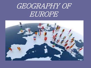
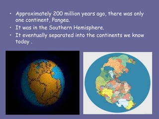
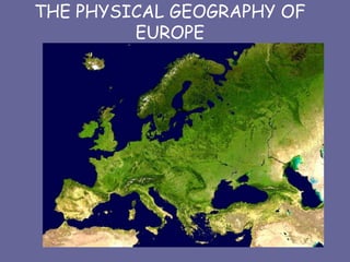
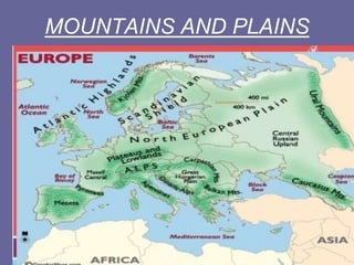
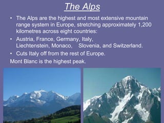
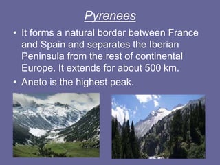
GEOGRAPHY OF
EUROPE
• Approximately 200 million years ago, there was only
one continent, Pangea.
• It was in the Southern Hemisphere.
• It eventually separated into the continents we know
today .
List of continents by population
The following table summarizes area and
population of each continent by decreasing area.
AREA AND POPULATION OF THE CONTINENTS
CONTINENT AREA (KM2) POPULATION
Asia 43,820,000
4,164,252,000
Africa 30,370,000 1,022,234,000
America 42,330,000 934,611,000
Antarctica 13,720,000 4,490
Europe 10,180,000 738,199,000
Australia 9,008,500 29,127,000
Europe
• Europe is the second smallest of the continents.
• It has the third highest population.
• It has a population of more than 730 million
which represents about 11 per cent of the world
population.
• Nowadays, there are approximately 50
countries.
THE PHYSICAL GEOGRAPHY OF
EUROPE
DISTRIBUTION OF POPULATION IN
EUROPE
EUROPEAN REGIONS
Landforms of Europe
• Europe has unique geography and weather
patterns so the landscape, waterways and
climate vary greatly.
• Europe is called a “peninsula of peninsulas”.
as it is a large peninsula of Asia.
• The landforms also include islands, plains
and mountain ranges.
There are six major peninsulas in Europe:
• Northern peninsulas: Jutland peninsula
and Scandinavian peninsula.
• Southern peninsulas: Italian peninsula,
Iberian peninsula , Balkan peninsula
and Crimean peninsula.
Which countries are covered by the
different peninsulas?
SCANDINAVIAN
PENINSULA
Norway and Sweden.
JUTLAND
PENINSULA
Denmark and the northern portion of Germany.
ITALIAN
PENINSULA
Italy, San Marino and the Vatican City.
IBERIAN
PENINSULA
Spain, Portugal, and Andorra.
BALKAN
PENINSULA
Albania, Bosnia and Herzegovina, Bulgaria
Croatia, Greece, Macedonia, Montenegro
Romania, Serbia, Kosovo, Italy*, Slovenia, Turkey
CRIMEAN
PENINSULA
Nowadays the sovereignty over the peninsula
is currently disputed between Ukraine and
the Russian Federation.
MOUNTAINS AND PLAINS
• North and east of the continent: plains and
large areas of lowlands.
• South: we find here many different
mountains.
• The most important mountain chains are:
The Scandinavian Mountains, Ural
Mountains, Pennines, Alpes, Carpathian
Mountains, Transylvanian Alps ,Massif
Central,Pyrenees, Apennines, Dinaric Alps,
Balkan Mountains, Caucasus Mountains and
The Meseta Plateau.
The Alps
• The Alps are the highest and most extensive mountain
range system in Europe, stretching approximately 1,200
kilometres across eight countries:
• Austria, France, Germany, Italy,
Liechtenstein, Monaco, Slovenia, and Switzerland.
• Cuts Italy off from the rest of Europe.
Mont Blanc is the highest peak.
Pyrenees
• It forms a natural border between France
and Spain and separates the Iberian
Peninsula from the rest of continental
Europe. It extends for about 500 km.
• Aneto is the highest peak.
The Apennine Mountains
They are a mountain range consisting of
parallel smaller chains extending 1,200 km.
They divide the Italian peninsula between
east and west.
Corno Grande is the highest point.
The Balkan Mountains
• These mountains stretch from the east
of Serbia to the Black Sea at the east
of Bulgaria.
• They extend for about 530 km .
• The highest peak is Botev.
The Caucasus Mountains
• They are a mountain system in Eurasia between
the Black Sea and the Caspian Sea
• They form a natural barrier between Europe and
Asia to the south.
• They contain Europe's highest mountain, Mount
Elbrus, 5,642 metres.
Ural Mountains ( or the Urals)
• The mountain range forms part of the
conventional boundary between the continents
of Europe and Asia.
• They extend about 2,500 km and cover Russia
and Kazakhstan.
• Mount Narodnaya is the highest point.
RIVERS
• There are many rivers in Europe and their
characteristics vary according to the ocean
or sea they flow into.
• Rivers that flow into the Artic Ocean are
long with regular course and in winter they
are frozen.
• Rivers that flow into the Atlantic Ocean
are short with high volume of water.( The
Seine and theThames).
• Rivers that flow into the Mediterranean
Sea: They are short with irregular water
flow.( Po and Rhone).
• Rivers that flow into the Caspian Sea and
Black Sea : They are long and regular
(Volga and Danube).
• There are many medium size lakes in
Central Europe, for example the Lake
Constance and Lake Geneva.
IMPORTANT RIVERS
• The Danube: It is located in Central and Eastern
Europe. It is Europe's second-longest river. It
is 2,850 km in length, and it flows through 10
countries:
Germany, Austria,Slovakia,Hungary,Croatia,
Serbia, Romania,Bulgaria, Moldova, Ukraine.
• The Rhine : It is the second-longest river in Central
and Western Europe.
• It flows through 6 countries: Switzerland,
Liechtenstein, Austria, Germany, France,
Netherlands.
• The Seine: It has 776-kilometres long river
and an important commercial waterway
within the Paris Basin in the north of
France.
• The Elbe : Rising in the Czech Republic, it
flows north through Germany, ending in
the North Sea.
• The Volga: It is he longest river in Europe
in terms of length, discharge, and
watershed. It flows through central Russia.
It's 3,692 km long.
• The Thames: This river flows through
southern England. It is the second longest
river in England and the second longest in
UK.
• It’s 346 km long.
CLIMATE IN EUROPE
• Europe has many different climates depending on the country
location within de continent.
 Polar climate: Coldest climate on Earth.Very low temperatures (-50
in winter). Flora: very restricted but we find Tundra.
 Alpine climate: ( covers the high mountains regions) Cool
temperatures in summer and very cold in winter. Heavy rain and
snow. Flora: coniferous and pine trees.
 Continental climate: (covers the Eastern Europe)
Hot summers and cold winters. Low rainfall and occasional storms in
summer. Flora: Steppes and taiga.
 Mediterranean climate: (covers Southern Europe and the area along
the Mediterranean Sea). High temperatures in summer and cool in
winter. Low precipitation but higher in autumn. Flora: evergreen
trees.
 Oceanic climate: Central and Western Europe). Mild temperatures in
summers with high precipitation all year. Flora: broadleaf forests.

EUROPE PPT.pdf

  • 1.
  • 2.
    • Approximately 200million years ago, there was only one continent, Pangea. • It was in the Southern Hemisphere. • It eventually separated into the continents we know today .
  • 3.
    List of continentsby population The following table summarizes area and population of each continent by decreasing area. AREA AND POPULATION OF THE CONTINENTS CONTINENT AREA (KM2) POPULATION Asia 43,820,000 4,164,252,000 Africa 30,370,000 1,022,234,000 America 42,330,000 934,611,000 Antarctica 13,720,000 4,490 Europe 10,180,000 738,199,000 Australia 9,008,500 29,127,000
  • 4.
    Europe • Europe isthe second smallest of the continents. • It has the third highest population. • It has a population of more than 730 million which represents about 11 per cent of the world population. • Nowadays, there are approximately 50 countries.
  • 5.
  • 6.
  • 7.
  • 8.
    Landforms of Europe •Europe has unique geography and weather patterns so the landscape, waterways and climate vary greatly. • Europe is called a “peninsula of peninsulas”. as it is a large peninsula of Asia. • The landforms also include islands, plains and mountain ranges.
  • 9.
    There are sixmajor peninsulas in Europe: • Northern peninsulas: Jutland peninsula and Scandinavian peninsula. • Southern peninsulas: Italian peninsula, Iberian peninsula , Balkan peninsula and Crimean peninsula.
  • 12.
    Which countries arecovered by the different peninsulas? SCANDINAVIAN PENINSULA Norway and Sweden. JUTLAND PENINSULA Denmark and the northern portion of Germany. ITALIAN PENINSULA Italy, San Marino and the Vatican City. IBERIAN PENINSULA Spain, Portugal, and Andorra. BALKAN PENINSULA Albania, Bosnia and Herzegovina, Bulgaria Croatia, Greece, Macedonia, Montenegro Romania, Serbia, Kosovo, Italy*, Slovenia, Turkey CRIMEAN PENINSULA Nowadays the sovereignty over the peninsula is currently disputed between Ukraine and the Russian Federation.
  • 13.
  • 14.
    • North andeast of the continent: plains and large areas of lowlands. • South: we find here many different mountains. • The most important mountain chains are: The Scandinavian Mountains, Ural Mountains, Pennines, Alpes, Carpathian Mountains, Transylvanian Alps ,Massif Central,Pyrenees, Apennines, Dinaric Alps, Balkan Mountains, Caucasus Mountains and The Meseta Plateau.
  • 15.
    The Alps • TheAlps are the highest and most extensive mountain range system in Europe, stretching approximately 1,200 kilometres across eight countries: • Austria, France, Germany, Italy, Liechtenstein, Monaco, Slovenia, and Switzerland. • Cuts Italy off from the rest of Europe. Mont Blanc is the highest peak.
  • 16.
    Pyrenees • It formsa natural border between France and Spain and separates the Iberian Peninsula from the rest of continental Europe. It extends for about 500 km. • Aneto is the highest peak.
  • 17.
    The Apennine Mountains Theyare a mountain range consisting of parallel smaller chains extending 1,200 km. They divide the Italian peninsula between east and west. Corno Grande is the highest point.
  • 18.
    The Balkan Mountains •These mountains stretch from the east of Serbia to the Black Sea at the east of Bulgaria. • They extend for about 530 km . • The highest peak is Botev.
  • 19.
    The Caucasus Mountains •They are a mountain system in Eurasia between the Black Sea and the Caspian Sea • They form a natural barrier between Europe and Asia to the south. • They contain Europe's highest mountain, Mount Elbrus, 5,642 metres.
  • 20.
    Ural Mountains (or the Urals) • The mountain range forms part of the conventional boundary between the continents of Europe and Asia. • They extend about 2,500 km and cover Russia and Kazakhstan. • Mount Narodnaya is the highest point.
  • 21.
  • 22.
    • There aremany rivers in Europe and their characteristics vary according to the ocean or sea they flow into. • Rivers that flow into the Artic Ocean are long with regular course and in winter they are frozen. • Rivers that flow into the Atlantic Ocean are short with high volume of water.( The Seine and theThames).
  • 23.
    • Rivers thatflow into the Mediterranean Sea: They are short with irregular water flow.( Po and Rhone). • Rivers that flow into the Caspian Sea and Black Sea : They are long and regular (Volga and Danube). • There are many medium size lakes in Central Europe, for example the Lake Constance and Lake Geneva.
  • 24.
    IMPORTANT RIVERS • TheDanube: It is located in Central and Eastern Europe. It is Europe's second-longest river. It is 2,850 km in length, and it flows through 10 countries: Germany, Austria,Slovakia,Hungary,Croatia, Serbia, Romania,Bulgaria, Moldova, Ukraine. • The Rhine : It is the second-longest river in Central and Western Europe. • It flows through 6 countries: Switzerland, Liechtenstein, Austria, Germany, France, Netherlands.
  • 25.
    • The Seine:It has 776-kilometres long river and an important commercial waterway within the Paris Basin in the north of France. • The Elbe : Rising in the Czech Republic, it flows north through Germany, ending in the North Sea. • The Volga: It is he longest river in Europe in terms of length, discharge, and watershed. It flows through central Russia. It's 3,692 km long.
  • 26.
    • The Thames:This river flows through southern England. It is the second longest river in England and the second longest in UK. • It’s 346 km long.
  • 28.
    CLIMATE IN EUROPE •Europe has many different climates depending on the country location within de continent.  Polar climate: Coldest climate on Earth.Very low temperatures (-50 in winter). Flora: very restricted but we find Tundra.  Alpine climate: ( covers the high mountains regions) Cool temperatures in summer and very cold in winter. Heavy rain and snow. Flora: coniferous and pine trees.  Continental climate: (covers the Eastern Europe) Hot summers and cold winters. Low rainfall and occasional storms in summer. Flora: Steppes and taiga.  Mediterranean climate: (covers Southern Europe and the area along the Mediterranean Sea). High temperatures in summer and cool in winter. Low precipitation but higher in autumn. Flora: evergreen trees.  Oceanic climate: Central and Western Europe). Mild temperatures in summers with high precipitation all year. Flora: broadleaf forests.