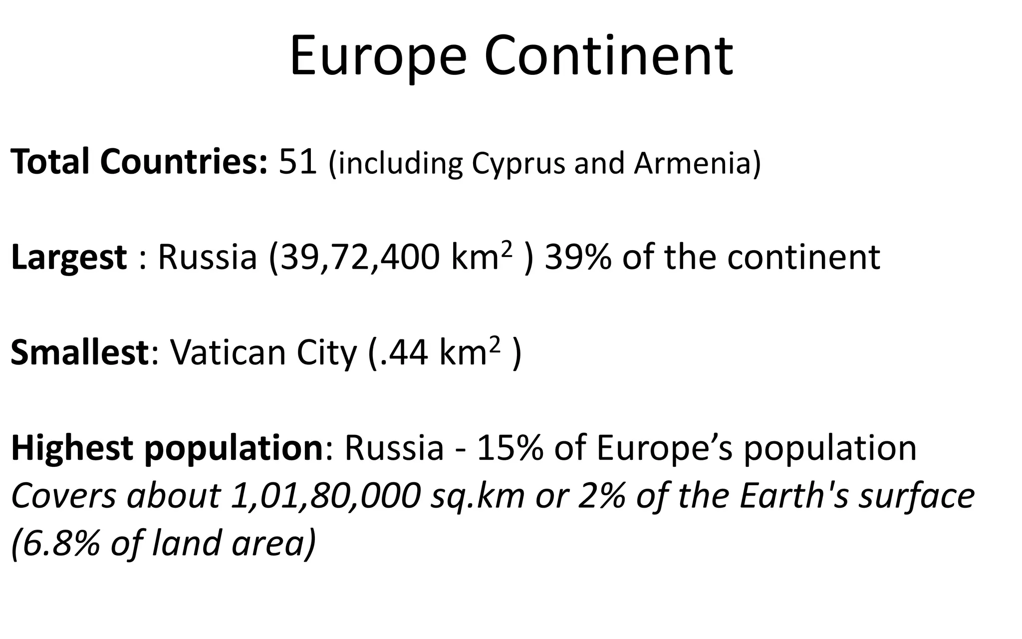
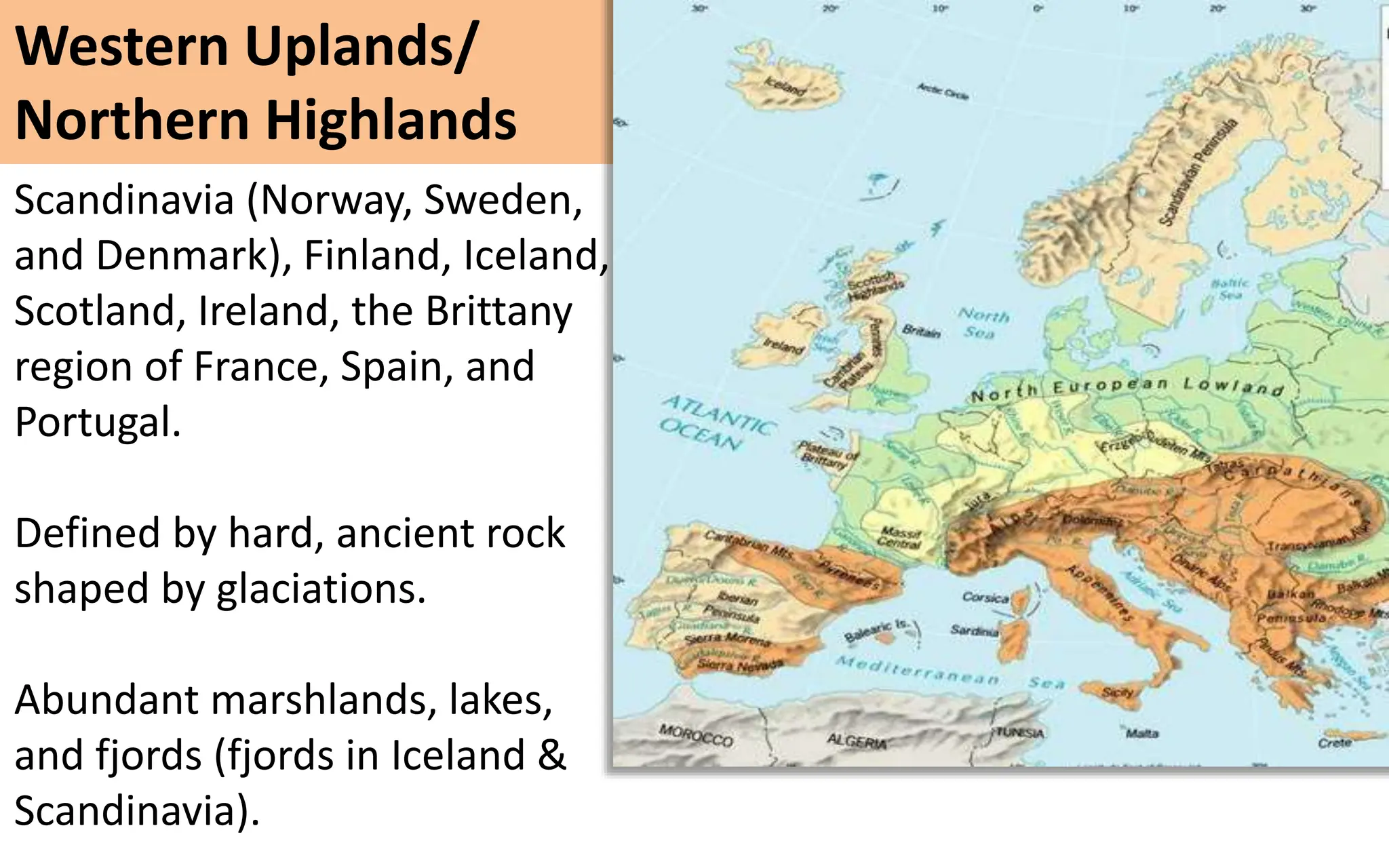
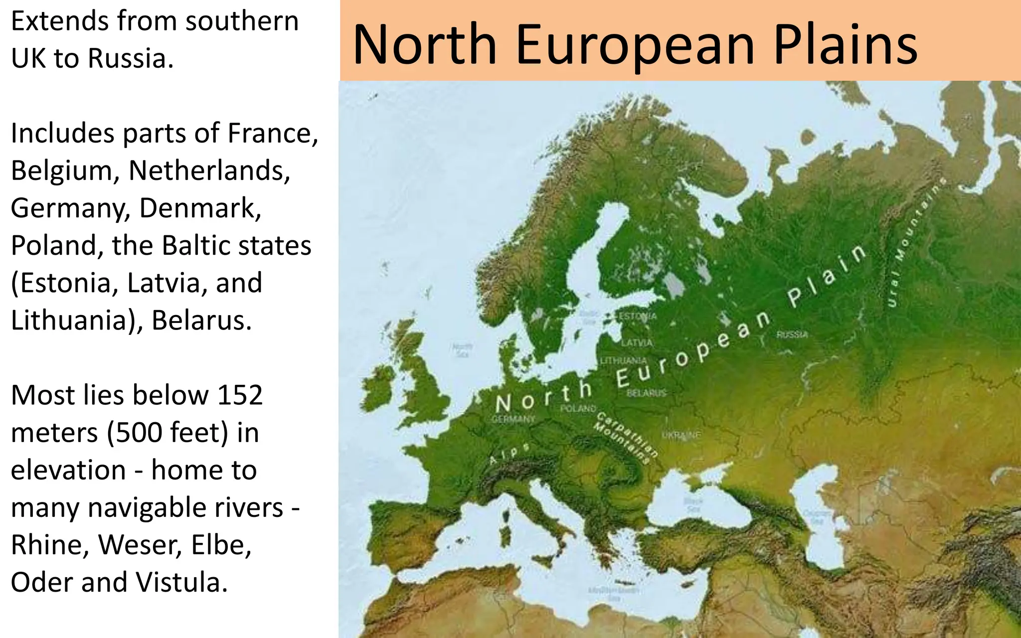
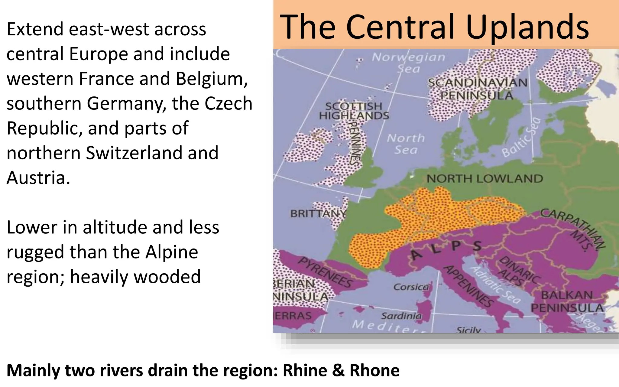
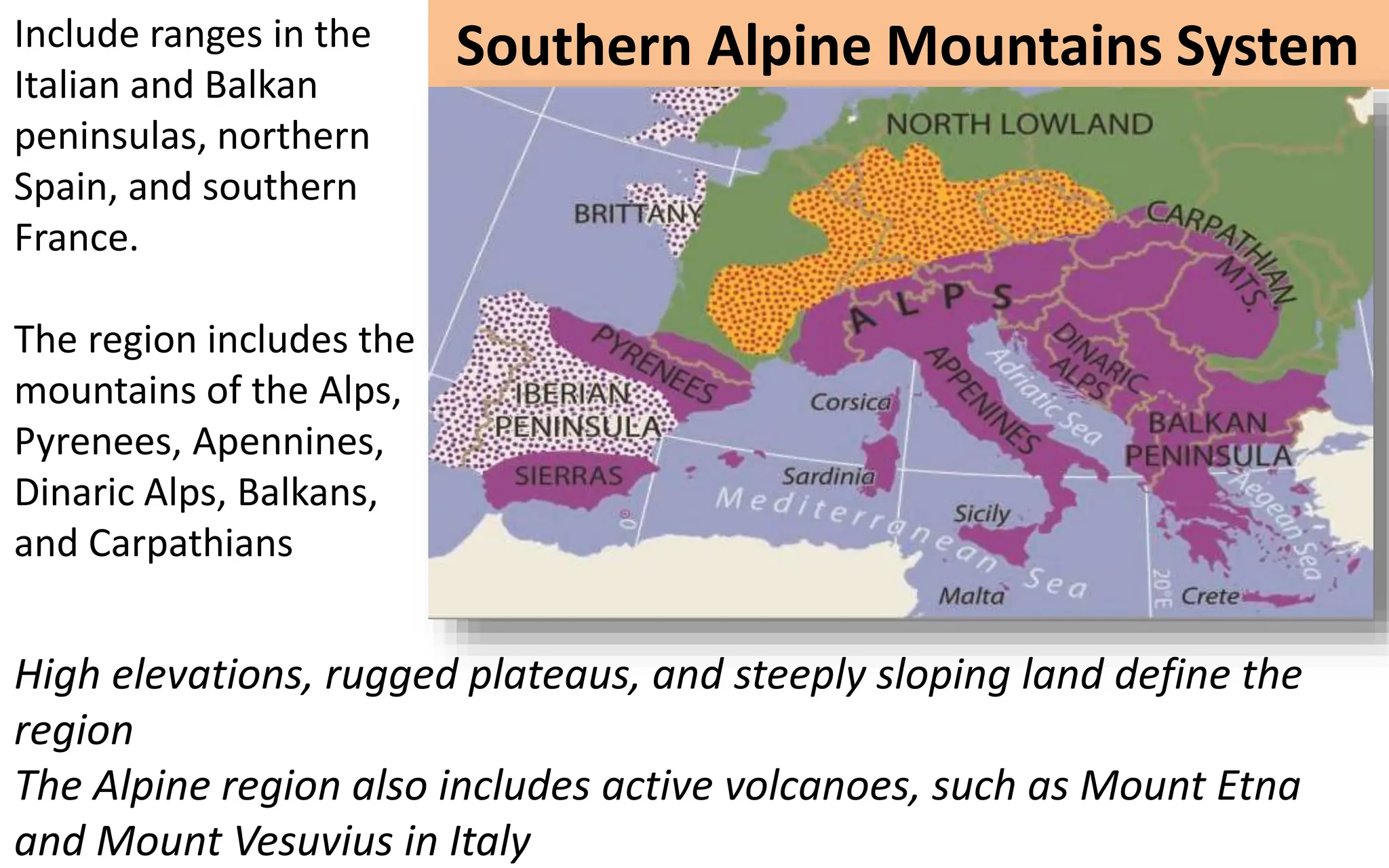
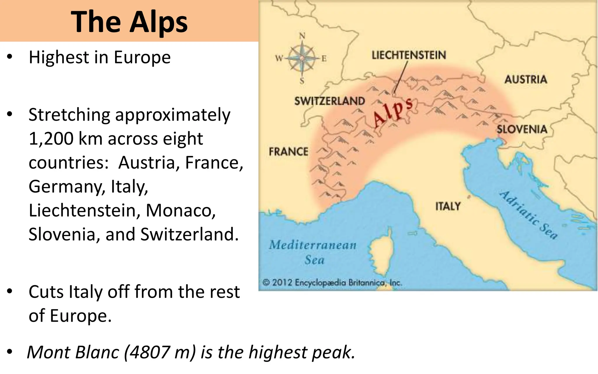
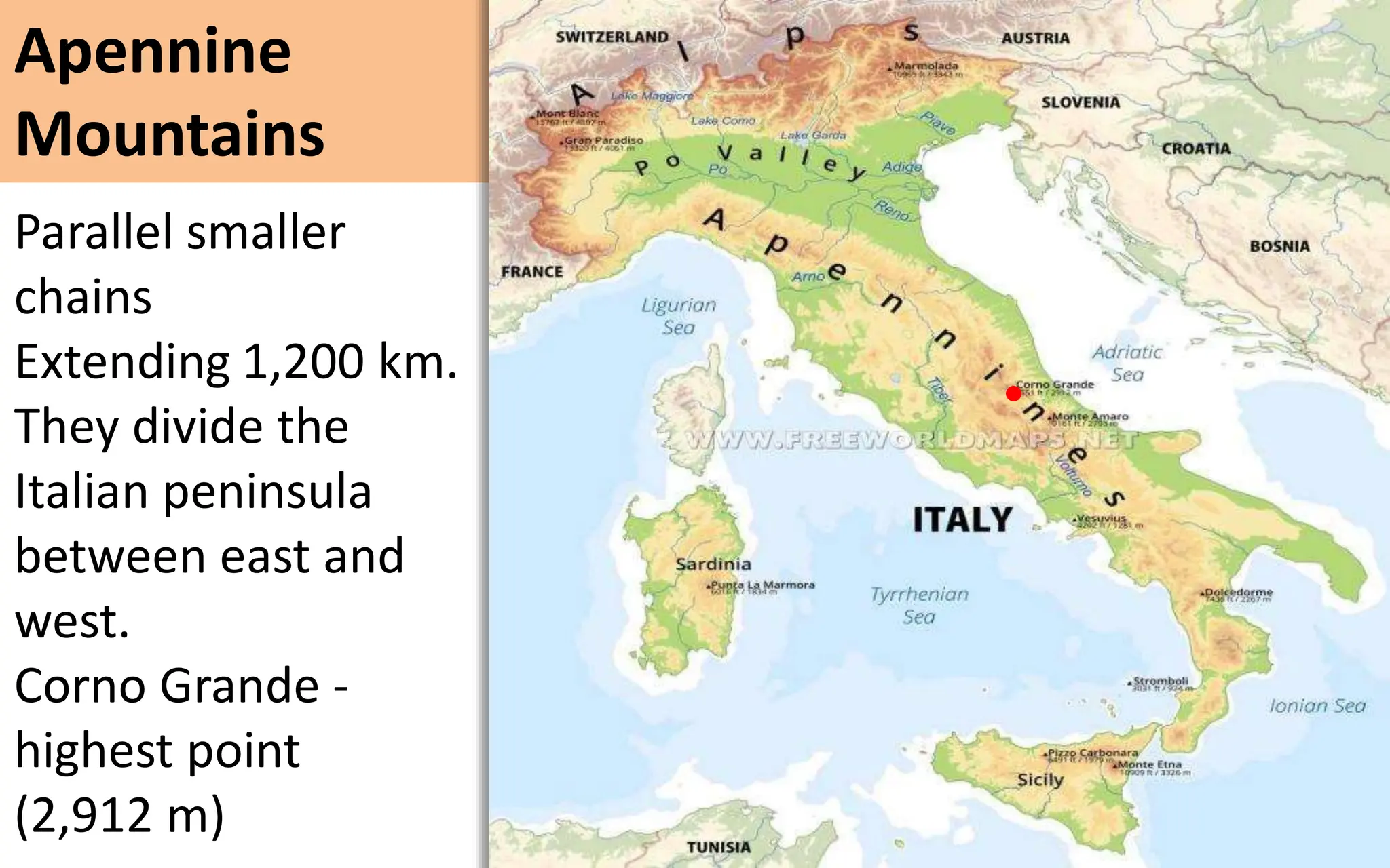
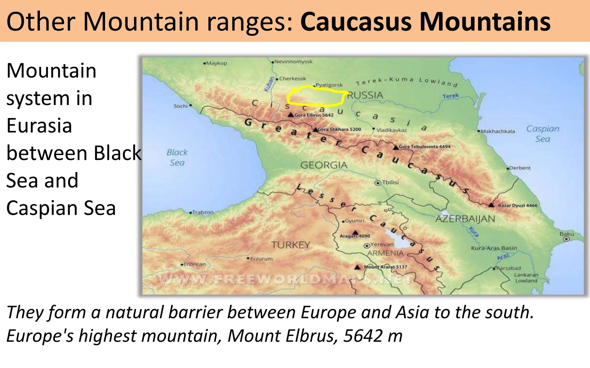
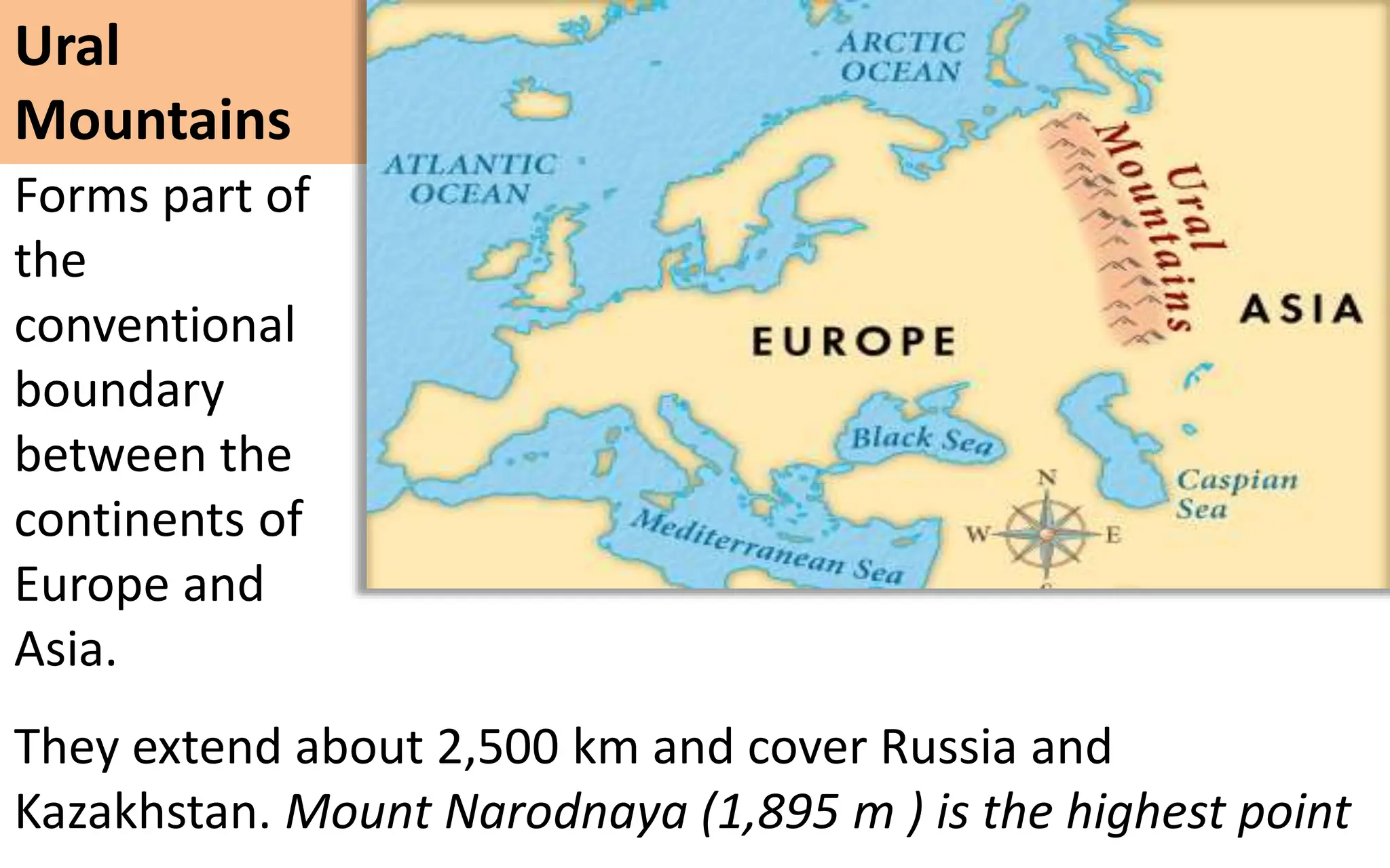
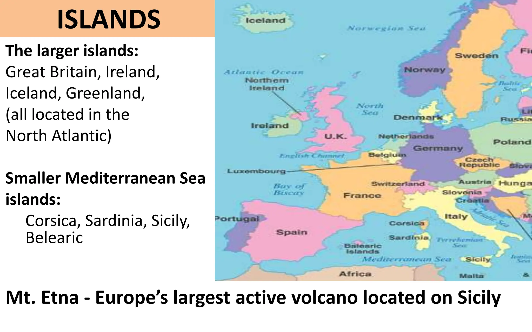
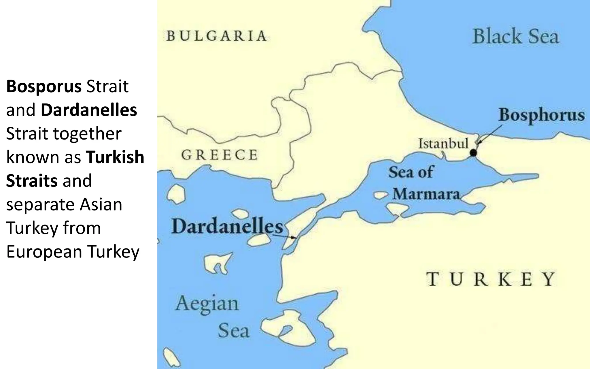
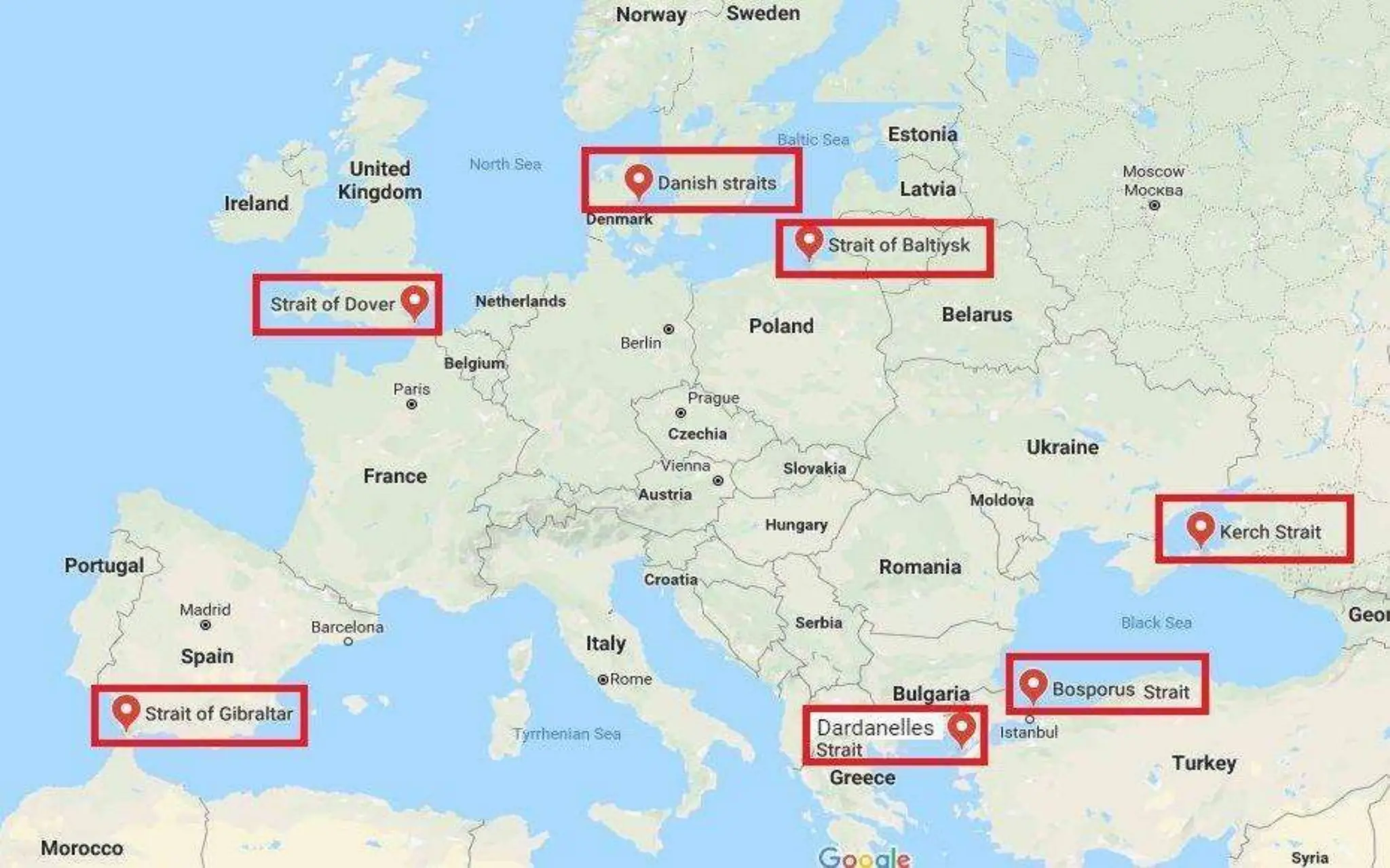
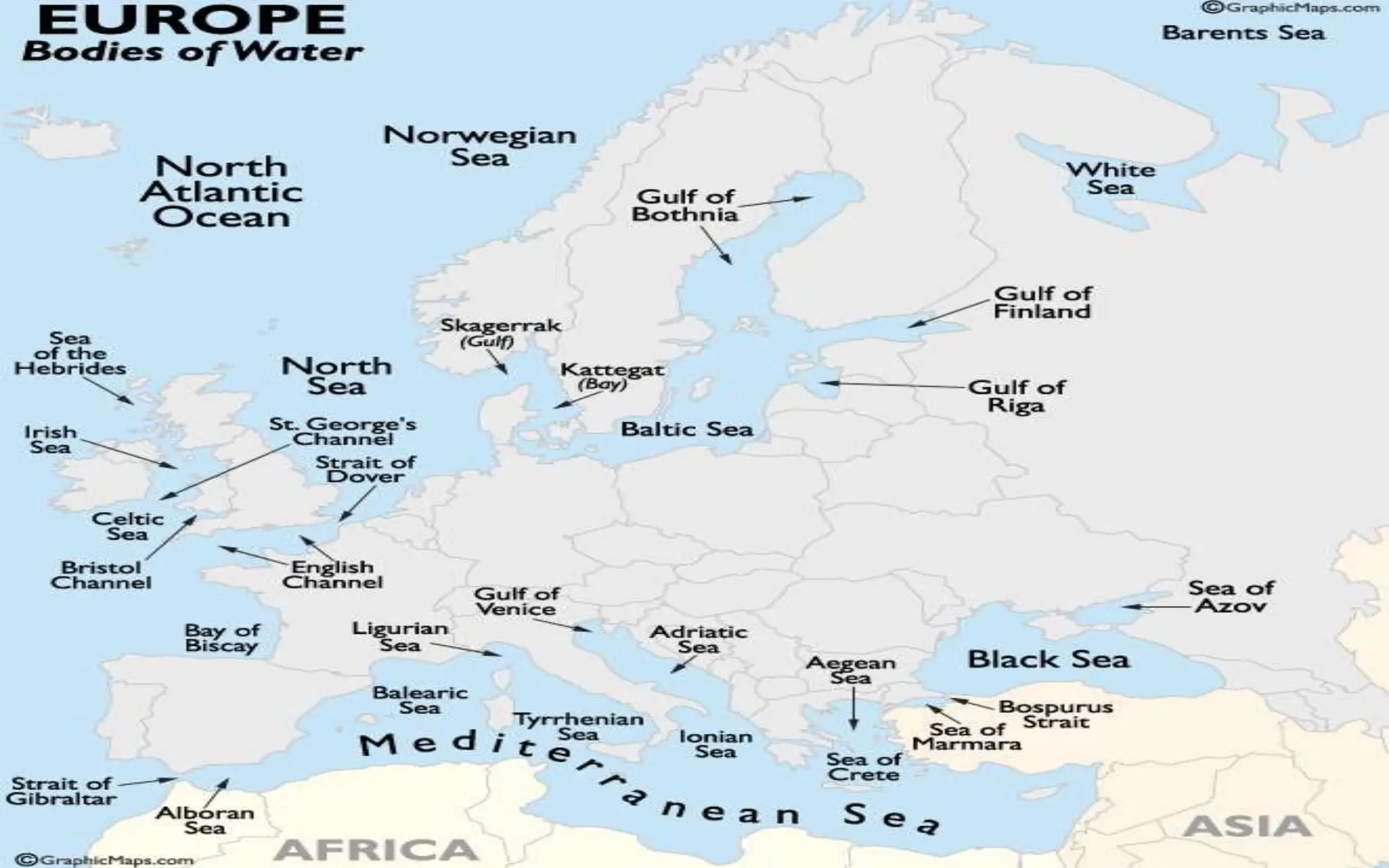
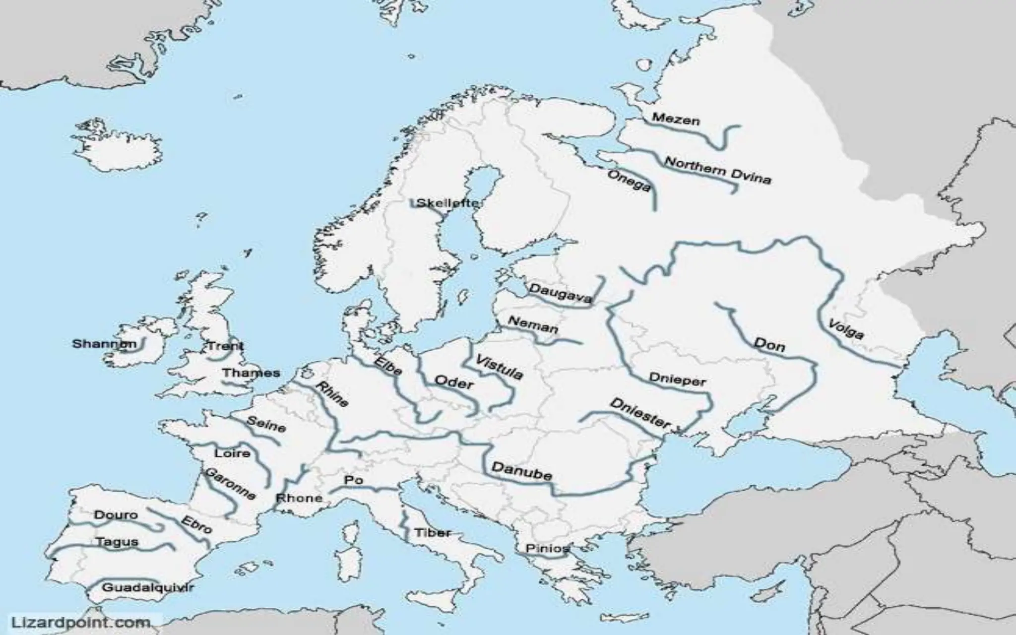
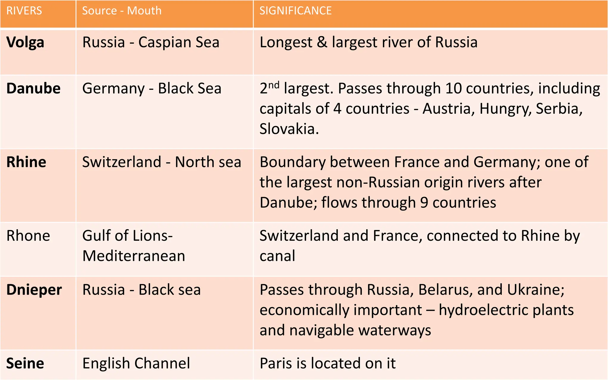
EUROPE
Physical Map
6th largest continent
Comprises westernmost part
of Eurasia
Located entirely in Northern
Hemisphere & mostly in Eastern
Hemisphere
Bounded by –
N: Arctic Ocean
W: Atlantic Ocean
S: Mediterranean Sea & Black
Sea
E: Asia
Total Countries: 51 (including Cyprus and Armenia)
Largest : Russia (39,72,400 km2 ) 39% of the continent
Smallest: Vatican City (.44 km2 )
Highest population: Russia - 15% of Europe’s population
Covers about 1,01,80,000 sq.km or 2% of the Earth's surface
(6.8% of land area)
Europe Continent
Peninsulas of Europe
6 major Peninsulas in Europe:
• Northern Peninsulas: Scandinavian and Jutland
Peninsula
• Southern Peninsulas: Iberian Peninsula, Italian
Peninsula, Balkan Peninsula and Crimean Peninsula
EUROPE - Peninsula of Peninsulas
SCANDINAVIAN
PENINSULA
• Norway
• Sweden
JUTLAND PENINSULA
• Denmark
• Northern portion of
Germany
IBERIAN
PENINSULA
• Portugal
• Spain
• Andorra
ITALIAN PENINSULA
• Italy
• San Marino
• The Vatican City
BALKAN PENINSULA
• Albania
• Bosnia and
Herzegovina
• Bulgaria
• Croatia
• Greece
• Macedonia
• Moldova
• Montenegro
• Romania
• Serbia
• Kosovo
• Slovenia
• Turkey
Sovereignty over the peninsula is currently disputed
between Ukraine and the Russian Federation.
CRIMEAN PENINSULA
PHYSICAL DIVISIONS
1. Western Uplands/Northern Highlands
2. North European Plains/ Northern Lowlands
3. Central Uplands
4. Southern Alpine Region
4 main Landforms:
Scandinavia (Norway, Sweden,
and Denmark), Finland, Iceland,
Scotland, Ireland, the Brittany
region of France, Spain, and
Portugal.
Defined by hard, ancient rock
shaped by glaciations.
Abundant marshlands, lakes,
and fjords (fjords in Iceland &
Scandinavia).
Western Uplands/
Northern Highlands
Extends from southern
UK to Russia.
Includes parts of France,
Belgium, Netherlands,
Germany, Denmark,
Poland, the Baltic states
(Estonia, Latvia, and
Lithuania), Belarus.
Most lies below 152
meters (500 feet) in
elevation - home to
many navigable rivers -
Rhine, Weser, Elbe,
Oder and Vistula.
North European Plains
Extend east-west across
central Europe and include
western France and Belgium,
southern Germany, the Czech
Republic, and parts of
northern Switzerland and
Austria.
Lower in altitude and less
rugged than the Alpine
region; heavily wooded
The Central Uplands
Mainly two rivers drain the region: Rhine & Rhone
Include ranges in the
Italian and Balkan
peninsulas, northern
Spain, and southern
France.
The region includes the
mountains of the Alps,
Pyrenees, Apennines,
Dinaric Alps, Balkans,
and Carpathians
Southern Alpine Mountains System
High elevations, rugged plateaus, and steeply sloping land define the
region
The Alpine region also includes active volcanoes, such as Mount Etna
and Mount Vesuvius in Italy
The Alps
• Highest in Europe
• Stretching approximately
1,200 km across eight
countries: Austria, France,
Germany, Italy,
Liechtenstein, Monaco,
Slovenia, and Switzerland.
• Cuts Italy off from the rest
of Europe.
• Mont Blanc (4807 m) is the highest peak.
Pyrenees
It extends for about 500 km. Aneto is the highest peak (11,168 ft)
Andorra is a tiny sovereign state in the heart of the chain
It forms a natural
border between
France and Spain
Separates the
Iberian Peninsula
from rest of Europe
Parallel smaller
chains
Extending 1,200 km.
They divide the
Italian peninsula
between east and
west.
Corno Grande -
highest point
(2,912 m)
Apennine
Mountains
The Balkan Mountains
Stretch from
east of Serbia
to the Black
Sea at the east
of Bulgaria.
They extend
for about 530
km.
Highest peak is
Mt. Olympus
(2918 m)
Mountain
system in
Eurasia
between Black
Sea and
Caspian Sea
They form a natural barrier between Europe and Asia to the south.
Europe's highest mountain, Mount Elbrus, 5642 m
Other Mountain ranges: Caucasus Mountains
Forms part of
the
conventional
boundary
between the
continents of
Europe and
Asia.
Ural
Mountains
They extend about 2,500 km and cover Russia and
Kazakhstan. Mount Narodnaya (1,895 m ) is the highest point
ISLANDS
The larger islands:
Great Britain, Ireland,
Iceland, Greenland,
(all located in the
North Atlantic)
Smaller Mediterranean Sea
islands:
Corsica, Sardinia, Sicily,
Belearic
Mt. Etna - Europe’s largest active volcano located on Sicily
SEAS of Europe
MAJOR SEAS bordering EUROPE - North
White
Sea
English Channel-
separates France and
Great Britain - South
Hampton (Britain) is main
port.
Dover Strait – shortest sea
route between England
and European Mainland,
famous for under sea
tunnel.
Kiel Canal- connects north
sea to Baltic sea
Gulf of Bothnia- northern
extension of Baltic sea
Gulf of Finland- Arm of
Baltic sea, low salinity and
important ports- Helsinki,
St. Petersburg and Tallinn
MAJOR SEAS bordering EUROPE - South
Connects Atlantic Ocean
to Mediterranean Sea
Separates the Iberian
Peninsula in Europe from
Morocco in Africa
Known as key to
Mediterranean
3 straits:
Strait of Kerch
(joins sea of
Azov and
Black sea)
Bosporus
Strait
Dardanelles
Strait
Natural strait connecting
Black Sea to Sea of
Marmara
Also known as Istanbul
Strait
Separates the European
part from the Asian
part of Istanbul
Bosporus Strait
and Dardanelles
Strait together
known as Turkish
Straits and
separate Asian
Turkey from
European Turkey
RIVERS Source - Mouth SIGNIFICANCE
Volga Russia - Caspian Sea Longest & largest river of Russia
Danube Germany - Black Sea 2nd largest. Passes through 10 countries, including
capitals of 4 countries - Austria, Hungry, Serbia,
Slovakia.
Rhine Switzerland - North sea Boundary between France and Germany; one of
the largest non-Russian origin rivers after
Danube; flows through 9 countries
Rhone Gulf of Lions-
Mediterranean
Switzerland and France, connected to Rhine by
canal
Dnieper Russia - Black sea Passes through Russia, Belarus, and Ukraine;
economically important – hydroelectric plants
and navigable waterways
Seine English Channel Paris is located on it
RIVERS DRAINS INTO SIGNIFICANCE
Po Adriatic sea Italy’s longest river
Tiber Tyrrhenian sea Rome located on it, Italy
Elbe Czech Republic -
North sea
Hamburg located on it, Germany
Weser North sea Exclusively in Germany
Oder Baltic sea Makes boundary between Germany
and Poland
Ebro Mediterranean sea Drains Spain
Vistula Poland - Baltic sea Longest & largest river of Poland.
Warsaw (capital of Poland) located
on it

Europe-Physical-Map-2.pptx details about physcial features

  • 1.
  • 2.
    6th largest continent Compriseswesternmost part of Eurasia Located entirely in Northern Hemisphere & mostly in Eastern Hemisphere Bounded by – N: Arctic Ocean W: Atlantic Ocean S: Mediterranean Sea & Black Sea E: Asia
  • 3.
    Total Countries: 51(including Cyprus and Armenia) Largest : Russia (39,72,400 km2 ) 39% of the continent Smallest: Vatican City (.44 km2 ) Highest population: Russia - 15% of Europe’s population Covers about 1,01,80,000 sq.km or 2% of the Earth's surface (6.8% of land area) Europe Continent
  • 4.
  • 5.
    6 major Peninsulasin Europe: • Northern Peninsulas: Scandinavian and Jutland Peninsula • Southern Peninsulas: Iberian Peninsula, Italian Peninsula, Balkan Peninsula and Crimean Peninsula EUROPE - Peninsula of Peninsulas
  • 7.
  • 8.
    JUTLAND PENINSULA • Denmark •Northern portion of Germany
  • 9.
  • 10.
    ITALIAN PENINSULA • Italy •San Marino • The Vatican City
  • 11.
    BALKAN PENINSULA • Albania •Bosnia and Herzegovina • Bulgaria • Croatia • Greece • Macedonia • Moldova • Montenegro • Romania • Serbia • Kosovo • Slovenia • Turkey
  • 12.
    Sovereignty over thepeninsula is currently disputed between Ukraine and the Russian Federation. CRIMEAN PENINSULA
  • 13.
  • 14.
    1. Western Uplands/NorthernHighlands 2. North European Plains/ Northern Lowlands 3. Central Uplands 4. Southern Alpine Region 4 main Landforms:
  • 16.
    Scandinavia (Norway, Sweden, andDenmark), Finland, Iceland, Scotland, Ireland, the Brittany region of France, Spain, and Portugal. Defined by hard, ancient rock shaped by glaciations. Abundant marshlands, lakes, and fjords (fjords in Iceland & Scandinavia). Western Uplands/ Northern Highlands
  • 17.
    Extends from southern UKto Russia. Includes parts of France, Belgium, Netherlands, Germany, Denmark, Poland, the Baltic states (Estonia, Latvia, and Lithuania), Belarus. Most lies below 152 meters (500 feet) in elevation - home to many navigable rivers - Rhine, Weser, Elbe, Oder and Vistula. North European Plains
  • 18.
    Extend east-west across centralEurope and include western France and Belgium, southern Germany, the Czech Republic, and parts of northern Switzerland and Austria. Lower in altitude and less rugged than the Alpine region; heavily wooded The Central Uplands Mainly two rivers drain the region: Rhine & Rhone
  • 19.
    Include ranges inthe Italian and Balkan peninsulas, northern Spain, and southern France. The region includes the mountains of the Alps, Pyrenees, Apennines, Dinaric Alps, Balkans, and Carpathians Southern Alpine Mountains System High elevations, rugged plateaus, and steeply sloping land define the region The Alpine region also includes active volcanoes, such as Mount Etna and Mount Vesuvius in Italy
  • 20.
    The Alps • Highestin Europe • Stretching approximately 1,200 km across eight countries: Austria, France, Germany, Italy, Liechtenstein, Monaco, Slovenia, and Switzerland. • Cuts Italy off from the rest of Europe. • Mont Blanc (4807 m) is the highest peak.
  • 21.
    Pyrenees It extends forabout 500 km. Aneto is the highest peak (11,168 ft) Andorra is a tiny sovereign state in the heart of the chain It forms a natural border between France and Spain Separates the Iberian Peninsula from rest of Europe
  • 22.
    Parallel smaller chains Extending 1,200km. They divide the Italian peninsula between east and west. Corno Grande - highest point (2,912 m) Apennine Mountains
  • 23.
    The Balkan Mountains Stretchfrom east of Serbia to the Black Sea at the east of Bulgaria. They extend for about 530 km. Highest peak is Mt. Olympus (2918 m)
  • 24.
    Mountain system in Eurasia between Black Seaand Caspian Sea They form a natural barrier between Europe and Asia to the south. Europe's highest mountain, Mount Elbrus, 5642 m Other Mountain ranges: Caucasus Mountains
  • 25.
    Forms part of the conventional boundary betweenthe continents of Europe and Asia. Ural Mountains They extend about 2,500 km and cover Russia and Kazakhstan. Mount Narodnaya (1,895 m ) is the highest point
  • 26.
    ISLANDS The larger islands: GreatBritain, Ireland, Iceland, Greenland, (all located in the North Atlantic) Smaller Mediterranean Sea islands: Corsica, Sardinia, Sicily, Belearic Mt. Etna - Europe’s largest active volcano located on Sicily
  • 27.
  • 28.
    MAJOR SEAS borderingEUROPE - North White Sea
  • 29.
    English Channel- separates Franceand Great Britain - South Hampton (Britain) is main port. Dover Strait – shortest sea route between England and European Mainland, famous for under sea tunnel. Kiel Canal- connects north sea to Baltic sea
  • 30.
    Gulf of Bothnia-northern extension of Baltic sea Gulf of Finland- Arm of Baltic sea, low salinity and important ports- Helsinki, St. Petersburg and Tallinn
  • 31.
    MAJOR SEAS borderingEUROPE - South
  • 33.
    Connects Atlantic Ocean toMediterranean Sea Separates the Iberian Peninsula in Europe from Morocco in Africa Known as key to Mediterranean
  • 34.
    3 straits: Strait ofKerch (joins sea of Azov and Black sea) Bosporus Strait Dardanelles Strait
  • 35.
    Natural strait connecting BlackSea to Sea of Marmara Also known as Istanbul Strait Separates the European part from the Asian part of Istanbul
  • 36.
    Bosporus Strait and Dardanelles Straittogether known as Turkish Straits and separate Asian Turkey from European Turkey
  • 40.
    RIVERS Source -Mouth SIGNIFICANCE Volga Russia - Caspian Sea Longest & largest river of Russia Danube Germany - Black Sea 2nd largest. Passes through 10 countries, including capitals of 4 countries - Austria, Hungry, Serbia, Slovakia. Rhine Switzerland - North sea Boundary between France and Germany; one of the largest non-Russian origin rivers after Danube; flows through 9 countries Rhone Gulf of Lions- Mediterranean Switzerland and France, connected to Rhine by canal Dnieper Russia - Black sea Passes through Russia, Belarus, and Ukraine; economically important – hydroelectric plants and navigable waterways Seine English Channel Paris is located on it
  • 41.
    RIVERS DRAINS INTOSIGNIFICANCE Po Adriatic sea Italy’s longest river Tiber Tyrrhenian sea Rome located on it, Italy Elbe Czech Republic - North sea Hamburg located on it, Germany Weser North sea Exclusively in Germany Oder Baltic sea Makes boundary between Germany and Poland Ebro Mediterranean sea Drains Spain Vistula Poland - Baltic sea Longest & largest river of Poland. Warsaw (capital of Poland) located on it

Editor's Notes

  • #17 Glaciation is the process of land being transformed by glaciers or ice sheets. As glaciers receded from the area, they left a number of distinct physical features, including abundant marshlands, lakes, and fjords. A fjord is a long and narrow inlet of the sea that is surrounded by high, rugged cliffs.
  • #18 The North European Plain extends from the southern United Kingdom east to Russia. It includes parts of France, Belgium, the Netherlands, Germany, Denmark, Poland, the Baltic states (Estonia, Latvia, and Lithuania), and Belarus.