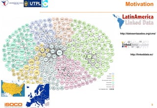
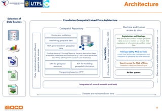
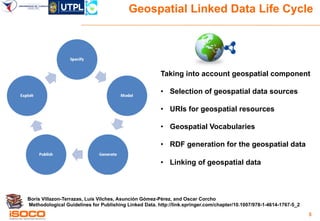
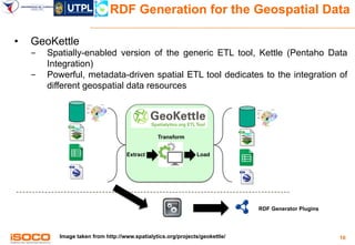
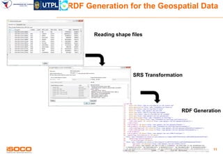
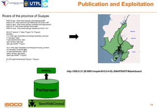
KDrive

Ecuadorian Geospatial Linked Data
Victor Saquicela1, Mauricio Espinoza1,
Nelson Piedra2, and Boris Villazón-Terrazas3
Universidad de Cuenca, Ecuador
{victor.saquicela,mauricio.espinoza}@ucuenca.edu.ec
2 Universidad Técnica Particular de Loja, Ecuador
nopiedra@utpl.edu.ec
3 Intelligent Software Components, iSOCO
bvillazon@isoco.com
@boricles
http://www.slideshare.net/boricles
1
ToC
» Motivation
» Architecture
» Geospatial Linked Data Life Cycle

2
Motivation

http://datosenlazados.org/cms/

http://linkeddata.ec/

3
Architecture

4
Geospatial Linked Data Life Cycle

Taking into account geospatial component
•  Selection of geospatial data sources
•  URIs for geospatial resources
•  Geospatial Vocabularies
•  RDF generation for the geospatial data
•  Linking of geospatial data

Boris Villazon-Terrazas, Luis Vilches, Asunción Gómez-Pérez, and Oscar Corcho
Methodological Guidelines for Publishing Linked Data. http://link.springer.com/chapter/10.1007/978-1-4614-1767-5_2
5
Selection of the data sources
•  Identify and select geospatial resources from Ecuadorian Government Agencies.
•  Geo-databases
•  Shapefiles
•  Spreadsheets
•  KML

6
URIs for Geospatial Resources

• 

General guidelines

- 
- 
- 
- 
- 

• 

BP for publishing LD http://www.w3.org/TR/ld-bp/
URIs for UK Public sector
https://www.gov.uk/government/publications/designing-uri-sets-for-the-uk-public-sector
Study of persistent URIs http://philarcher.org/diary/2013/uripersistence/
Guidelines for Naming and Labeling Ontologies
http://dcevents.dublincore.org/IntConf/dc-2011/paper/download/47/15
….

Geospatial specific guidelines
- 
- 
- 
- 
- 

RFC5870 URI for geospatial locations http://tools.ietf.org/search/rfc5870
INSPIRE http://inspire.jrc.ec.europa.eu/events/conferences/inspire_2012/presentations/ds1/
Clements%20Portele.pdf
https://www.deri.ie/content/applying-design-patterns-uri-strategies-naming-linked-geospatialdata-infrastructure
http://inspire-forum.jrc.ec.europa.eu/pg/forum/topic/29922/cool-uris-for-linked-geospatialdata/
…
7
Geospatial Vocabularies
• 

NeoGeo

http://geovocab.org/doc/neogeo/

• 

GeoSPARQL

http://www.opengeospatial.org/standards/geosparql

• 

ISA Programme Location Core Vocabulary

• 

schema.org

http://schema.org/

- 
- 
- 

http://schema.org/Place
http://schema.org/GeoShape
http://schema.org/GeoCoordinates

• 

Place
GeoShape
GeoCoordinates

http://www.w3.org/ns/locn

ISO-19115 Ontology
https://www.seegrid.csiro.au/subversion/xmml/metadata/ISO19115/iso-19115.owl

…

8
Geospatial Vocabularies

• 

Some discussions
- 

Geometry separated from the feature

- 

Represent geometry as RDF Literal

- 

Represent CRS as a property.

- 

URIs for the CRSs, e.g.,
http://geovocab.org/crs/EPSG4979

- 

Multilinguality

9
RDF Generation for the Geospatial Data
• 

GeoKettle

- 
- 

Spatially-enabled version of the generic ETL tool, Kettle (Pentaho Data
Integration)
Powerful, metadata-driven spatial ETL tool dedicates to the integration of
different geospatial data resources

Transform
Extract

Load

RDF Generator Plugins

Image taken from http://www.spatialytics.org/projects/geokettle/

10
RDF Generation for the Geospatial Data

Reading shape files

SRS Transformation

RDF Generation

11
Linking of Geospatial Data

‪http://wifo5-03.informatik.uni-mannheim.de/bizer/silk/

12
Publication and Exploitation
Rivers of the province of Guayas
PREFIX geo: <http://www.opengis.net/ont/geosparql#>
PREFIX rdf: <http://www.w3.org/1999/02/22-rdf-syntax-ns#>
PREFIX geof: <http://www.opengis.net/def/function/geosparql/>
PREFIX sf: <http://www.opengis.net/ont/sf#>
PREFIX units: <http://www.opengis.net/def/uom/OGC/1.0/>
SELECT distinct ?r ?label ?Figure ?r2 ?Figure2
WHERE {
?r rdf:type <http://geo.linkeddata.ec/ontology/riosdobles_promsa>.
?r rdfs:label ?label.
?r geo:hasGeometry ?geo.
?geo rdf:type ?geoType .
?geo geo:asWKT ?Figure.

http://purl.org/Ecuador/geo/sparql
SPARQL

?r2 rdf:type <http://geo.linkeddata.ec/ontology/provincias_promsa>.
?r2 rdfs:label "GUAYAS"@es.
?r2 geo:hasGeometry ?geo2.
?geo2 rdf:type ?geoType2 .
?geo2 geo:asWKT ?Figure2.
FILTER (geof:sfIntersects(?Figure2, ?Figure)).
}

Parliament

13
Publication and Exploitation
Rivers of the province of Guayas
PREFIX geo: <http://www.opengis.net/ont/geosparql#>
PREFIX rdf: <http://www.w3.org/1999/02/22-rdf-syntax-ns#>
PREFIX geof: <http://www.opengis.net/def/function/geosparql/>
PREFIX sf: <http://www.opengis.net/ont/sf#>
PREFIX units: <http://www.opengis.net/def/uom/OGC/1.0/>
SELECT distinct ?r ?label ?Figure ?r2 ?Figure2
WHERE {
?r a <http://geo.linkeddata.ec/ontology/riosdobles_promsa>.
?r rdfs:label ?label.
?r geo:hasGeometry ?geo.
?geo rdf:type ?geoType .
?geo geo:asWKT ?Figure.
?r2 a <http://geo.linkeddata.ec/ontology/provincias_promsa>.
?r2 rdfs:label "GUAYAS"@es.
?r2 geo:hasGeometry ?geo2.
?geo2 rdf:type ?geoType2 .
?geo2 geo:asWKT ?Figure2.
FILTER (geof:sfIntersects(?Figure2, ?Figure)).
}

SPARQL

http://200.0.31.28:8081/map4rdf-0.0.4-OL-SNAPSHOT/#dashboard

Parliament

14
15
KDrive

Ecuadorian Geospatial Linked Data
Victor Saquicela1, Mauricio Espinoza1,
Nelson Piedra2, and Boris Villazón-Terrazas3
Universidad de Cuenca, Ecuador
{victor.saquicela,mauricio.espinoza}@ucuenca.edu.ec
2 Universidad Técnica Particular de Loja, Ecuador
nopiedra@utpl.edu.ec
3 Intelligent Software Components, iSOCO
bvillazon@isoco.com
@boricles
http://www.slideshare.net/boricles
1

Ecuadorian Geospatial Linked Data

  • 1.
    KDrive Ecuadorian Geospatial LinkedData Victor Saquicela1, Mauricio Espinoza1, Nelson Piedra2, and Boris Villazón-Terrazas3 Universidad de Cuenca, Ecuador {victor.saquicela,mauricio.espinoza}@ucuenca.edu.ec 2 Universidad Técnica Particular de Loja, Ecuador nopiedra@utpl.edu.ec 3 Intelligent Software Components, iSOCO bvillazon@isoco.com @boricles http://www.slideshare.net/boricles 1
  • 2.
  • 3.
  • 4.
  • 5.
    Geospatial Linked DataLife Cycle Taking into account geospatial component •  Selection of geospatial data sources •  URIs for geospatial resources •  Geospatial Vocabularies •  RDF generation for the geospatial data •  Linking of geospatial data Boris Villazon-Terrazas, Luis Vilches, Asunción Gómez-Pérez, and Oscar Corcho Methodological Guidelines for Publishing Linked Data. http://link.springer.com/chapter/10.1007/978-1-4614-1767-5_2 5
  • 6.
    Selection of thedata sources •  Identify and select geospatial resources from Ecuadorian Government Agencies. •  Geo-databases •  Shapefiles •  Spreadsheets •  KML 6
  • 7.
    URIs for GeospatialResources •  General guidelines -  -  -  -  -  •  BP for publishing LD http://www.w3.org/TR/ld-bp/ URIs for UK Public sector https://www.gov.uk/government/publications/designing-uri-sets-for-the-uk-public-sector Study of persistent URIs http://philarcher.org/diary/2013/uripersistence/ Guidelines for Naming and Labeling Ontologies http://dcevents.dublincore.org/IntConf/dc-2011/paper/download/47/15 …. Geospatial specific guidelines -  -  -  -  -  RFC5870 URI for geospatial locations http://tools.ietf.org/search/rfc5870 INSPIRE http://inspire.jrc.ec.europa.eu/events/conferences/inspire_2012/presentations/ds1/ Clements%20Portele.pdf https://www.deri.ie/content/applying-design-patterns-uri-strategies-naming-linked-geospatialdata-infrastructure http://inspire-forum.jrc.ec.europa.eu/pg/forum/topic/29922/cool-uris-for-linked-geospatialdata/ … 7
  • 8.
    Geospatial Vocabularies •  NeoGeo http://geovocab.org/doc/neogeo/ •  GeoSPARQL http://www.opengeospatial.org/standards/geosparql •  ISA ProgrammeLocation Core Vocabulary •  schema.org http://schema.org/ -  -  -  http://schema.org/Place http://schema.org/GeoShape http://schema.org/GeoCoordinates •  Place GeoShape GeoCoordinates http://www.w3.org/ns/locn ISO-19115 Ontology https://www.seegrid.csiro.au/subversion/xmml/metadata/ISO19115/iso-19115.owl … 8
  • 9.
    Geospatial Vocabularies •  Some discussions -  Geometryseparated from the feature -  Represent geometry as RDF Literal -  Represent CRS as a property. -  URIs for the CRSs, e.g., http://geovocab.org/crs/EPSG4979 -  Multilinguality 9
  • 10.
    RDF Generation forthe Geospatial Data •  GeoKettle -  -  Spatially-enabled version of the generic ETL tool, Kettle (Pentaho Data Integration) Powerful, metadata-driven spatial ETL tool dedicates to the integration of different geospatial data resources Transform Extract Load RDF Generator Plugins Image taken from http://www.spatialytics.org/projects/geokettle/ 10
  • 11.
    RDF Generation forthe Geospatial Data Reading shape files SRS Transformation RDF Generation 11
  • 12.
    Linking of GeospatialData ‪http://wifo5-03.informatik.uni-mannheim.de/bizer/silk/ 12
  • 13.
    Publication and Exploitation Riversof the province of Guayas PREFIX geo: <http://www.opengis.net/ont/geosparql#> PREFIX rdf: <http://www.w3.org/1999/02/22-rdf-syntax-ns#> PREFIX geof: <http://www.opengis.net/def/function/geosparql/> PREFIX sf: <http://www.opengis.net/ont/sf#> PREFIX units: <http://www.opengis.net/def/uom/OGC/1.0/> SELECT distinct ?r ?label ?Figure ?r2 ?Figure2 WHERE { ?r rdf:type <http://geo.linkeddata.ec/ontology/riosdobles_promsa>. ?r rdfs:label ?label. ?r geo:hasGeometry ?geo. ?geo rdf:type ?geoType . ?geo geo:asWKT ?Figure. http://purl.org/Ecuador/geo/sparql SPARQL ?r2 rdf:type <http://geo.linkeddata.ec/ontology/provincias_promsa>. ?r2 rdfs:label "GUAYAS"@es. ?r2 geo:hasGeometry ?geo2. ?geo2 rdf:type ?geoType2 . ?geo2 geo:asWKT ?Figure2. FILTER (geof:sfIntersects(?Figure2, ?Figure)). } Parliament 13
  • 14.
    Publication and Exploitation Riversof the province of Guayas PREFIX geo: <http://www.opengis.net/ont/geosparql#> PREFIX rdf: <http://www.w3.org/1999/02/22-rdf-syntax-ns#> PREFIX geof: <http://www.opengis.net/def/function/geosparql/> PREFIX sf: <http://www.opengis.net/ont/sf#> PREFIX units: <http://www.opengis.net/def/uom/OGC/1.0/> SELECT distinct ?r ?label ?Figure ?r2 ?Figure2 WHERE { ?r a <http://geo.linkeddata.ec/ontology/riosdobles_promsa>. ?r rdfs:label ?label. ?r geo:hasGeometry ?geo. ?geo rdf:type ?geoType . ?geo geo:asWKT ?Figure. ?r2 a <http://geo.linkeddata.ec/ontology/provincias_promsa>. ?r2 rdfs:label "GUAYAS"@es. ?r2 geo:hasGeometry ?geo2. ?geo2 rdf:type ?geoType2 . ?geo2 geo:asWKT ?Figure2. FILTER (geof:sfIntersects(?Figure2, ?Figure)). } SPARQL http://200.0.31.28:8081/map4rdf-0.0.4-OL-SNAPSHOT/#dashboard Parliament 14
  • 15.
  • 16.
    KDrive Ecuadorian Geospatial LinkedData Victor Saquicela1, Mauricio Espinoza1, Nelson Piedra2, and Boris Villazón-Terrazas3 Universidad de Cuenca, Ecuador {victor.saquicela,mauricio.espinoza}@ucuenca.edu.ec 2 Universidad Técnica Particular de Loja, Ecuador nopiedra@utpl.edu.ec 3 Intelligent Software Components, iSOCO bvillazon@isoco.com @boricles http://www.slideshare.net/boricles 1