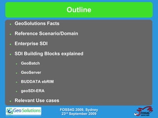
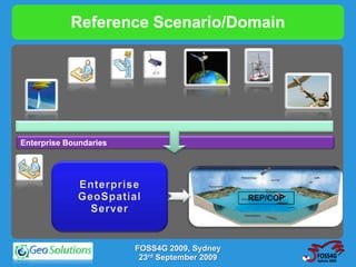
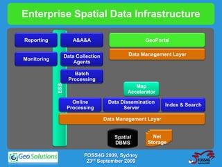
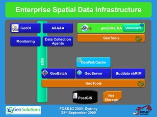
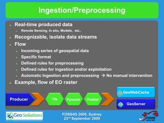
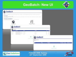
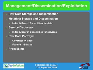
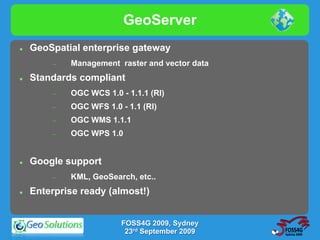
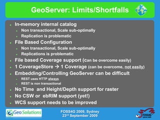
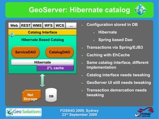
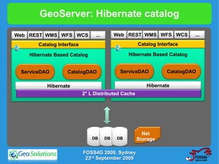
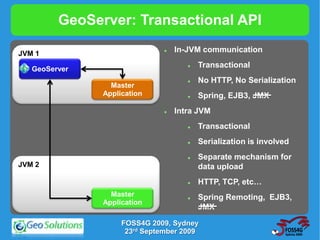
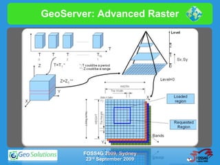
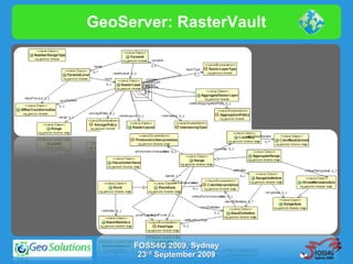
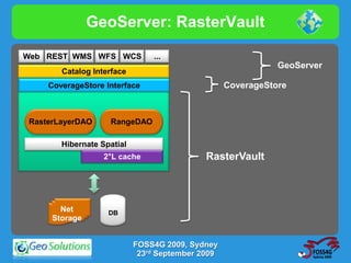
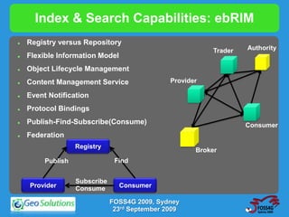
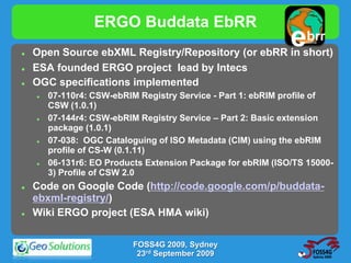
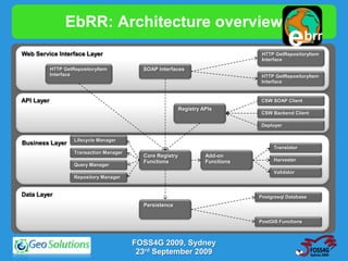
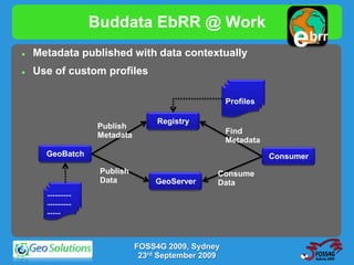
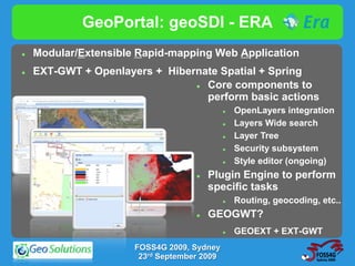
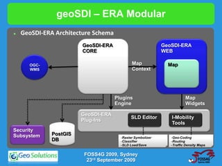
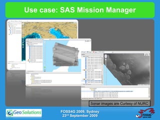
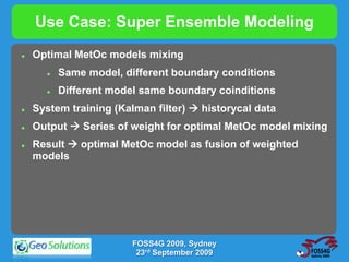
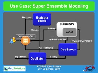
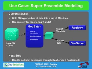
GeoServer, GeoTools and GeoBatch:
      supporting operational
  Meteorology and Oceanography

       Ing Simone Giannecchini


            FOSS4G 2009, Sydney
             23rd September 2009
Outline
   GeoSolutions Facts

   Reference Scenario/Domain

   Enterprise SDI

   SDI Building Blocks explained
       GeoBatch

       GeoServer

       BUDDATA ebRIM

       geoSDI-ERA

   Relevant Use cases
                         FOSS4G 2009, Sydney
                          23rd September 2009
GeoSolutions - Facts
   Funded mid 2006 in Italy
   Staff of 7 engineers (2 consultants)
   Expertise
           Image Processing, GeoSpatial Data Fusion
           Java, Java Enterprise, C++, Python
           JPEG2000, JPIP, Advanced 2D visualization
   Supporting/Developing FOSS4G projects
       GeoTools, GeoServer, GeoBatch, ImageIO-Ext, uDig
   Focus on
       Consultancy (agencies, large private companies, etc…)
       Building stack of geospatial Open Source products

                            FOSS4G 2009, Sydney
                             23rd September 2009
Reference Scenario/Domain


Enterprise Boundaries


                                               REP/COP


                        FOSS4G 2009, Sydney
                         23rd September 2009
Enterprise Spatial Data Infrastructure

Reporting             A&A&A                          GeoPortal


                   Data Collection            Data Management Layer
Monitoring
                       Agents

                      Batch
                    Processing
             ESB


                                                 Map
                                              Accelerator

                      Online          Data Dissemination
                                                             Index & Search
                    Processing              Server

                                     Data Management Layer


                                         Spatial        Net
                                         DBMS         Storage

                           FOSS4G 2009, Sydney
                            23rd September 2009
Enterprise Spatial Data Infrastructure

  GeoBI               A&A&A                       geoSDI-ERA   OpenLayers


                   Data Collection                  GeoTools
Monitoring   ESB       Agents


                                      GeoWebCache


                     GeoBatch           GeoServer         Buddata ebRIM

                                        GeoTools


                                                      Net
                                     PostGIS        Storage

                           FOSS4G 2009, Sydney
                            23rd September 2009
Ingestion/Preprocessing
   Real-time produced data
       Remote Sensing, In situ, Models, etc..

   Recognizable, isolate data streams
   Flow
       Incoming series of geospatial data
       Specific format
       Defined rules for preprocessing
       Defined rules for ingestion and/or exploitation
       Automatic Ingestion and preprocessing  No manual intervention
   Example, flow of EO raster
                                                           GeoWebCache
Producer                   Tile     Pyramid      Publish
                                                            GeoServer

                                  FOSS4G 2009, Sydney
                                   23rd September 2009
GeoBatch: Basics
   Event-based geospatial-aware batch ingestion/processing
    system
   Basic tools for automatic collection, processing and
    publication of data.
   Open Source (leverages on GeoTools, Apache FTP, Spring,
    Xstream, etc…)
   Embedded FTP Server
   Publish to GeoServer
   Publish to GeoWebCache (ongoing)
   Web based
   XML configuration
   http://docs.codehaus.org/display/GEOBATCH
                         FOSS4G 2009, Sydney
                          23rd September 2009
GeoBatch:FlowManager

                    FileSystemMonitor


Directory


                                                          Mailbox
                                                           Event
Monitoring
         Action


                     Action


                                Action


                                                     EventDispatcher


                                                   Event              Event
                                                 Consumer           Consumer
FlowManager

                              FOSS4G 2009, Sydney
                               23rd September 2009
GeoBatch:Sample Flow
 - <FlowConfiguration>
      <workingDirectory>AISAnomalies</workingDirectory>
      <autorun>true</autorun>
-     <EventConsumerConfiguration>
           <workingDirectory>AISAnomalies</workingDirectory>
           <performBackup>true</performBackup>
-          <FileEventRule>
                 <optional>false</optional>
                 <originalOccurrencies>1</originalOccurrencies>
                 <regex>.*.shp</regex>
                 <id>r1</id>
                 <description>description</description>
                 <name>test</name>
           </FileEventRule>
….
-          <GeoServerActionConfiguration>
                 <crs>EPSG:4326</crs>
                 <envelope />
                 <dataTransferMethod>URL</dataTransferMethod>
                 <geoserverPWD>geoserver</geoserverPWD>
                 <geoserverUID>admin</geoserverUID>
                 <geoserverURL>http://localhost:8080/geoserver</geoserverURL>
                 <wmsPath>/</wmsPath>
                 <defaultStyle>polygon</defaultStyle>
                 <styles />
           </GeoServerActionConfiguration>


                                      FOSS4G 2009, Sydney
                                       23rd September 2009
GeoBatch:Sample Flow
-              <GeoServerActionConfiguration>
                    <crs>EPSG:4326</crs>
                    <envelope />
                    <dataTransferMethod>URL</dataTransferMethod>
                    <geoserverPWD>geoserver</geoserverPWD>
                    <geoserverUID>admin</geoserverUID>
                    <geoserverURL>http://localhost:8080/geoserver</geoserverURL>
                    <wmsPath>/</wmsPath>
                    <defaultStyle>polygon</defaultStyle>
                     <serviceID>aisAnomaliesGeoServerGeneratorService</serviceID>
                    <styles />
               </GeoServerActionConfiguration>
         </EventConsumerConfiguration>
         <eventGeneratorConfiguration class="FsEventGeneratorConfiguration">
               <wildCard>*.*</wildCard>
               <watchDirectory>AISAnomalies/in</watchDirectory>
               <keepFiles>true</keepFiles>
               <osType>OS_UNDEFINED</osType>
               <eventType>FILE_ADDED</eventType>
         </eventGeneratorConfiguration>
         <id>flowAISAnomalies</id>
         <description>flowAISAnomalies: testing injection of AISAnomalies shapefiles </description>
         <name>flowAISAnomalies</name>
    </FlowConfiguration>


                                          FOSS4G 2009, Sydney
                                           23rd September 2009
GeoBatch: New UI


   FOSS4G 2009, Sydney
    23rd September 2009
Management/Dissemination/Exploitation
   Raw Data Storage and Dissemination
   Metadata Storage and Dissemination
       Index & Search Capabilities for data
   Service Discovery
       Index & Search Capabilities for services
   Raw Data Portrayal
       Coverage  Maps
       Feature    Maps
   Processing


                            FOSS4G 2009, Sydney
                             23rd September 2009
GeoServer
   GeoSpatial enterprise gateway
           Management raster and vector data
   Standards compliant
           OGC WCS 1.0 - 1.1.1 (RI)
           OGC WFS 1.0 - 1.1 (RI)
           OGC WMS 1.1.1
           OGC WPS 1.0


   Google support
           KML, GeoSearch, etc..
   Enterprise ready (almost!)


                        FOSS4G 2009, Sydney
                         23rd September 2009
GeoServer: Limits/Shortfalls
   In-memory internal catalog
       Non transactional, Scale sub-optimally
       Replication is problematic
   File Based Configuration
       Non transactional, Scale sub-optimally
       Replications is problematic
   File based Coverage support (can be overcome easily)
   1 CoverageStore  1 Coverage (can be overcome, not easily)
   Embedding/Controlling GeoServer can be difficult
       REST uses HTTP always
       REST is non transactional
   No Time and Height/Depth support for raster
   No CSW or ebRIM support (yet!)
   WCS support needs to be improved
                                FOSS4G 2009, Sydney
                                 23rd September 2009
GeoServer: Hibernate catalog

Web REST WMS WFS WCS           ...       Configuration stored in DB
       Catalog Interface                        Hibernate
    Hibernate Based Catalog                     Spring based Dao
                                         Transactions via Spring/EJB3
 ServiceDAO        CatalogDAO
                                         Caching with EhCache
           Hibernate                     Same catalog interface, different
                  2°L cache               implementation
                                         Catalog interface needs tweaking
                                         GeoServer UI still needs tweaking
                                         Transaction demarcation needs
       Net         DB                     tweaking
     Storage


                           FOSS4G 2009, Sydney
                            23rd September 2009
GeoServer: Hibernate catalog

Web REST WMS WFS WCS            ...        Web REST WMS WFS WCS           ...
       Catalog Interface                            Catalog Interface

    Hibernate Based Catalog                     Hibernate Based Catalog


 ServiceDAO        CatalogDAO               ServiceDAO          CatalogDAO

           Hibernate                                   Hibernate
                           2° L Distributed Cache


                                                      Net
                               DB     DB   DB       Storage

                           FOSS4G 2009, Sydney
                            23rd September 2009
GeoServer: Transactional API

JVM 1
                                  In-JVM communication

   GeoServer
                                         Transactional
                                         No HTTP, No Serialization
                 Master
               Application               Spring, EJB3, JMX
                                  Intra JVM
                                         Transactional
                                         Serialization is involved
                                         Separate mechanism for
JVM 2                                     data upload
                                         HTTP, TCP, etc…
                 Master                  Spring Remoting, EJB3,
               Application
                                          JMX
                    FOSS4G 2009, Sydney
                     23rd September 2009
GeoServer: Advanced Raster


        FOSS4G 2009, Sydney
         23rd September 2009
GeoServer: RasterVault


     FOSS4G 2009, Sydney
      23rd September 2009
GeoServer: RasterVault

Web REST WMS WFS WCS           ...
                                                             GeoServer
       Catalog Interface
    CoverageStore Interface                       CoverageStore


RasterLayerDAO     RangeDAO

       Hibernate Spatial
                  2°L cache                 RasterVault


       Net         DB
     Storage


                           FOSS4G 2009, Sydney
                            23rd September 2009
Index & Search Capabilities: ebRIM
   Registry versus Repository
                                                            Trader   Authority
   Flexible Information Model
   Object Lifecycle Management
   Content Management Service                  Provider

   Event Notification
   Protocol Bindings
   Publish-Find-Subscribe(Consume)                                  Consumer
   Federation
                   Registry
                                                       Broker
         Publish                Find


                   Subscribe
    Provider       Consume       Consumer

                               FOSS4G 2009, Sydney
                                23rd September 2009
ERGO Buddata EbRR
   Open Source ebXML Registry/Repository (or ebRR in short)
                                                              e   brr
                                                                buddata


   ESA founded ERGO project lead by Intecs
   OGC specifications implemented
       07-110r4: CSW-ebRIM Registry Service - Part 1: ebRIM profile of
        CSW (1.0.1)
       07-144r4: CSW-ebRIM Registry Service – Part 2: Basic extension
        package (1.0.1)
       07-038: OGC Cataloguing of ISO Metadata (CIM) using the ebRIM
        profile of CS-W (0.1.11)
       06-131r6: EO Products Extension Package for ebRIM (ISO/TS 15000-
        3) Profile of CSW 2.0
   Code on Google Code (http://code.google.com/p/buddata-
    ebxml-registry/)
   Wiki ERGO project (ESA HMA wiki)

                           FOSS4G 2009, Sydney
                            23rd September 2009
EbRR: Architecture overview
Web Service Interface Layer
                                                                                              e        brr
                                                                                                    buddata

                                                                                    HTTP GetRepositoryItem
                                                                                    Interface
            HTTP GetRepositoryItem           SOAP Interfaces
            Interface                                                               HTTP GetRepositoryItem
                                                                                    Interface


API Layer                                                                          CSW SOAP Client
                                                             Registry APIs
                                                                                   CSW Backend Client

                                                                                   Deployer


                     Lifecycle Manager
Business Layer
                                                                                        Translator
                     Transaction Manager
                                             Core Registry             Add-on
                                             Functions                 Functions        Harvester
                     Query Manager
                                                                                        Validator
                     Repository Manager


Data Layer                                                                         Postgresql Database
                                             Persistence


                                                                                   PostGIS Functions


                                           FOSS4G 2009, Sydney
                                            23rd September 2009
Buddata EbRR @ Work
   Metadata published with data contextually
                                                                   e      brr
                                                                     buddata


   Use of custom profiles

                                                    Profiles

                                  Registry
                  Publish
                  Metadata                          Find
                                                    Metadata
      GeoBatch                                                 Consumer
                   Publish                      Consume
                   Data          GeoServer      Data
      ---------
      ---------
      -----


                             FOSS4G 2009, Sydney
                              23rd September 2009
GeoPortal: geoSDI - ERA
   Modular/Extensible Rapid-mapping Web Application
   EXT-GWT + Openlayers + Hibernate Spatial + Spring
                                 Core components to
                                  perform basic actions
                                                OpenLayers integration
                                                Layers Wide search
                                                Layer Tree
                                                Security subsystem
                                                Style editor (ongoing)
                                       Plugin Engine to perform
                                        specific tasks
                                                Routing, geocoding, etc..
                                       GEOGWT?
                                                GEOEXT + EXT-GWT
                      FOSS4G 2009, Sydney
                       23rd September 2009
geoSDI – ERA Modular
   GeoSDI-ERA Architecture Schema
                        GeoSDI-ERA                          GeoSDI-ERA
                        CORE                                WEB

      OGC-                                   Map              Map
      WMS                                    Context


                                     Plugins                           Map
                                     Engine                            Widgets

                        GeoSDI-ERA
                                             SLD Editor        I-Mobility
                        Plug-Ins
                                                               Tools
Security
Subsystem     PostGIS
                                       -Raster Symbolizer      -Geo-Coding
              DB                       -Classifier             -Routing
                                       -SLD Load/Save          -Traffic Density Maps

                         FOSS4G 2009, Sydney
                          23rd September 2009
Use Case: AIS data management
   Automated Identification System (AIS)
       WHF emitter/receiver
       GPS
   Continuously recording AIS traffic
       Mediterranean Sea
       Black Sea
   Providing support for storage and publishing of the results
    of the AIS processing
       AIS Coverage
       AIS Forecasts
       AIS Anomalies
       More in the near future, like Radar contacts and Fuse d Tracks

                            FOSS4G 2009, Sydney
                             23rd September 2009
Use Case: AIS data management
     Fully automatic AIS coverage and anomaly detection ingestion and
      publishing process.
                                                 AIS
                                                 Data
                                                 Stream                    GeoBatch


                                            Standard OGC WMS/WFS clients
                                                                            GeoServer


                                                                             PostGIS
    Google Earth/KML compliant clients

                                         FOSS4G 2009, Sydney
                                          23rd September 2009
Use case: SAS Mission Manager
   SAS: Synthetic Aperture Sonar
   Sea bed analysis and detection of features/artifacts


                            Automatic Ingestion of SAS data
                             and metadata
                            SAS Data preprocessing
                            SAS mission data management
                             and access
                            SAS mission data visualization


                        FOSS4G 2009, Sydney
                         23rd September 2009
Use case: SAS Mission Manager
                               SAS Mission Manager
                                  Web interface                       Presentation Tier


     Data and Metadata          GeoServer
     Management
                                                           Registry
                                                            ebRIM
                         WFS       WCS      WMS
                                                                      Middleware Tier


Network                            GeoBatch
 Area
Storage                                     Mission Data              DataIngestion
                                            Package                   Tier


                           FOSS4G 2009, Sydney
                            23rd September 2009
Use case: SAS Mission Manager


                        Sonar images are Curtesy of NURC

         FOSS4G 2009, Sydney
          23rd September 2009
Use Case: Super Ensemble Modeling
   Optimal MetOc models mixing
         Same model, different boundary conditions
         Different model same boundary coinditions
   System training (Kalman filter)  historycal data
   Output  Series of weight for optimal MetOc model mixing
   Result  optimal MetOc model as fusion of weighted
    models


                        FOSS4G 2009, Sydney
                         23rd September 2009
Use Case: Super Ensemble Modeling

        Discover   Buddata
                    EbRR
                                       Toolbox WPS

                             Invoke
               Harvest
                                                MATLAB

    Ensemble GUI
                              Publish Results
                                                    WCS::getCoverage


                     WMS::getMap
                                        GeoServer

  Input Data                  Deploy
               GeoBatch

                    FOSS4G 2009, Sydney
                     23rd September 2009
Use Case: Super Ensemble Modeling
      Current solution
          Split 3D hyper-cubes of data into a set of 2D slices
          Use registry for registering T and Z

     . .. . .               GeoBatch                              Registry
. .. . . ... .. .
                                                      Publish
   . . .. . . .             Vertical                 Metadata
. . . .... . . ..
                             Interpolation

. ... . . . .               Geo-Rectification

     . . .                  Resampling
                                                       Publish
     Input 3D                                          Data       GeoServer
     Cubes


 •     Next Step
       •   Handle multidim coverages through GeoServer + RasterVault
                                    FOSS4G 2009, Sydney
                                     23rd September 2009
Use Case: Super Ensemble Modeling


           FOSS4G 2009, Sydney
            23rd September 2009
Use Case: TDA


  Satellite data


                                                Value
                                                added
Oceanographic/Meteo        Fusion              products
forecast


On-site observations


                        FOSS4G 2009, Sydney
                         23rd September 2009
Use Case: TDA

 Discover     Buddata
               EbRR
                                        Toolbox WPS
                 Harvest Invoke

                                               FUZZY
  TDA                                           logic

Explorer
                                  Publish
                                                    WCS:getCoverage

                 WMS:getMap
                                        GeoServer


 Input Data                   Publish
              GeoBatch


               FOSS4G 2009, Sydney
                23rd September 2009
Use Case: TDA

                                         Search page


WPS invocation


                  FOSS4G 2009, Sydney
                   23rd September 2009
Use Case: LAMMA


                WRF                Postproc   Postproc
NCEP-GFS
                NMM


 ECMWF


             FOSS4G 2009, Sydney
              23rd September 2009
Use Case: LAMMA


                 WRF                 Postproc
NCEP-GFS
                 NMM

                                    GeoBatch
                          Publish
                          Data                   Publish
             GeoServer                           Metadata

 ECMWF      RasterVault                              Registry


              FOSS4G 2009, Sydney
               23rd September 2009
Use Case: FAO FIGIS
   Dynamic Statistical Query Engine
                                             - Compute GIS Layer Intersections
                                             - Download statistics outcomes
                         UI                  - Monitoring the Engine status


        HTTP                             HTTP
       Provider                        Consumer
                                                            WFS-T
           Enterprise Service BUS                                          GeoServer
            (Apache ServiceMix)                                                  WFS

      Scheduler                    GeomCompare
       Service                        Service
                                                                                 The Service Units interact
                  The Dynamic Query                                              directly with FIGIS
                  Engine consists of a set                                       GeoServer instances
                  of Service Units capable                                       through the OGC WFS-T
                  of generating statistics                                       protocol.
                  on a periodic interval
                  fashion.
                                                     DB (ORACLE)

                                      FOSS4G 2009, Sydney
                                       23rd September 2009
Use Case: FAO FIGIS
                           The Service Units interact
                           directly with FIGIS
                           GeoServer instances
                           through the OGC WFS-T
                           protocol.


    FOSS4G 2009, Sydney
     23rd September 2009

Geosolutions FOSS4g 2009 Redux

  • 1.
    GeoServer, GeoTools andGeoBatch: supporting operational Meteorology and Oceanography Ing Simone Giannecchini FOSS4G 2009, Sydney 23rd September 2009
  • 2.
    Outline  GeoSolutions Facts  Reference Scenario/Domain  Enterprise SDI  SDI Building Blocks explained  GeoBatch  GeoServer  BUDDATA ebRIM  geoSDI-ERA  Relevant Use cases FOSS4G 2009, Sydney 23rd September 2009
  • 3.
    GeoSolutions - Facts  Funded mid 2006 in Italy  Staff of 7 engineers (2 consultants)  Expertise  Image Processing, GeoSpatial Data Fusion  Java, Java Enterprise, C++, Python  JPEG2000, JPIP, Advanced 2D visualization  Supporting/Developing FOSS4G projects  GeoTools, GeoServer, GeoBatch, ImageIO-Ext, uDig  Focus on  Consultancy (agencies, large private companies, etc…)  Building stack of geospatial Open Source products FOSS4G 2009, Sydney 23rd September 2009
  • 4.
    Reference Scenario/Domain Enterprise Boundaries REP/COP FOSS4G 2009, Sydney 23rd September 2009
  • 5.
    Enterprise Spatial DataInfrastructure Reporting A&A&A GeoPortal Data Collection Data Management Layer Monitoring Agents Batch Processing ESB Map Accelerator Online Data Dissemination Index & Search Processing Server Data Management Layer Spatial Net DBMS Storage FOSS4G 2009, Sydney 23rd September 2009
  • 6.
    Enterprise Spatial DataInfrastructure GeoBI A&A&A geoSDI-ERA OpenLayers Data Collection GeoTools Monitoring ESB Agents GeoWebCache GeoBatch GeoServer Buddata ebRIM GeoTools Net PostGIS Storage FOSS4G 2009, Sydney 23rd September 2009
  • 7.
    Ingestion/Preprocessing  Real-time produced data  Remote Sensing, In situ, Models, etc..  Recognizable, isolate data streams  Flow  Incoming series of geospatial data  Specific format  Defined rules for preprocessing  Defined rules for ingestion and/or exploitation  Automatic Ingestion and preprocessing  No manual intervention  Example, flow of EO raster GeoWebCache Producer Tile Pyramid Publish GeoServer FOSS4G 2009, Sydney 23rd September 2009
  • 8.
    GeoBatch: Basics  Event-based geospatial-aware batch ingestion/processing system  Basic tools for automatic collection, processing and publication of data.  Open Source (leverages on GeoTools, Apache FTP, Spring, Xstream, etc…)  Embedded FTP Server  Publish to GeoServer  Publish to GeoWebCache (ongoing)  Web based  XML configuration  http://docs.codehaus.org/display/GEOBATCH FOSS4G 2009, Sydney 23rd September 2009
  • 9.
    GeoBatch:FlowManager FileSystemMonitor Directory Mailbox Event Monitoring Action Action Action EventDispatcher Event Event Consumer Consumer FlowManager FOSS4G 2009, Sydney 23rd September 2009
  • 10.
    GeoBatch:Sample Flow -<FlowConfiguration> <workingDirectory>AISAnomalies</workingDirectory> <autorun>true</autorun> - <EventConsumerConfiguration> <workingDirectory>AISAnomalies</workingDirectory> <performBackup>true</performBackup> - <FileEventRule> <optional>false</optional> <originalOccurrencies>1</originalOccurrencies> <regex>.*.shp</regex> <id>r1</id> <description>description</description> <name>test</name> </FileEventRule> …. - <GeoServerActionConfiguration> <crs>EPSG:4326</crs> <envelope /> <dataTransferMethod>URL</dataTransferMethod> <geoserverPWD>geoserver</geoserverPWD> <geoserverUID>admin</geoserverUID> <geoserverURL>http://localhost:8080/geoserver</geoserverURL> <wmsPath>/</wmsPath> <defaultStyle>polygon</defaultStyle> <styles /> </GeoServerActionConfiguration> FOSS4G 2009, Sydney 23rd September 2009
  • 11.
    GeoBatch:Sample Flow - <GeoServerActionConfiguration> <crs>EPSG:4326</crs> <envelope /> <dataTransferMethod>URL</dataTransferMethod> <geoserverPWD>geoserver</geoserverPWD> <geoserverUID>admin</geoserverUID> <geoserverURL>http://localhost:8080/geoserver</geoserverURL> <wmsPath>/</wmsPath> <defaultStyle>polygon</defaultStyle> <serviceID>aisAnomaliesGeoServerGeneratorService</serviceID> <styles /> </GeoServerActionConfiguration> </EventConsumerConfiguration> <eventGeneratorConfiguration class="FsEventGeneratorConfiguration"> <wildCard>*.*</wildCard> <watchDirectory>AISAnomalies/in</watchDirectory> <keepFiles>true</keepFiles> <osType>OS_UNDEFINED</osType> <eventType>FILE_ADDED</eventType> </eventGeneratorConfiguration> <id>flowAISAnomalies</id> <description>flowAISAnomalies: testing injection of AISAnomalies shapefiles </description> <name>flowAISAnomalies</name> </FlowConfiguration> FOSS4G 2009, Sydney 23rd September 2009
  • 12.
    GeoBatch: New UI FOSS4G 2009, Sydney 23rd September 2009
  • 13.
    Management/Dissemination/Exploitation  Raw Data Storage and Dissemination  Metadata Storage and Dissemination  Index & Search Capabilities for data  Service Discovery  Index & Search Capabilities for services  Raw Data Portrayal  Coverage  Maps  Feature  Maps  Processing FOSS4G 2009, Sydney 23rd September 2009
  • 14.
    GeoServer  GeoSpatial enterprise gateway  Management raster and vector data  Standards compliant  OGC WCS 1.0 - 1.1.1 (RI)  OGC WFS 1.0 - 1.1 (RI)  OGC WMS 1.1.1  OGC WPS 1.0  Google support  KML, GeoSearch, etc..  Enterprise ready (almost!) FOSS4G 2009, Sydney 23rd September 2009
  • 15.
    GeoServer: Limits/Shortfalls  In-memory internal catalog  Non transactional, Scale sub-optimally  Replication is problematic  File Based Configuration  Non transactional, Scale sub-optimally  Replications is problematic  File based Coverage support (can be overcome easily)  1 CoverageStore  1 Coverage (can be overcome, not easily)  Embedding/Controlling GeoServer can be difficult  REST uses HTTP always  REST is non transactional  No Time and Height/Depth support for raster  No CSW or ebRIM support (yet!)  WCS support needs to be improved FOSS4G 2009, Sydney 23rd September 2009
  • 16.
    GeoServer: Hibernate catalog WebREST WMS WFS WCS ...  Configuration stored in DB Catalog Interface  Hibernate Hibernate Based Catalog  Spring based Dao  Transactions via Spring/EJB3 ServiceDAO CatalogDAO  Caching with EhCache Hibernate  Same catalog interface, different 2°L cache implementation  Catalog interface needs tweaking  GeoServer UI still needs tweaking  Transaction demarcation needs Net DB tweaking Storage FOSS4G 2009, Sydney 23rd September 2009
  • 17.
    GeoServer: Hibernate catalog WebREST WMS WFS WCS ... Web REST WMS WFS WCS ... Catalog Interface Catalog Interface Hibernate Based Catalog Hibernate Based Catalog ServiceDAO CatalogDAO ServiceDAO CatalogDAO Hibernate Hibernate 2° L Distributed Cache Net DB DB DB Storage FOSS4G 2009, Sydney 23rd September 2009
  • 18.
    GeoServer: Transactional API JVM1  In-JVM communication GeoServer  Transactional  No HTTP, No Serialization Master Application  Spring, EJB3, JMX  Intra JVM  Transactional  Serialization is involved  Separate mechanism for JVM 2 data upload  HTTP, TCP, etc… Master  Spring Remoting, EJB3, Application JMX FOSS4G 2009, Sydney 23rd September 2009
  • 19.
    GeoServer: Advanced Raster FOSS4G 2009, Sydney 23rd September 2009
  • 20.
    GeoServer: RasterVault FOSS4G 2009, Sydney 23rd September 2009
  • 21.
    GeoServer: RasterVault Web RESTWMS WFS WCS ... GeoServer Catalog Interface CoverageStore Interface CoverageStore RasterLayerDAO RangeDAO Hibernate Spatial 2°L cache RasterVault Net DB Storage FOSS4G 2009, Sydney 23rd September 2009
  • 22.
    Index & SearchCapabilities: ebRIM  Registry versus Repository Trader Authority  Flexible Information Model  Object Lifecycle Management  Content Management Service Provider  Event Notification  Protocol Bindings  Publish-Find-Subscribe(Consume) Consumer  Federation Registry Broker Publish Find Subscribe Provider Consume Consumer FOSS4G 2009, Sydney 23rd September 2009
  • 23.
    ERGO Buddata EbRR  Open Source ebXML Registry/Repository (or ebRR in short) e brr buddata  ESA founded ERGO project lead by Intecs  OGC specifications implemented  07-110r4: CSW-ebRIM Registry Service - Part 1: ebRIM profile of CSW (1.0.1)  07-144r4: CSW-ebRIM Registry Service – Part 2: Basic extension package (1.0.1)  07-038: OGC Cataloguing of ISO Metadata (CIM) using the ebRIM profile of CS-W (0.1.11)  06-131r6: EO Products Extension Package for ebRIM (ISO/TS 15000- 3) Profile of CSW 2.0  Code on Google Code (http://code.google.com/p/buddata- ebxml-registry/)  Wiki ERGO project (ESA HMA wiki) FOSS4G 2009, Sydney 23rd September 2009
  • 24.
    EbRR: Architecture overview WebService Interface Layer e brr buddata HTTP GetRepositoryItem Interface HTTP GetRepositoryItem SOAP Interfaces Interface HTTP GetRepositoryItem Interface API Layer CSW SOAP Client Registry APIs CSW Backend Client Deployer Lifecycle Manager Business Layer Translator Transaction Manager Core Registry Add-on Functions Functions Harvester Query Manager Validator Repository Manager Data Layer Postgresql Database Persistence PostGIS Functions FOSS4G 2009, Sydney 23rd September 2009
  • 25.
    Buddata EbRR @Work  Metadata published with data contextually e brr buddata  Use of custom profiles Profiles Registry Publish Metadata Find Metadata GeoBatch Consumer Publish Consume Data GeoServer Data --------- --------- ----- FOSS4G 2009, Sydney 23rd September 2009
  • 26.
    GeoPortal: geoSDI -ERA  Modular/Extensible Rapid-mapping Web Application  EXT-GWT + Openlayers + Hibernate Spatial + Spring  Core components to perform basic actions  OpenLayers integration  Layers Wide search  Layer Tree  Security subsystem  Style editor (ongoing)  Plugin Engine to perform specific tasks  Routing, geocoding, etc..  GEOGWT?  GEOEXT + EXT-GWT FOSS4G 2009, Sydney 23rd September 2009
  • 27.
    geoSDI – ERAModular  GeoSDI-ERA Architecture Schema GeoSDI-ERA GeoSDI-ERA CORE WEB OGC- Map Map WMS Context Plugins Map Engine Widgets GeoSDI-ERA SLD Editor I-Mobility Plug-Ins Tools Security Subsystem PostGIS -Raster Symbolizer -Geo-Coding DB -Classifier -Routing -SLD Load/Save -Traffic Density Maps FOSS4G 2009, Sydney 23rd September 2009
  • 28.
    Use Case: AISdata management  Automated Identification System (AIS)  WHF emitter/receiver  GPS  Continuously recording AIS traffic  Mediterranean Sea  Black Sea  Providing support for storage and publishing of the results of the AIS processing  AIS Coverage  AIS Forecasts  AIS Anomalies  More in the near future, like Radar contacts and Fuse d Tracks FOSS4G 2009, Sydney 23rd September 2009
  • 29.
    Use Case: AISdata management  Fully automatic AIS coverage and anomaly detection ingestion and publishing process. AIS Data Stream GeoBatch Standard OGC WMS/WFS clients GeoServer PostGIS Google Earth/KML compliant clients FOSS4G 2009, Sydney 23rd September 2009
  • 30.
    Use case: SASMission Manager  SAS: Synthetic Aperture Sonar  Sea bed analysis and detection of features/artifacts  Automatic Ingestion of SAS data and metadata  SAS Data preprocessing  SAS mission data management and access  SAS mission data visualization FOSS4G 2009, Sydney 23rd September 2009
  • 31.
    Use case: SASMission Manager SAS Mission Manager Web interface Presentation Tier Data and Metadata GeoServer Management Registry ebRIM WFS WCS WMS Middleware Tier Network GeoBatch Area Storage Mission Data DataIngestion Package Tier FOSS4G 2009, Sydney 23rd September 2009
  • 32.
    Use case: SASMission Manager Sonar images are Curtesy of NURC FOSS4G 2009, Sydney 23rd September 2009
  • 33.
    Use Case: SuperEnsemble Modeling  Optimal MetOc models mixing  Same model, different boundary conditions  Different model same boundary coinditions  System training (Kalman filter)  historycal data  Output  Series of weight for optimal MetOc model mixing  Result  optimal MetOc model as fusion of weighted models FOSS4G 2009, Sydney 23rd September 2009
  • 34.
    Use Case: SuperEnsemble Modeling Discover Buddata EbRR Toolbox WPS Invoke Harvest MATLAB Ensemble GUI Publish Results WCS::getCoverage WMS::getMap GeoServer Input Data Deploy GeoBatch FOSS4G 2009, Sydney 23rd September 2009
  • 35.
    Use Case: SuperEnsemble Modeling  Current solution  Split 3D hyper-cubes of data into a set of 2D slices  Use registry for registering T and Z . .. . . GeoBatch Registry . .. . . ... .. . Publish . . .. . . .  Vertical Metadata . . . .... . . .. Interpolation . ... . . . .  Geo-Rectification . . .  Resampling Publish Input 3D Data GeoServer Cubes • Next Step • Handle multidim coverages through GeoServer + RasterVault FOSS4G 2009, Sydney 23rd September 2009
  • 36.
    Use Case: SuperEnsemble Modeling FOSS4G 2009, Sydney 23rd September 2009
  • 37.
    Use Case: TDA Satellite data Value added Oceanographic/Meteo Fusion products forecast On-site observations FOSS4G 2009, Sydney 23rd September 2009
  • 38.
    Use Case: TDA Discover Buddata EbRR Toolbox WPS Harvest Invoke FUZZY TDA logic Explorer Publish WCS:getCoverage WMS:getMap GeoServer Input Data Publish GeoBatch FOSS4G 2009, Sydney 23rd September 2009
  • 39.
    Use Case: TDA Search page WPS invocation FOSS4G 2009, Sydney 23rd September 2009
  • 40.
    Use Case: LAMMA WRF Postproc Postproc NCEP-GFS NMM ECMWF FOSS4G 2009, Sydney 23rd September 2009
  • 41.
    Use Case: LAMMA WRF Postproc NCEP-GFS NMM GeoBatch Publish Data Publish GeoServer Metadata ECMWF RasterVault Registry FOSS4G 2009, Sydney 23rd September 2009
  • 42.
    Use Case: FAOFIGIS  Dynamic Statistical Query Engine - Compute GIS Layer Intersections - Download statistics outcomes UI - Monitoring the Engine status HTTP HTTP Provider Consumer WFS-T Enterprise Service BUS GeoServer (Apache ServiceMix) WFS Scheduler GeomCompare Service Service The Service Units interact The Dynamic Query directly with FIGIS Engine consists of a set GeoServer instances of Service Units capable through the OGC WFS-T of generating statistics protocol. on a periodic interval fashion. DB (ORACLE) FOSS4G 2009, Sydney 23rd September 2009
  • 43.
    Use Case: FAOFIGIS The Service Units interact directly with FIGIS GeoServer instances through the OGC WFS-T protocol. FOSS4G 2009, Sydney 23rd September 2009