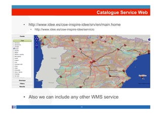
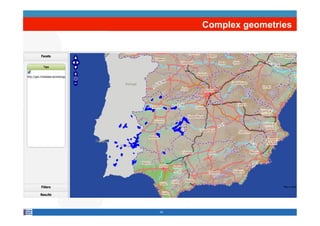
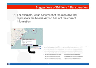
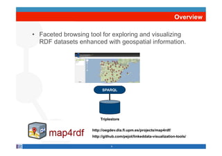
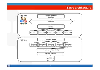
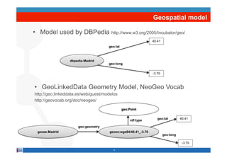
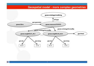
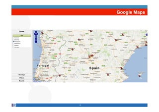
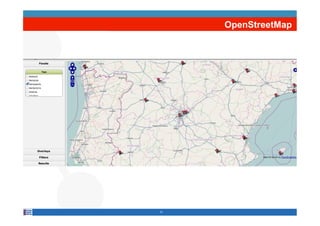
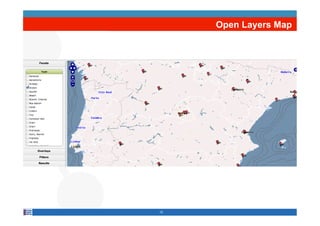
SlideShare a Scribd company logo
1 of 28
Download to read offline
Map4rdf - Faceted Browser for
    Geospatial Datasets
Alexander de León, Filip Wisniewki, Boris Villazón-Terrazas, Oscar Corcho
       Facultad de Informática, Universidad Politécnica de Madrid
     Campus de Montegancedo sn, 28660 Boadilla del Monte, Madrid
                          http://www.oeg-upm.net
                            bvillazon@fi.upm.es
               Phone: 34.91.3366605, Fax: 34.91.3524819
                                  @boricles
        Slides available at: http://www.slideshare.net/boricles/


Acknowledgements: Daniel Garijo, Victor Saquicela, Asunción
Gómez-Pérez, Luis M. Vilches, and all OEG members involved in
the Linked Data initiatives
WorkdistributedunderthelicenseCreativeCommonsAttribution-
Noncommercial-Share Alike 3.0
ToC

•  Motivation

•  Map4rdf overview

•  Use cases

•  Conclusions and future work


                           2
Motivation
Effective usage, develop applications that exploit these data


                          Streaming resources
                               3
Motivation
    Linked Open Data Cloud


4
ToC

•  Motivation

•  Map4rdf overview

•  Use cases

•  Conclusions and future work


                           5
Overview

•  Faceted browsing tool for exploring and visualizing
   RDF datasets enhanced with geospatial information.


              map4rdf        SPARQL


                            Triplestore

                        http://oegdev.dia.fi.upm.es/projects/map4rdf/
                        http://github.com/pejot/linkeddata-visualization-tools/

                                   6
Basic architecture

Web*Client*                         Faceted*Browsing**
                                        Interface*


                                           Event*Bus*


                                            Invoker*


              Command*A* Command*B* Command*C* Command*D* Command*E*


Web*Server*                             Dispatch*Servlet*


              Command*     Command*        Command*         Command*     Command*
              Handler*A*   Handler*B*      Handler*C*       Handler*D*   Handler*E*

                                Data*Access*Object*(DAO)*

                                    SPARQL*Endpoint*


                                          Triplestore*


                                              7
Geospatial model

•  Model used by DBPedia http://www.w3.org/2005/Incubator/geo/
                                                                40.41
                                     geo:lat


                 dbpedia:Madrid
                                     geo:long


                                                                -3.70


•  GeoLinkedData Geometry Model, NeoGeo Vocab
http://geo.linkeddata.es/web/guest/modelos
http://geovocab.org/doc/neogeo/

                                               geo:Point

                                                                   geo:lat         40.41
                                                    rdf:type

                      geo:geometry
 geoes:Madrid                         geoes:wgs84/40.41_-3.70
                                                                        geo:long

                                                                                    -3.70

                                        8
Geospatial model - more complex geometries

                                         geoes:ontology/LineString


                                                         rdf:type

                     geo:geometry
geoes:Ebro                                geoes:resource/7979707


                                                               geoes:ontology/formedBy
                        geoes:ontology/formedBy

     geoes:wsg84/0.67_45.3
                                     …          geoes:wsg84/0.45_45.4                    geo:Point


   geo:lat               geo:long           geo:lat                     geo:long


     40.41                   -3.70               40.41                  -3.70


                                            9
Google Maps


10
OpenStreetMap


11
Open Layers Map


12
Catalogue Service Web

•  http://www.idee.es/csw-inspire-idee/srv/en/main.home
   •  http://www.idee.es/csw-inspire-idee/servicio


•  Also we can include any other WMS service
                                        13
Complex geometries


14
Suggestions of Editions / Data curation

•  For example, let us assume that the resource that
   represents the Murcia Airport has not the correct
   information.


                           15
ToC

•  Motivation

•  Map4rdf overview

•  Use cases

•  Conclusions and future work


                           16
GeoLinkedData

•  An open initiative whose aim is to enrich the Web of
   Data with Spanish geospatial data

•  It started off by publishing diverse information
   sources, such as National Geographic Institute of
   Spain (IGN) and Statistical Institue of Spain (INE).


•  http://geo.linkeddata.es/


                               17
Provinces


18
Integrate data coming from the Statistical Institute


                    19
Provinces – Industry Production Index


Specific visualizations for datasets based on SCOVO and RDF Data Cube

 http://vocab.deri.ie/scovo
 http://www.w3.org/TR/vocab-data-cube/
                                         20
Meteorological Linked Data - AEMET

•  AEMET, Spanish Meteorological Office, data

•  Meteorological data registered by its weather
   stations, radars, lightning detectors and ozone
   soundings.


•  http://aemet.linkeddata.es/


                            21
Weather stations


11/02/11


           22
Observations for each station


11/02/11


           23
A particular observation


Specific visualizations for datasets based on SSN Ontology – ongoing work
  http://www.w3.org/2005/Incubator/ssn/ssnx/ssn
                                   11/02/11


                                          24
ToC

•  Motivation

•  Map4rdf overview

•  Use cases

•  Conclusions and future work


                           25
Conclusions

•  map4rdf for exploring and visualizing RDF datasets.

•  Easy to configure, use and extend

•  It is also used in El Viajero, an application for
   exploiting, managing and organizing Linked Data in
   the domain of news and blogs about traveling
  http://webenemasuno.linkeddata.es/index_en.html


•  Future work

   •  Improve facets visualization
   •  Include more visualizations for specific vocabularies

                                     26
Map4rdf - Faceted Browser for
    Geospatial Datasets
Alexander de León, Filip Wisniewki, Boris Villazón-Terrazas, Oscar Corcho
       Facultad de Informática, Universidad Politécnica de Madrid
     Campus de Montegancedo sn, 28660 Boadilla del Monte, Madrid
                          http://www.oeg-upm.net
                            bvillazon@fi.upm.es
               Phone: 34.91.3366605, Fax: 34.91.3524819
                                  @boricles
        Slides available at: http://www.slideshare.net/boricles/


Acknowledgements: Daniel Garijo, Victor Saquicela, Asunción
Gómez-Pérez, Luis M. Vilches, and all OEG members involved in
the Linked Data initiatives
WorkdistributedunderthelicenseCreativeCommonsAttribution-
Noncommercial-Share Alike 3.0

More Related Content

Similar to Map4rdf - Faceted Browser for Geospatial Datasets

An Approach to Publish Spatial Data on the Web: The GeoLinked Data Use Case
An Approach to Publish Spatial Data on the Web: The GeoLinked Data Use CaseAn Approach to Publish Spatial Data on the Web: The GeoLinked Data Use Case
An Approach to Publish Spatial Data on the Web: The GeoLinked Data Use CaseBoris Villazón-Terrazas
 
2015 FOSS4G Track: Open Specifications for the Storage, Transport and Process...
2015 FOSS4G Track: Open Specifications for the Storage, Transport and Process...2015 FOSS4G Track: Open Specifications for the Storage, Transport and Process...
2015 FOSS4G Track: Open Specifications for the Storage, Transport and Process...GIS in the Rockies
 
One GeoNode, many GeoNodes
One GeoNode, many GeoNodesOne GeoNode, many GeoNodes
One GeoNode, many GeoNodesGeoSolutions
 
Integrating PostGIS in Web Applications
Integrating PostGIS in Web ApplicationsIntegrating PostGIS in Web Applications
Integrating PostGIS in Web ApplicationsCommand Prompt., Inc
 
CartoHeritage 2011: Georeferencer & MapRank Search
CartoHeritage 2011: Georeferencer & MapRank SearchCartoHeritage 2011: Georeferencer & MapRank Search
CartoHeritage 2011: Georeferencer & MapRank SearchPetr Pridal
 
Geo know general presentation 2013
Geo know general presentation 2013Geo know general presentation 2013
Geo know general presentation 2013geoknow
 
The Whitebox Geospatial-Analyisis Tools Project and Open-Access GIS
The Whitebox Geospatial-Analyisis Tools Project and Open-Access GISThe Whitebox Geospatial-Analyisis Tools Project and Open-Access GIS
The Whitebox Geospatial-Analyisis Tools Project and Open-Access GISGolgi Alvarez
 
OpenStreetMap in 3D - current developments
OpenStreetMap in 3D - current developmentsOpenStreetMap in 3D - current developments
OpenStreetMap in 3D - current developmentsvirtualcitySYSTEMS GmbH
 
Data Management and Applications at SOCIB
Data Management and Applications at SOCIBData Management and Applications at SOCIB
Data Management and Applications at SOCIBDavid March
 
Geohistory-Géohistoire Canada: Developing a partnership for historical GIS an...
Geohistory-Géohistoire Canada: Developing a partnership for historical GIS an...Geohistory-Géohistoire Canada: Developing a partnership for historical GIS an...
Geohistory-Géohistoire Canada: Developing a partnership for historical GIS an...nacis_slides
 
Linked Statistical Data: does it actually pay off?
Linked Statistical Data: does it actually pay off?Linked Statistical Data: does it actually pay off?
Linked Statistical Data: does it actually pay off?Oscar Corcho
 
Better Hackathon 2020 - Fraunhofer IAIS - Semantic geo-clustering with SANSA
Better Hackathon 2020 - Fraunhofer IAIS - Semantic geo-clustering with SANSABetter Hackathon 2020 - Fraunhofer IAIS - Semantic geo-clustering with SANSA
Better Hackathon 2020 - Fraunhofer IAIS - Semantic geo-clustering with SANSAPRBETTER
 

Similar to Map4rdf - Faceted Browser for Geospatial Datasets (20)

An Approach to Publish Spatial Data on the Web: The GeoLinked Data Use Case
An Approach to Publish Spatial Data on the Web: The GeoLinked Data Use CaseAn Approach to Publish Spatial Data on the Web: The GeoLinked Data Use Case
An Approach to Publish Spatial Data on the Web: The GeoLinked Data Use Case
 
Geo linked data lstd10(v2-boris)
Geo linked data lstd10(v2-boris)Geo linked data lstd10(v2-boris)
Geo linked data lstd10(v2-boris)
 
2015 FOSS4G Track: Open Specifications for the Storage, Transport and Process...
2015 FOSS4G Track: Open Specifications for the Storage, Transport and Process...2015 FOSS4G Track: Open Specifications for the Storage, Transport and Process...
2015 FOSS4G Track: Open Specifications for the Storage, Transport and Process...
 
One GeoNode, many GeoNodes
One GeoNode, many GeoNodesOne GeoNode, many GeoNodes
One GeoNode, many GeoNodes
 
Integrating PostGIS in Web Applications
Integrating PostGIS in Web ApplicationsIntegrating PostGIS in Web Applications
Integrating PostGIS in Web Applications
 
Open geo data - technical issue
Open geo data  - technical issueOpen geo data  - technical issue
Open geo data - technical issue
 
CartoHeritage 2011: Georeferencer & MapRank Search
CartoHeritage 2011: Georeferencer & MapRank SearchCartoHeritage 2011: Georeferencer & MapRank Search
CartoHeritage 2011: Georeferencer & MapRank Search
 
Geo know general presentation 2013
Geo know general presentation 2013Geo know general presentation 2013
Geo know general presentation 2013
 
The Whitebox Geospatial-Analyisis Tools Project and Open-Access GIS
The Whitebox Geospatial-Analyisis Tools Project and Open-Access GISThe Whitebox Geospatial-Analyisis Tools Project and Open-Access GIS
The Whitebox Geospatial-Analyisis Tools Project and Open-Access GIS
 
OpenStreetMap in 3D - current developments
OpenStreetMap in 3D - current developmentsOpenStreetMap in 3D - current developments
OpenStreetMap in 3D - current developments
 
Intro-EOSC.pptx
Intro-EOSC.pptxIntro-EOSC.pptx
Intro-EOSC.pptx
 
Proyecto geostore
Proyecto geostoreProyecto geostore
Proyecto geostore
 
Geoportal4everybody
Geoportal4everybodyGeoportal4everybody
Geoportal4everybody
 
4 SMART GROUND - COCOON - RAWFILL Workshop
4 SMART GROUND - COCOON - RAWFILL Workshop 4 SMART GROUND - COCOON - RAWFILL Workshop
4 SMART GROUND - COCOON - RAWFILL Workshop
 
Data Management and Applications at SOCIB
Data Management and Applications at SOCIBData Management and Applications at SOCIB
Data Management and Applications at SOCIB
 
Introduction to GIS
Introduction to GISIntroduction to GIS
Introduction to GIS
 
Geohistory-Géohistoire Canada: Developing a partnership for historical GIS an...
Geohistory-Géohistoire Canada: Developing a partnership for historical GIS an...Geohistory-Géohistoire Canada: Developing a partnership for historical GIS an...
Geohistory-Géohistoire Canada: Developing a partnership for historical GIS an...
 
Ecuadorian Geospatial Linked Data
Ecuadorian Geospatial Linked Data Ecuadorian Geospatial Linked Data
Ecuadorian Geospatial Linked Data
 
Linked Statistical Data: does it actually pay off?
Linked Statistical Data: does it actually pay off?Linked Statistical Data: does it actually pay off?
Linked Statistical Data: does it actually pay off?
 
Better Hackathon 2020 - Fraunhofer IAIS - Semantic geo-clustering with SANSA
Better Hackathon 2020 - Fraunhofer IAIS - Semantic geo-clustering with SANSABetter Hackathon 2020 - Fraunhofer IAIS - Semantic geo-clustering with SANSA
Better Hackathon 2020 - Fraunhofer IAIS - Semantic geo-clustering with SANSA
 

More from Boris Villazón-Terrazas

SEEMP - Semantic Aspects and Interoperability
SEEMP - Semantic Aspects and InteroperabilitySEEMP - Semantic Aspects and Interoperability
SEEMP - Semantic Aspects and InteroperabilityBoris Villazón-Terrazas
 
Linguistic resources enhanced with geospatial Information
Linguistic resources enhanced with geospatial InformationLinguistic resources enhanced with geospatial Information
Linguistic resources enhanced with geospatial InformationBoris Villazón-Terrazas
 
RDB2RDF, an overview of R2RML and Direct Mapping
RDB2RDF, an overview of R2RML and Direct MappingRDB2RDF, an overview of R2RML and Direct Mapping
RDB2RDF, an overview of R2RML and Direct MappingBoris Villazón-Terrazas
 
Methodological Guidelines for Publishing Linked Data
Methodological Guidelines for Publishing Linked DataMethodological Guidelines for Publishing Linked Data
Methodological Guidelines for Publishing Linked DataBoris Villazón-Terrazas
 
Linked Data Projects at OEG - Current Status
Linked Data Projects at OEG - Current StatusLinked Data Projects at OEG - Current Status
Linked Data Projects at OEG - Current StatusBoris Villazón-Terrazas
 
A Provenance-Aware Linked Data Application for Trip Management and Organization
A Provenance-Aware Linked Data Application for Trip Management and OrganizationA Provenance-Aware Linked Data Application for Trip Management and Organization
A Provenance-Aware Linked Data Application for Trip Management and OrganizationBoris Villazón-Terrazas
 
Methodological Guidelines for Publishing Linked Data
Methodological Guidelines for Publishing Linked DataMethodological Guidelines for Publishing Linked Data
Methodological Guidelines for Publishing Linked DataBoris Villazón-Terrazas
 
Lightweight Semantic Annotation of Geospatial RESTful Services
Lightweight Semantic Annotation of Geospatial RESTful ServicesLightweight Semantic Annotation of Geospatial RESTful Services
Lightweight Semantic Annotation of Geospatial RESTful ServicesBoris Villazón-Terrazas
 
Methodological Guidelines for Publishing Linked Data
Methodological Guidelines for Publishing Linked DataMethodological Guidelines for Publishing Linked Data
Methodological Guidelines for Publishing Linked DataBoris Villazón-Terrazas
 
A Method for Reusing and Re-engineering Non-ontological Resources for Buildin...
A Method for Reusing and Re-engineering Non-ontological Resources for Buildin...A Method for Reusing and Re-engineering Non-ontological Resources for Buildin...
A Method for Reusing and Re-engineering Non-ontological Resources for Buildin...Boris Villazón-Terrazas
 

More from Boris Villazón-Terrazas (18)

Yet another SPARQL 1.1 brief introduction
Yet another SPARQL 1.1 brief introductionYet another SPARQL 1.1 brief introduction
Yet another SPARQL 1.1 brief introduction
 
iSOCO - Research Lab Brief Introduction
iSOCO - Research Lab Brief IntroductioniSOCO - Research Lab Brief Introduction
iSOCO - Research Lab Brief Introduction
 
SEEMP - Semantic Aspects and Interoperability
SEEMP - Semantic Aspects and InteroperabilitySEEMP - Semantic Aspects and Interoperability
SEEMP - Semantic Aspects and Interoperability
 
Data Shapes and Data Transformations
Data Shapes and Data TransformationsData Shapes and Data Transformations
Data Shapes and Data Transformations
 
Linguistic resources enhanced with geospatial Information
Linguistic resources enhanced with geospatial InformationLinguistic resources enhanced with geospatial Information
Linguistic resources enhanced with geospatial Information
 
RDB2RDF, an overview of R2RML and Direct Mapping
RDB2RDF, an overview of R2RML and Direct MappingRDB2RDF, an overview of R2RML and Direct Mapping
RDB2RDF, an overview of R2RML and Direct Mapping
 
Statistical Linked Data
Statistical Linked DataStatistical Linked Data
Statistical Linked Data
 
Publishing Linked Data from RDB
Publishing Linked Data from RDBPublishing Linked Data from RDB
Publishing Linked Data from RDB
 
Methodological Guidelines for Publishing Linked Data
Methodological Guidelines for Publishing Linked DataMethodological Guidelines for Publishing Linked Data
Methodological Guidelines for Publishing Linked Data
 
Linked Data Projects at OEG - Current Status
Linked Data Projects at OEG - Current StatusLinked Data Projects at OEG - Current Status
Linked Data Projects at OEG - Current Status
 
A Provenance-Aware Linked Data Application for Trip Management and Organization
A Provenance-Aware Linked Data Application for Trip Management and OrganizationA Provenance-Aware Linked Data Application for Trip Management and Organization
A Provenance-Aware Linked Data Application for Trip Management and Organization
 
Methodological Guidelines for Publishing Linked Data
Methodological Guidelines for Publishing Linked DataMethodological Guidelines for Publishing Linked Data
Methodological Guidelines for Publishing Linked Data
 
Lightweight Semantic Annotation of Geospatial RESTful Services
Lightweight Semantic Annotation of Geospatial RESTful ServicesLightweight Semantic Annotation of Geospatial RESTful Services
Lightweight Semantic Annotation of Geospatial RESTful Services
 
Methodological Guidelines for Publishing Linked Data
Methodological Guidelines for Publishing Linked DataMethodological Guidelines for Publishing Linked Data
Methodological Guidelines for Publishing Linked Data
 
A Method for Reusing and Re-engineering Non-ontological Resources for Buildin...
A Method for Reusing and Re-engineering Non-ontological Resources for Buildin...A Method for Reusing and Re-engineering Non-ontological Resources for Buildin...
A Method for Reusing and Re-engineering Non-ontological Resources for Buildin...
 
Geolinkeddata 07042011 1
Geolinkeddata 07042011 1Geolinkeddata 07042011 1
Geolinkeddata 07042011 1
 
Geometry2rdf(v2 boris)
Geometry2rdf(v2 boris)Geometry2rdf(v2 boris)
Geometry2rdf(v2 boris)
 
GeoLinkedData
GeoLinkedDataGeoLinkedData
GeoLinkedData
 

Recently uploaded

ACC 2024 Chronicles. Cardiology. Exam.pdf
ACC 2024 Chronicles. Cardiology. Exam.pdfACC 2024 Chronicles. Cardiology. Exam.pdf
ACC 2024 Chronicles. Cardiology. Exam.pdfSpandanaRallapalli
 
Roles & Responsibilities in Pharmacovigilance
Roles & Responsibilities in PharmacovigilanceRoles & Responsibilities in Pharmacovigilance
Roles & Responsibilities in PharmacovigilanceSamikshaHamane
 
ECONOMIC CONTEXT - LONG FORM TV DRAMA - PPT
ECONOMIC CONTEXT - LONG FORM TV DRAMA - PPTECONOMIC CONTEXT - LONG FORM TV DRAMA - PPT
ECONOMIC CONTEXT - LONG FORM TV DRAMA - PPTiammrhaywood
 
Employee wellbeing at the workplace.pptx
Employee wellbeing at the workplace.pptxEmployee wellbeing at the workplace.pptx
Employee wellbeing at the workplace.pptxNirmalaLoungPoorunde1
 
Crayon Activity Handout For the Crayon A
Crayon Activity Handout For the Crayon ACrayon Activity Handout For the Crayon A
Crayon Activity Handout For the Crayon AUnboundStockton
 
Gas measurement O2,Co2,& ph) 04/2024.pptx
Gas measurement O2,Co2,& ph) 04/2024.pptxGas measurement O2,Co2,& ph) 04/2024.pptx
Gas measurement O2,Co2,& ph) 04/2024.pptxDr.Ibrahim Hassaan
 
Computed Fields and api Depends in the Odoo 17
Computed Fields and api Depends in the Odoo 17Computed Fields and api Depends in the Odoo 17
Computed Fields and api Depends in the Odoo 17Celine George
 
Hierarchy of management that covers different levels of management
Hierarchy of management that covers different levels of managementHierarchy of management that covers different levels of management
Hierarchy of management that covers different levels of managementmkooblal
 
Quarter 4 Peace-education.pptx Catch Up Friday
Quarter 4 Peace-education.pptx Catch Up FridayQuarter 4 Peace-education.pptx Catch Up Friday
Quarter 4 Peace-education.pptx Catch Up FridayMakMakNepo
 
call girls in Kamla Market (DELHI) 🔝 >༒9953330565🔝 genuine Escort Service 🔝✔️✔️
call girls in Kamla Market (DELHI) 🔝 >༒9953330565🔝 genuine Escort Service 🔝✔️✔️call girls in Kamla Market (DELHI) 🔝 >༒9953330565🔝 genuine Escort Service 🔝✔️✔️
call girls in Kamla Market (DELHI) 🔝 >༒9953330565🔝 genuine Escort Service 🔝✔️✔️9953056974 Low Rate Call Girls In Saket, Delhi NCR
 
Introduction to AI in Higher Education_draft.pptx
Introduction to AI in Higher Education_draft.pptxIntroduction to AI in Higher Education_draft.pptx
Introduction to AI in Higher Education_draft.pptxpboyjonauth
 
What is Model Inheritance in Odoo 17 ERP
What is Model Inheritance in Odoo 17 ERPWhat is Model Inheritance in Odoo 17 ERP
What is Model Inheritance in Odoo 17 ERPCeline George
 
Grade 9 Q4-MELC1-Active and Passive Voice.pptx
Grade 9 Q4-MELC1-Active and Passive Voice.pptxGrade 9 Q4-MELC1-Active and Passive Voice.pptx
Grade 9 Q4-MELC1-Active and Passive Voice.pptxChelloAnnAsuncion2
 
Planning a health career 4th Quarter.pptx
Planning a health career 4th Quarter.pptxPlanning a health career 4th Quarter.pptx
Planning a health career 4th Quarter.pptxLigayaBacuel1
 
Field Attribute Index Feature in Odoo 17
Field Attribute Index Feature in Odoo 17Field Attribute Index Feature in Odoo 17
Field Attribute Index Feature in Odoo 17Celine George
 
Framing an Appropriate Research Question 6b9b26d93da94caf993c038d9efcdedb.pdf
Framing an Appropriate Research Question 6b9b26d93da94caf993c038d9efcdedb.pdfFraming an Appropriate Research Question 6b9b26d93da94caf993c038d9efcdedb.pdf
Framing an Appropriate Research Question 6b9b26d93da94caf993c038d9efcdedb.pdfUjwalaBharambe
 
AmericanHighSchoolsprezentacijaoskolama.
AmericanHighSchoolsprezentacijaoskolama.AmericanHighSchoolsprezentacijaoskolama.
AmericanHighSchoolsprezentacijaoskolama.arsicmarija21
 

Recently uploaded (20)

ACC 2024 Chronicles. Cardiology. Exam.pdf
ACC 2024 Chronicles. Cardiology. Exam.pdfACC 2024 Chronicles. Cardiology. Exam.pdf
ACC 2024 Chronicles. Cardiology. Exam.pdf
 
Roles & Responsibilities in Pharmacovigilance
Roles & Responsibilities in PharmacovigilanceRoles & Responsibilities in Pharmacovigilance
Roles & Responsibilities in Pharmacovigilance
 
ECONOMIC CONTEXT - LONG FORM TV DRAMA - PPT
ECONOMIC CONTEXT - LONG FORM TV DRAMA - PPTECONOMIC CONTEXT - LONG FORM TV DRAMA - PPT
ECONOMIC CONTEXT - LONG FORM TV DRAMA - PPT
 
Employee wellbeing at the workplace.pptx
Employee wellbeing at the workplace.pptxEmployee wellbeing at the workplace.pptx
Employee wellbeing at the workplace.pptx
 
Crayon Activity Handout For the Crayon A
Crayon Activity Handout For the Crayon ACrayon Activity Handout For the Crayon A
Crayon Activity Handout For the Crayon A
 
9953330565 Low Rate Call Girls In Rohini Delhi NCR
9953330565 Low Rate Call Girls In Rohini  Delhi NCR9953330565 Low Rate Call Girls In Rohini  Delhi NCR
9953330565 Low Rate Call Girls In Rohini Delhi NCR
 
Gas measurement O2,Co2,& ph) 04/2024.pptx
Gas measurement O2,Co2,& ph) 04/2024.pptxGas measurement O2,Co2,& ph) 04/2024.pptx
Gas measurement O2,Co2,& ph) 04/2024.pptx
 
Computed Fields and api Depends in the Odoo 17
Computed Fields and api Depends in the Odoo 17Computed Fields and api Depends in the Odoo 17
Computed Fields and api Depends in the Odoo 17
 
Hierarchy of management that covers different levels of management
Hierarchy of management that covers different levels of managementHierarchy of management that covers different levels of management
Hierarchy of management that covers different levels of management
 
Quarter 4 Peace-education.pptx Catch Up Friday
Quarter 4 Peace-education.pptx Catch Up FridayQuarter 4 Peace-education.pptx Catch Up Friday
Quarter 4 Peace-education.pptx Catch Up Friday
 
call girls in Kamla Market (DELHI) 🔝 >༒9953330565🔝 genuine Escort Service 🔝✔️✔️
call girls in Kamla Market (DELHI) 🔝 >༒9953330565🔝 genuine Escort Service 🔝✔️✔️call girls in Kamla Market (DELHI) 🔝 >༒9953330565🔝 genuine Escort Service 🔝✔️✔️
call girls in Kamla Market (DELHI) 🔝 >༒9953330565🔝 genuine Escort Service 🔝✔️✔️
 
Introduction to AI in Higher Education_draft.pptx
Introduction to AI in Higher Education_draft.pptxIntroduction to AI in Higher Education_draft.pptx
Introduction to AI in Higher Education_draft.pptx
 
What is Model Inheritance in Odoo 17 ERP
What is Model Inheritance in Odoo 17 ERPWhat is Model Inheritance in Odoo 17 ERP
What is Model Inheritance in Odoo 17 ERP
 
Grade 9 Q4-MELC1-Active and Passive Voice.pptx
Grade 9 Q4-MELC1-Active and Passive Voice.pptxGrade 9 Q4-MELC1-Active and Passive Voice.pptx
Grade 9 Q4-MELC1-Active and Passive Voice.pptx
 
Raw materials used in Herbal Cosmetics.pptx
Raw materials used in Herbal Cosmetics.pptxRaw materials used in Herbal Cosmetics.pptx
Raw materials used in Herbal Cosmetics.pptx
 
Planning a health career 4th Quarter.pptx
Planning a health career 4th Quarter.pptxPlanning a health career 4th Quarter.pptx
Planning a health career 4th Quarter.pptx
 
Field Attribute Index Feature in Odoo 17
Field Attribute Index Feature in Odoo 17Field Attribute Index Feature in Odoo 17
Field Attribute Index Feature in Odoo 17
 
Framing an Appropriate Research Question 6b9b26d93da94caf993c038d9efcdedb.pdf
Framing an Appropriate Research Question 6b9b26d93da94caf993c038d9efcdedb.pdfFraming an Appropriate Research Question 6b9b26d93da94caf993c038d9efcdedb.pdf
Framing an Appropriate Research Question 6b9b26d93da94caf993c038d9efcdedb.pdf
 
Model Call Girl in Bikash Puri Delhi reach out to us at 🔝9953056974🔝
Model Call Girl in Bikash Puri  Delhi reach out to us at 🔝9953056974🔝Model Call Girl in Bikash Puri  Delhi reach out to us at 🔝9953056974🔝
Model Call Girl in Bikash Puri Delhi reach out to us at 🔝9953056974🔝
 
AmericanHighSchoolsprezentacijaoskolama.
AmericanHighSchoolsprezentacijaoskolama.AmericanHighSchoolsprezentacijaoskolama.
AmericanHighSchoolsprezentacijaoskolama.
 

Map4rdf - Faceted Browser for Geospatial Datasets

  • 1. Map4rdf - Faceted Browser for Geospatial Datasets Alexander de León, Filip Wisniewki, Boris Villazón-Terrazas, Oscar Corcho Facultad de Informática, Universidad Politécnica de Madrid Campus de Montegancedo sn, 28660 Boadilla del Monte, Madrid http://www.oeg-upm.net bvillazon@fi.upm.es Phone: 34.91.3366605, Fax: 34.91.3524819 @boricles Slides available at: http://www.slideshare.net/boricles/ Acknowledgements: Daniel Garijo, Victor Saquicela, Asunción Gómez-Pérez, Luis M. Vilches, and all OEG members involved in the Linked Data initiatives WorkdistributedunderthelicenseCreativeCommonsAttribution- Noncommercial-Share Alike 3.0
  • 2. ToC •  Motivation •  Map4rdf overview •  Use cases •  Conclusions and future work 2
  • 3. Motivation Effective usage, develop applications that exploit these data Streaming resources 3
  • 4. Motivation Linked Open Data Cloud 4
  • 5. ToC •  Motivation •  Map4rdf overview •  Use cases •  Conclusions and future work 5
  • 6. Overview •  Faceted browsing tool for exploring and visualizing RDF datasets enhanced with geospatial information. map4rdf SPARQL Triplestore http://oegdev.dia.fi.upm.es/projects/map4rdf/ http://github.com/pejot/linkeddata-visualization-tools/ 6
  • 7. Basic architecture Web*Client* Faceted*Browsing** Interface* Event*Bus* Invoker* Command*A* Command*B* Command*C* Command*D* Command*E* Web*Server* Dispatch*Servlet* Command* Command* Command* Command* Command* Handler*A* Handler*B* Handler*C* Handler*D* Handler*E* Data*Access*Object*(DAO)* SPARQL*Endpoint* Triplestore* 7
  • 8. Geospatial model •  Model used by DBPedia http://www.w3.org/2005/Incubator/geo/ 40.41 geo:lat dbpedia:Madrid geo:long -3.70 •  GeoLinkedData Geometry Model, NeoGeo Vocab http://geo.linkeddata.es/web/guest/modelos http://geovocab.org/doc/neogeo/ geo:Point geo:lat 40.41 rdf:type geo:geometry geoes:Madrid geoes:wgs84/40.41_-3.70 geo:long -3.70 8
  • 9. Geospatial model - more complex geometries geoes:ontology/LineString rdf:type geo:geometry geoes:Ebro geoes:resource/7979707 geoes:ontology/formedBy geoes:ontology/formedBy geoes:wsg84/0.67_45.3 … geoes:wsg84/0.45_45.4 geo:Point geo:lat geo:long geo:lat geo:long 40.41 -3.70 40.41 -3.70 9
  • 13. Catalogue Service Web •  http://www.idee.es/csw-inspire-idee/srv/en/main.home •  http://www.idee.es/csw-inspire-idee/servicio •  Also we can include any other WMS service 13
  • 15. Suggestions of Editions / Data curation •  For example, let us assume that the resource that represents the Murcia Airport has not the correct information. 15
  • 16. ToC •  Motivation •  Map4rdf overview •  Use cases •  Conclusions and future work 16
  • 17. GeoLinkedData •  An open initiative whose aim is to enrich the Web of Data with Spanish geospatial data •  It started off by publishing diverse information sources, such as National Geographic Institute of Spain (IGN) and Statistical Institue of Spain (INE). •  http://geo.linkeddata.es/ 17
  • 19. Integrate data coming from the Statistical Institute 19
  • 20. Provinces – Industry Production Index Specific visualizations for datasets based on SCOVO and RDF Data Cube http://vocab.deri.ie/scovo http://www.w3.org/TR/vocab-data-cube/ 20
  • 21. Meteorological Linked Data - AEMET •  AEMET, Spanish Meteorological Office, data •  Meteorological data registered by its weather stations, radars, lightning detectors and ozone soundings. •  http://aemet.linkeddata.es/ 21
  • 23. Observations for each station 11/02/11 23
  • 24. A particular observation Specific visualizations for datasets based on SSN Ontology – ongoing work http://www.w3.org/2005/Incubator/ssn/ssnx/ssn 11/02/11 24
  • 25. ToC •  Motivation •  Map4rdf overview •  Use cases •  Conclusions and future work 25
  • 26. Conclusions •  map4rdf for exploring and visualizing RDF datasets. •  Easy to configure, use and extend •  It is also used in El Viajero, an application for exploiting, managing and organizing Linked Data in the domain of news and blogs about traveling http://webenemasuno.linkeddata.es/index_en.html •  Future work •  Improve facets visualization •  Include more visualizations for specific vocabularies 26
  • 27.
  • 28. Map4rdf - Faceted Browser for Geospatial Datasets Alexander de León, Filip Wisniewki, Boris Villazón-Terrazas, Oscar Corcho Facultad de Informática, Universidad Politécnica de Madrid Campus de Montegancedo sn, 28660 Boadilla del Monte, Madrid http://www.oeg-upm.net bvillazon@fi.upm.es Phone: 34.91.3366605, Fax: 34.91.3524819 @boricles Slides available at: http://www.slideshare.net/boricles/ Acknowledgements: Daniel Garijo, Victor Saquicela, Asunción Gómez-Pérez, Luis M. Vilches, and all OEG members involved in the Linked Data initiatives WorkdistributedunderthelicenseCreativeCommonsAttribution- Noncommercial-Share Alike 3.0