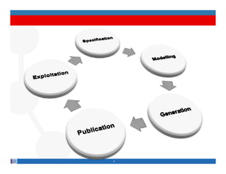
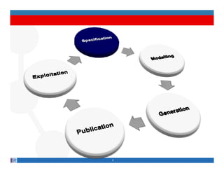
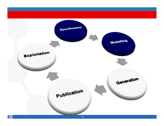
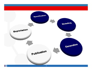
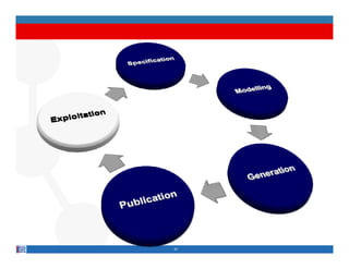
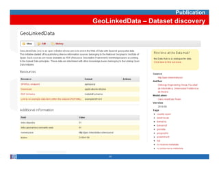
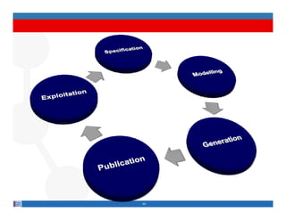
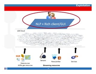
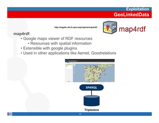
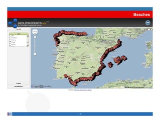
Methodological Guidelines for
   Publishing Linked Data
            g
                Boris Villazón-Terrazas, Oscar Corcho
      Facultad de Informática, Universidad Politécnica de Madrid
                              ,
    Campus de Montegancedo sn, 28660 Boadilla del Monte, Madrid
                       http://www.oeg-upm.net
                    {bvillazon,ocorcho}@fi.upm.es
             Phone: 34 91 3366605 Fax: 34 91 3524819
                     34.91.3366605,       34.91.3524819
      Slides available at: http://www.slideshare.net/boricles/


Acknowledgements: Asunción Gómez-Pérez, Luis M. Vilches,
Victor Saquicela, Al
Vi t S     i l Alexander d L ó and many others th t we
                     d de León,   d        th   that
may have omitted.
WorkdistributedunderthelicenseCreativeCommonsAttribution-
Noncommercial-Share Alike 3.0
Main References

Wood, David (Ed) Linking Government Data - 2011

Methodological Guidelines for Publishing Government Linked Data

Boris Villazón-Terrazas, Luis M. Vilches, Oscar Corcho, Asunción Gómez-Pérez


Best Practices for Publishing Linked Data

W3C Editor’s Draft – Government Linked Data Working Group

Michael Hausenblas, Bernadette Hyland, Boris Villazón-Terrazas

https://dvcs.w3.org/hg/gld/raw-file/bcb72f87b5cc/bp/index.html


Cookbook for Open Government Linked Data

W3C Editor’s Draft – Government Linked Data Working Group

Bernadette Hyland, Boris Villazón-Terrazas, Sarven Capadisli

http://www.w3.org/2011/gld/wiki/Linked_Data_Cookbook
http://www w3 org/2011/gld/wiki/Linked Data Cookbook
Guidelines for Publishing Linked Data

• The process of publishing Linked Data has an
  iterative incremental life cycle model.


• Based on our experience in the production of Linked
  Data in several Governmental Contexts, have been
  applied in real case scenarios.


                           3
4
5
Specification
• Identification and analysis of the data
  sources

• URI design

• Definition of the license


                        6
Specification
            Identification and analysis of the data sources

We have to distinguish

• O
  Open and publish d t th t government agencies h
           d bli h data that         t      i have
  not yet opened up and published
   • Task that may require contacting to specific government data
     owners to get access to their legacy data


• Reuse and leverage on data already opened up and
  p
  published by g
             y government agencies
                           g
   • Task to look for these data in public government catalogs
      • Open Government Data
      • datacatalogs org
        datacatalogs.org
      • Open Government Catalog
                                7
Specification
           Identification and analysis of the data sources

After we have identified and selected the government data
   sources

• Search and compile all the available data and
  documentation about those resources

• Identify the schema of those resources including
  conceptual components and th i relationships
          t l           t    d their l ti   hi

• Identify the items in the domain i e things whose
                            domain, i.e.,
  properties and relations are described in the data
  sources


                           8
Specification
                    GeoLinkedData – Identification of the data sources

                                                      Agreement with the IGN
                IGN
National Geographic Institute of Spain

        Oracle & MySQL


                                                       Data
                                                       D t sources available
                                                                        il bl
                                                      in a public data catalog
         INE
National Statistic Institute of Spain


                                         9
Specification
           GeoLinkedData – Analysis of the data sources


                   Year


Province                             Industry Production Index


                          10
Specification
                                                    URI Design

• Use meaningful URIs, instead of opaque URIs, when
  possible

• Separate TBox (ontology model) from ABox
  (instances) URIs
              URIs.
   • Base URI
     http://data.gov.bo/
     http://health.data.gov.bo/
   • TBox URIs
     http://data.gov.bo/ontology/{class|property}
        p        g            gy {     |p p y}
   • ABox URIs
     http://data.gov.bo/resource/
     http://data.gov.bo/resource/province/Tiraque
     http://data gov bo/resource/province/Tiraque


                                11
Specification
                                   GeoLinkedData - URI design

• Base URI
  http://linkeddata.es/
  http://geo.linkeddata.es/

• TBox URIs
  http://geo.linkeddata.es/ontology/{concept|property}
  http://geo.linkeddata.es/ontology/Provincia
  http://geo linkeddata es/ontology/Provincia

• ABox URIs
  http://geo.linkeddata.es/resource/{r. type}/{r. name}
  http://geo.linkeddata.es/resource/Provincia/Madrid


                              12
Specification
                                      Definition of the license

• Several possibilities

   • The UK Open Government License

   • Open Database License

   • Public Domain Dedication and License

   • Open Data Commons Attribution License

   • The C
         Creative C
                  Commons Licenses


It is also possible to reuse and apply an existing license
           p                      pp y           g
    of the government data sources.
                              13
Specification
                                    GeoLinkedData - Definition of the license

• Reusing the original license of the government data
  sources. IGN and INE data sources have their own
  license, similar t Att ib ti Sh
  li        i il to Attribution-Share Alik 2 5 G
                                       Alike 2.5 Generic
                                                      i
  License


  http://creativecommons.org/licenses/by-sa/2.5/


                                                   14
15
Modelling
                                                                            Ontology


•   An ontology is an engineering artifact, which provides:
     •   A set of terms
     •   A set of explicit assumptions regarding the intended meaning of the terms.
           • Almost always including concepts and their classification
           • Almost always including properties between concepts


•   Shared understanding of a domain of interest

•   Ontologies expressed in OWL or RDF(S), both based on RDF


                                          16
Modelling
                               Reuse available vocabularies


Search f suitable
S    h for it bl
  vocabularies


                                               Linked Open Vocabularies


    are there       Yes                  Build the vocabulary by
     suitable                               reusing available
                                                   g
  vocabularies?                               vocabularies


           No


       …

                          17
Modelling
                 Reuse available non-ontological resources

                                               Highly reliable Web Sites


   Search f suitable
   S     h for it bl                           Domain related
                                               Domain-related sites
non-ontological resources

                                               Government Catalogs


        are there           Yes        Build the vocabulary by
         suitable                      transforming available
                                       t     f    i      il bl
       resources?                              resources


               No


Build the vocabulary from
         scratch


                                  18
Modelling
                                                                                                              GeoLinkedData
                                                                      WGS84 Geo
                                                                   Positioning: an RDF
                                                                       vocabulary                                  scv:Dimension
                                                                                                                      scv:Item
                                                                                                                    scv:Dataset

               hydrographical
             phenomena (rivers,
                 lakes, etc.)


                                                                                                                     Vocabulary for
                                                                                                                     instants, intervals,
                                                                                                                     durations, etc.


                                                                                         Names and
                                                                                         international code
                                  Ontology for OGC                                       systems for
                                  Geography Markup                                       territories and
                                  Language                                               groups


Classes                     33          33
Object Properties           44          44
Data Properties            318         318
                                                     http://neon-toolkit.org/


                                                                   19
Modelling
     GeoLinkedData


20
21
Generation
• Transformation

• Data cleansing

• Linking


                   22
Generation
                                                Transformation

• Take the data sources selected in the specification
  activity and transform them to RDF according to the
  vocabulary created i th modelling activity
       b l         t d in the   d lli   ti it

• Some tools
   • CSV and spreadsheets
      • RDF extension of Google Refine, XLWrap, RDF123, NOR2O
   • RDB
      • D2R Server, ODEMapster, W3C RDB2RDF WG – R2RML
   • XML
      • GRDDL, ReDeFer


                               23
Generation
                                  GeoLinkedData - Transformation


                             NOR2O

       INE


                          ODEMapster


      IGN


             Geospatial       Geometry2RDF
              column


IGN


                                       24
Generation
                                   GeoLinkedData - Transformation
Industry Production Index   Year


Province


                                    NOR2O


                                     25
Generation
                                                      GeoLinkedData - Transformation
•   R2O is an e te s b e, fully dec a at e language to desc be
          s a extensible, u y declarative a guage describe
    mappings between relational database schemas and ontologies.
•   The ODEMapster processor generates RDF instances from
    relational instances based on the mapping description
                                          pp g       p
    expressed in the R2O document


    www.oeg-upm.net/index.php/en/downloads/9-r2o-odempaster
                                                              26
Generation
                       GeoLinkedData - Transformation
• Creation of the R2O Mappings


                         27
Generation
GeoLinkedData - Transformation


            Excerpt of the R2O document


  28
Generation
                                                      GeoLinkedData - Transformation

• Tool for generating RDF from geometrical information

• The geometry could be available in GML or WKT

• The RDF generated follows our Geometry Model


  http://www.oeg-upm.net/index.php/en/downloads/151-geometry2rdf

                                                           29
Generation
 GeoLinkedData - Transformation


                   Oracle STO UTIL package


SELECT TO_CHAR(SDO_UTIL.TO_GML311GEOMETRY(geometry))
          AS Gml311Geometry
FROM "BCN200"."BCN200_0301L_RIO" c
WHERE c.Etiqueta='Arroyo'


     30
Generation
GeoLinkedData - Transformation
Generation
                                                      Data Cleansing

• To find possible errors, identified by Hogan et al.
   • http-level issues, such as accessibility and derefencability,
     e.g.,
     e g HTTP URIs ret rn 40 /50 errors
                        return 40x/50x
   • reasoning issues such as namespace without vocabulary,
     e.g., rss:item term invented
   • malformed/incompatible datatypes, e.g., “true” as xsd:int


• To fix the identified errors


                                 32
Generation
                            GeoLinkedData – Data Cleansing

• Errors
   • Some resources, with the same name, were mixed. For
     example,
     e ample Granada municipality belongs to Granada
                       m nicipalit
     province, and La Granada municipality belongs to Barcelona
     Province.

   • Autonomous communities that only have one province, e.g.,
     Murcia Region, missed some municipalities, but their
     corresponding provinces, e g Murcia Province have the
                   provinces e.g.,       Province,
     correct number of municipalities.

   • S
     Some hydrographical resources missed some parts of their
                                                      f
     geometrical information.


                               33
Generation
                                                                                                          Linking


                     Identify suitable data sets                                       http://ckan.net
                         as linking targets


                       Discover relationships
                        between data items
LIMES                                              Silk Framework
http://aksw.org/Projects/limes                     http://www4.wiwiss.fu-berlin.de/bizer/silk/


                     Validate the relationships
                            discovered              sameAs Validator
                                                    http://oegdev.dia.fi.upm.es:8080/sameAs/


                                                                34
Generation
                                                            GeoLinkedData - Linking


                   GeoLinked
                     Data


                               DBPedia                     GeoNames


        ….                                  ….                               ….

http://dbpedia.org/re              http://geo.linkeddata              http://sws.geoname
   source/Madrid                       .es/.../Madrid                    s.org/6355233/


        ….                                 ….                                 ….

                                                35
Generation
                                                GeoLinkedData - Linking


http://oegdev.dia.fi.upm.es:8080/sameAs/
http://oegdev dia fi upm es:8080/sameAs/


                                           36
37
Publication
• Dataset publication

• Metadata publication

• Dataset discovery


                        38
Publication
                                           Dataset Publication

• Tools for storing RDF
   • Virtuoso Universal Server, Jena, Sesame, 4Store, YARS,
     OWLIM


• SPARQL endpoint and Linked Data frontend
   • Pubby, Talis Platform, Fuseki


                               39
Publication
                                  Metadata Publication

• VoID allows to express metadata about RDF
  datasets


• Open Provenance Model


                          40
Publication
                                                                                   Dataset discovery

• Register the dataset into CKAN Registry

• Generate sitemap files for your dataset, by using
  sitemap4rdf

• Submit the sitemap location to Google and Sindice


  http://www.w3.org/wiki/TaskForces/CommunityProjects/LinkingOpenData/DataSets/CKANmetainformation


                                                       41
Publication
                                               GeoLinkedData – Dataset publication


                               HTML                  Linked Data        SPARQL


     Including Provenance                   Pubby
            Support

http://www4.wiwiss.fu-berlin.de/pubby/   Pubby 0.3


                                                                   Virtuoso 6.1.0
                                                                            610


                                                            42
Publication
GeoLinkedData – Dataset discovery


    43
44
Exploitation


Streaming resources
     45
Exploitation
                                                                      GeoLinkedData

                      http://oegdev.dia.fi.upm.es/projects/map4rdf/


map4rdf:
   • Google maps viewer of RDF resources
       • Resources with spatial information
   • Extensible with google plugins
   • Used in other applications like Aemet Goodrelations
                                     Aemet,


                               map4rdf                 SPARQL


                                                     Triplestore
                                                46
DEMO
http://geo.linkeddata.es/browser


              47
Provinces


48
Capital of Province


49
Provinces – Industry Production Index


 50
Beaches


51
Methodological Guidelines for
   Publishing Linked Data
            g
                Boris Villazón-Terrazas, Oscar Corcho
      Facultad de Informática, Universidad Politécnica de Madrid
                              ,
    Campus de Montegancedo sn, 28660 Boadilla del Monte, Madrid
                       http://www.oeg-upm.net
                    {bvillazon,ocorcho}@fi.upm.es
             Phone: 34 91 3366605 Fax: 34 91 3524819
                     34.91.3366605,       34.91.3524819
      Slides available at: http://www.slideshare.net/boricles/


Acknowledgements: Asunción Gómez-Pérez, Luis M. Vilches,
Victor Saquicela, Al
Vi t S     i l Alexander d L ó and many others th t we
                     d de León,   d        th   that
may have omitted.
WorkdistributedunderthelicenseCreativeCommonsAttribution-
Noncommercial-Share Alike 3.0

Methodological Guidelines for Publishing Linked Data

  • 1.
    Methodological Guidelines for Publishing Linked Data g Boris Villazón-Terrazas, Oscar Corcho Facultad de Informática, Universidad Politécnica de Madrid , Campus de Montegancedo sn, 28660 Boadilla del Monte, Madrid http://www.oeg-upm.net {bvillazon,ocorcho}@fi.upm.es Phone: 34 91 3366605 Fax: 34 91 3524819 34.91.3366605, 34.91.3524819 Slides available at: http://www.slideshare.net/boricles/ Acknowledgements: Asunción Gómez-Pérez, Luis M. Vilches, Victor Saquicela, Al Vi t S i l Alexander d L ó and many others th t we d de León, d th that may have omitted. WorkdistributedunderthelicenseCreativeCommonsAttribution- Noncommercial-Share Alike 3.0
  • 2.
    Main References Wood, David(Ed) Linking Government Data - 2011 Methodological Guidelines for Publishing Government Linked Data Boris Villazón-Terrazas, Luis M. Vilches, Oscar Corcho, Asunción Gómez-Pérez Best Practices for Publishing Linked Data W3C Editor’s Draft – Government Linked Data Working Group Michael Hausenblas, Bernadette Hyland, Boris Villazón-Terrazas https://dvcs.w3.org/hg/gld/raw-file/bcb72f87b5cc/bp/index.html Cookbook for Open Government Linked Data W3C Editor’s Draft – Government Linked Data Working Group Bernadette Hyland, Boris Villazón-Terrazas, Sarven Capadisli http://www.w3.org/2011/gld/wiki/Linked_Data_Cookbook http://www w3 org/2011/gld/wiki/Linked Data Cookbook
  • 3.
    Guidelines for PublishingLinked Data • The process of publishing Linked Data has an iterative incremental life cycle model. • Based on our experience in the production of Linked Data in several Governmental Contexts, have been applied in real case scenarios. 3
  • 4.
  • 5.
  • 6.
    Specification • Identification andanalysis of the data sources • URI design • Definition of the license 6
  • 7.
    Specification Identification and analysis of the data sources We have to distinguish • O Open and publish d t th t government agencies h d bli h data that t i have not yet opened up and published • Task that may require contacting to specific government data owners to get access to their legacy data • Reuse and leverage on data already opened up and p published by g y government agencies g • Task to look for these data in public government catalogs • Open Government Data • datacatalogs org datacatalogs.org • Open Government Catalog 7
  • 8.
    Specification Identification and analysis of the data sources After we have identified and selected the government data sources • Search and compile all the available data and documentation about those resources • Identify the schema of those resources including conceptual components and th i relationships t l t d their l ti hi • Identify the items in the domain i e things whose domain, i.e., properties and relations are described in the data sources 8
  • 9.
    Specification GeoLinkedData – Identification of the data sources Agreement with the IGN IGN National Geographic Institute of Spain Oracle & MySQL Data D t sources available il bl in a public data catalog INE National Statistic Institute of Spain 9
  • 10.
    Specification GeoLinkedData – Analysis of the data sources Year Province Industry Production Index 10
  • 11.
    Specification URI Design • Use meaningful URIs, instead of opaque URIs, when possible • Separate TBox (ontology model) from ABox (instances) URIs URIs. • Base URI http://data.gov.bo/ http://health.data.gov.bo/ • TBox URIs http://data.gov.bo/ontology/{class|property} p g gy { |p p y} • ABox URIs http://data.gov.bo/resource/ http://data.gov.bo/resource/province/Tiraque http://data gov bo/resource/province/Tiraque 11
  • 12.
    Specification GeoLinkedData - URI design • Base URI http://linkeddata.es/ http://geo.linkeddata.es/ • TBox URIs http://geo.linkeddata.es/ontology/{concept|property} http://geo.linkeddata.es/ontology/Provincia http://geo linkeddata es/ontology/Provincia • ABox URIs http://geo.linkeddata.es/resource/{r. type}/{r. name} http://geo.linkeddata.es/resource/Provincia/Madrid 12
  • 13.
    Specification Definition of the license • Several possibilities • The UK Open Government License • Open Database License • Public Domain Dedication and License • Open Data Commons Attribution License • The C Creative C Commons Licenses It is also possible to reuse and apply an existing license p pp y g of the government data sources. 13
  • 14.
    Specification GeoLinkedData - Definition of the license • Reusing the original license of the government data sources. IGN and INE data sources have their own license, similar t Att ib ti Sh li i il to Attribution-Share Alik 2 5 G Alike 2.5 Generic i License http://creativecommons.org/licenses/by-sa/2.5/ 14
  • 15.
  • 16.
    Modelling Ontology • An ontology is an engineering artifact, which provides: • A set of terms • A set of explicit assumptions regarding the intended meaning of the terms. • Almost always including concepts and their classification • Almost always including properties between concepts • Shared understanding of a domain of interest • Ontologies expressed in OWL or RDF(S), both based on RDF 16
  • 17.
    Modelling Reuse available vocabularies Search f suitable S h for it bl vocabularies Linked Open Vocabularies are there Yes Build the vocabulary by suitable reusing available g vocabularies? vocabularies No … 17
  • 18.
    Modelling Reuse available non-ontological resources Highly reliable Web Sites Search f suitable S h for it bl Domain related Domain-related sites non-ontological resources Government Catalogs are there Yes Build the vocabulary by suitable transforming available t f i il bl resources? resources No Build the vocabulary from scratch 18
  • 19.
    Modelling GeoLinkedData WGS84 Geo Positioning: an RDF vocabulary scv:Dimension scv:Item scv:Dataset hydrographical phenomena (rivers, lakes, etc.) Vocabulary for instants, intervals, durations, etc. Names and international code Ontology for OGC systems for Geography Markup territories and Language groups Classes 33 33 Object Properties 44 44 Data Properties 318 318 http://neon-toolkit.org/ 19
  • 20.
    Modelling GeoLinkedData 20
  • 21.
  • 22.
  • 23.
    Generation Transformation • Take the data sources selected in the specification activity and transform them to RDF according to the vocabulary created i th modelling activity b l t d in the d lli ti it • Some tools • CSV and spreadsheets • RDF extension of Google Refine, XLWrap, RDF123, NOR2O • RDB • D2R Server, ODEMapster, W3C RDB2RDF WG – R2RML • XML • GRDDL, ReDeFer 23
  • 24.
    Generation GeoLinkedData - Transformation NOR2O INE ODEMapster IGN Geospatial Geometry2RDF column IGN 24
  • 25.
    Generation GeoLinkedData - Transformation Industry Production Index Year Province NOR2O 25
  • 26.
    Generation GeoLinkedData - Transformation • R2O is an e te s b e, fully dec a at e language to desc be s a extensible, u y declarative a guage describe mappings between relational database schemas and ontologies. • The ODEMapster processor generates RDF instances from relational instances based on the mapping description pp g p expressed in the R2O document www.oeg-upm.net/index.php/en/downloads/9-r2o-odempaster 26
  • 27.
    Generation GeoLinkedData - Transformation • Creation of the R2O Mappings 27
  • 28.
    Generation GeoLinkedData - Transformation Excerpt of the R2O document 28
  • 29.
    Generation GeoLinkedData - Transformation • Tool for generating RDF from geometrical information • The geometry could be available in GML or WKT • The RDF generated follows our Geometry Model http://www.oeg-upm.net/index.php/en/downloads/151-geometry2rdf 29
  • 30.
    Generation GeoLinkedData -Transformation Oracle STO UTIL package SELECT TO_CHAR(SDO_UTIL.TO_GML311GEOMETRY(geometry)) AS Gml311Geometry FROM "BCN200"."BCN200_0301L_RIO" c WHERE c.Etiqueta='Arroyo' 30
  • 31.
  • 32.
    Generation Data Cleansing • To find possible errors, identified by Hogan et al. • http-level issues, such as accessibility and derefencability, e.g., e g HTTP URIs ret rn 40 /50 errors return 40x/50x • reasoning issues such as namespace without vocabulary, e.g., rss:item term invented • malformed/incompatible datatypes, e.g., “true” as xsd:int • To fix the identified errors 32
  • 33.
    Generation GeoLinkedData – Data Cleansing • Errors • Some resources, with the same name, were mixed. For example, e ample Granada municipality belongs to Granada m nicipalit province, and La Granada municipality belongs to Barcelona Province. • Autonomous communities that only have one province, e.g., Murcia Region, missed some municipalities, but their corresponding provinces, e g Murcia Province have the provinces e.g., Province, correct number of municipalities. • S Some hydrographical resources missed some parts of their f geometrical information. 33
  • 34.
    Generation Linking Identify suitable data sets http://ckan.net as linking targets Discover relationships between data items LIMES Silk Framework http://aksw.org/Projects/limes http://www4.wiwiss.fu-berlin.de/bizer/silk/ Validate the relationships discovered sameAs Validator http://oegdev.dia.fi.upm.es:8080/sameAs/ 34
  • 35.
    Generation GeoLinkedData - Linking GeoLinked Data DBPedia GeoNames …. …. …. http://dbpedia.org/re http://geo.linkeddata http://sws.geoname source/Madrid .es/.../Madrid s.org/6355233/ …. …. …. 35
  • 36.
    Generation GeoLinkedData - Linking http://oegdev.dia.fi.upm.es:8080/sameAs/ http://oegdev dia fi upm es:8080/sameAs/ 36
  • 37.
  • 38.
    Publication • Dataset publication •Metadata publication • Dataset discovery 38
  • 39.
    Publication Dataset Publication • Tools for storing RDF • Virtuoso Universal Server, Jena, Sesame, 4Store, YARS, OWLIM • SPARQL endpoint and Linked Data frontend • Pubby, Talis Platform, Fuseki 39
  • 40.
    Publication Metadata Publication • VoID allows to express metadata about RDF datasets • Open Provenance Model 40
  • 41.
    Publication Dataset discovery • Register the dataset into CKAN Registry • Generate sitemap files for your dataset, by using sitemap4rdf • Submit the sitemap location to Google and Sindice http://www.w3.org/wiki/TaskForces/CommunityProjects/LinkingOpenData/DataSets/CKANmetainformation 41
  • 42.
    Publication GeoLinkedData – Dataset publication HTML Linked Data SPARQL Including Provenance Pubby Support http://www4.wiwiss.fu-berlin.de/pubby/ Pubby 0.3 Virtuoso 6.1.0 610 42
  • 43.
  • 44.
  • 45.
  • 46.
    Exploitation GeoLinkedData http://oegdev.dia.fi.upm.es/projects/map4rdf/ map4rdf: • Google maps viewer of RDF resources • Resources with spatial information • Extensible with google plugins • Used in other applications like Aemet Goodrelations Aemet, map4rdf SPARQL Triplestore 46
  • 47.
  • 48.
  • 49.
  • 50.
    Provinces – IndustryProduction Index 50
  • 51.
  • 53.
    Methodological Guidelines for Publishing Linked Data g Boris Villazón-Terrazas, Oscar Corcho Facultad de Informática, Universidad Politécnica de Madrid , Campus de Montegancedo sn, 28660 Boadilla del Monte, Madrid http://www.oeg-upm.net {bvillazon,ocorcho}@fi.upm.es Phone: 34 91 3366605 Fax: 34 91 3524819 34.91.3366605, 34.91.3524819 Slides available at: http://www.slideshare.net/boricles/ Acknowledgements: Asunción Gómez-Pérez, Luis M. Vilches, Victor Saquicela, Al Vi t S i l Alexander d L ó and many others th t we d de León, d th that may have omitted. WorkdistributedunderthelicenseCreativeCommonsAttribution- Noncommercial-Share Alike 3.0