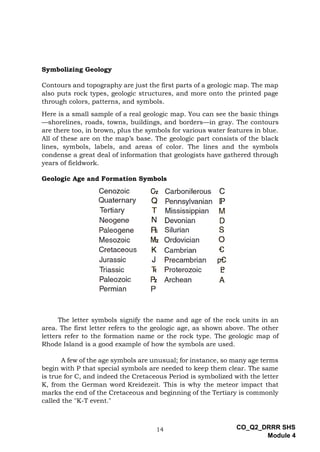
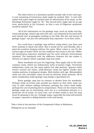
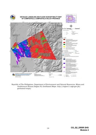
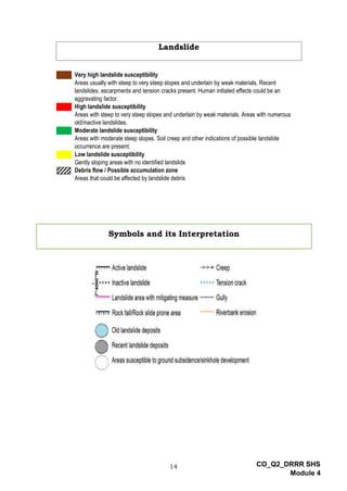
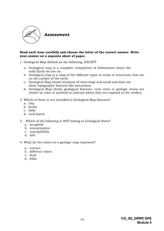
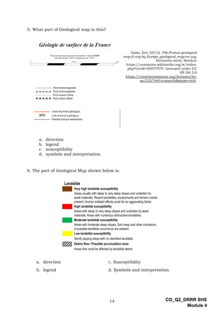
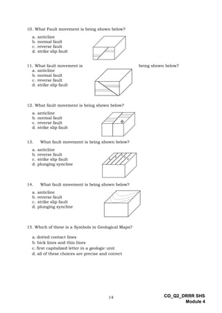
CO_Q2_DRRR SHS
Module 4
Disaster Readiness and
Risk Reduction
Quarter 2 – Module 4:
Interpretation of Geological
Maps
Disaster Readiness and Risk Reduction
Alternative Delivery Mode
Quarter 2 – Module 4: Interpret Geological Maps
First Edition, 2020
Republic Act 8293, section 176 states that: No copyright shall subsist in any work of
the Government of the Philippines. However, prior approval of the government agency or office
wherein the work is created shall be necessary for exploitation of such work for profit. Such
agency or office may, among other things, impose as a condition the payment of royalties.
Borrowed materials (i.e., songs, stories, poems, pictures, photos, brand names,
trademarks, etc.) included in this module are owned by their respective copyright holders.
Every effort has been exerted to locate and seek permission to use these materials from their
respective copyright owners. The publisher and authors do not represent nor claim ownership
over them.
Published by the Department of Education
Secretary: Leonor Magtolis Briones
Undersecretary: Diosdado M. San Antonio
Printed in the Philippines by ________________________
Department of Education – Region IV-A CALABARZON
Office Address: Gate 2 Karangalan Village, Barangay San Isidro
Cainta, Rizal 1800
Telefax: 02-8682-5773/8684-4914/8647-7487
E-mail Address: region4a@deped.gov.ph
Development Team of the Module
Writers: Jimmy D. Geron
Ruby C. Bautista
Editors: Anne Marielle R. Del Mundo
Vanessa A. Bautista
Reviewers: Richard Brian B. Tutor
Gerry S. Romero
Jan Michael De Asis
Catherine Rieta Novillos
Mary Rose Villanueva
Reggie O. Ilag
Dhonabel A. Catelo
Yumi Angela S. Valderama
Illustrator: Ronan DC Vergara
Layout Artist: Maria Elinor F. Hemedes
Ren Mac Mac G. Motas
Management Team: Francis Cesar B. Bringas
Job S. Zape Jr.
Eugenio S. Adrao
Elaine T. Balaogan,
Fe M. Ong-ongowan
Susan DL. Oribiana
Jaypee E. Lopo
Dolorosa S. De Castro
Cristeta M. Arcos
sDisaster Readiness and
Risk Reduction
Quarter 2 – Module 4:
Interpretation of Geological
Maps
1
CO_Q2_DRRR SHS
Module 4
Introductory Message
This Self-Learning Module (SLM) is prepared so that you, our dear learners,
can continue your studies and learn while at home. Activities, questions, directions,
exercises, and discussions are carefully stated for you to understand each lesson.
Each SLM is composed of different parts. Each part shall guide you step-by-
step as you discover and understand the lesson prepared for you.
Pre-tests are provided to measure your prior knowledge on lessons in each
SLM. This will tell you if you need to proceed on completing this module or if you
need to ask your facilitator or your teacher’s assistance for better understanding of
the lesson. At the end of each module, you need to answer the post-test to self-check
your learning. Answer keys are provided for each activity and test. We trust that you
will be honest in using these.
In addition to the material in the main text, Notes to the Teacher are also
provided to our facilitators and parents for strategies and reminders on how they can
best help you on your home-based learning.
Please use this module with care. Do not put unnecessary marks on any part
of this SLM. Use a separate sheet of paper in answering the exercises and tests. And
read the instructions carefully before performing each task.
If you have any questions in using this SLM or any difficulty in answering the
tasks in this module, do not hesitate to consult your teacher or facilitator.
Thank you.
2
CO_Q2_DRRR SHS
Module 4
What I Need to Know
This module will discuss the definition, uses, and interpretation of geological
maps. It shows a major tool of information for the upcoming disaster and
mitigates or reduces of the impact of Rainfall -induced landslide and sinkhole.
The Module is intended to equip you with skills in interpreting geological maps.
After going through this module, you are expected to:
1. identify geological maps, its part and elements;
2. interpret the geological maps and its uses;
3. give an example of geological maps and
4. appreciate the importance of knowing the uses of geological maps.
3
CO_Q2_DRRR SHS
Module 4
What I Know
Read each item carefully and choose the letter of the correct answer. Write
your answer on a separate sheet of paper.
1. Geological Map defined as the following, EXCEPT
a. Geological map is a complete compilation of information about the
solid Earth we live on.
b. Geological map is a map of the different types of rocks or structures that are
on the surface of the earth.
c. Geological Map shows locations of cities large and small and does not
show topographic features like mountains.
d. Geological Map shows geological features, rock units or geologic strata are
shown by color or symbols to indicate where they are exposed at the surface.
2. Which of these is not included in Geological Map features?
a. clay
b. faults
c. folds
d. rock
3. Which of the following is not belong in Geological Parts?
a. incapable
b. interpretation
c. susceptibility
d. title
4. What do the colors on a geologic map represent?
a. contact
b. different colors
c. fault
d. folds
4
CO_Q2_DRRR SHS
Module 4
5. Geological Map has many parts. What part of Geological map is this?
a. direction
b. legend
c. susceptibility
d. symbols and interpretation
6. The part of Geological Map shown below is:
Gaba, Eric (2012). File:France geological map-fr.svg by Europe_geological_map-en.svg. Derivative work: Sémhur
s://commons.wikimedia.org/w/index. php?curid=20457979. Licensed under CC BY-SA 3.0 https://creativecommons.org/licenses/by-
sa/3.0/?ref=ccsearch&atype=rich.
Landslide
Very high landslide susceptibility
Areas usually with steep to very steep slopes and underlain by weak materials. Recent landslides,
escarpments and tension cracks present. Human initiated effects could be an aggravating factor.
High landslide susceptibility
Areas with steep to very steep slopes and underlain by weak materials. Areas with numerous
old/inactive landslides.
Moderate landslide susceptibility
Areas with moderate steep slopes. Soil creep and other indications of possible landslide occurrence
are present.
Low landslide susceptibility
Gently sloping areas with no identified landslide
Debris flow / Possible accumulation zone
Areas that could be affected by landslide debris
a. direction c. Susceptibility
b. legend d. Symbols and interpretation
5
CO_Q2_DRRR SHS
Module 4
7. Which of the following is a Geological Map?
a.
Judgefloro. (2018). File:1881Rosario Roads Cavite
Landmarks Barangays 08.jpg. Photograph.
https://search.creativecommons.org/photos/b26e
082b-ff00-4370-ac06-885ca84a1b44. Marked with
CC0 1.0. https://creativecommons.org/
publicdomain/zero/1.0/deed.en?ref=ccsearch&aty
pe=rich.
b.
Todd, Gary. (2016). "Map of Language & Settlement
Areas of Lumad Groups in Southern Philippines.
Photograph. https://search.creativecommons.org/
photos/9ee229e3-0fff-465e-8ba4-9326ae29cad5.
Marked with CC0 1.0. https://creativecommons.
org/ publicdomain/zero/1.0/deed.en?ref
=ccsearch&atype=rich.
c.
Kulgoyesh19. (2017). File:Generalized Geological
Map of Godavari Drainage Basin.jpg. Digital Image.
https://commons.wikimedia.org/w/index.php?cur
id=62349537. Licensed under CC BY-SA 4.0.
https://creativecommons.org/licenses/by-
sa/4.0/?ref=ccsearch&atype=rich
d.
https://media.wired.com/photos/59269cd37034d
c5f91bec0f1/191:100/w_1280,c_limit/GoogleMap
TA.jpg
8. What part of Geological Map is being shown below?
a. direction c. Sources
b. legend d. Susceptibility
Data Sources:
MGB Geohazard Assessment Team
Lands Geological Survey Division
Geosciences Division MGB Regional Office XI
National Mapping and Resource Information Authority
6
CO_Q2_DRRR SHS
Module 4
9. Which is NOT true about Geological Map?
a. Geological map portrays the distribution of rocks, deposits, or other geologic
features in a specified area.
b. Many different types of lines and symbols are found on geologic maps.
c. Geological maps are uniquely suited to solving problems involving Earth
resources, hazards, and environments.
d. All of these
10. What fault movement is being shown below?
a. anticline
b. normal fault
c. reverse fault
d. strike slip fault
11. What fault movement is being shown below?
a. anticline
b. normal fault
c. reverse fault
d. strike slip fault
12. What fault movement is being shown below?
a. anticline
b. normal fault
c. reverse fault
d. strike slip fault
13. What fault movement is being shown below?
a. anticline
b. reverse fault
c. strike slip fault
d. plunging syncline
14. What fault movement is being shown below?
a. anticline
b. reverse fault
c. strike slip fault
d. plunging syncline
15. Which of these is a symbol in Geological Map?
a. dotted contact lines
b. hick lines and thin lines
c. first capitalized letter in a geologic unit
d. All of these choices are precise and correct.
7
CO_Q2_DRRR SHS
Module 4
Lesson
4
Interpretation of Geological
Maps
What’s In
See picture below and answer the following questions.
HueMan1 (2018). Ph locator laguna calamba.svg. Illustration.
https://commons.wikimedia.org/w/index.php?curid=74387459. Licensed under CC
BY-SA 4.0. https://creativecommons.org/licenses/by-
sa/4.0/?ref=ccsearch&atype=rich
Directions: Answer the following questions. Write your answers on a separate sheet
of paper.
1. What have you observed about the picture?
____________________________________________________________________
____________________________________________________________________
2. Have you experienced using Google Map? When?
____________________________________________________________________
____________________________________________________________________
3. What are the benefits of using Google Map for you and your family? Give at
least 2 answers.
____________________________________________________________________
____________________________________________________________________
8
CO_Q2_DRRR SHS
Module 4
What’s New
ACTIVITY 1: NAME ME!
Directions: Identify the following parts of Geological Map. Write your
answers on a separate sheet of paper.
1. _______________________
2. _______________________
3. _______________________
4. _______________________
5. _______________________
Notes to the Teacher
This Lesson comprises of various activities. Ensure all students
understand the lesson clearly and encourage them to answer
each activity vigorously.
Republic of the Philippines, Department
of Environment and Natural Resources,
Mines and Geosciences Bureau.
Landslide Hazard Map of Barangay
Sipsipin, Municipality of Jalajala, Rizal
Province, Philippines. Map.
http://region4a.mgb.gov.ph/geohazard-
maps/. Marked as free domain. Accessed
30 August 2020.
9
CO_Q2_DRRR SHS
Module 4
What is It
What is a Geological Map?
This type of map shows how geological features, rock units or geologic strata
are shown by colors or symbols to indicate where they are exposed at the
surface.
Geological Maps Features:
1. Faults
2. Tilts
3. Folds
4. Rock layers
Parts of Geological Map:
1. Legend
2. Interpretation
3. Title
4. Susceptibility
5. Sources
Symbols in Geological Maps
1. Thick lines and thin lines
2. First capitalized letter in geologic
unit
3. Colors
4. Dotted contact line
14 CO_Q2_DRRR SHS
Module 4
Symbolizing Geology
Contours and topography are just the first parts of a geologic map. The map
also puts rock types, geologic structures, and more onto the printed page
through colors, patterns, and symbols.
Here is a small sample of a real geologic map. You can see the basic things
—shorelines, roads, towns, buildings, and borders—in gray. The contours
are there too, in brown, plus the symbols for various water features in blue.
All of these are on the map’s base. The geologic part consists of the black
lines, symbols, labels, and areas of color. The lines and the symbols
condense a great deal of information that geologists have gathered through
years of fieldwork.
Geologic Age and Formation Symbols
The letter symbols signify the name and age of the rock units in an
area. The first letter refers to the geologic age, as shown above. The other
letters refer to the formation name or the rock type. The geologic map of
Rhode Island is a good example of how the symbols are used.
A few of the age symbols are unusual; for instance, so many age terms
begin with P that special symbols are needed to keep them clear. The same
is true for C, and indeed the Cretaceous Period is symbolized with the letter
K, from the German word Kreidezeit. This is why the meteor impact that
marks the end of the Cretaceous and beginning of the Tertiary is commonly
called the "K-T event."
14 CO_Q2_DRRR SHS
Module 4
You could have a geologic map without using colors, just lines and
letter symbols in black and white. But it would not be user-friendly, like a
paint-by-numbers drawing without the paint. What colors to use for the
various ages of rocks? There are two traditions that arose in the late 1800s:
the harmonious American standard and the more arbitrary International
standard. The familiarity with the difference between the two makes it
obvious at a glance where a geologic map was made.
These standards are just the beginning. They apply only to the most
common rocks, which are sedimentary rocks of marine origin. Terrestrial
sedimentary rocks use the same palette but add patterns. Igneous rocks
cluster around red colors, while plutonic rocks use lighter shades plus
random patterns of polygonal shapes. Both darken with age. Metamorphic
rocks use rich, secondary colors as well as oriented, linear patterns. All of
these complexities make geologic map design a specialized art.
Every geologic map has its reasons to deviate from the standards.
Perhaps rocks of certain time periods are absent so that other units can
vary in color without adding confusion; perhaps the colors clash badly;
perhaps the cost of printing forces compromises. These are the reasons why
geologic maps are so interesting: each one is a customized solution to a
particular set of needs. In every case, one of those needs is that the map
must be pleasing to the eye. Geologic maps, especially the kind still printed
on paper, represent a dialog between truth and beauty.
Take a look at the province of the Compostela Valley in Mindanao,
Philippines as an example.
The other letters in a formation symbol usually refer to the rock type.
A unit consisting of Cretaceous shale might be marked "Ksh." A unit with
mixed rock types might be marked with an abbreviation of its name, so the
Rutabaga Formation might be "Kr." The second letter might also be an age
term, particularly in the Cenozoic, so that a unit of Oligocene sandstone
would be labeled "Tos."
All of the information on the geologic map—such as strike and dip,
trend and plunge, relative age and rock unit—are obtained by the hard work
and trained eyes of geologists working in the field. But the real beauty of
geologic maps—not just the information they represent—is in their colors.
14 CO_Q2_DRRR SHS
Module 4
Republic of The Philippines, Department of Environment and Natural Resources, Mines and
GeoSciences Bureau Region XI, GeoHazard Maps. http://region11.mgb.gov.ph/
geohazard-maps/
14 CO_Q2_DRRR SHS
Module 4
Landslide
Very high landslide susceptibility
Areas usually with steep to very steep slopes and underlain by weak materials. Recent
landslides, escarpments and tension cracks present. Human initiated effects could be an
aggravating factor.
High landslide susceptibility
Areas with steep to very steep slopes and underlain by weak materials. Areas with numerous
old/inactive landslides.
Moderate landslide susceptibility
Areas with moderate steep slopes. Soil creep and other indications of possible landslide
occurrence are present.
Low landslide susceptibility
Gently sloping areas with no identified landslide
Debris flow / Possible accumulation zone
Areas that could be affected by landslide debris
Symbols and its Interpretation
14 CO_Q2_DRRR SHS
Module 4
Susceptibility
Title
Sources
14 CO_Q2_DRRR SHS
Module 4
Direction of movement on Faults
1. NORMAL FAULT
2. REVERSE FAULT
Coordinate System
Legend
14 CO_Q2_DRRR SHS
Module 4
3. STRIKE SLIP FAULT
4. ANTICLINE
5. PLUNGING SYNCLINE
What’s More
Activity 2: Tell me!
Directions: Study the hazard map below, then answer the following
questions. Use the landslide susceptibility legends previously discussed.
1. What are the different colors used to distinguish different areas
in the map?
2. What do the colors symbolizes in the susceptibility?
3. For each hazard and level susceptibility, what actions should
someone in a particular area take during periods of intense
rain?
14 CO_Q2_DRRR SHS
Module 4
Republic of the Philippines, Department of Environment and Natural Resources, Mines and
Geosciences Bureau. Landslide and Flood Hazard Map of Province of Laguna. Map.
http://region4a.mgb.gov.ph/geohazard-maps/. Marked as free domain. Accessed 30 August 2020.
14 CO_Q2_DRRR SHS
Module 4
What I Have Learned
Directions: Complete the following sentences by giving the appropriate answers
needed in the blank.
Geological Map is _______________________________________________________________
_________________________________________________________________________________
It identified the _________________________________________________________________
_________________________________________________________________________________
It used for _______________________________________________________________________
It is very significant because_____________________________________________________
_________________________________________________________________________________
_________________________________________________________________________________
What I Can Do
A. Do this if you have access to internet.
A.
Download geohazard maps from one of the four source. For MGB
website, follow these simple easy steps:
1. Go to http://.www.mgb.gov.ph
2. Click on the icon on the top left hand-side of the MGB
webpage for GEOHAZARD MAPS. This will bring you to
http://gdis.denr.gov.oh/mgbpublic/ which will show a
map of the Philippines with squares superimposed on top.
14 CO_Q2_DRRR SHS
Module 4
3. Click on the square containing the city or municipality where
the school is located in. This action will download the map in jpeg
format.
4. View the download map.
Again, identify the different elements of the map.
B. Do this if you do not have access to internet or wifi.
Draw a Geological Map of your town and ask your parents about a
brief history of it.
RUBRICS
Criteria 8 12 16 20 TOTAL
Creative
Eye
Catching
Output
Not eye-
catching
Sort of eye
catching,
lacks of
colors and
creativity
Eye-
catching
Captivating
output,
Exceptional
eye
catching
Accurate
Use of
Geological
Informatio
n
Poor use of
geological
information
. Missed a
lot of
information
Average use
of
geological
information
. Missed
some of
importatnt
information
Good use
geological
information
. Included
the
important
points
Exceptional
use of
geological
information
. Found
additional
information
Inclusion
of plants
and
animals
No plants
and
animals
shown in
the ouput
Only plants
or animals
displayed
Appropriate
Plants and
animals
displayed
More than
4 plants
and
animals
displayed
https://www.ndstudies.gov/sites/default/files/images/ggc_poster_r
14 CO_Q2_DRRR SHS
Module 4
Assessment
Read each item carefully and choose the letter of the correct answer. Write
your answer on a separate sheet of paper.
1. Geological Map defined as the following, EXCEPT
a. Geological map is a complete compilation of information about the
solid Earth we live on.
b. Geological map is a map of the different types of rocks or structures that are
on the surface of the earth.
c. Geological Map shows locations of cities large and small and does not
show topographic features like mountains.
d. Geological Map shows geological features, rock units or geologic strata are
shown by color or symbols to indicate where they are exposed at the surface.
2. Which of these is not included in Geological Map features?
a. clay
b. faults
c. folds
d. rock layers
3. Which of the following is NOT belong in Geological Parts?
a. incapable
b. interpretation
c. susceptibility
d. title
4. What do the colors on a geologic map represent?
a. contact
b. different colors
c. fault
d. folds
14 CO_Q2_DRRR SHS
Module 4
5. What part of Geological map is this?
Gaba, Eric (2012). File:France geological
map-fr.svg by Europe_geological_map-en.svg.
Derivative work: Sémhur
https://commons.wikimedia.org/w/index.
php?curid=20457979. Licensed under CC
BY-SA 3.0
https://creativecommons.org/licenses/by-
sa/3.0/?ref=ccsearch&atype=rich.
a. direction
b. legend
c. susceptibility
d. symbols and interpretation
6. The part of Geological Map shown below is:
Landslide
Very high landslide susceptibility
Areas usually with steep to very steep slopes and underlain by
weak materials. Recent landslides, escarpments and tension cracks
present. Human initiated effects could be an aggravating factor.
High landslide susceptibility
Areas with steep to very steep slopes and underlain by weak
materials. Areas with numerous old/inactive landslides.
Moderate landslide susceptibility
Areas with moderate steep slopes. Soil creep and other indications
of possible landslide occurrence are present.
Low landslide susceptibility
Gently sloping areas with no identified landslide
Debris flow / Possible accumulation zone
Areas that could be affected by landslide debris
a. direction c. Susceptibility
b. legend d. Symbols and interpretation
14 CO_Q2_DRRR SHS
Module 4
7. Which of the following is a Geological Map?
a.
Judgefloro. (2018). File:1881Rosario Roads Cavite
Landmarks Barangays 08.jpg. Photograph.
https://search.creativecommons.org/photos/b26e
082b-ff00-4370-ac06-885ca84a1b44. Marked with
CC0 1.0. https://creativecommons.org/
publicdomain/zero/1.0/deed.en?ref=ccsearch&aty
pe=rich.
b.
Todd, Gary. (2016). "Map of Language & Settlement
Areas of Lumad Groups in Southern Philippines.
Photograph. https://search.creativecommons.org/
photos/9ee229e3-0fff-465e-8ba4-9326ae29cad5.
Marked with CC0 1.0. https://creativecommons.
org/ publicdomain/zero/1.0/deed.en?ref
=ccsearch&atype=rich.
c.
Kulgoyesh19. (2017). File:Generalized Geological
Map of Godavari Drainage Basin.jpg. Digital Image.
https://commons.wikimedia.org/w/index.php?cur
id=62349537. Licensed under CC BY-SA 4.0.
https://creativecommons.org/licenses/by-
sa/4.0/?ref=ccsearch&atype=rich
d. All of the above
8. What part of Geological Map is being shown below?
a. direction c. Sources
b. legend d. Susceptibility
9. Which is NOT true about Geological Map?
a. geologic map portrays the distribution of rocks, deposits, or other geologic
features in a specified area.
b. Many different types of lines and symbols are found on geologic maps.
c. Geological maps are uniquely suited to solving problems involving Earth
resources, hazards, and environments.
d. All of These
Data Sources:
MGB Geohazard Assessment Team
Lands Geological Survey Division
Geosciences Division MGB Regional Office XI
National Mapping and Resource Information Authority
14 CO_Q2_DRRR SHS
Module 4
10. What Fault movement is being shown below?
a. anticline
b. normal fault
c. reverse fault
d. strike slip fault
11. What fault movement is being shown below?
a. anticline
b. normal fault
c. reverse fault
d. strike slip fault
12. What fault movement is being shown below?
a. anticline
b. normal fault
c. reverse fault
d. strike slip fault
13. What fault movement is being shown below?
a. anticline
b. reverse fault
c. strike slip fault
d. plunging syncline
14. What fault movement is being shown below?
a. anticline
b. reverse fault
c. strike slip fault
d. plunging syncline
15. Which of these is a Symbols in Geological Maps?
a. dotted contact lines
b. hick lines and thin lines
c. first capitalized letter in a geologic unit
d. all of these choices are precise and correct
14 CO_Q2_DRRR SHS
Module 4
Additional Activities
Directions: On the space provided, make your own geological map in your
area and label its parts.
14 CO_Q2_DRRR SHS
Module 4
Answer Key
Assessment
1.
C
2.
A
3.
A
4.
B
5.
D
6.
C
7.
C
8.
C
9.
D
10.
B
11.
C
12.
D
13.
A
14.
D
15.
D
What's
More
No
specific
answer
needed.
What
I
Know
1.
C
2.
A
3.
A
4.
B
5.
D
6.
C
7.
C
8.
C
9.
D
10.
B
11.
C
12.
D
13.
A
14.
D
15.
D
14 CO_Q2_DRRR SHS
Module 4
References
Andre Alden, How to Read Geologic Map, Thought Co.,June 3, 2019, Dotdash
Publishing Family, https://www.thoughtco.com/how-to-read-a-
geologic- map-1440914
Armanda Briney, January 13, 2020 “Types of Maps: Topographic, Political, climate
and more” https://www.thoughtco.com/types-of-maps- 1435689
Introductory Physical Geology Laboratory Manual- First Canadian Edition, (V.3 Jan
2020), University of Saskatchewan
https://openpress.usask.ca/geolmanual/chapter/exercises-on-folds-
faults- and-unconformities/
Republic of The Philippines, Department of Environment and Natural Resources,
Mines and GeoSciences Bureau Region XI, GeoHazard Maps,
http://region11.mgb.gov.ph/geohazard-maps/
Samuel Bryan Derramas, Rain Induced Landslide, PPDO BOHOL Generate Press ,
November 8, 2012 https://ppdo.bohol.gov.ph/maps/hazard-maps/rain-
indu ced-landslide/
Slideshare, Geological Mapping, August 2, 2018, https://www.slideshare.net/
madanlal47/geological-mapping-108360170
14 CO_Q2_DRRR SHS
Module 4
For inquiries or feedback, please write or call:
Department of Education - Bureau of Learning Resources (DepEd-BLR)
Ground Floor, Bonifacio Bldg., DepEd Complex
Meralco Avenue, Pasig City, Philippines 1600
Telefax: (632) 8634-1072; 8634-1054; 8631-4985
Email Address: blr.lrqad@deped.gov.ph * blr.lrpd@deped.gov.ph

drrr_q2_mod4_informationofgeologicalmap_v2.pdf

  • 1.
    CO_Q2_DRRR SHS Module 4 DisasterReadiness and Risk Reduction Quarter 2 – Module 4: Interpretation of Geological Maps
  • 2.
    Disaster Readiness andRisk Reduction Alternative Delivery Mode Quarter 2 – Module 4: Interpret Geological Maps First Edition, 2020 Republic Act 8293, section 176 states that: No copyright shall subsist in any work of the Government of the Philippines. However, prior approval of the government agency or office wherein the work is created shall be necessary for exploitation of such work for profit. Such agency or office may, among other things, impose as a condition the payment of royalties. Borrowed materials (i.e., songs, stories, poems, pictures, photos, brand names, trademarks, etc.) included in this module are owned by their respective copyright holders. Every effort has been exerted to locate and seek permission to use these materials from their respective copyright owners. The publisher and authors do not represent nor claim ownership over them. Published by the Department of Education Secretary: Leonor Magtolis Briones Undersecretary: Diosdado M. San Antonio Printed in the Philippines by ________________________ Department of Education – Region IV-A CALABARZON Office Address: Gate 2 Karangalan Village, Barangay San Isidro Cainta, Rizal 1800 Telefax: 02-8682-5773/8684-4914/8647-7487 E-mail Address: region4a@deped.gov.ph Development Team of the Module Writers: Jimmy D. Geron Ruby C. Bautista Editors: Anne Marielle R. Del Mundo Vanessa A. Bautista Reviewers: Richard Brian B. Tutor Gerry S. Romero Jan Michael De Asis Catherine Rieta Novillos Mary Rose Villanueva Reggie O. Ilag Dhonabel A. Catelo Yumi Angela S. Valderama Illustrator: Ronan DC Vergara Layout Artist: Maria Elinor F. Hemedes Ren Mac Mac G. Motas Management Team: Francis Cesar B. Bringas Job S. Zape Jr. Eugenio S. Adrao Elaine T. Balaogan, Fe M. Ong-ongowan Susan DL. Oribiana Jaypee E. Lopo Dolorosa S. De Castro Cristeta M. Arcos
  • 3.
    sDisaster Readiness and RiskReduction Quarter 2 – Module 4: Interpretation of Geological Maps
  • 4.
    1 CO_Q2_DRRR SHS Module 4 IntroductoryMessage This Self-Learning Module (SLM) is prepared so that you, our dear learners, can continue your studies and learn while at home. Activities, questions, directions, exercises, and discussions are carefully stated for you to understand each lesson. Each SLM is composed of different parts. Each part shall guide you step-by- step as you discover and understand the lesson prepared for you. Pre-tests are provided to measure your prior knowledge on lessons in each SLM. This will tell you if you need to proceed on completing this module or if you need to ask your facilitator or your teacher’s assistance for better understanding of the lesson. At the end of each module, you need to answer the post-test to self-check your learning. Answer keys are provided for each activity and test. We trust that you will be honest in using these. In addition to the material in the main text, Notes to the Teacher are also provided to our facilitators and parents for strategies and reminders on how they can best help you on your home-based learning. Please use this module with care. Do not put unnecessary marks on any part of this SLM. Use a separate sheet of paper in answering the exercises and tests. And read the instructions carefully before performing each task. If you have any questions in using this SLM or any difficulty in answering the tasks in this module, do not hesitate to consult your teacher or facilitator. Thank you.
  • 5.
    2 CO_Q2_DRRR SHS Module 4 WhatI Need to Know This module will discuss the definition, uses, and interpretation of geological maps. It shows a major tool of information for the upcoming disaster and mitigates or reduces of the impact of Rainfall -induced landslide and sinkhole. The Module is intended to equip you with skills in interpreting geological maps. After going through this module, you are expected to: 1. identify geological maps, its part and elements; 2. interpret the geological maps and its uses; 3. give an example of geological maps and 4. appreciate the importance of knowing the uses of geological maps.
  • 6.
    3 CO_Q2_DRRR SHS Module 4 WhatI Know Read each item carefully and choose the letter of the correct answer. Write your answer on a separate sheet of paper. 1. Geological Map defined as the following, EXCEPT a. Geological map is a complete compilation of information about the solid Earth we live on. b. Geological map is a map of the different types of rocks or structures that are on the surface of the earth. c. Geological Map shows locations of cities large and small and does not show topographic features like mountains. d. Geological Map shows geological features, rock units or geologic strata are shown by color or symbols to indicate where they are exposed at the surface. 2. Which of these is not included in Geological Map features? a. clay b. faults c. folds d. rock 3. Which of the following is not belong in Geological Parts? a. incapable b. interpretation c. susceptibility d. title 4. What do the colors on a geologic map represent? a. contact b. different colors c. fault d. folds
  • 7.
    4 CO_Q2_DRRR SHS Module 4 5.Geological Map has many parts. What part of Geological map is this? a. direction b. legend c. susceptibility d. symbols and interpretation 6. The part of Geological Map shown below is: Gaba, Eric (2012). File:France geological map-fr.svg by Europe_geological_map-en.svg. Derivative work: Sémhur s://commons.wikimedia.org/w/index. php?curid=20457979. Licensed under CC BY-SA 3.0 https://creativecommons.org/licenses/by- sa/3.0/?ref=ccsearch&atype=rich. Landslide Very high landslide susceptibility Areas usually with steep to very steep slopes and underlain by weak materials. Recent landslides, escarpments and tension cracks present. Human initiated effects could be an aggravating factor. High landslide susceptibility Areas with steep to very steep slopes and underlain by weak materials. Areas with numerous old/inactive landslides. Moderate landslide susceptibility Areas with moderate steep slopes. Soil creep and other indications of possible landslide occurrence are present. Low landslide susceptibility Gently sloping areas with no identified landslide Debris flow / Possible accumulation zone Areas that could be affected by landslide debris a. direction c. Susceptibility b. legend d. Symbols and interpretation
  • 8.
    5 CO_Q2_DRRR SHS Module 4 7.Which of the following is a Geological Map? a. Judgefloro. (2018). File:1881Rosario Roads Cavite Landmarks Barangays 08.jpg. Photograph. https://search.creativecommons.org/photos/b26e 082b-ff00-4370-ac06-885ca84a1b44. Marked with CC0 1.0. https://creativecommons.org/ publicdomain/zero/1.0/deed.en?ref=ccsearch&aty pe=rich. b. Todd, Gary. (2016). "Map of Language & Settlement Areas of Lumad Groups in Southern Philippines. Photograph. https://search.creativecommons.org/ photos/9ee229e3-0fff-465e-8ba4-9326ae29cad5. Marked with CC0 1.0. https://creativecommons. org/ publicdomain/zero/1.0/deed.en?ref =ccsearch&atype=rich. c. Kulgoyesh19. (2017). File:Generalized Geological Map of Godavari Drainage Basin.jpg. Digital Image. https://commons.wikimedia.org/w/index.php?cur id=62349537. Licensed under CC BY-SA 4.0. https://creativecommons.org/licenses/by- sa/4.0/?ref=ccsearch&atype=rich d. https://media.wired.com/photos/59269cd37034d c5f91bec0f1/191:100/w_1280,c_limit/GoogleMap TA.jpg 8. What part of Geological Map is being shown below? a. direction c. Sources b. legend d. Susceptibility Data Sources: MGB Geohazard Assessment Team Lands Geological Survey Division Geosciences Division MGB Regional Office XI National Mapping and Resource Information Authority
  • 9.
    6 CO_Q2_DRRR SHS Module 4 9.Which is NOT true about Geological Map? a. Geological map portrays the distribution of rocks, deposits, or other geologic features in a specified area. b. Many different types of lines and symbols are found on geologic maps. c. Geological maps are uniquely suited to solving problems involving Earth resources, hazards, and environments. d. All of these 10. What fault movement is being shown below? a. anticline b. normal fault c. reverse fault d. strike slip fault 11. What fault movement is being shown below? a. anticline b. normal fault c. reverse fault d. strike slip fault 12. What fault movement is being shown below? a. anticline b. normal fault c. reverse fault d. strike slip fault 13. What fault movement is being shown below? a. anticline b. reverse fault c. strike slip fault d. plunging syncline 14. What fault movement is being shown below? a. anticline b. reverse fault c. strike slip fault d. plunging syncline 15. Which of these is a symbol in Geological Map? a. dotted contact lines b. hick lines and thin lines c. first capitalized letter in a geologic unit d. All of these choices are precise and correct.
  • 10.
    7 CO_Q2_DRRR SHS Module 4 Lesson 4 Interpretationof Geological Maps What’s In See picture below and answer the following questions. HueMan1 (2018). Ph locator laguna calamba.svg. Illustration. https://commons.wikimedia.org/w/index.php?curid=74387459. Licensed under CC BY-SA 4.0. https://creativecommons.org/licenses/by- sa/4.0/?ref=ccsearch&atype=rich Directions: Answer the following questions. Write your answers on a separate sheet of paper. 1. What have you observed about the picture? ____________________________________________________________________ ____________________________________________________________________ 2. Have you experienced using Google Map? When? ____________________________________________________________________ ____________________________________________________________________ 3. What are the benefits of using Google Map for you and your family? Give at least 2 answers. ____________________________________________________________________ ____________________________________________________________________
  • 11.
    8 CO_Q2_DRRR SHS Module 4 What’sNew ACTIVITY 1: NAME ME! Directions: Identify the following parts of Geological Map. Write your answers on a separate sheet of paper. 1. _______________________ 2. _______________________ 3. _______________________ 4. _______________________ 5. _______________________ Notes to the Teacher This Lesson comprises of various activities. Ensure all students understand the lesson clearly and encourage them to answer each activity vigorously. Republic of the Philippines, Department of Environment and Natural Resources, Mines and Geosciences Bureau. Landslide Hazard Map of Barangay Sipsipin, Municipality of Jalajala, Rizal Province, Philippines. Map. http://region4a.mgb.gov.ph/geohazard- maps/. Marked as free domain. Accessed 30 August 2020.
  • 12.
    9 CO_Q2_DRRR SHS Module 4 Whatis It What is a Geological Map? This type of map shows how geological features, rock units or geologic strata are shown by colors or symbols to indicate where they are exposed at the surface. Geological Maps Features: 1. Faults 2. Tilts 3. Folds 4. Rock layers Parts of Geological Map: 1. Legend 2. Interpretation 3. Title 4. Susceptibility 5. Sources Symbols in Geological Maps 1. Thick lines and thin lines 2. First capitalized letter in geologic unit 3. Colors 4. Dotted contact line
  • 13.
    14 CO_Q2_DRRR SHS Module4 Symbolizing Geology Contours and topography are just the first parts of a geologic map. The map also puts rock types, geologic structures, and more onto the printed page through colors, patterns, and symbols. Here is a small sample of a real geologic map. You can see the basic things —shorelines, roads, towns, buildings, and borders—in gray. The contours are there too, in brown, plus the symbols for various water features in blue. All of these are on the map’s base. The geologic part consists of the black lines, symbols, labels, and areas of color. The lines and the symbols condense a great deal of information that geologists have gathered through years of fieldwork. Geologic Age and Formation Symbols The letter symbols signify the name and age of the rock units in an area. The first letter refers to the geologic age, as shown above. The other letters refer to the formation name or the rock type. The geologic map of Rhode Island is a good example of how the symbols are used. A few of the age symbols are unusual; for instance, so many age terms begin with P that special symbols are needed to keep them clear. The same is true for C, and indeed the Cretaceous Period is symbolized with the letter K, from the German word Kreidezeit. This is why the meteor impact that marks the end of the Cretaceous and beginning of the Tertiary is commonly called the "K-T event."
  • 14.
    14 CO_Q2_DRRR SHS Module4 You could have a geologic map without using colors, just lines and letter symbols in black and white. But it would not be user-friendly, like a paint-by-numbers drawing without the paint. What colors to use for the various ages of rocks? There are two traditions that arose in the late 1800s: the harmonious American standard and the more arbitrary International standard. The familiarity with the difference between the two makes it obvious at a glance where a geologic map was made. These standards are just the beginning. They apply only to the most common rocks, which are sedimentary rocks of marine origin. Terrestrial sedimentary rocks use the same palette but add patterns. Igneous rocks cluster around red colors, while plutonic rocks use lighter shades plus random patterns of polygonal shapes. Both darken with age. Metamorphic rocks use rich, secondary colors as well as oriented, linear patterns. All of these complexities make geologic map design a specialized art. Every geologic map has its reasons to deviate from the standards. Perhaps rocks of certain time periods are absent so that other units can vary in color without adding confusion; perhaps the colors clash badly; perhaps the cost of printing forces compromises. These are the reasons why geologic maps are so interesting: each one is a customized solution to a particular set of needs. In every case, one of those needs is that the map must be pleasing to the eye. Geologic maps, especially the kind still printed on paper, represent a dialog between truth and beauty. Take a look at the province of the Compostela Valley in Mindanao, Philippines as an example. The other letters in a formation symbol usually refer to the rock type. A unit consisting of Cretaceous shale might be marked "Ksh." A unit with mixed rock types might be marked with an abbreviation of its name, so the Rutabaga Formation might be "Kr." The second letter might also be an age term, particularly in the Cenozoic, so that a unit of Oligocene sandstone would be labeled "Tos." All of the information on the geologic map—such as strike and dip, trend and plunge, relative age and rock unit—are obtained by the hard work and trained eyes of geologists working in the field. But the real beauty of geologic maps—not just the information they represent—is in their colors.
  • 15.
    14 CO_Q2_DRRR SHS Module4 Republic of The Philippines, Department of Environment and Natural Resources, Mines and GeoSciences Bureau Region XI, GeoHazard Maps. http://region11.mgb.gov.ph/ geohazard-maps/
  • 16.
    14 CO_Q2_DRRR SHS Module4 Landslide Very high landslide susceptibility Areas usually with steep to very steep slopes and underlain by weak materials. Recent landslides, escarpments and tension cracks present. Human initiated effects could be an aggravating factor. High landslide susceptibility Areas with steep to very steep slopes and underlain by weak materials. Areas with numerous old/inactive landslides. Moderate landslide susceptibility Areas with moderate steep slopes. Soil creep and other indications of possible landslide occurrence are present. Low landslide susceptibility Gently sloping areas with no identified landslide Debris flow / Possible accumulation zone Areas that could be affected by landslide debris Symbols and its Interpretation
  • 17.
    14 CO_Q2_DRRR SHS Module4 Susceptibility Title Sources
  • 18.
    14 CO_Q2_DRRR SHS Module4 Direction of movement on Faults 1. NORMAL FAULT 2. REVERSE FAULT Coordinate System Legend
  • 19.
    14 CO_Q2_DRRR SHS Module4 3. STRIKE SLIP FAULT 4. ANTICLINE 5. PLUNGING SYNCLINE What’s More Activity 2: Tell me! Directions: Study the hazard map below, then answer the following questions. Use the landslide susceptibility legends previously discussed. 1. What are the different colors used to distinguish different areas in the map? 2. What do the colors symbolizes in the susceptibility? 3. For each hazard and level susceptibility, what actions should someone in a particular area take during periods of intense rain?
  • 20.
    14 CO_Q2_DRRR SHS Module4 Republic of the Philippines, Department of Environment and Natural Resources, Mines and Geosciences Bureau. Landslide and Flood Hazard Map of Province of Laguna. Map. http://region4a.mgb.gov.ph/geohazard-maps/. Marked as free domain. Accessed 30 August 2020.
  • 21.
    14 CO_Q2_DRRR SHS Module4 What I Have Learned Directions: Complete the following sentences by giving the appropriate answers needed in the blank. Geological Map is _______________________________________________________________ _________________________________________________________________________________ It identified the _________________________________________________________________ _________________________________________________________________________________ It used for _______________________________________________________________________ It is very significant because_____________________________________________________ _________________________________________________________________________________ _________________________________________________________________________________ What I Can Do A. Do this if you have access to internet. A. Download geohazard maps from one of the four source. For MGB website, follow these simple easy steps: 1. Go to http://.www.mgb.gov.ph 2. Click on the icon on the top left hand-side of the MGB webpage for GEOHAZARD MAPS. This will bring you to http://gdis.denr.gov.oh/mgbpublic/ which will show a map of the Philippines with squares superimposed on top.
  • 22.
    14 CO_Q2_DRRR SHS Module4 3. Click on the square containing the city or municipality where the school is located in. This action will download the map in jpeg format. 4. View the download map. Again, identify the different elements of the map. B. Do this if you do not have access to internet or wifi. Draw a Geological Map of your town and ask your parents about a brief history of it. RUBRICS Criteria 8 12 16 20 TOTAL Creative Eye Catching Output Not eye- catching Sort of eye catching, lacks of colors and creativity Eye- catching Captivating output, Exceptional eye catching Accurate Use of Geological Informatio n Poor use of geological information . Missed a lot of information Average use of geological information . Missed some of importatnt information Good use geological information . Included the important points Exceptional use of geological information . Found additional information Inclusion of plants and animals No plants and animals shown in the ouput Only plants or animals displayed Appropriate Plants and animals displayed More than 4 plants and animals displayed https://www.ndstudies.gov/sites/default/files/images/ggc_poster_r
  • 23.
    14 CO_Q2_DRRR SHS Module4 Assessment Read each item carefully and choose the letter of the correct answer. Write your answer on a separate sheet of paper. 1. Geological Map defined as the following, EXCEPT a. Geological map is a complete compilation of information about the solid Earth we live on. b. Geological map is a map of the different types of rocks or structures that are on the surface of the earth. c. Geological Map shows locations of cities large and small and does not show topographic features like mountains. d. Geological Map shows geological features, rock units or geologic strata are shown by color or symbols to indicate where they are exposed at the surface. 2. Which of these is not included in Geological Map features? a. clay b. faults c. folds d. rock layers 3. Which of the following is NOT belong in Geological Parts? a. incapable b. interpretation c. susceptibility d. title 4. What do the colors on a geologic map represent? a. contact b. different colors c. fault d. folds
  • 24.
    14 CO_Q2_DRRR SHS Module4 5. What part of Geological map is this? Gaba, Eric (2012). File:France geological map-fr.svg by Europe_geological_map-en.svg. Derivative work: Sémhur https://commons.wikimedia.org/w/index. php?curid=20457979. Licensed under CC BY-SA 3.0 https://creativecommons.org/licenses/by- sa/3.0/?ref=ccsearch&atype=rich. a. direction b. legend c. susceptibility d. symbols and interpretation 6. The part of Geological Map shown below is: Landslide Very high landslide susceptibility Areas usually with steep to very steep slopes and underlain by weak materials. Recent landslides, escarpments and tension cracks present. Human initiated effects could be an aggravating factor. High landslide susceptibility Areas with steep to very steep slopes and underlain by weak materials. Areas with numerous old/inactive landslides. Moderate landslide susceptibility Areas with moderate steep slopes. Soil creep and other indications of possible landslide occurrence are present. Low landslide susceptibility Gently sloping areas with no identified landslide Debris flow / Possible accumulation zone Areas that could be affected by landslide debris a. direction c. Susceptibility b. legend d. Symbols and interpretation
  • 25.
    14 CO_Q2_DRRR SHS Module4 7. Which of the following is a Geological Map? a. Judgefloro. (2018). File:1881Rosario Roads Cavite Landmarks Barangays 08.jpg. Photograph. https://search.creativecommons.org/photos/b26e 082b-ff00-4370-ac06-885ca84a1b44. Marked with CC0 1.0. https://creativecommons.org/ publicdomain/zero/1.0/deed.en?ref=ccsearch&aty pe=rich. b. Todd, Gary. (2016). "Map of Language & Settlement Areas of Lumad Groups in Southern Philippines. Photograph. https://search.creativecommons.org/ photos/9ee229e3-0fff-465e-8ba4-9326ae29cad5. Marked with CC0 1.0. https://creativecommons. org/ publicdomain/zero/1.0/deed.en?ref =ccsearch&atype=rich. c. Kulgoyesh19. (2017). File:Generalized Geological Map of Godavari Drainage Basin.jpg. Digital Image. https://commons.wikimedia.org/w/index.php?cur id=62349537. Licensed under CC BY-SA 4.0. https://creativecommons.org/licenses/by- sa/4.0/?ref=ccsearch&atype=rich d. All of the above 8. What part of Geological Map is being shown below? a. direction c. Sources b. legend d. Susceptibility 9. Which is NOT true about Geological Map? a. geologic map portrays the distribution of rocks, deposits, or other geologic features in a specified area. b. Many different types of lines and symbols are found on geologic maps. c. Geological maps are uniquely suited to solving problems involving Earth resources, hazards, and environments. d. All of These Data Sources: MGB Geohazard Assessment Team Lands Geological Survey Division Geosciences Division MGB Regional Office XI National Mapping and Resource Information Authority
  • 26.
    14 CO_Q2_DRRR SHS Module4 10. What Fault movement is being shown below? a. anticline b. normal fault c. reverse fault d. strike slip fault 11. What fault movement is being shown below? a. anticline b. normal fault c. reverse fault d. strike slip fault 12. What fault movement is being shown below? a. anticline b. normal fault c. reverse fault d. strike slip fault 13. What fault movement is being shown below? a. anticline b. reverse fault c. strike slip fault d. plunging syncline 14. What fault movement is being shown below? a. anticline b. reverse fault c. strike slip fault d. plunging syncline 15. Which of these is a Symbols in Geological Maps? a. dotted contact lines b. hick lines and thin lines c. first capitalized letter in a geologic unit d. all of these choices are precise and correct
  • 27.
    14 CO_Q2_DRRR SHS Module4 Additional Activities Directions: On the space provided, make your own geological map in your area and label its parts.
  • 28.
    14 CO_Q2_DRRR SHS Module4 Answer Key Assessment 1. C 2. A 3. A 4. B 5. D 6. C 7. C 8. C 9. D 10. B 11. C 12. D 13. A 14. D 15. D What's More No specific answer needed. What I Know 1. C 2. A 3. A 4. B 5. D 6. C 7. C 8. C 9. D 10. B 11. C 12. D 13. A 14. D 15. D
  • 29.
    14 CO_Q2_DRRR SHS Module4 References Andre Alden, How to Read Geologic Map, Thought Co.,June 3, 2019, Dotdash Publishing Family, https://www.thoughtco.com/how-to-read-a- geologic- map-1440914 Armanda Briney, January 13, 2020 “Types of Maps: Topographic, Political, climate and more” https://www.thoughtco.com/types-of-maps- 1435689 Introductory Physical Geology Laboratory Manual- First Canadian Edition, (V.3 Jan 2020), University of Saskatchewan https://openpress.usask.ca/geolmanual/chapter/exercises-on-folds- faults- and-unconformities/ Republic of The Philippines, Department of Environment and Natural Resources, Mines and GeoSciences Bureau Region XI, GeoHazard Maps, http://region11.mgb.gov.ph/geohazard-maps/ Samuel Bryan Derramas, Rain Induced Landslide, PPDO BOHOL Generate Press , November 8, 2012 https://ppdo.bohol.gov.ph/maps/hazard-maps/rain- indu ced-landslide/ Slideshare, Geological Mapping, August 2, 2018, https://www.slideshare.net/ madanlal47/geological-mapping-108360170
  • 30.
    14 CO_Q2_DRRR SHS Module4 For inquiries or feedback, please write or call: Department of Education - Bureau of Learning Resources (DepEd-BLR) Ground Floor, Bonifacio Bldg., DepEd Complex Meralco Avenue, Pasig City, Philippines 1600 Telefax: (632) 8634-1072; 8634-1054; 8631-4985 Email Address: blr.lrqad@deped.gov.ph * blr.lrpd@deped.gov.ph