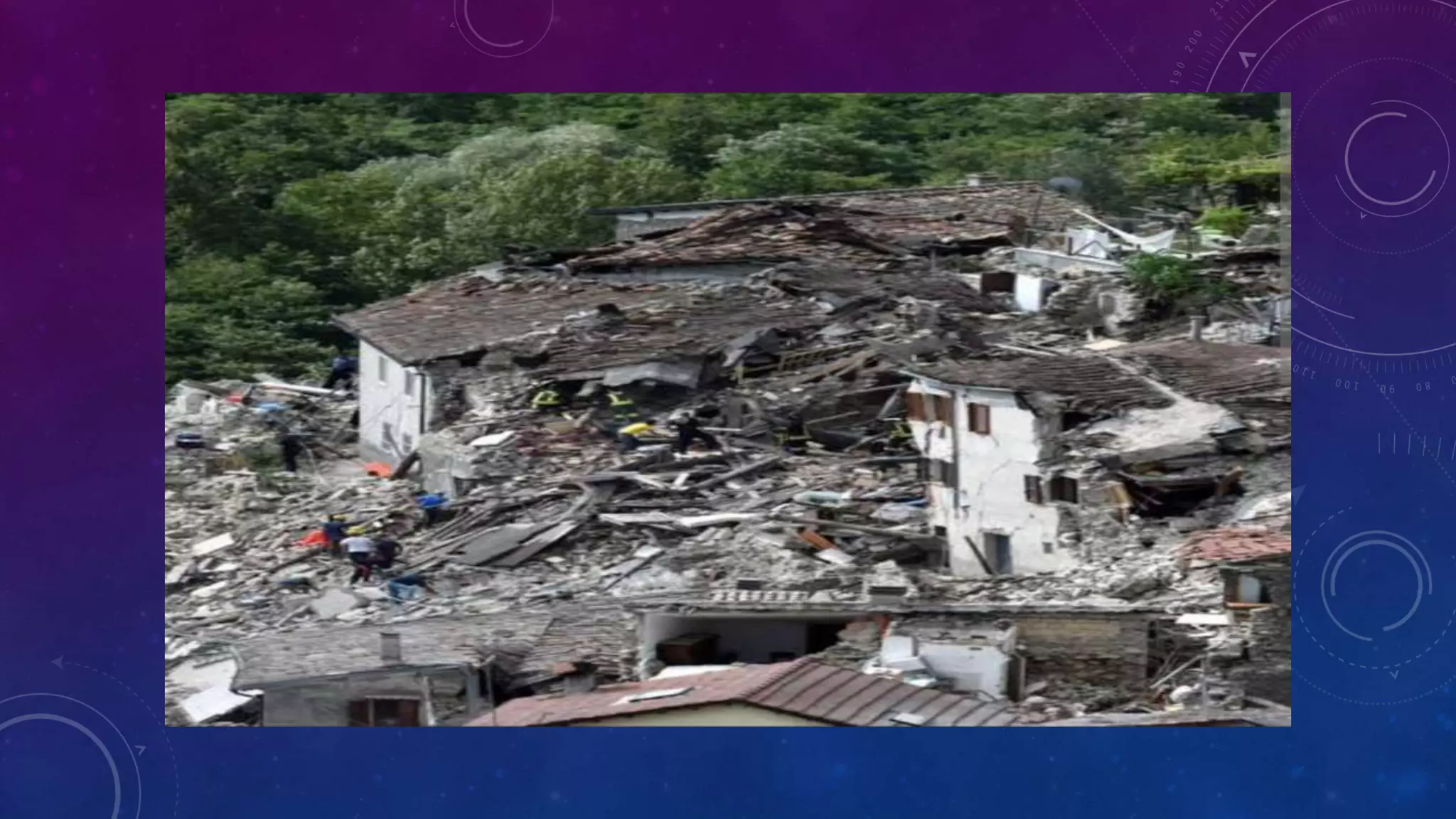
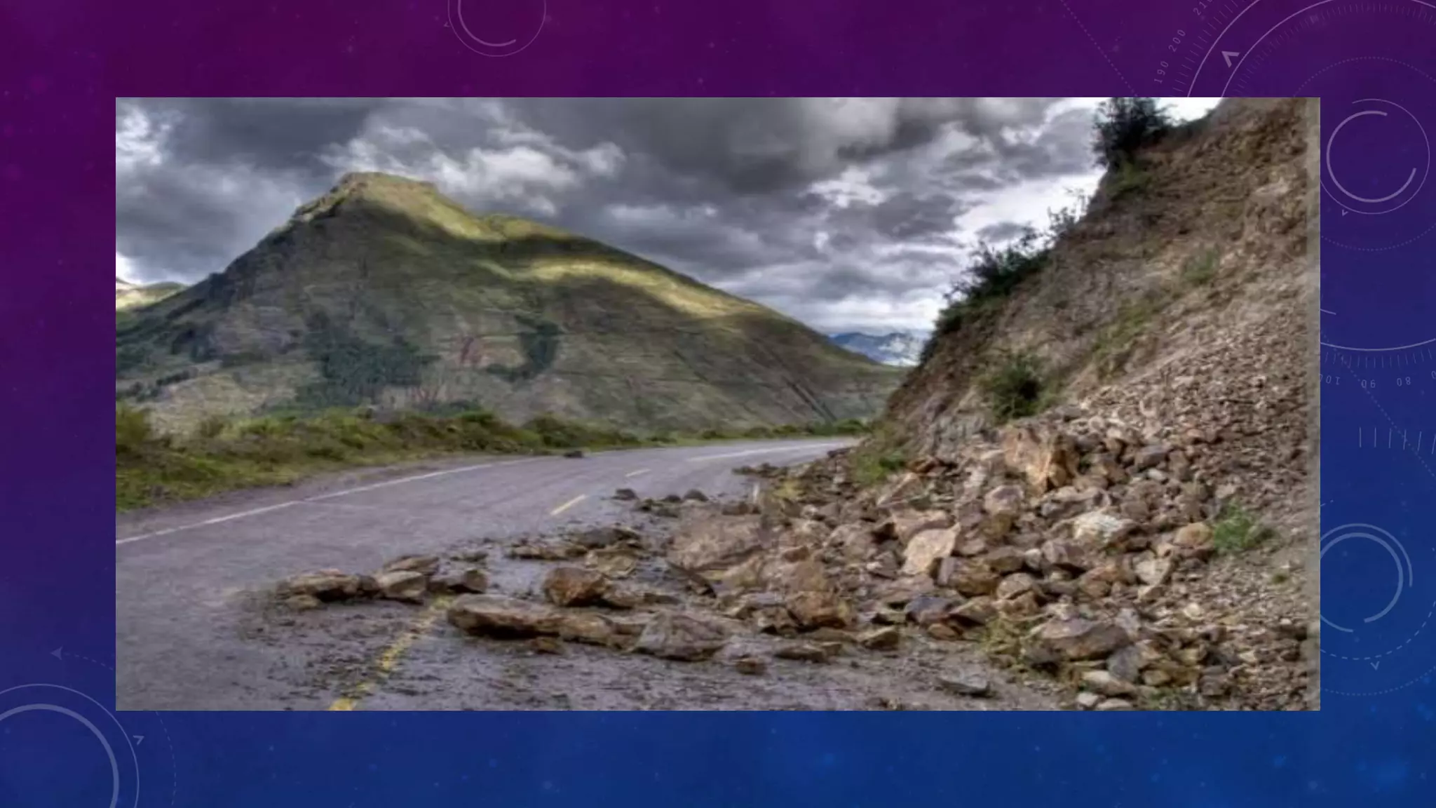
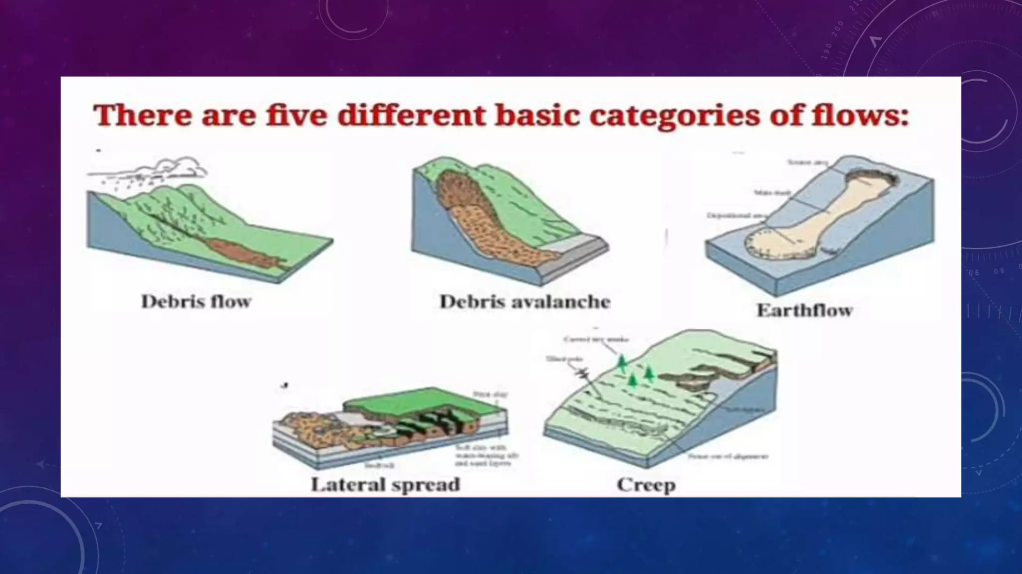
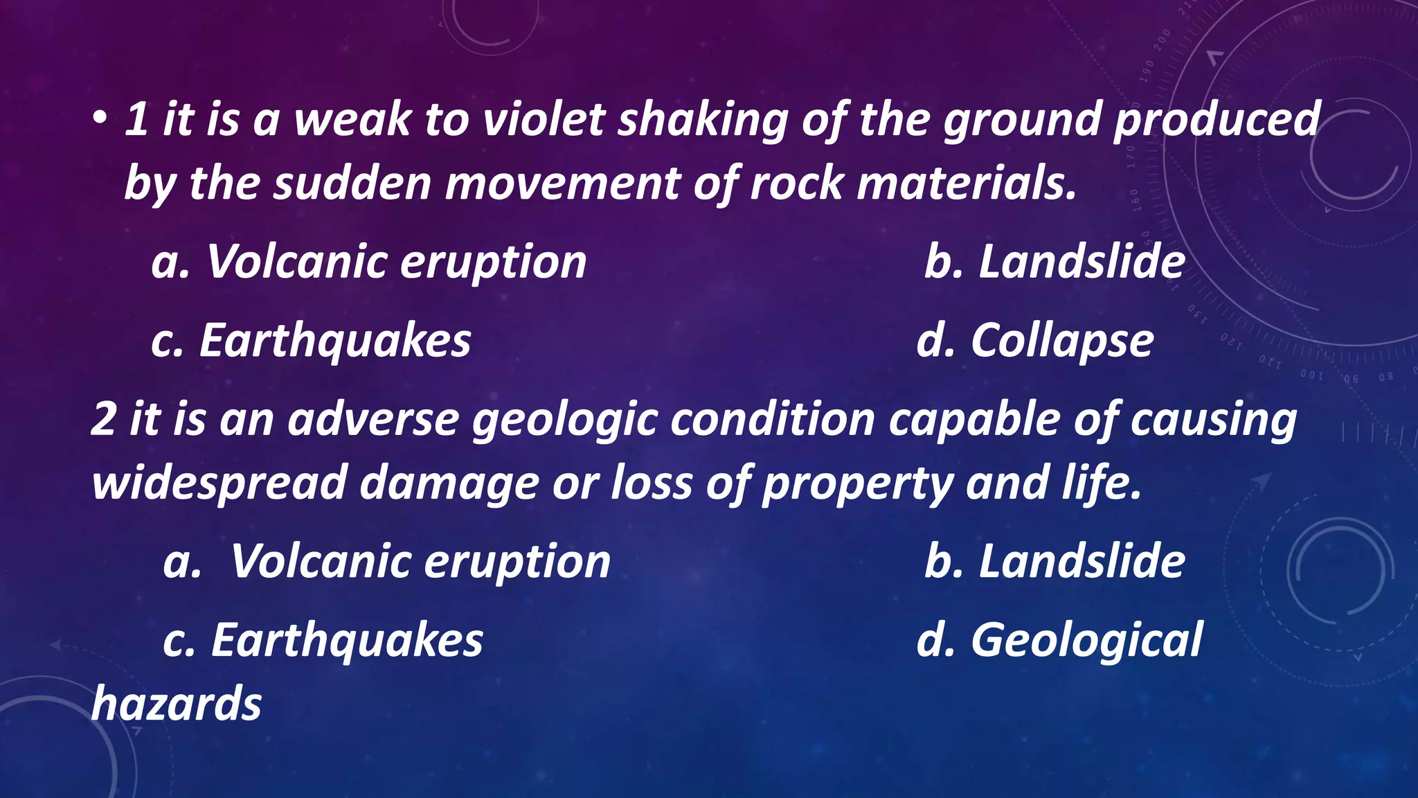
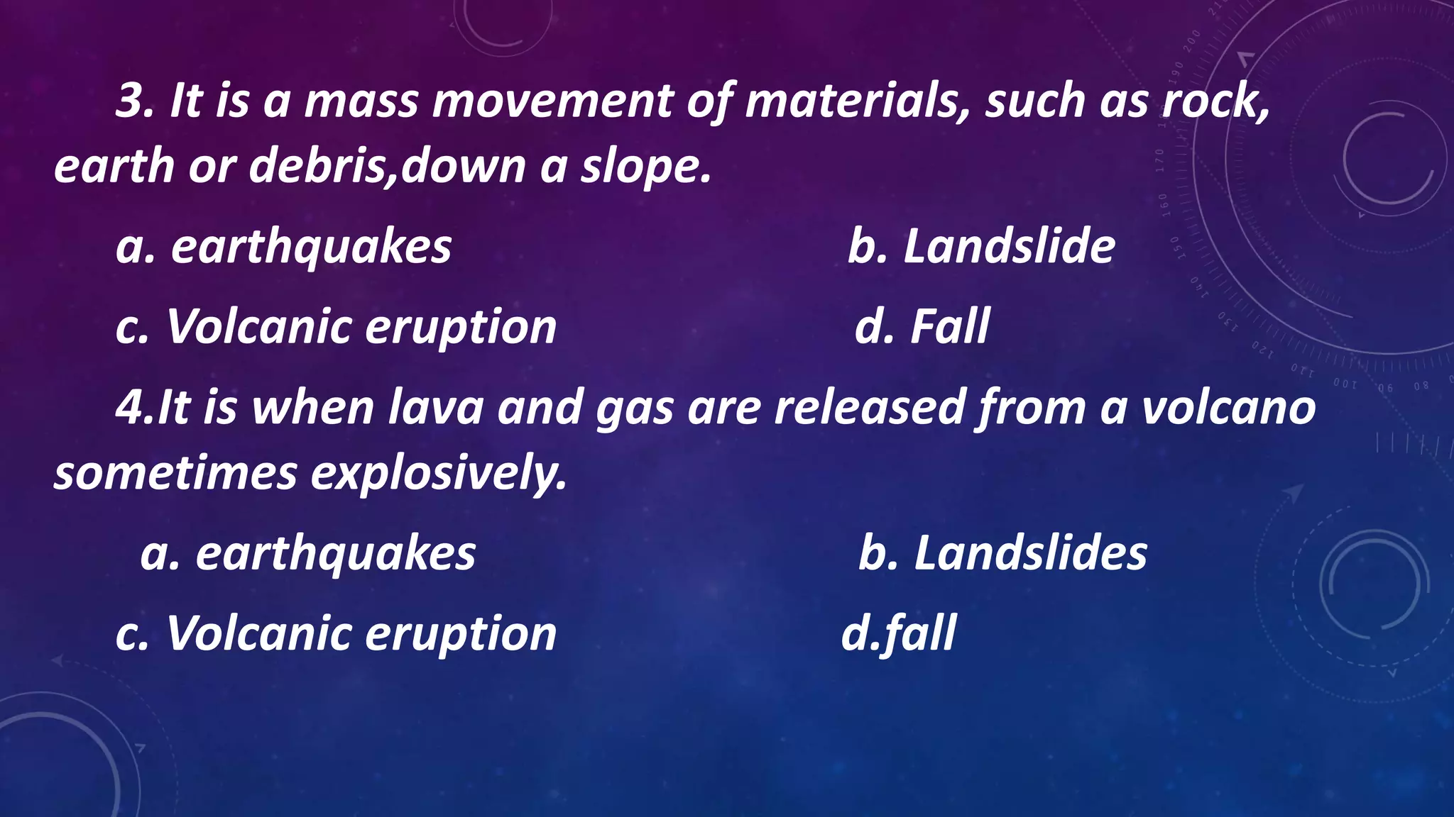
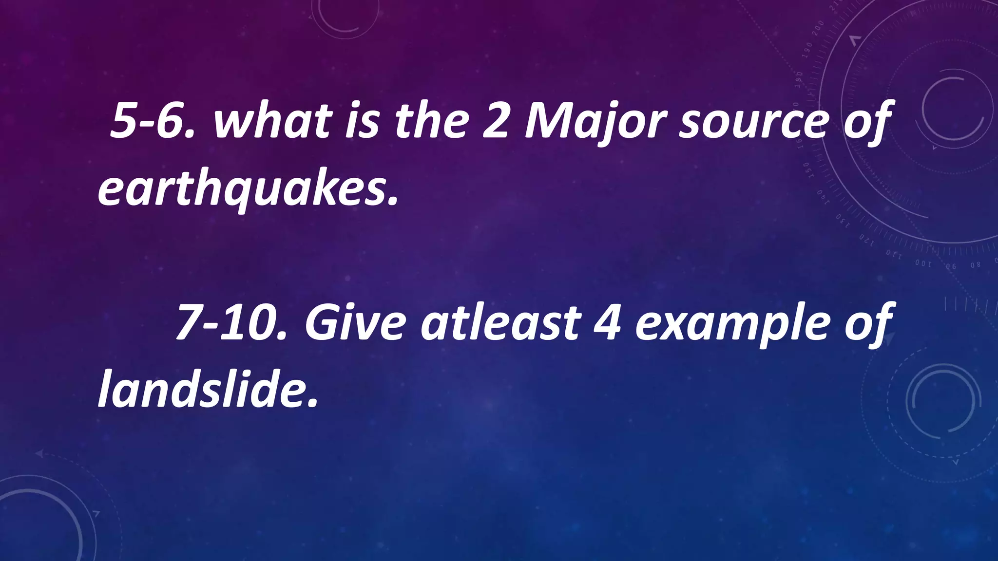
13. DESCRIBE GEOLOGICAL HAZARDS
• A geological hazard or geohazard is an adverse geologic condition capable of causing widespread
damage or loss of property and life. These hazards are geological and environmental conditions,
involve long-term or short-term geological processes.
14.
15. IDENTIFY AND EXPLAIN THE DIFFERENT
GEOLOGICAL HAZARDS
EARTHQUAKES
• An earthquake is a weak to violet shaking of the ground produced by
the sudden movement of rock materials below the earth’s surface,
the earthquakes originate in tectonic plates boundary.
16. 2 MAJOR SOURCE OF EARTHQUAKES
• Tectonic Earthquakes- coused by plate boundary moving slowly the
friction of rocks grinding causes the shaking we feel at an
earthquakes site.
• Volcanic earthquakes- produced by the injection or withdrawal of
magma. These earthquakes can cause land to landslide and can
produce large ground cracks.
17. EFFECTS OF EARTHQUAKES
1). Ground shaking – earthquake generates a large enough shaking
intensity structure like buildings, bridges and dams can be severely
damage and cliffs and sloping ground destabilized.
2). Tsunami – sudden displacement of seawater creating series of
water.
3). Subsidence- sinking of the earth’s surface.
18. 4). Leteral spreading – to have cracks on the ground.
5). Liquefaction – due to the changes in the soil structure because of the
movement. The stiffness of the soil is loosened and sometimes combined
with ground water resulting to liquefaction.
19.
20. VOLCANIC ERUPTION
• A volcanic eruption is when lava and gas are released from a
volcano sometimes explosively. The most dangerous type of
eruption is called a 'glowing a valanche’ which is when freshly
erupted magma flow down the sides of a volcano. They can travel
quickly ang reach temperatures of up to 1,200 degrees Fahrenheit.
21. 2 TYPES OF VOLCANIC ERUPTION
• Explosive eruption- are characterized by gas driven explosions
that propels magma and tephra.
• Effusive eruptions- meanwhile, are characterized by the
outpouring of lava without significant explosive eruption.
22. EFFECTS OF VOLCANIC ERUPTION
• 1) volcanic hazards occur before during and after volcanic eruption.
• 2) earthquakes ground fracturing swelling of the ground gas emissions and steam explosions are signs that a volcano will
erupt.
• 3) Large explosive eruptions send columns of volcanic ash, rocks and gas into the atmosphere and if the ash column
collapses pyroclastic material flow down to the lowest part of the land which may cause landslide.
• 4) after an eruption heavly rainfall will continue to generate lahars as long as loose volcanic debris and ash are on the
ground generation of lahars can continue for decades just like the 1991 mt. Pinatubo eruption in the Philippines.
23.
24. LANDSLIDE
• A landslide is a mass movement of materials, such as rock, earth or
debris, down a slope. They can happen suddenly or more slowly
over long period of time. When the force of gravity acting on a
slope exceeds the resisting forces of a slope, the slope will fail and
a landslide occurs.
25. 5 TYPES OF LANDSLIDE
• Fall- landslide that involve the collapse of material from a cliff or
steep slope.
• Topples- a block of rock that tilts or rotates.
• Slides- displacement of material along one or mare discrete
shearing surface.
26. • Spreads- involve sudden horizontal movement on very gentle
terrain.
• Flows- distinct type of mass movement commonly triggered by
intense rainfall and lot melting snow on steep hill slopes.
27.
28. FACTORS THAT CAN INITIATE SLOPE
MOVEMENTS:
• 1. Typhoon 6. Change in ground water
• 2. Snowmelt 7. Earthquakes
• 3. Changes in water level 8. Volcanic activity
• 4. Stream 9. Disappearance of vegetation by wildfire
• 5. Erosion 10. Disturbance by human activities
29. EFFECT OF LANDSLIDE
• The effect landslides have on humans are property
damage injury and even death water supplies fisheries
sewage disposals systems forest, dams and road ways
can be damage and affected for years.
30. EXPLAIN HOW HAZARD MAPS HELP TO IDENTIFY AREAS
PRONE TO HAZARDS BROUGHT BY EARTHQUAKES, VOLCANIC
ERUPTION, AND LANDSLIDE
• A geological hazards map is a map indicating the areas that are
vulnerable to hazards caused by earthquakes, volcanic eruption,and
landslide. It help the public be informed and prepared for the geological
hazard. You must take note of the title, symbols and legend and source
when studying a geological hazards map.
31. EVALUATE THE USEFULNESS OF HAZARDS MAP
• Hazard map provid important information to help people understand the
risks of natural hazards and to help mitigate disaster. Hazard maps
indicate and can be combined with disaster management information
such as evacuation sites, evacuation routes and so forth.
33. • 1 it is a weak to violet shaking of the ground produced
by the sudden movement of rock materials.
a. Volcanic eruption b. Landslide
c. Earthquakes d. Collapse
2 it is an adverse geologic condition capable of causing
widespread damage or loss of property and life.
a. Volcanic eruption b. Landslide
c. Earthquakes d. Geological
hazards
34. 3. It is a mass movement of materials, such as rock,
earth or debris,down a slope.
a. earthquakes b. Landslide
c. Volcanic eruption d. Fall
4.It is when lava and gas are released from a volcano
sometimes explosively.
a. earthquakes b. Landslides
c. Volcanic eruption d.fall
35. 5-6. what is the 2 Major source of
earthquakes.
7-10. Give atleast 4 example of
landslide.