Download to read offline


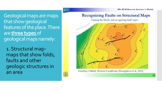


Geological maps are important for understanding landslide and sinkhole hazards for several reasons: 1. Geological maps show the distribution and types of rock and soil materials in an area. Certain rock and soil types are more prone to landslides or developing sinkholes. 2. Geological structures like faults and folds are depicted on geological maps. Areas around geological structures may be more susceptible to slope failures or subsidence. 3. Topographic information on geological maps like slope gradients and elevation can help identify areas of existing or potential slope instability that could lead to landslides. Steep slopes are a risk factor. 4. Geological maps indicate the location of karst terrain where limestone bedrock can be dissolved by groundwater, leading to


