1. Love and peace for our country , Ethiopia!!
CHAPTER ONE: RIVER MORPHOLOGY
By inst. Amanuel B. MSC (HYDRAULIC ENGINEERING)
2. 1.1.1 River
River is any body of fresh water flowing from an upland source to a large
lake or to the sea, fed by such sources as springs and tributary streams.
Rivers can be classified according to various criteria;
1) Based on variation of discharge
2) Based on Location of reach
3) Based on plan-form
1. Based on variation of discharge
A. Perennial Rivers:
✓ Have adequate discharge thought out the year
✓Obtain their supply from melting of snow and from precipitation
B. Non - Perennial Rivers:
✓Are not snow fed
1.1 Introduction
3. Cont’d
✓Obtain the supply from rain
✓The flow is high during and after raining season,
✓But they carry little flow in non-rainy season
c. Flashy Rivers:
✓The Rivers in which there is a sudden increase discharge
✓The river stage rises and then falls in a very short period
✓However, a small flow in a flashy river may continue after
the flood
D. Virgin Rivers:
✓ Get completely dried up due to large evaporation and
percolation losses before joining another river or sea
✓Such rivers exist in arid regions
2. Based on location of reach
A. Mountainous rivers:
✓ Flow in hilly and mountainous regions
✓ Are further divided in to rocky rivers and Boulder
4. Cont’d
✓Rivers.[Rocky stage & Boulder stages].
B. Rivers in flood plains:
✓After the boulder stage, a river enters the flooded plains having
alluvial soil
✓The bed and banks of rivers in flood plains are made up of sand
and silt
C. Delta rivers:
✓When a river enters in to deltaic plain, It sprits up in to a number
of small branches due to very flat slopes.
✓There is a shoal formation and braiding of the channels in the
delta rivers
D. Tidal rivers:
✓Just before joining sea or an ocean, the river becomes as tidal
river
✓In a Tidal River there are periodic changes in water levels due to
tides
5. Cont’d
✓The river receives the sea water during flood tides, but during ebb
tides it delivers in to the sea.
3. Based on plan-form
A. Straight rivers:
✓ Straight In plan and have cross sectional shape of a trough.
✓The max velocity of flow usually occurs in the middle of the section.
✓ May easiest in the mountainous regions but they are rare in flood plains.
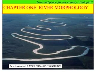
B. Meandering rivers
✓ Follow a winding, crooked course;
✓Consist of a series of bends of alternate curvature in the plan.
6. Cont’d
✓The successive curves are connected by small straight reaches of
the river, called cross rivers or crossings
C. Braided rivers:
✓A breaded river flows in two or more channels around alluvial
Islands developed due to deposition of silt.
River channel patterns
7. Cont’d
❑ Rivers may be also classified as;
✓ Perennial:-continuous flow (have adequate discharge though
out the year, there is dependable base flow contribution)
✓ Ephemeral:-flows only for short period during or following
precipitation (less than 30 days per year)
✓ Intermittent:-flow only during certain times of the year
(seasonal flow, lasts more than 30 days per year).
Rivers also have multitude of functions, which includes the
following:
✓ Social/ economic/ cultural functions
✓ Ecological functions
8. Cont’d
❑ Rivers are complex dynamic systems interaction between:
➢ Hydrodynamics,
➢ Morphodynamics
➢ Ecological processes.
❑ Rivers are continuously change their forms and patterns and other
morphological characteristics in space and time due changes in:
➢ Water discharge
➢ Sediment discharge
The changes in water and sediment discharge may be caused by
1. Natural elements (natural forces)
✓ Discharge is naturally variable.
2. Anthropogenic elements
✓ Human interference in the fluvial system it includes:
9. Cont’d
a. Land developments
❖ Land clearance
❖ Infrastructure building
❖ Land use change
b. River developments
❖ Hydraulic structures
❖ River channelization
❖ Gravel and sand mining
River morphology is the study of the forms and patterns of
rivers and the processes that developed those forms.
It is time dependent and varies particularly with discharge,
sediment input and characteristics, and with bank material
10. Cont’d
River forms and patterns:
➢ River channel geometry
➢ River channel pattern/ planform
➢ River channel planform geometry
➢ River bed grade/ slope
River morphological processes: processes due to flowing water
➢ Erossion
➢ Transportation
➢ Deposition
River forms and patterns and morphological processes interact in a feedback
mechanism.
11. Cont’d
why good understanding of sediment transport process is important? Reasons:-
✓ Morphological boundary conditions for design of hydraulic structures and
river training works.
✓ Sedimentation in Reservoirs
12. Cont’d
✓ Sediment problems at Intakes
✓ Environmental Impact Assessment
1.2 Watershed/ Catchment
➢ The concept of watershed is important in the river system
➢ Because rivers do not exist in isolation.
➢ They are part of a larger system – fluvial system
Total area from which surface runoff flows to a given point of concentration is
called a watershed, a catchment area, a drainage basin, or a drainage area.
Hence a watershed is always connected to a certain point of concentration, the
lowest point of the respective basin.
13. Cont’d
Watershed boundaries
The imaginary line delimiting various watersheds is known as water dividing
line or water-divide.
Watershed geomorphology/ characteristics
➢ Drainage area – A
✓ It is the single most important watershed characteristics for hydrologic design
✓ It reflects the volume of water that can be generated from precipitation
✓V = Rainfall depth x Area
14. Cont’d
➢ Watershed Length - L
✓ It is the second most important watershed characteristics in
hydrologic design.
✓ It is useful for the computation of the concentration time - Tc;
✓ It is the distance measured along the main channel from the
watershed outlet to the basin divide;
✓ While the length increases, the drainage area increases
➢ Watershed Slope – S
✓ Flood magnitudes reflect the momentum of the runoff. Slope is an
important factor in the momentum.
✓ Watershed slope reflects the rate of change of elevation with respect
to distance along the principal flow path.
15. Cont’d
➢ Watershed Shape
✓ Watersheds have an infinite variety of shapes;
✓ Not used directly in hydrologic design
Hypothetical watersheds. (a) Ellipse: side; (b) triangle: center; (c)
square:Comer; (d) circle; (e) triangle: vertex; (f) rectangle; (g) ellipse:
end.
16. Cont’d
In spite of the infinite number of possible watershed shapes, the majority may
nevertheless be usually reduced to three main configuration groups (Fig.below):
✓ elongated watershed,
✓ broad watershed, and
✓ fan-shaped watershed
Fig. watershed shapes
Effect of Watershed Shape on the Runoff Flow
There are many factors which influence the hydraulic characteristics of a watershed
as a part of an overall fluvial system. These factors may generally be summarized as
follows:
✓ Watershed geometry - which, among others, includes area, shape, location,
length of streams, average main-stream slope, drainage density, etc.
✓ Soil characteristics - type of soil, grain-size distribution, texture, erosivity, etc.
17. Cont’d
✓ Vegetation cover - types and distribution, interception, transpiration, etc.
✓ Hydrology - infiltration rate, groundwater, peak discharges, type of flow
(perennial or ephemeral), yearly hydrographs, etc.
✓ Geology - structure, bedrock and surface-soil types and distribution, etc.
✓ Climate - temperature, precipitation type, seasonal occurrence and duration,
frequency, etc.
✓ Sediment yield - erosion and transport mechanism, sources of, etc.
✓ Human influence - degree and type of development, construction activity,
deforestation, etc.
➢ While Soil characteristics and human influence have a preponderant
influence on the volume of the runoff from a given watershed area.
➢ Geometric characteristics affect the form of the hydrograph and the peak
discharge.
18. Cont’d
Figure; Effect of geometric shape of watershed on hydrograph and
peak discharge
Longitudinal Profile and Mean Slope of streams
❑ Longitudinal profile along the main stream of the watershed will
often provide:-
✓ Valuable information about stream properties
✓ Extension of various parts of streams in respect of the elevation
❖ Longitudinal Profile has three zones
19. Cont’d
Elements of Hydrometric Measurements
Understanding of the morphology and behavior of natural watercourses has been gained or
derived from many long-term observations and measurements.
Generally those measurements can be classified into the following groups:-
1.Velocity measurements, 4. Depth sounding
2. Water-level measurements, 5. Discharge measurements
3. Sediment transport measurements
1. Water-level measurements
✓ Staff Gauges
20. Cont’d
✓ Suspended-Weight Gauge
✓ Automatic Gauge
2. Depth Sounding
✓ Sounding Rod
✓ Echo Sounding
3. Velocity Measurements
✓ Floats
✓ Current meters
4. Discharge Measurement
The final scope of all the hydrometric measuring methods is generally to obtain a
fairly accurate, economically and technically acceptable estimate of the discharge
at a given flow section.
21. Cont’d
5. Sediment Transport Measurements
The total sediment load of a stream consists of two parts:
➢ Suspended load (discharge), carried by the water across a stream section above
the bed layer.
✓ It may contain sand and finer fractions, such as silt and clay.
➢ Bed load (discharge), sediment that is carried across a stream section inside the
bed layer or close to it. Particles move by means of small jumps (saltation),
rolling or sliding.
1.3 Alluvial Streams
➢May be defined as an open conduit, with geometric dimensions - cross section,
longitudinal profile and slope –changing with time,
➢Are virtually free to adjust their dimensions and shape in response to changing
hydraulic conditions of flow;
22. Cont’d
➢ Most parts of the stream bed and its banks are composed of the material
transported by the stream.
➢The morphological processes which are responsible for the formation and
development of alluvial streams are:
(i) Erosion,
(ii) Transportation, and
(iii) Deposition.
oErosion: is the process by which soils and minerals are detached and
transported.
oErosion can take place both in the channel and the watershed.
❖ Channel erosion – due to channel flow
❖ On the watershed –due to overland flow
✓ Splash erosion
✓ Sheet erosion
✓ Rill erosion
✓ Gully erosion
23. Cont’d
➢Splash erosion:
✓When rain drop strikes bare soil, it breaks up the soil aggregates and separates
the fine particles from heavier soil particles.
✓These particles are then transported with the surface runoff.
➢Sheet erosion:
✓The thin sheets of water that forms at the beginning of rainfall carries loose
materials as it runs over the land towards the waterways.
➢Rill erosion:
✓As the sheet flow begins to concentrate on the land surface,
✓the kinetic energy of the concentrated flow begins to cut small channels called
rills
✓And is capable of detaching and transporting soil particles.
24. Cont’d
➢Gully erosion:
✓As rills become deeper and wider, gullies are formed.
✓They are capable of transporting large quantities of sediment since the
flow rates are greater.
Channel erosion
✓It occurs when bank vegetation is disturbed
✓Or when the flow rate in the stream is increased beyond the critical
point
✓Where bed material particle movement is initiated
✓These changes destroy the geomorphic equilibrium of natural streams
✓And cause channel erosion to begin
25. Cont’d
Stable stream channel
❖ There is no objectionable
✓Silting/aggradation (gradual rise in channel bottom over entire length),
✓Scouring (erosive deformation of the channel),
✓Or sedimentation (increase and advancing forward of the volume of sediment
deposited).
✓When these processes occur in excessive amount the channel becomes unstable
and its natural balance is destroyed.
✓The channel functions by transporting sediment out of the watershed by means
of its flow.
✓The total load of sediment transported by the channel is made up of the bed-
material load and the wash load.
26. Cont’d
Assignment-1 (10%)
✓ How river are formed?
✓Discuss briefly the Advantage and disadvantage of a river
✓What is relationship between river and human civilization?
✓List some countries formed near a river or ocean
✓List some towns formed near ocean, lake or river in Ethiopia.
✓Explain self adjustment of channel cross section with example.
✓Write short notes about cross sectional and meandering index.