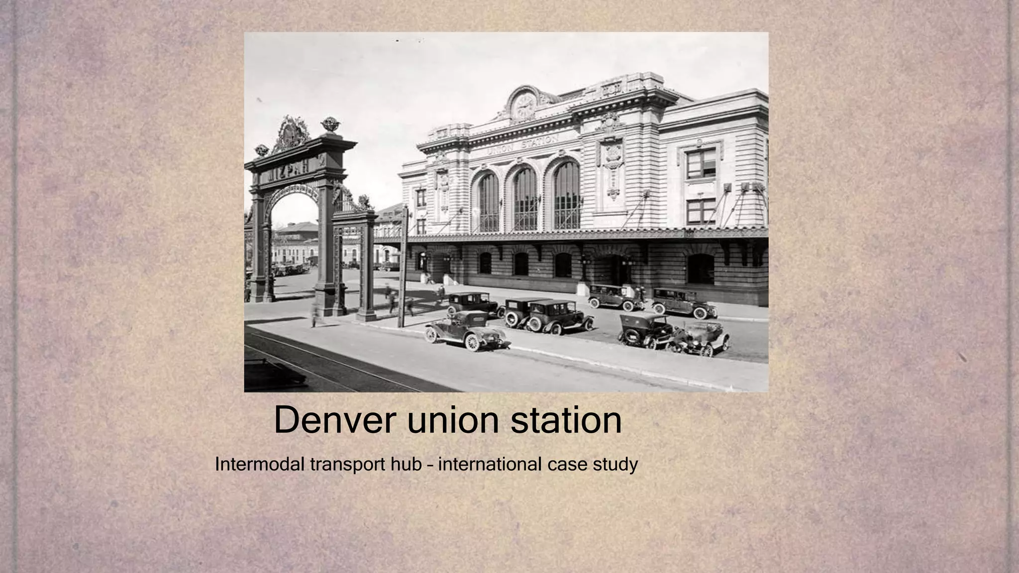
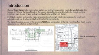
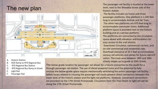
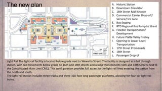
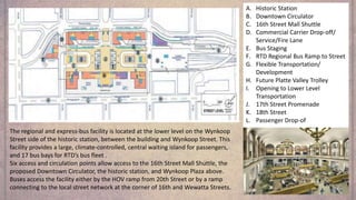
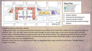
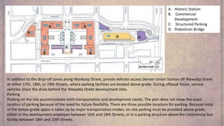
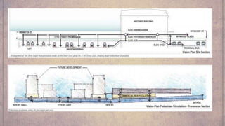
Intermodal transport hub – an international case study
Denver Union Station is the main railway station and central transportation hub in Denver, Colorado. It is located at 17th and Wynkoop Streets in the present-day LoDo district and includes the historic terminal building, a train shed, a 22-gate underground bus facility, and light rail station.
In 2012, the station underwent a major renovation transforming it into the centerpiece of a new transit-oriented mixed-use development built on the site's former railyards.
The station house re-opened in the summer of 2014 as a combination of the 112-room Crawford Hotel, several restaurants and retails and a dining hall.
4. Site plan - detailed
A. Historic Station
B. HOV Ramp to RTD Regional Bus
C. RTD Regional Bus Station
D. RTD Regional Bus Ramp to Street
E. Light Rail
F. Passenger Rail
5. Introduction
Denver Union Station is the main railway station and central transportation hub in Denver, Colorado. It is
located at 17th and Wynkoop Streets in the present-day LoDo district and includes the historic terminal
building, a train shed, a 22-gate underground bus facility, and light rail station.
In 2012, the station underwent a major renovation transforming it into the centerpiece of a new transit-
oriented mixed-use development built on the site's former railyards.
The station house re-opened in the summer of 2014 as a combination of the 112-room Crawford Hotel, several
restaurants and retailers, and a train hall.
(site & surroundings )
6. the new proposal and the new multimodal terminal
(2001-2016)
The Denver Union Station Master Plan presents a vision, a framework,
and practical guidelines to transform the historic station into a
multimodal transportation center serving the Denver region and the
entire state of Colorado. The multimodal concept brings together
many different means of transportation in one place with logical, safe,
and convenient transfers.
The Master Plan expands this concept to include international
connections through DIA and private international bus connections.
And it restores the station as a gateway to Colorado, the metropolitan
region, and Downtown Denver.
By combining all the region’s transportation modes at one hub, Denver
Union Station will enhance the value of local, regional, state, and
federal investments in highways, HOV lanes, light rail, commuter rail,
local and regional buses, parking, bike paths, and pedestrian networks
.
7. Because of its rugged geography, the population density of established communities, a
fragile environmental landscape, limited fi nancial resources, and a growing desire among
citizens for increased transportation choices, Colorado’s current transportation needs
require more than highway expansion.
As the state’s population grows to a projected 7 million by 2030, Colorado will need
transportation alternatives to keep people and goods fl owing. Denver Union Station
provides the premier access and transfer point for transportation that will serve the
region, the state, and beyond.
In the 1990s, Denver, CDOT, DRCOG, and RTD joined as partners in planning a multimodal
transportation hub at Denver Union Station.
These efforts, in conjunction with the planning and partial implementation of the
regional transportation system, led to RTD’s 2001 purchase of the site, as part of a jointly
funded acquisition with intergovernmental participation by the public agency partners. In
a spirit of unprecedented cooperation, these agencies now share a common vision for
the future of Denver Union Station
the reason behind the new plan
8. To connect transportation modes, the public circulation system needs to be easy to
understand and have convenient connections. The main orientation and connection area
is the public circulation on the 17th Street axis between Wynkoop and Wewatta streets.
All connections to the major transportation modes can be made along this axis.
The historic station serves as the main orientation feature for pedestrians on the site. The
17th Street Promenade on Wewatta Street connects the passenger-rail and light-rail
platforms to the station and with the public and commercial transportation services that
distribute passengers throughout the region.
It also includes escalators and elevators, drop-off points for taxis, limousines, and
shuttles, the 16th Street Mall Shuttle and proposed Downtown Circulator stops, and
retail and vendor kiosks.
Public and pedestrian circulation
9. Area context
For most of Denver Union Station’s history, the site has held the western edge of
Downtown’s warehouse district. In the last 15 years, the mercantile warehouses
of the Lower Downtown Historic District (LoDo) have been rejuvenated with
residences, galleries, restaurants, shopping, and entertainment. Downtown,
LoDo, and surrounding neighborhoods now contain more than 11,000 residents.
Major sports and entertainment venues around LoDo have turned the entire
area into a regional attraction.
The site is at the western end of the 16th Street Mall, with a strong connection
to Central Business District employment. Just three blocks north, Coors Field has
spurred new residential and commercial development north and east of the
station.
To the south and west, the new Commons Neighborhood is emerging on former
railyards in the Central Platte Valley. The historic Highlands Neighborhood is
further west , featuring spectacular views of the Denver Union Station site and
Downtown. Six blocks south is Larimer Square, Denver’s first historic district. The
Pepsi Center and Invesco Field at Mile High are located one-half mile and one
and one-half miles south and west, respectively. walking distances from
various important landmarks
10. The new plan
A. Historic Station
B. HOV Ramp to RTD Regional Bus
C. RTD Regional Bus Station
D. RTD Regional Bus Ramp to Street
E. Light Rail
F. Passenger Rail
The passenger-rail facility is located at the lower
level, next to the Wewatta Street side of the
historic station.
The facility includes six tracks and three
passenger platforms. One platform is 1,540 feet
long to accommodate Amtrak and Ski Train.
The other two platforms are 970 feet long to
accommodate commuter trains. Additional
platform space is provided next to the historic
building and at a service platform.
The platforms are connected to the circulation
space above with elevators and escalators for
easy access to the mall shuttle,
Downtown Circulator, commercial carriers, and
on-site commercial and residential uses.
Overhead clearance of 20.5 feet accommodates
various rail vehicles and allows for future electrifi
cation. The track area between 18th and 20th
streets slopes up to grade at 20th Street.
The below-grade location for passenger rail allows for a future connection to the south for a
through-passenger rail station. The use of diesel-powered trains and the potential to fully
enclose the below-grade space require mechanically ventilating the entire passenger-rail facility.
Safety issues related to crossing the passenger-rail tracks prevent direct connection between the
lower level of the historic station and the light-rail platforms. However, convenient connections
are provided via the 17th Street Promenade. Circulation from the Train Room to light rail will be
along the 17th Street Promenade.
11. The new plan A. Historic Station
B. Downtown Circulator
C. 16th Street Mall Shuttle
D. Commercial Carrier Drop-off/
Service/Fire Lane
E. Bus Staging
F. RTD Regional Bus Ramp to Street
G. Flexible Transportation/
Development
H. Future Platte Valley Trolley
I. Opening to Lower Level
Transportation
J. 17th Street Promenade
K. 18th Street
L. Passenger Drop-of
Light Rail The light-rail facility is located below grade next to Wewatta Street. The facility is designed as a full through
station, with rail movements below grade on 16th and 18th streets and a loop that connects 16th and 18th Streets next to
the Consolidated Main Line (CML). This confi guration provides full access to the light-rail lines entering the station from
the north and south.
The light-rail station includes three tracks and three 360-foot-long passenger platforms, allowing for four-car light-rail
trains.
12. A. Historic Station
B. Downtown Circulator
C. 16th Street Mall Shuttle
D. Commercial Carrier Drop-off/
Service/Fire Lane
E. Bus Staging
F. RTD Regional Bus Ramp to Street
G. Flexible Transportation/
Development
H. Future Platte Valley Trolley
I. Opening to Lower Level
Transportation
J. 17th Street Promenade
K. 18th Street
L. Passenger Drop-of
The regional and express-bus facility is located at the lower level on the Wynkoop
Street side of the historic station, between the building and Wynkoop Street. This
facility provides a large, climate-controlled, central waiting island for passengers,
and 17 bus bays for RTD’s bus fleet .
Six access and circulation points allow access to the 16th Street Mall Shuttle, the
proposed Downtown Circulator, the historic station, and Wynkoop Plaza above.
Buses access the facility either by the HOV ramp from 20th Street or by a ramp
connecting to the local street network at the corner of 16th and Wewatta Streets.
13. A. Historic Station
B. Commercial Development
C. Commercial Bus Facility
D. Commercial Bus Facility Package
Express
Pedestrian, Bicycle, and Other Modes
Simple, convenient, and efficient pedestrian movements are critical to the Vision Plan. Pedestrians can enter the facility at
grade at 16th, 17th, and 18th Streets and can pass through the site at these axes, or can move between 16th and 18th
Streets either at Wynkoop Plaza or along the west side of the historic station. This network of pedestrian routes provides
easy circulation to transportation modes, to future development spaces within the historic station, and to connections
with LoDo and the Commons Neighborhood.
Bicyclists access the site from Wynkoop and 16th, on designated bike routes, and from local streets. The Bike Station
location is fl exible.
14. A. Historic Station
B. Commercial
Development
C. Structured Parking
D. Pedestrian Bridge
In addition to the drop-off zones along Wynkoop Street, private vehicles access Denver Union Station off Wewatta Street
at either 17th, 18th, or 19th Streets, where parking facilities are located above grade. During offpeak hours, service
vehicles share the drive behind the Wewatta Street development sites.
Parking
Parking on the site accommodates both transportation and development needs. The plan does not show the exact
location of parking because of the need for future flexibility. There are three possible locations for parking. Because most
of the below-grade space is taken up by major transportation modes, on-site parking must be provided above-grade,
either in the development envelopes between 16th and 18th Streets, or in a parking structure above the commercial bus
facility between 18th and 20th Streets.