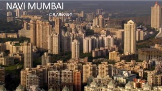
Navi Mumbai is a planned city located across Mumbai Harbour and was conceived to ease population density and infrastructure issues in Mumbai. It consists of 12 nodal townships planned along transit corridors to promote decentralization. The nodal approach and emphasis on public transport has made Navi Mumbai polycentric in nature. Key aspects of its planning included creating living spaces, establishing mass transit systems, and following principles of decentralization and single-use zoning.
INTRODUCTION
COORDINATES - 23.22 ON 72.680 E ELEVATION - 265 feet (81 m)*
LOCATED 23 KM NORTH OF AHEMDABAD (FIN CAP. OF GUJARAT)
PLANNED IN 1960S BY, PRAKASH M APTE & H. K. MEWADA,
AFTER PARTITION OF BOMBAY * STATE : AHEMDABAD WAS MADE AS THE CAPTAL OFGUJARAT
AREA TOTAL 177KM2 ELEVATION : 8IM ( 266 FT)
POPULATION (2011)
TOTAL: 206,167 DENSITY : 1,200/KM2
CLIMATE*
TROPICAL WET AND DRY CLIMATE•
SUMMER MAXIMUM - 36 to 42 °C MINIMUM - 19 to 27 C
WINTER MAXIMUM - 29 C MINIMUM - 14°C
MONSOON: THE AVERAGE ANNUAL RAINFALL IS AROUND 803.4 MM
LANGUAGES
GUJARATI, HINDI, AND ENGLISH• 54% GREEN COVER ON ITS LAND AREA
• THE CITY SITS ON THE BANKS OF THE SABARMATI RIVER, IN NORTH-CENTRALEAST GUJARAT
HISTORY
IN 1960, THE INDIAN STATE OF BOMBAY WAS SPLIT INTO TWO STATES, MAHARASHTRA AND GUJARAT LEAVING GUJARAT WITHOUT A CAPITAL CITY.
AT THE TIME AHMEDABAD WAS SELECTED TO BE THE FIRST CAPITAL OF THE NEWLY CREATED STATE.
• IT WAS LATER PROPOSED THAT A NEW CAPITAL CITY BE CONSTRUCTED FOR THE STATE.
• GANDHINAGAR GOT AN IDENTITY OF ITS OWN WHEN THE STATE OF MUMBAI WAS DIVIDED INTO TWO SEPARATE STATES OF GUJARAT AND MAHARASHTRA.
• IN THE BEGINNING, AHMEDABAD - A COMMERCIAL HUB OF GUJARAT WAS CHOSEN AS THE STATE CAPITAL AND IT WAS PROPOSED THAT A NEW CAPITAL SHOULD BE CONSTRUCTED ALONG THE LINE OF OTHER NEW STATE CAPITALS, PARTICULARLY CHANDIGARH
• THEREFORE TWO WELL-KNOWN INDIAN ARCHITECTS, H.K. MEWADA AND PRAKASH M. APTE (WHO WORKED AS BEGINNER FOR THE CHANDIGARH CITY) DESIGNED THE NEW STATE CAPITAL*
NAMED AFTER MAHATMA GANDHI THE FOUNDATION STONE OF THIS CITY WAS LAID ON 1965 AND IN 1971 THE CAPITAL WAS SHIFTED FROM AHMEDABAD TO GANDHINAGAR
PLANNING
• PLANNED AND IMPLEMENTED BETWEEN 1965-1970
• DETERMINATION TO MAKE GANDHINAGAR A PURELY INDIAN ENTERPRISE, PARTLY BECAUSE GUJARAT WAS THE BIRTHPLACE OF GANDHI.
• TO ESTABLISH AND MAINTAIN A SEPARATE IDENTITY FOR THE NEW CITY THE SURROUNDING AREA OF ABOUT 39 VILLAGES WAS BROUGHT UNDER A PERIPHERY CONTROL ACT (AS IN CHANDIGARH)
• THE AREA LATER CONSTITUTED A SEPARATE ADMINISTRATIVE DISTRICT OF GANDHINAGAR.
• THE CITY WAS PLANNED FOR A POPULATION OF 150,000 BUT CAN ACCOMMODATE DOUBLE THAT POPULATION WITH INCREASE IN THE FLOOR SPACE RATIO FROM 1 TO 2 IN THE AREAS RESERVED FOR PRIVATE DEVELOPMENT.
• THE RIVER BEING THE BORDER ON THE EAST, AND THE INDUSTRIAL AREA TO THE NORTH, THE MOST LOGICAL FUTURE PHYSICAL EXPANSION OF THE CITY WAS ENVISAGED TOWARDS THE NORTH-WEST
Urban Design-Literature study St. Marks Road, BangaloreAnsh Agarwal
Urban Planning
Literature study of St. Marks Road, Bangalore.
Includes:
1. Road Details
2. Survey Details & Analysis
3. Action Needed
4. Proposals
5. Action Made
6. Before & After Scenerio
7. Anatomy of Changes
This modular housing based in Belapur, New Mumbai, is designed by Ar. Charles Correa. This project, which was constructed in the 1980s, stands as a perfect example of affordable and high density housing, which is the need of the hour.
Navi Mumbai is the world's largest planned city.pdfyamunaNMH
The twin city of Mumbai is also known as Navi Mumbai. This city, which is located in the western suburbs of Mumbai, was conceptualize by renowned urban planner and architect Charles Correa, structural engineer Pravina Mehta, and engineer Shirish Patel. Navi Mumbai, a recently built township, is a well-planned city with a strong infrastructure for its period.
APLI Mumbai - A Port Lands Initiative By Citizens To Re-Imagine Mumbaiapliportlands
The re-development of the Port Lands offers a unique
opportunity to re-invent our city by creating the much
needed public infrastructure, utilities and public spaces
that we are so short of.
Of the total holding by Mumbai Port Trust of 734 ha, the
land available for development is approx 400 ha (1000
acres) excluding the Docks and operational areas (196
ha) and residential areas ( approx 100 ha). A legislative
framework to enable these lands to be re-possessed and
a financial model to re-develop these lands as a public
Private partnership with Mumbai’s Industrial &Corporate
Houses using CSR funds has been proposed in Annexure 4.
Our plans integrate the Port lands, with adjacent city
areas such as Sewri, Lalbaug, Byculla, Mazagon,
Dongri and Bhendi Bazaar, and provide Mumbaikars
much needed public amenities and public open spaces
which are critical for our city’s sustainable growth, as the
commercial and entrepreneurial heart of India.
We see this as a living document and will share this
widely in the public domain. Feedback from citizens and
citizens groups will be collated and shared with you from
time to time.
Singapore, officially the Republic of Singapore, is a sovereign island city-state in Southeast Asia.
It is located at the end of the Malayan Peninsula between Malaysia and Indonesia.
Singapore has a total land area of 724.2 square kilometers.
Singapore's territory consists of one main island along with 58 other islets.
Since independence[1965], extensive land reclamation has increased its total size by 23%.
Singapore is very small in size and confined. so, there every sq. meter matters.
Now, 90% of citizens in Singapore own their houses.
Urban planning in Singapore has formulated and guided its physical development from the day Singapore was founded in 1819 as a British colony to the developed, independent country it is today.
Urban planning is especially important due to land constraints and its high density.
The Urban Redevelopment Authority (URA) is Singapore's national land-use planning authority.
URA prepares long term strategic plans, as well as detailed local area plans, for physical development, and then co-ordinates and guides efforts to bring these plans to reality.
Prudent land use planning has enabled Singapore to enjoy strong economic growth and social cohesion, and ensures that sufficient land is safeguarded to support continued economic progress and future development
In 1822, Raffles initiated a comprehensive town plan called land use plan.
This plan to guide the allocation of land in the principal town to ensure that its physical growth followed an orderly pattern.
This became known as the Raffles Town Plan, or the Jackson Plan, drawn up by Lieutenant Philip Jackson and published in 1828.
Among its key features were a GRID LAYOUT for the road network and a clear segregation of residential communities by ethnic group (European, Chinese, Indian, Malay and Arab).
A separate area called Commercial Square (later renamed Raffles Place) was designated for commercial activities and another area was zoned for government functions.
Raffles Place and the street pattern of the city Centre
today are evidence of this colonial legacy.
This presentation contains my internship project work for a feasibility study in the locales of Kalyan-Dombivli and Ambernath-Badlapur.
The report has been compiled by Secondary and Primary research over a tenure of 8 weeks.
The Mumbai Metropolitan Region extends over an area of 4355 sq. km and comprises Municipal Corporations of Greater Mumbai, Thane, Kalyan, Navi Mumbai and Ulhasnagar; 15 municipal towns; 7 non-municipal urban centers; and 995 villages. Its administrative limits cover Mumbai City and Mumbai Suburban Districts, and parts of Thane and Raigad District. There are 40 Planning Authorities in the Region that are responsible for the micro-level planning of the different areas.
ELEMENTS AND PRINCIPLES OF TOWN PLANNING WITH THE MODELS PROPOSED FOR TOWN PLANNING VIZ CONCENTRIC ZONE THEORY, SECTOR MODEL THEORY AND MULTIPLE NUCLEI MODEL. ADDITIONALLY THE URBAN FORMS OD THE CITIES.
CFD Simulation of By-pass Flow in a HRSG module by R&R Consult.pptxR&R Consult
CFD analysis is incredibly effective at solving mysteries and improving the performance of complex systems!
Here's a great example: At a large natural gas-fired power plant, where they use waste heat to generate steam and energy, they were puzzled that their boiler wasn't producing as much steam as expected.
R&R and Tetra Engineering Group Inc. were asked to solve the issue with reduced steam production.
An inspection had shown that a significant amount of hot flue gas was bypassing the boiler tubes, where the heat was supposed to be transferred.
R&R Consult conducted a CFD analysis, which revealed that 6.3% of the flue gas was bypassing the boiler tubes without transferring heat. The analysis also showed that the flue gas was instead being directed along the sides of the boiler and between the modules that were supposed to capture the heat. This was the cause of the reduced performance.
Based on our results, Tetra Engineering installed covering plates to reduce the bypass flow. This improved the boiler's performance and increased electricity production.
It is always satisfying when we can help solve complex challenges like this. Do your systems also need a check-up or optimization? Give us a call!
Work done in cooperation with James Malloy and David Moelling from Tetra Engineering.
More examples of our work https://www.r-r-consult.dk/en/cases-en/
Vaccine management system project report documentation..pdfKamal Acharya
The Division of Vaccine and Immunization is facing increasing difficulty monitoring vaccines and other commodities distribution once they have been distributed from the national stores. With the introduction of new vaccines, more challenges have been anticipated with this additions posing serious threat to the already over strained vaccine supply chain system in Kenya.
Automobile Management System Project Report.pdfKamal Acharya
The proposed project is developed to manage the automobile in the automobile dealer company. The main module in this project is login, automobile management, customer management, sales, complaints and reports. The first module is the login. The automobile showroom owner should login to the project for usage. The username and password are verified and if it is correct, next form opens. If the username and password are not correct, it shows the error message.
When a customer search for a automobile, if the automobile is available, they will be taken to a page that shows the details of the automobile including automobile name, automobile ID, quantity, price etc. “Automobile Management System” is useful for maintaining automobiles, customers effectively and hence helps for establishing good relation between customer and automobile organization. It contains various customized modules for effectively maintaining automobiles and stock information accurately and safely.
When the automobile is sold to the customer, stock will be reduced automatically. When a new purchase is made, stock will be increased automatically. While selecting automobiles for sale, the proposed software will automatically check for total number of available stock of that particular item, if the total stock of that particular item is less than 5, software will notify the user to purchase the particular item.
Also when the user tries to sale items which are not in stock, the system will prompt the user that the stock is not enough. Customers of this system can search for a automobile; can purchase a automobile easily by selecting fast. On the other hand the stock of automobiles can be maintained perfectly by the automobile shop manager overcoming the drawbacks of existing system.
Democratizing Fuzzing at Scale by Abhishek Aryaabh.arya
Presented at NUS: Fuzzing and Software Security Summer School 2024
This keynote talks about the democratization of fuzzing at scale, highlighting the collaboration between open source communities, academia, and industry to advance the field of fuzzing. It delves into the history of fuzzing, the development of scalable fuzzing platforms, and the empowerment of community-driven research. The talk will further discuss recent advancements leveraging AI/ML and offer insights into the future evolution of the fuzzing landscape.
Water scarcity is the lack of fresh water resources to meet the standard water demand. There are two type of water scarcity. One is physical. The other is economic water scarcity.
Immunizing Image Classifiers Against Localized Adversary Attacksgerogepatton
This paper addresses the vulnerability of deep learning models, particularly convolutional neural networks
(CNN)s, to adversarial attacks and presents a proactive training technique designed to counter them. We
introduce a novel volumization algorithm, which transforms 2D images into 3D volumetric representations.
When combined with 3D convolution and deep curriculum learning optimization (CLO), itsignificantly improves
the immunity of models against localized universal attacks by up to 40%. We evaluate our proposed approach
using contemporary CNN architectures and the modified Canadian Institute for Advanced Research (CIFAR-10
and CIFAR-100) and ImageNet Large Scale Visual Recognition Challenge (ILSVRC12) datasets, showcasing
accuracy improvements over previous techniques. The results indicate that the combination of the volumetric
input and curriculum learning holds significant promise for mitigating adversarial attacks without necessitating
adversary training.
Sachpazis:Terzaghi Bearing Capacity Estimation in simple terms with Calculati...Dr.Costas Sachpazis
Terzaghi's soil bearing capacity theory, developed by Karl Terzaghi, is a fundamental principle in geotechnical engineering used to determine the bearing capacity of shallow foundations. This theory provides a method to calculate the ultimate bearing capacity of soil, which is the maximum load per unit area that the soil can support without undergoing shear failure. The Calculation HTML Code included.
Welcome to WIPAC Monthly the magazine brought to you by the LinkedIn Group Water Industry Process Automation & Control.
In this month's edition, along with this month's industry news to celebrate the 13 years since the group was created we have articles including
A case study of the used of Advanced Process Control at the Wastewater Treatment works at Lleida in Spain
A look back on an article on smart wastewater networks in order to see how the industry has measured up in the interim around the adoption of Digital Transformation in the Water Industry.
2. • Formerly Bombay, is the commercial and
financial centre of India, with a
population of about twelve million at 2010.
• Mumbai is built on what was once a set
of seven islands: Bombay
Island, parel, Mazagaon, mahim, colaba, w
orli, and Old Woman's Island(also known
as Little Colaba).
• The seven islands coalesced into a single
landmass by the Hornby Vellard project via
large scale land reclamation(1845).
• The huge city is growing by many thousand
hopeful immigrants from predominantly
rural areas each day.
• Mumbai‘s particular topography – it is a long, narrow peninsula –
meant that the constantly needed extension of the city limits was
possible in one direction only, northwards.
HISTORY AND NEED FOR NEW CITY
3. • Britain‘s efforts as a colonial power 200 years
ago were directed at citifying something that
was essentially a withdrawn little town
because of its outstanding location as a
harbor and trading center.
• But Bombay did not flourish until 50 years later, when the turmoil of the Civil War cut off
American cotton export. So the world focused its interest on Indian cotton, and Bombay
became the center for the shipment of goods.
• Ultra-fast growth began, the port became the largest in India, and rapid urban expansion
created the problem of a housing shortage and a proliferation of emergency accommodation.
• The center of Mumbai, now and then, is at the southern end of the peninsula, where
commercial life developed and population density and land prices are highest.
• The extreme expansion of the urban area to one side of a fixed commercial center created
Mumbai‘s major problems of long transport routes. Journeys lasting several hours on
express trains had to be accepted if people were to get to work, a state of affairs that
eventually reached its natural limits.
• Bombay’s population jumped from 1.5 million in the years leading up to the Second World War
to 4.5 million in 1964, and was predicted to double by 1984.
4. • As early as 1964, Bombay municipality published the draft plan
to deal with population growth for next two decades and invited
the public comments and suggestions from the public.
• Charles Correa with his colleagues Pravina Mehta and Shiresh
Patel proposed to the Mumbai city authorities that they should
not expand any further northwards, but use an eastern site cut
off by a sea bay for urban expansion, with the aim of
establishing New Mumbai.
• The government did not finally accept this plan until 1970,
when it started to buy land east of Mumbai old town.
• Large bridges then made it possible to create a direct link with
the old centre, so that there was now nothing else in the way of
the actual goal of a new commercial centre with a new
urban structure.
• The City and Industrial Development Corporation (CIDCO) was
founded, and Charles Correa headed it as chief architect from
1970 to 1974.
• Their aim was to settle at least four million people in New
Mumbai, thus containing the spread of further emergency
accommodation and creating enough new jobs.
5. NAVI MUMBAI - INTRODUCTION
• The prominent authors of the twin city concept
were Charles Correa (architect and urban
designer) , Pravina Mehta(structural engineer)
and Shirish Patel(engineer and planner) who
presented to the government a proposal in 1964
for constructing new growth centers across
Bombay harbor on the mainland.
• Navi Mumbai covers an area of 344 sq. km.
• The site that was finally chosen was across the harbor from Bombay island. It is a
narrow piece of land bounded by the Western Ghat mountain ranges on the north,
south and east, and the Arabian Sea on the west.
• There were two key aspects to be dealt with:
• creating living space and
• setting up mass transport systems.
6. NAVI MUMBAI – CONCEPT
• The success of Navi Mumbai lies in the approach
adopted while it’s planning. Considering the massive
scale of Navi Mumbai project and to avoid a Mumbai
like situation of activity concentration caused by a
mono-centric development model, the planners
adopted polycentric nodal pattern of development.
• The polycentric approach based on principle of
decentralization.
• It avoids concentration of population, and activities in
a particular area rather it works like ‘bunch of grapes’
and focused on decentralization and balance
distribution of residential areas, job centers, wholesale
markets, non polluting industries and population
density and other activities in different nodes / areas of
the city.
• The pattern ensured balanced land and even
distribution of residential areas, job centres, wholesale
markets, non-polluting industry and population density.
• The 12 self-contained nodal townships are strung
along the mass rapid transport corridors, designed to
minimise travel time and distance between nodes and
neighbouring cities.
7. • The conceptual design of Navi Mumbai was developed at a height of
modernism,
• The principles were
• Decentralization by the design of self sufficient townships (nodes).
• Residential neighborhoods (sectors)
• Single use zoning as opposed to traditional multiple use zoning.
• The total area of Navi Mumbai was divided into townships. Each township has several
sectors. Many were residential in nature.
• Each node was planned to accommodate a range of some income groups.
• Ponds were created to accumulate excess run off.
• Each node is self-contained for 100,000 to 200,000 people.
• The nodes contain residential, commercial, infrastructure and recreational uses.
At a larger scale, nodes share some common facilities such as water reservoirs
and transport facilities.
• Navi Mumbai has the SEZ zone spread over an area of 2,140 Ha across 3 nodes
of Navi Mumbai, Functioning as a deemed foreign territory.
NAVI MUMBAI – DESIGN PRICIPLES
8. MRT CORRIDOR
• The structural plan of New Bombay: three
linear spines arranged in a pinwheel
around the CBD(Central Business District)
at one end tied to the regional transport
network at the other, anchoring the new
city into the surrounding region.
• With developments in road, rail, air and
water transport, Navi Mumbai is fully
equipped to cater the needs of the
commuters.
• Part of this is the suburban trains that
connect to 12 nodes to each other as well
as to Mumbai.
9. EVOLUTION OF TRANSPORT SYSTEM
• The linear pattern of Mumbai is
better for a mass transport
system because it creates a
corridor of demand and thus an
efficient bus system.
• The system grows with a series of
sectors which pop up based on
the growth of the specific locality,
all mushroomed with bus lines.
Thus it also helps in the
development of the hinterlands.
• With the development of the
MRT, there also comes an
additional MRT which could help
with the further development of
the sectors.
• With the starting of a simple bus
line, gradually a complex
network of buses and trains can
be built, transgressing the
cost/capacity constraints.
11. • Airoli Node
• Airoli is one of the good nodes developed in initial years by CIDCO(City and Industrial Development
Corporation).It was taken up for development during 1983-84.
• The main intention of its development to provide housing facilities to the people working.
• Airoli is located on northern tip of Navi Mumbai.
• This node has good connectivity with Mumbai through Mulund – Airoli bridge. It is also well connected
with another city Thane through railway as well as by road.
• Ghansoli Node
• The development of this node was started around 1993; the focus was to provide affordable housing to
the people working in the nearby industries.
• Located South of Airoli node.
• It is also well connected with another city Thane through railway as well as by road and with Mumbai
through Mulund – Airoli bridge.
• Kopar Khairane Node
• It is adjacent to the industrial area and Vashi. Development of this node was started in 1986.
• Kopar Khairane is also known as extended suburb of the Vashi.
• The node is well connected by train as well as road.
• Located south to Ghansoli.
• Vashi Node
• Vashi was the first node taken up for development by CIDCO. Often it is called as King of Navi Mumbai.
• Vashi is located just across the Thane creek bridge on the mainland.
• The development was started immediately after opening of Thane Creek Bridge in 1972.
• Vashi is the commercial hub of Navi Mumbai.
12. • Sanpada Node
• The combine development of Vashi-Sanpada node was started in 1972.
• The node is well connected by railway and road.
• Sanpada is coming up as better place for business expansion.
• Nerul Node
• Nerul is the second best developed node after Vashi. It is often called as queen of Navi Mumbai.
• The node is predominantly residential node.
• The node was taken up for development in 1981.
• CBD Belapur Node
• This node is located in the heart of the city, so planners decided to make the ‘Central Business
District’ of the city in this node.
• The north side is exclusively planned for residential use whereas south side is planned for
commercial/mercantile/office uses.
• Kharghar and taloja Node
• Kharghar is the futuristic node of Navi Mumbai it was started developing around 1988-89.
• One of the most artistically-designed nodes of Navi Mumbai, with novel concepts, ideas and
system forming the cornerstone of the nodes development.
• It often termed as Model
• Township of the city.
13. • Kalamboli and Kamothe Node
• Kalamboli is one of the busiest nodes in Navi Mumbai.
• Kamothe is one of the developing nodes of Navi Mumbai. It was started developing in 2000.
• CIDCO have started developing steel market and warehousing complex by 1979-80 and residential complex
by 1982.
• This node is also part of Navi Mumbai Special Economic Zone.
• New Panvel Node
• This is also one of the developing nodes of Navi Mumbai. Development of this node was started in 1975-76.
• Panvel is an important railway station on Konkan Railway.
• This node is still maintained and managed by CIDCO.
• Ulwe
• Ulwe node is located on south of CBD Belapur across the creek. Development of this node is already started.
• This node is part of Navi Mumbai Special Economic Zone and is adjacent to proposed Navi Mumbai
International Airport.
• Ulwe is upcoming node of Navi Mumbai and its information till 2010 is not reported.
• Dronagiri Node
• Dronagiri node is the largest node planned by CIDCO
• Due to its topography it is very difficult to develop this node.
• Its proximity to the port makes it ideal for port-based industries.
• Development of this node was started after 1989.
• This node is maintained by CIDCO.
14. Typical neighbourhood
• This shows how the public
transport is used to open
up land, making its
accessible in desired
quantities and locations.
• The open green areas and
maidans(play grounds) are
kept central to
neighbourhood with a
zone for cottage and other
small scale industries on
either side of the railway
line.