International Journal of Modern Engineering Research (IJMER) is Peer reviewed, online Journal. It serves as an international archival forum of scholarly research related to engineering and science education.
International Journal of Modern Engineering Research (IJMER) covers all the fields of engineering and science: Electrical Engineering, Mechanical Engineering, Civil Engineering, Chemical Engineering, Computer Engineering, Agricultural Engineering, Aerospace Engineering, Thermodynamics, Structural Engineering, Control Engineering, Robotics, Mechatronics, Fluid Mechanics, Nanotechnology, Simulators, Web-based Learning, Remote Laboratories, Engineering Design Methods, Education Research, Students' Satisfaction and Motivation, Global Projects, and Assessment…. And many more.
Mapping Gradex values on the Tensift basin (Morocco)IJERA Editor
The aim of this study is to elaborate the cartography of Gradex parameter used in the Gradex method for estimating flood peaks in order to size hydraulic structures. Map of spatial variation is elaborated using the geostatistical method of kriging. Several reference functions (exponential model, spherical, linear, Gaussian and cubic) were used for modeling the kriging variogram. Cross-validation enabled a comparison between the results of these models and choice of spherical model with anisotropy and trend fit by a second-order polynomial as the most suitable. The use of available series of annual maximum daily rainfall recorded at 23 rainfall stations, distributed over the Tensift basin, led also to develop the cartography of standard prediction errors‟ values associated to the predicted parameter for each point of Tensift basin. These errors vary from acceptable values (16.8%) to very high ones depending on the density of the rainfall stations at the desired site.
International Journal of Engineering and Science Invention (IJESI)inventionjournals
International Journal of Engineering and Science Invention (IJESI) is an international journal intended for professionals and researchers in all fields of computer science and electronics. IJESI publishes research articles and reviews within the whole field Engineering Science and Technology, new teaching methods, assessment, validation and the impact of new technologies and it will continue to provide information on the latest trends and developments in this ever-expanding subject. The publications of papers are selected through double peer reviewed to ensure originality, relevance, and readability. The articles published in our journal can be accessed online.
IJRET : International Journal of Research in Engineering and Technology is an international peer reviewed, online journal published by eSAT Publishing House for the enhancement of research in various disciplines of Engineering and Technology. The aim and scope of the journal is to provide an academic medium and an important reference for the advancement and dissemination of research results that support high-level learning, teaching and research in the fields of Engineering and Technology. We bring together Scientists, Academician, Field Engineers, Scholars and Students of related fields of Engineering and Technology
Mapping the anthropic backfill of the historical center of Rome (Italy) by us...Beniamino Murgante
Mapping the anthropic backfill of the historical center of Rome (Italy) by using Intrinsic Random Functions of order k (IRF-k)
Ciotoli Giancarlo, Francesco Stigliano, Fabrizio Marconi, Massimiliano Moscatelli, Marco Mancini, Gian Paolo Cavinato - Institute of Environmental Geology and Geo-engineering (I.G.A.G.), National Research Council, Italy
Internal-multiple attenuation on Encana data - Qiang Fu and Arthur B. WegleinArthur Weglein
The attenuation of internal-multiple energy on land data is currently one of the most challenging
tasks in seismic data preprocessing. In general, poor data quality and the lack of velocity
information for complicated geological structure (especially in the near surface) in land data often
result in poor predictions by the internal multiple attenuation methods requiring subsurface
information. Inverse Scattering Series (ISS) internal-multiple attenuation is a very promising
algorithm for attenuating internal-multiple energy on land seismic exploration data. The key
characteristic of the ISS-based methods is that they do not require any information about the
subsurface– i.e., they are fully data driven. Internal multiples from all possible generators are
predicted simultaneously from the input data. In this paper we apply Inverse Scattering Series
(ISS) internal- multiple-attenuation algorithms on land seismic data from Canada.
Land Cover maps supply information about the physical material at the surface of the Earth (i.e. grass, trees, bare ground, asphalt, water, etc.). Usually they are 2D representations so to present variability of land covers about latitude and longitude or other type of earth coordinates. Possibility to link this variability to the terrain elevation is very useful because it permits to investigate probable correlations between the type of physical material at the surface and the relief. This paper is aimed to describe the approach to be followed to obtain 3D visualizations of land cover maps in GIS (Geographic Information System) environment. Particularly Corine Land Cover vector files concerning Campania Region (Italy) are considered: transformed raster files are overlapped to DEM (Digital Elevation Model) with adequate resolution and 3D visualizations of them are obtained using GIS tool. The resulting models are discussed in terms of their possible use to support scientific studies on Campania Land Cover.
Performances evaluation of surface water areas extraction techniques using l...Abdelazim Negm
This presentation was presented at:
9th International Conference Interdisciplinarity in Engineering, INTER-ENG 2015, 8-9 October 2015, Tirgu-Mures, Romania
The complete paper will be published in Procedia Technology Journal soon.
IJRET : International Journal of Research in Engineering and Technology is an international peer reviewed, online journal published by eSAT Publishing House for the enhancement of research in various disciplines of Engineering and Technology. The aim and scope of the journal is to provide an academic medium and an important reference for the advancement and dissemination of research results that support high-level learning, teaching and research in the fields of Engineering and Technology. We bring together Scientists, Academician, Field Engineers, Scholars and Students of related fields of Engineering and Technology
Cost Analysis of Small Scale Solar and Wind Energy SystemsIJMER
Abstract: The recent dramatic increase in the use of
renewable energy systems leading towards competitive
markets within the various individual renewable energy
systems. The aim of this paper is to prove the hypothesis
i.e. in next few years, when the cost of the solar PV
modules come down below 1$ per Watt, small wind
turbines become more costlier because of the cost of
structures required to support the wind generator. And
also if the threat from the market is not addressed both
technically and commercially, small wind turbine
manufactures will lose the competition to solar PV module
manufactures in the near visible future. Objective of this
paper is to do cost analysis on the industry data and prove
hypothesis and to arrive at the cutoff point, where after the
generating energy from the wind is not economically
feasible. With this cost analysis, author here by alarm for
the small scale wind turbine manufactures to take
necessary measures to survive the competitive markets of
small scale renewable energy systems.
Keywords: Renewable energy, Solar PV, Wind Turbine, Curve Fitting, Cost analysis.
Optimization of Bolted Joints for Aircraft Engine Using Genetic AlgorithmsIJMER
Genetic Algorithms mimic the evolving technique of nature to better fit populations to a certain environment. Despite this technique has proved its adequacy in several fields, its application in Aerospace is still limited, mostly because of the high quantity of acceptability criteria that the design
must pass and the amount of design parameters. The presented paper explores required GA architecture’s adaptations to be applied in highly restricted systems such as those commonly found in Aerospace applications. The proposed GA was applied to the design of an Aircraft Engine’s Axial Casing bolted joint following static strength restrictions as per FAR 33 regulations. The set of Elitism,
interdependent geometric restrictions, Crossing, and Reproduction modules proved the applicability of
the presented multi-objective GA architecture under 14 restrictions for normal, limit and ultimate loads.
As it is described, the conversion is quickly achieved due to the shortage of the search space; therefore a
modified Variable Crossing per Scheme is proposed to expand the diversity of the genome to compensate
the relatively low impact of the Mutation module. Finally, the process and solutions found were compared against the traditional design process, showing the feasibility of this technique in complex applications in terms of quality of the solution and developing time.
Signal Processing Algorithm of Space Time Coded Waveforms for Coherent MIMO R...IJMER
ABSTRACT: Space-time coding (STC) has been shown to play a key role in the design of MIMO radars with closely
spaced antennas. Multiple-input–multiple-output (MIMO) radar is emerging technology for target detection, parameter
identification, and target classification due to diversity of waveform and perspective. First, it turns out that a joint waveform
optimization problem can be decoupled into a set of individual waveform design problems. Second, a number of mono-static
waveforms can be directly used in a MIMO radar system, which offers flexibility in waveform selection. We provide
conditions for the elimination of waveform cross correlation. However, the mutual interference among the waveforms may
lead to performance degradation in resolving spatially close returns. We consider the use of space–time coding (STC) to
mitigate the waveform cross-correlation effects in MIMO radar. In addition, we also extend the model to partial waveform
cross-correlation removal based on waveform set division. Numerical results demonstrate the effectiveness of STC in MIMO
radar for waveform de-correlation. This paper introduces the signal processing issued for the coherent MIMO radar without
and with STC waveforms and also studied signal processing algorithms of coherent MIMO radar with STC waveforms for
improvement of target detection and recognition performance for real life scenario.
Keywords: STC, coherent, Probability detection, MIMO and SNR.
Effective DevOps - Pittsburgh Techfest 2016Jennifer Davis
How is this for the abstract for the keynote:
DevOps is a cultural movement that changes how we look at work, values the diversity of work done, supports acceleration of realized value, and measures the effect of social and technical change. How do we harness this very powerful force to instill or perpetuate behavior, systems, and culture within an organization? This talk will explore the underlying foundation of devops, demonstrate the framing of a narrative, and stories as a catalyst for positive change.
An Overview of Clearance Optimization in Sheet Metal Blanking ProcessIJMER
Abstract: This document prescribes a model investigation the effect of potential parameters influencing the blanking
process and their interaction. The blanking process optimization carried out by using Design of Experiment (DOE), Finite
Element Method (FEM) with ANSYS Package, Simulation with ABAQUS-Explicit software, Blank soft Software and Neural
Network Simulation in order to achieve the intended model objectives.
Keywords: Blanking Process, DOE, FEM, Optimum Clearance and Simulation.
Investigation of Effects of impact loads on Framed StructuresIJMER
This research work consists of a general overview of numerical analysis and dynamic
response of framed structures under impact loading. The purpose of the work is to introduce the Finite
Element Method which is difficult while analyzing dynamic response to framed structures. Also to
introduce the Ansys software and it will also explain and discuss particular model cases subjected to
various impact loadings. With these models there will be understanding of the behavior of framed
structures showing the clear results of stress, strain and deformation developed throughout the
structures.
GPS Instrumental Biases Estimation Using Continuous Operating Receivers NetworkCSCJournals
Precise Total Electron Content (TEC) are required to produce accurate spatial and temporal resolution of Global Ionosphere Maps (GIMs). Receivers and Satellites Instrumental Biases (IBs) are one of the main error sources in estimating precise TEC from Global Positioning Systems (GPS) data. Recently, researchers are interested in developing models and algorithms to compute IBs of receivers and satellites close to those computed from the Ionosphere Associated Analysis Centers (IAAC). Here we introduce a MATLAB code called Multi Station IBs Estimation (MSIBE) to calculate satellites and codeless tracking receivers IBs from GPS data. MSIBE based on spherical harmonic function and geometry free combination of GPS carrier phase and pseudo-range code observations and weighted least square were applied to solve observation equations, to improve estimation of IBs values. There are many factors affecting estimated value of IBs. The premier factor is the observations weighting function which relying on the satellite elevation angle. The second factor concerned with estimating IBs using single GPS Station Precise Point Positioning (PPP) or using GPS network. The third factor is the number of GPS receivers in the network. Results from MSIBE were evaluated and compared with data from IAAC and other codes like M_DCB and ZDDCBE. The results of weighted (MSIBE) least square shows an improvement for estimated IBs, where mean differences from CODE less than 0.746 ns. IBs estimated from Continuous Operating Receivers (CORs) GPS network shows a good agreement with IAAC than IBs estimated from PPP where the mean differences are less than 0.1477 ns and 1.1866 ns, respectively. The mean differences of computed IBs improved by increasing number of GPS stations in the network.
DUAL BAND GNSS ANTENNA PHASE CENTER CHARACTERIZATION FOR AUTOMOTIVE APPLICATIONSjantjournal
High-accuracy Global Navigation Satellite System (GNSS) positioning is a prospective technology that will be used in future automotive navigation systems. This system will be a composite of the United States' Global Positioning System (GPS), the Russian Federation's Global Orbiting Navigation Satellite System (GLONASS), China Beidou Navigation Satellite System (BDS) and the European Union’s Galileo. The major improvement in accuracy and precision is based on (1) multiband signal transmitting, (2) carrier phase correction, (3) Real Time Kinematic (RTK). Due to the size and high-cost of today’s survey-grade antenna solutions, this kind of technology is difficult to use widely in the automotive sector. In this paper, a low-cost small size dual-band ceramic GNSS patch antenna is presented from design to real sample. A further study of this patch antenna illustrates the absolute phase center variation measured in an indoor range to achieve a received signal phase error correction. In addition, this low-cost antenna solution is investigated when integrated into a standard multi-band automotive antenna product. This product is evaluated both on its own in an indoor range and on a typical vehicle roof at an outdoor range. By using this evaluation file to estimate the receiver position could achieve phase motion error-free result.
DUAL BAND GNSS ANTENNA PHASE CENTER CHARACTERIZATION FOR AUTOMOTIVE APPLICATIONSjantjournal
High-accuracy Global Navigation Satellite System (GNSS) positioning is a prospective technology that will
be used in future automotive navigation systems. This system will be a composite of the United States'
Global Positioning System (GPS), the Russian Federation's Global Orbiting Navigation Satellite System
(GLONASS), China Beidou Navigation Satellite System (BDS) and the European Union’s Galileo. The
major improvement in accuracy and precision is based on (1) multiband signal transmitting, (2) carrier
phase correction, (3) Real Time Kinematic (RTK). Due to the size and high-cost of today’s survey-grade
antenna solutions, this kind of technology is difficult to use widely in the automotive sector. In this paper, a
low-cost small size dual-band ceramic GNSS patch antenna is presented from design to real sample. A
further study of this patch antenna illustrates the absolute phase center variation measured in an indoor
range to achieve a received signal phase error correction. In addition, this low-cost antenna solution is
investigated when integrated into a standard multi-band automotive antenna product. This product is
evaluated both on its own in an indoor range and on a typical vehicle roof at an outdoor range. By using
this evaluation file to estimate the receiver position could achieve phase motion error-free result.
Surveying for Civil engineering is a
particular type of surveying known as "land surveying", it is the
detailed study or inspection, as by gathering information through
observations, measurements in the field, questionnaires, or
research of legal instruments, and data analysis in the support of
planning, designing, and establishing of property boundaries.
Land surveying can include associated services such as mapping
and related data accumulation, construction layout surveys,
precision measurements of length, angle, elevation, area, and
volume, as well as horizontal and vertical control surveys, and
the analysis and utilization of land survey data. Surveyors use
various tools to do their work successfully and accurately, such
as total stations, robotic total stations, GPS receivers, prisms, 3D
scanners, radio communicators, handheld tablets, digital levels,
and surveying software.
Survey data can be directly entered into a GIS from digital
data collection systems on survey instruments. When data is
captured, the user should consider if the data should be captured
with either a relative accuracy or absolute accuracy, since this
could not only influence how information will be interpreted but
also the cost of data captured.
In this paper GIS maps were developed depending on the
field surveying data made for a two traverses. First one has ribs
less than 50m length and the other larger than 50m. Each
traverse is holding five times using five equipments and
instruments: Tape, Level, Digital level, Digital theodolite and
Laser tape. Also those maps were drawn by using both of ACAD
and ArcView softwares. Then a detail surveying map was
produced. The precision was computed for both traverses in each
method. Its value is range from 1/140 to 1/10000.
GPS Datum Conversion and Improvement in GPS Accuracyijsrd.com
GPS Positioning has numerous applications in the field of navigation and Geodesy.GPS positioning is mainly based on the different Geodetic Datum. This paper mainly discusses the improved datum conversion equations for the conversion of World Geodetic System (WGS-84) to Universal Transverse Mercator (UTM), vice versa and the reduction of errors introduced while datum conversion. By applying the different filters like Least Squares Algorithm (LSA), Kalman Filter (KF) and Modified Kalman Filter (MKF) a considerable improvement in consistency has been observed. Comparatively Modified Kalman Filter gives better accuracy in positioning.GPS coordinates data samples are collected in different environments like heavy traffic area, tall buildings area are taken to validate the results.
Vehicle positioning in urban environments using particle filtering-based glob...IJECEIAES
This article presents a new method for land vehicle navigation using global positioning system (GPS), dead reckoning sensor (DR), and digital road map information, particularly in urban environments where GPS failures can occur. The odometer sensors and map measure can be used to provide continuous navigation and correct the vehicle location in the presence of GPS masking. To solve this estimation problem for vehicle navigation, we propose to use particle filtering for GPS/odometer/map integration. The particle filter is a method based on the Bayesian estimation technique and the Monte Carlo method, which deals with non-linear models and is not limited to Gaussian statistics. When the GPS sensor cannot provide a location due to the number of satellites in view, the filter fuses the limited GPS pseudo-range data to enhance the vehicle positioning. The developed filter is then tested in a transportation network scenario in the presence of GPS failures, which shows the advantages of the proposed approach for vehicle location compared to the extended Kalman filter.
Similar to Development of Methodology for Determining Earth Work Volume Using Combined Static and Kinematic GPS Observations (20)
A Study on Translucent Concrete Product and Its Properties by Using Optical F...IJMER
- Translucent concrete is a concrete based material with light-transferring properties,
obtained due to embedded light optical elements like Optical fibers used in concrete. Light is conducted
through the concrete from one end to the other. This results into a certain light pattern on the other
surface, depending on the fiber structure. Optical fibers transmit light so effectively that there is
virtually no loss of light conducted through the fibers. This paper deals with the modeling of such
translucent or transparent concrete blocks and panel and their usage and also the advantages it brings
in the field. The main purpose is to use sunlight as a light source to reduce the power consumption of
illumination and to use the optical fiber to sense the stress of structures and also use this concrete as an
architectural purpose of the building
Developing Cost Effective Automation for Cotton Seed DelintingIJMER
A low cost automation system for removal of lint from cottonseed is to be designed and
developed. The setup consists of stainless steel drum with stirrer in which cottonseeds having lint is mixed
with concentrated sulphuric acid. So lint will get burn. This lint free cottonseed treated with lime water to
neutralize acidic nature. After water washing this cottonseeds are used for agriculter purpose
Study & Testing Of Bio-Composite Material Based On Munja FibreIJMER
The incorporation of natural fibres such as munja fiber composites has gained
increasing applications both in many areas of Engineering and Technology. The aim of this study is to
evaluate mechanical properties such as flexural and tensile properties of reinforced epoxy composites.
This is mainly due to their applicable benefits as they are light weight and offer low cost compared to
synthetic fibre composites. Munja fibres recently have been a substitute material in many weight-critical
applications in areas such as aerospace, automotive and other high demanding industrial sectors. In
this study, natural munja fibre composites and munja/fibreglass hybrid composites were fabricated by a
combination of hand lay-up and cold-press methods. A new variety in munja fibre is the present work
the main aim of the work is to extract the neat fibre and is characterized for its flexural characteristics.
The composites are fabricated by reinforcing untreated and treated fibre and are tested for their
mechanical, properties strictly as per ASTM procedures.
Hybrid Engine (Stirling Engine + IC Engine + Electric Motor)IJMER
Hybrid engine is a combination of Stirling engine, IC engine and Electric motor. All these 3 are
connected together to a single shaft. The power source of the Stirling engine will be a Solar Panel. The aim of
this is to run the automobile using a Hybrid engine
Fabrication & Characterization of Bio Composite Materials Based On Sunnhemp F...IJMER
The present day technology demands eco-friendly developments. In this era the
composite material are playing a vital roal in different field of Engineering .The composite materials
are using as a principle materials. Nowaday the composite materials are utilizing as a important
component of engineering field .Where as the importance of the applications of composites is well
known, but thrust on the use of natural fibres in it for reinforcement has been given priority for some
times. But changing from synthetic fibres to natural fibres provides only half green-composites. A
partial green composite will be achieved if the matrix component is also eco-friendly. Keeping this in
view, a detailed literature surveyed has been carried out through various issues of the Journals
related to this field. The material systems used are sunnhemp fibres. Some epoxy and hardener has
been also added for stability and drying of the bio-composites. Various graphs and bar-charts are
super-imposed on each other for comparison among themselves and Graphs is plotted on MAT LAB
and ORIGIN 6.0 software. To determining tensile strengths, Various properties for different biocomposites
have been compared among themselves. Comparison of the behaviour of bio-composites of
this work has been also compare with other works. The bio-composites developed in this work are
likely to get applications in fall ceilings, partitions, bio-degradable packagings, automotive interiors,
sports things (e.g. rackets, nets, etc.), toys etc.
Geochemistry and Genesis of Kammatturu Iron Ores of Devagiri Formation, Sandu...IJMER
The Greenstone belts of Karnataka are enriched in BIFs in Dharwar craton, where Iron
formations are confined to the basin shelf, clearly separated from the deeper-water iron formation that
accumulated at the basin margin and flanking the marine basin. Geochemical data procured in terms of
major, trace and REE are plotted in various diagrams to interpret the genesis of BIFs. Al2O3, Fe2O3 (T),
TiO2, CaO, and SiO2 abundances and ratios show a wide variation. Ni, Co, Zr, Sc, V, Rb, Sr, U, Th,
ΣREE, La, Ce and Eu anomalies and their binary relationships indicate that wherever the terrigenous
component has increased, the concentration of elements of felsic such as Zr and Hf has gone up. Elevated
concentrations of Ni, Co and Sc are contributed by chlorite and other components characteristic of basic
volcanic debris. The data suggest that these formations were generated by chemical and clastic
sedimentary processes on a shallow shelf. During transgression, chemical precipitation took place at the
sediment-water interface, whereas at the time of regression. Iron ore formed with sedimentary structures
and textures in Kammatturu area, in a setting where the water column was oxygenated.
Experimental Investigation on Characteristic Study of the Carbon Steel C45 in...IJMER
In this paper, the mechanical characteristics of C45 medium carbon steel are investigated
under various working conditions. The main characteristic to be studied on this paper is impact toughness
of the material with different configurations and the experiment were carried out on charpy impact testing
equipment. This study reveals the ability of the material to absorb energy up to failure for various
specimen configurations under different heat treated conditions and the corresponding results were
compared with the analysis outcome
Non linear analysis of Robot Gun Support Structure using Equivalent Dynamic A...IJMER
Robot guns are being increasingly employed in automotive manufacturing to replace
risky jobs and also to increase productivity. Using a single robot for a single operation proves to be
expensive. Hence for cost optimization, multiple guns are mounted on a single robot and multiple
operations are performed. Robot Gun structure is an efficient way in which multiple welds can be done
simultaneously. However mounting several weld guns on a single structure induces a variety of
dynamic loads, especially during movement of the robot arm as it maneuvers to reach the weld
locations. The primary idea employed in this paper, is to model those dynamic loads as equivalent G
force loads in FEA. This approach will be on the conservative side, and will be saving time and
subsequently cost efficient. The approach of the paper is towards creating a standard operating
procedure when it comes to analysis of such structures, with emphasis on deploying various technical
aspects of FEA such as Non Linear Geometry, Multipoint Constraint Contact Algorithm, Multizone
meshing .
Static Analysis of Go-Kart Chassis by Analytical and Solid Works SimulationIJMER
This paper aims to do modelling, simulation and performing the static analysis of a go
kart chassis consisting of Circular beams. Modelling, simulations and analysis are performed using 3-D
modelling software i.e. Solid Works and ANSYS according to the rulebook provided by Indian Society of
New Era Engineers (ISNEE) for National Go Kart Championship (NGKC-14).The maximum deflection is
determined by performing static analysis. Computed results are then compared to analytical calculation,
where it is found that the location of maximum deflection agrees well with theoretical approximation but
varies on magnitude aspect.
In récent year various vehicle introduced in market but due to limitation in
carbon émission and BS Séries limitd speed availability vehicle in the market and causing of
environnent pollution over few year There is need to decrease dependancy on fuel vehicle.
bicycle is to be modified for optional in the future To implement new technique using change in
pedal assembly and variable speed gearbox such as planetary gear optimise speed of vehicle
with variable speed ratio.To increase the efficiency of bicycle for confortable drive and to
reduce torque appli éd on bicycle. we introduced epicyclic gear box in which transmission done
throgh Chain Drive (i.e. Sprocket )to rear wheel with help of Epicyclical gear Box to give
number of différent Speed during driving.To reduce torque requirent in the cycle with change in
the pedal mechanism
Integration of Struts & Spring & Hibernate for Enterprise ApplicationsIJMER
The proposal of this paper is to present Spring Framework which is widely used in
developing enterprise applications. Considering the current state where applications are developed using
the EJB model, Spring Framework assert that ordinary java beans(POJO) can be utilize with minimal
modifications. This modular framework can be used to develop the application faster and can reduce
complexity. This paper will highlight the design overview of Spring Framework along with its features that
have made the framework useful. The integration of multiple frameworks for an E-commerce system has
also been addressed in this paper. This paper also proposes structure for a website based on integration of
Spring, Hibernate and Struts Framework.
Microcontroller Based Automatic Sprinkler Irrigation SystemIJMER
Microcontroller based Automatic Sprinkler System is a new concept of using
intelligence power of embedded technology in the sprinkler irrigation work. Designed system replaces
the conventional manual work involved in sprinkler irrigation to automatic process. Using this system a
farmer is protected against adverse inhuman weather conditions, tedious work of changing over of
sprinkler water pipe lines & risk of accident due to high pressure in the water pipe line. Overall
sprinkler irrigation work is transformed in to a comfortableautomatic work. This system provides
flexibility & accuracy in respect of time set for the operation of a sprinkler water pipe lines. In present
work the author has designed and developed an automatic sprinkler irrigation system which is
controlled and monitored by a microcontroller interfaced with solenoid valves.
On some locally closed sets and spaces in Ideal Topological SpacesIJMER
In this paper we introduce and characterize some new generalized locally closed sets
known as
δ
ˆ
s-locally closed sets and spaces are known as
δ
ˆ
s-normal space and
δ
ˆ
s-connected space and
discussed some of their properties
Intrusion Detection and Forensics based on decision tree and Association rule...IJMER
This paper present an approach based on the combination of, two techniques using
decision tree and Association rule mining for Probe attack detection. This approach proves to be
better than the traditional approach of generating rules for fuzzy expert system by clustering methods.
Association rule mining for selecting the best attributes together and decision tree for identifying the
best parameters together to create the rules for fuzzy expert system. After that rules for fuzzy expert
system are generated using association rule mining and decision trees. Decision trees is generated for
dataset and to find the basic parameters for creating the membership functions of fuzzy inference
system. Membership functions are generated for the probe attack. Based on these rules we have
created the fuzzy inference system that is used as an input to neuro-fuzzy system. Fuzzy inference
system is loaded to neuro-fuzzy toolbox as an input and the final ANFIS structure is generated for
outcome of neuro-fuzzy approach. The experiments and evaluations of the proposed method were
done with NSL-KDD intrusion detection dataset. As the experimental results, the proposed approach
based on the combination of, two techniques using decision tree and Association rule mining
efficiently detected probe attacks. Experimental results shows better results for detecting intrusions as
compared to others existing methods
Natural Language Ambiguity and its Effect on Machine LearningIJMER
"Natural language processing" here refers to the use and ability of systems to process
sentences in a natural language such as English, rather than in a specialized artificial computer
language such as C++. The systems of real interest here are digital computers of the type we think of as
personal computers and mainframes. Of course humans can process natural languages, but for us the
question is whether digital computers can or ever will process natural languages. We have tried to
explore in depth and break down the types of ambiguities persistent throughout the natural languages
and provide an answer to the question “How it affects the machine translation process and thereby
machine learning as whole?” .
Today in era of software industry there is no perfect software framework available for
analysis and software development. Currently there are enormous number of software development
process exists which can be implemented to stabilize the process of developing a software system. But no
perfect system is recognized till yet which can help software developers for opting of best software
development process. This paper present the framework of skillful system combined with Likert scale. With
the help of Likert scale we define a rule based model and delegate some mass score to every process and
develop one tool name as MuxSet which will help the software developers to select an appropriate
development process that may enhance the probability of system success.
Material Parameter and Effect of Thermal Load on Functionally Graded CylindersIJMER
The present study investigates the creep in a thick-walled composite cylinders made
up of aluminum/aluminum alloy matrix and reinforced with silicon carbide particles. The distribution
of SiCp is assumed to be either uniform or decreasing linearly from the inner to the outer radius of
the cylinder. The creep behavior of the cylinder has been described by threshold stress based creep
law with a stress exponent of 5. The composite cylinders are subjected to internal pressure which is
applied gradually and steady state condition of stress is assumed. The creep parameters required to
be used in creep law, are extracted by conducting regression analysis on the available experimental
results. The mathematical models have been developed to describe steady state creep in the composite
cylinder by using von-Mises criterion. Regression analysis is used to obtain the creep parameters
required in the study. The basic equilibrium equation of the cylinder and other constitutive equations
have been solved to obtain creep stresses in the cylinder. The effect of varying particle size, particle
content and temperature on the stresses in the composite cylinder has been analyzed. The study
revealed that the stress distributions in the cylinder do not vary significantly for various combinations
of particle size, particle content and operating temperature except for slight variation observed for
varying particle content. Functionally Graded Materials (FGMs) emerged and led to the development
of superior heat resistant materials.
Energy Audit is the systematic process for finding out the energy conservation
opportunities in industrial processes. The project carried out studies on various energy conservation
measures application in areas like lighting, motors, compressors, transformer, ventilation system etc.
In this investigation, studied the technical aspects of the various measures along with its cost benefit
analysis.
Investigation found that major areas of energy conservation are-
1. Energy efficient lighting schemes.
2. Use of electronic ballast instead of copper ballast.
3. Use of wind ventilators for ventilation.
4. Use of VFD for compressor.
5. Transparent roofing sheets to reduce energy consumption.
So Energy Audit is the only perfect & analyzed way of meeting the Industrial Energy Conservation.
An Implementation of I2C Slave Interface using Verilog HDLIJMER
The focus of this paper is on implementation of Inter Integrated Circuit (I2C) protocol
following slave module for no data loss. In this paper, the principle and the operation of I2C bus protocol
will be introduced. It follows the I2C specification to provide device addressing, read/write operation and
an acknowledgement. The programmable nature of device provide users with the flexibility of configuring
the I2C slave device to any legal slave address to avoid the slave address collision on an I2C bus with
multiple slave devices. This paper demonstrates how I2C Master controller transmits and receives data to
and from the Slave with proper synchronization.
The module is designed in Verilog and simulated in ModelSim. The design is also synthesized in Xilinx
XST 14.1. This module acts as a slave for the microprocessor which can be customized for no data loss.
Discrete Model of Two Predators competing for One PreyIJMER
This paper investigates the dynamical behavior of a discrete model of one prey two
predator systems. The equilibrium points and their stability are analyzed. Time series plots are obtained
for different sets of parameter values. Also bifurcation diagrams are plotted to show dynamical behavior
of the system in selected range of growth parameter
Key Trends Shaping the Future of Infrastructure.pdfCheryl Hung
Keynote at DIGIT West Expo, Glasgow on 29 May 2024.
Cheryl Hung, ochery.com
Sr Director, Infrastructure Ecosystem, Arm.
The key trends across hardware, cloud and open-source; exploring how these areas are likely to mature and develop over the short and long-term, and then considering how organisations can position themselves to adapt and thrive.
Transcript: Selling digital books in 2024: Insights from industry leaders - T...BookNet Canada
The publishing industry has been selling digital audiobooks and ebooks for over a decade and has found its groove. What’s changed? What has stayed the same? Where do we go from here? Join a group of leading sales peers from across the industry for a conversation about the lessons learned since the popularization of digital books, best practices, digital book supply chain management, and more.
Link to video recording: https://bnctechforum.ca/sessions/selling-digital-books-in-2024-insights-from-industry-leaders/
Presented by BookNet Canada on May 28, 2024, with support from the Department of Canadian Heritage.
Software Delivery At the Speed of AI: Inflectra Invests In AI-Powered QualityInflectra
In this insightful webinar, Inflectra explores how artificial intelligence (AI) is transforming software development and testing. Discover how AI-powered tools are revolutionizing every stage of the software development lifecycle (SDLC), from design and prototyping to testing, deployment, and monitoring.
Learn about:
• The Future of Testing: How AI is shifting testing towards verification, analysis, and higher-level skills, while reducing repetitive tasks.
• Test Automation: How AI-powered test case generation, optimization, and self-healing tests are making testing more efficient and effective.
• Visual Testing: Explore the emerging capabilities of AI in visual testing and how it's set to revolutionize UI verification.
• Inflectra's AI Solutions: See demonstrations of Inflectra's cutting-edge AI tools like the ChatGPT plugin and Azure Open AI platform, designed to streamline your testing process.
Whether you're a developer, tester, or QA professional, this webinar will give you valuable insights into how AI is shaping the future of software delivery.
LF Energy Webinar: Electrical Grid Modelling and Simulation Through PowSyBl -...DanBrown980551
Do you want to learn how to model and simulate an electrical network from scratch in under an hour?
Then welcome to this PowSyBl workshop, hosted by Rte, the French Transmission System Operator (TSO)!
During the webinar, you will discover the PowSyBl ecosystem as well as handle and study an electrical network through an interactive Python notebook.
PowSyBl is an open source project hosted by LF Energy, which offers a comprehensive set of features for electrical grid modelling and simulation. Among other advanced features, PowSyBl provides:
- A fully editable and extendable library for grid component modelling;
- Visualization tools to display your network;
- Grid simulation tools, such as power flows, security analyses (with or without remedial actions) and sensitivity analyses;
The framework is mostly written in Java, with a Python binding so that Python developers can access PowSyBl functionalities as well.
What you will learn during the webinar:
- For beginners: discover PowSyBl's functionalities through a quick general presentation and the notebook, without needing any expert coding skills;
- For advanced developers: master the skills to efficiently apply PowSyBl functionalities to your real-world scenarios.
DevOps and Testing slides at DASA ConnectKari Kakkonen
My and Rik Marselis slides at 30.5.2024 DASA Connect conference. We discuss about what is testing, then what is agile testing and finally what is Testing in DevOps. Finally we had lovely workshop with the participants trying to find out different ways to think about quality and testing in different parts of the DevOps infinity loop.
Essentials of Automations: Optimizing FME Workflows with ParametersSafe Software
Are you looking to streamline your workflows and boost your projects’ efficiency? Do you find yourself searching for ways to add flexibility and control over your FME workflows? If so, you’re in the right place.
Join us for an insightful dive into the world of FME parameters, a critical element in optimizing workflow efficiency. This webinar marks the beginning of our three-part “Essentials of Automation” series. This first webinar is designed to equip you with the knowledge and skills to utilize parameters effectively: enhancing the flexibility, maintainability, and user control of your FME projects.
Here’s what you’ll gain:
- Essentials of FME Parameters: Understand the pivotal role of parameters, including Reader/Writer, Transformer, User, and FME Flow categories. Discover how they are the key to unlocking automation and optimization within your workflows.
- Practical Applications in FME Form: Delve into key user parameter types including choice, connections, and file URLs. Allow users to control how a workflow runs, making your workflows more reusable. Learn to import values and deliver the best user experience for your workflows while enhancing accuracy.
- Optimization Strategies in FME Flow: Explore the creation and strategic deployment of parameters in FME Flow, including the use of deployment and geometry parameters, to maximize workflow efficiency.
- Pro Tips for Success: Gain insights on parameterizing connections and leveraging new features like Conditional Visibility for clarity and simplicity.
We’ll wrap up with a glimpse into future webinars, followed by a Q&A session to address your specific questions surrounding this topic.
Don’t miss this opportunity to elevate your FME expertise and drive your projects to new heights of efficiency.
When stars align: studies in data quality, knowledge graphs, and machine lear...
Development of Methodology for Determining Earth Work Volume Using Combined Static and Kinematic GPS Observations
1. International Journal of Modern Engineering Research (IJMER)
www.ijmer.com Vol. 3, Issue. 4, Jul. - Aug. 2013 pp-2287-2295 ISSN: 2249-6645
www.ijmer.com 2287 | Page
R. Ehigiator-Irughe1
, M. O. Ehigiator2
, T. U. Ilogho3
1
Siberian State Academy of Geodesy, Department of Engineering Geodesy and Geomatics, Novosibirsk, Russia.
2
Faculty of Basic Science, Department of Physics, Benson- Idahosa University, Benin City, Nigeria.
3
School of Environmental study, Department of Surveying and GeoInformatics , Auchi Polytechnic, Auchi.
ABSTRACT: Computing earthwork volumes is a necessary activity for nearly all construction projects and is often
accomplished as a part of route surveying, especially for roads, Dredging and highways. If the area of the cross section at
each station is known, then multiply that average end area by the known horizontal distance between the stations to
determine the volume of cut. We present the results of precise static and kinematic point-positioning solutions obtained in
post-processing, with a recursive Kalman filter estimator. The observations are dual frequency GPS carrier phase and
pseudo-range, treated as two distinct data types, each with its own measurement equations. The receiver data is double
differenced between satellites, to eliminate the receiver clock, and processed using precise satellite ephemerides and clock
corrections. While estimating receiver coordinates, ionosphere-free carrier phase Lc biases, and tropospheric refraction
model errors were treated accordingly. The motivation has been to show the possibility of the application of GPS in
Topographical Survey and it associated accuracy. The method is fast, accurate and data was acquired using Trimble
4000SSI GPS Receiver and processed using Trimble Geomatics office.. The results indicate a precision at the level of a few
centimeters, for static solutions, and below one decimeter, in kinematic mode.
KEY WORDS: Kalman filter, earthwork, GPS, Kinematic, integer ambiguities, Volume
I. INTRODUCTION
Society recognises the need to move towards sustainable development. Construction has an important role to play
within the sustainable development agenda not only because of the contribution to the national economy, but also because
the built environment has a major impact on the quality of all of our lives, our comfort and security, our health and wellbeing
and our productivity.
Road construction, maintaining and upgrading our existing Road has a potential environmental impact. The
challenge today is to deliver road that can stand test of time and enhance the quality of life, while at the same time reducing
the suffering encountered while embarking on a journey.
The purpose of the paper is to discuss the Geomatics modern approach used in the construction industries.
Earthwork computations are based on the design cross sections generated in the design process and cut and fill end
areas computed and stored by that process.Earthwork computations are based on the design cross sections generated in the
design process and cut and fill end areas computed and stored by that process. Additional required and optional data is
needed for the earthwork computations. When subsurface data is provided, end areas for each material in cut are computed
and is used as a basis for volumes. A compaction factor may be specified for each material, and volumes and mass ordinates
will be computed accordingly.The earthwork parameters, such as compaction factors, added quantities, and forced balance
stations, are used in computing the earthwork quantities for the designed roadways. These parameters are entered along with
the other design data. These parameters are necessary in the compilation of earthwork volumes, mass ordinates and haul
computations. Although these data are not strictly design data, they are entered and stored along with design data because the
designer may then want to modify volume computation parameters and make new alternate volume computations.
A compaction factor is a characteristic assigned to a specific earth material which indicates how, and to what
extent, its volume will change when that material, after having been cut from the original ground, is compacted as fill
material. This characteristic is expressed as the ratio of a given volume of this material, in its original ground state, divided
by the volume that same material would occupy when compacted as fill. Compaction factors produce an adjusted fill or cut
volume to be used in computing earthwork volumes and mass ordinates. The compaction factors are applied when
computing volumes. Volumes are computed separately for each roadway, and the appropriate compaction factor is selected
and applied. Then these individual roadway volumes are summed to compute the design cross section volume.
II. GLOBAL POSITIONING SYSTEM (GPS)
Navigation and positioning is the art of determining position, speed and orientation of an object. The GPS program
me was born in 1972 out of the quest for the US Navy and Air force to develop all weather Global Radio Navigation System.
The GPS was designed to be a passive survivable continuous system which will provide any suitably equipped user with
three dimensional position (x, y, z) velocity and precise time information.
The principle involves the measurement of distance (or range) to at least three Satellites whose X, Y and Z position
is known, in order to define the user‟s Xp, Yp and Zp position. In its simplest form, the satellite transmits a signal on which the
time of its departure (tD ) from the satellite is modulated. The receiver in turn notes the time of arrival (tA) of this time mark.
Then the time which it took the signal to go from satellite to receiver is (tA – tD ) = ∆t (called the delay time). The measured
range R is obtained from (Andrew et.al 2004).
Development of Methodology for Determining Earth Work
Volume Using Combined Static and Kinematic GPS Observations
2. International Journal of Modern Engineering Research (IJMER)
www.ijmer.com Vol. 3, Issue. 4, Jul. - Aug. 2013 pp-2287-2295 ISSN: 2249-6645
www.ijmer.com 2288 | Page
22
1
2
2
1222 nPRPR ITbsvbuRPR
11111 nPRPR ITbsvbuRPR
1111111 NITbsvbuRCPH nCPHCPHCPH
2222
1
2
2
1222
NITbsvbuRCPH nCPHCPHCPH
R1 = (tA – tD) C = ∆t C (1)
where c = the velocity of light.
Whilst the above describes the basic principle of range measurement, to achieve it one would require the receiver to
have a clock as accurate as the satellite‟s and perfectly synchronized with it. As this would render the receiver impossibly
expensive, a correlation procedure, using the pseudorandom binary codes (P or S), usually „S‟, is adopted. The signal from
the satellite arrives at the receiver and triggers the receiver to commence generating the S-code. The receiver-generated code
is cross-correlated with the satellite code. The ground receiver is then able to determine the time delay (∆t) since it generated
the same portion of the code received from the satellite (Abdel –Salem 2005).
However, whilst this eliminates the problem of an expensive receiver clock, it does not eliminate the problem of
exact synchronization of the two clocks. Thus, the time difference between the two clocks, termed clock bias, results in an
incorrect assessment of ∆t. The distances computed are therefore called „pseudo-ranges‟. The effect of clock bias, however,
can be eliminated by the use of four satellites rather than three. A line in space is defined by its difference in coordinates in
an X, Y and Z system:
R = (∆X2
+ ∆Y2
+ ∆Z2
)1/2
(2)
If the error in R, due to clock bias, is (_R) and is constant throughout, then:
R1 + _R = [(X1 – Xp)2
+ (Y1 – Yp)2
+ (Z1 – Zp)2
]1/2
R2 + _R = [(X2 – Xp)2
+ (Y2 – Yp)2
+ (Z2 – Zp)2
]1/2
R3 + _R = [(X3 – Xp)2
+ (Y3 – Yp)2
+ (Z3 – Zp)2
]1/2
(3)
R4 + _R = [(X4 – Xp)2
+ (Y4 – Yp)2
+ (Z4 – Zp)2
]1/2
Where Xn, Yn, Zn = the coordinates of satellites 1, 2, 3 and 4 (n = 1 to 4)
Xp, Yp, Zp = the coordinates required for point P
Rn = the measured ranges to the satellites
Solving the four equations for the four unknowns Xp, Yp, Zp and _R eliminates the error due to clock bias. Whilst the
use of pseudo-range is sufficient for navigational purposes and constitutes the fundamental approach for which the system
was designed, a much more accurate measurement of range is required for positioning in Geodesy. This is done by
measuring phase difference by means of the carrier wave in a manner analogous to EDM measurement (Schofield 1993).
III. KINEMATIC POSITIONING ALGORITHM
Kinematic positioning and alignment relies on the relationship of the carrier phase observations to the range
observations described in the following equation (Raquet 1998).
(4)
Where
PR = pseudo-range on L1 or L2 frequencies (meters), CPH = carrier phase on L1 or L2 frequencies, (meters), RT =
true range (meters), bu = range equivalent receiver clock offset (meters), bsv = range equivalent satellite clock offset
(meters)
T = tropospheric delay (meters), I = ionospheric delay (meters), n = measurement noise (meters), N = CPH integer (cycles),
λ = carrier wavelength (meters)
The ionospheric delay is different on the L1 and L2 observations as it is inversely proportional to the frequency
squared and so can be removed from the PR by differencing. The DGPS corrections will remove any errors in the navigation
solution caused by satellite position and clock offsets. The accuracy of the PR derived DGPS corrected position solution is a
function of the pseudo-range noise, which includes receiver noise and multipath errors. The GPS/inertial navigation solution
will filter the short-term noise effects, but it cannot correct for correlated noise errors from multipath.
The major problem with static GPS is the time required for an appreciable change in the satellite/receiver geometry
so that the initial integer ambiguities can be resolved. However, if the integer ambiguities could be resolved (and constrained
in a least squares solution) prior to the survey, then a single epoch of data would be sufficient to obtain relative positioning
to sub-centimeter accuracy. This concept is the basis of kinematic surveying. It can be seen from this that, if the integer
ambiguities are resolved initially and quickly, it will be necessary to keep lock on these satellites while moving the antenna
(Schofield 1993).
IV. RESOLVING THE INTEGER AMBIGUITIES
The process of resolving the integer ambiguities is called „initialization‟ and may be done by setting-up both
receivers at each end of a baseline whose coordinates are accurately known. In subsequent data processing, the coordinates
are held fixed and the integers determined using only a single epoch of data. These values are now held fixed throughout the
duration of the survey and coordinates estimated every epoch, provided there are no cycle slips. The initial baseline may
comprise points of known coordinates fixed from previous surveys, by static GPS just prior to the survey, or by
transformation of points in a local coordinate system to WGS 84 (Abdel – Salam 2005).
3. International Journal of Modern Engineering Research (IJMER)
www.ijmer.com Vol. 3, Issue. 4, Jul. - Aug. 2013 pp-2287-2295 ISSN: 2249-6645
www.ijmer.com 2289 | Page
An alternative approach is called the „antenna swap‟ method. An antenna is placed at each end of a short base (5–10
m) and observations taken over a short period of time. The antennae are interchanged, lock maintained, and observations
continued. This results is a massive change in the relative receiver/satellite geometry and, consequently, rapid determination
of the integers. The antennae are returned to their original position prior to the surveys. It should be realized that the whole
survey will be invalidated if a cycle slip occurs. Thus, reconnaissance of the area is still of vital importance, otherwise re-
initialization will be necessary. A further help in this matter is to observe to many more satellites than the minimum four
required (Andrew et.al 2004).
IV.1. KALMAN FILTER
The Kalman filter is a digital algorithm that provides current estimates of a system variable such as position
coordinates (Schoffield, 1993). The filter uses statistical models to properly weigh each new measurement relative to past
information. It also determines up – to – date uncertainties of the estimates for real – time quality assessments (Kaplan
1996).
The Kalman filter is a multiple input multiple – output digital filter that can optimally estimate in real time the
states of a system based on its outputs. These states are all the variables needed to completely describe the system behaviour
as a function of time such as position and velocity. The Kalman filter filters noisy measurements to estimate the desired
signals. The estimates are statistically optimal in the sense that they minimize the mean square estimation error. The Kalman
filter contain a dynamic model of the GPS receiver platform motion and outputs a set of user receiver position, velocity and
Time (PVT) state estimates as well as associated error variances [6]
The dynamic model can be derived by a Taylor‟s series expansion about the true position of the receiver. We let u
(t) represent the true position of the receiver at a time t. Then at a time t1 shortly after a time tu the receiver will be at a
position (Kaplan 1996).
3
03
3
2
02
2
0 )(
)(
!3
1
)(
)(
!2
1
)(
)(
)()(
0
tt
dt
tdu
tt
dt
tdu
tt
dt
tdu
tUtU
tottottt
o
(5)
Where
Velocity
dt
tdu
tvt
)(
(5a)
onaccelerati
dt
tdu
tt
0
2
2
)(
!2
1
(5b)
jerk
dt
tdu
tt
0
3
3
)(
!3
1
(5c)
The third term in the expansion (Jerk) is regarded as negligible. The non negligible terms depend on the system
being modeled and may be estimated for position measurement. Filters designed for PVT determination typically estimate
either user states position (xu, yu, zu), velocity
uuu
zyx ,
, receiver clock offset (tu) and receiver clock drift
u
t .
IV.2. CODE MEASUREMENT
The GPS code measurement is a linear measurement known as pseudo range in meters. Pseudo Range is a
measure of the distance between the satellite and receiver at the time epoch of transmission and reception of the signals.
The transmit time of the signals is measured by comparing (correlating) identical Pseudo Random Noise (PRN)
codes generated by the satellite and the receiver (Ehiorobo 2009).
= R + C (dt – dT) + dion + d trop + dmpath. (6)
where
R = True range between the SV (at transmit time) and receiver (at r receiver time)
C = Speed of light (m/s)
dt = Receiver clock error (sec)
dT = Satellite clock error (sec)
dion = Ionospheric delay parameter
dtrop = Measurement delay due to troposphere (m)
dmpath = Measurement delay due to multipath
Most DGPS Processing involves generating a nominal “computed” range between the receiver and the satellite
which is calculated from the known coordinate of the receiver locations and the satellite [6].
The true range vector R is
R = Psv - Prec (7)
Where; Psv – is the computed position of the satellite at transmit time (From ephemeris)
Prec is the nominal position of the receiver at receiver time.
4. International Journal of Modern Engineering Research (IJMER)
www.ijmer.com Vol. 3, Issue. 4, Jul. - Aug. 2013 pp-2287-2295 ISSN: 2249-6645
www.ijmer.com 2290 | Page
IV.3. CARRIER MEASUREMENT
The constant motion of the GPS satellite constellation in orbit demands that the receiver be capable of taking care of
the changing Doppler frequency shift on L1.
In the case of Dual frequency receivers both L1 and L2 are tracked. L1 wavelength is 19cm and L2 wavelength is
24cm. The shift in frequency arises due to the relative motion between the satellite and the receivers. Integration of the
Doppler frequency offset results in an extremely accurate measurement of the advance in signal carrier phase between time
epochs (Gao et.al 2001).
Using Double Differencing Processing DD techniques on C/A or P(Y) – code carrier phase observables removes
most of the error sources.
To achieve centimeter level accuracy, it is still necessary to carry out further refinement of the propagation path length
measurement using carrier – cycle integer ambiguity resolution.
Once the receiver locks on to a particular satellite, it not only make C/A and or p(Y) code pseudo range
measurements on L1 and L2 (if L2 is present) but it also keeps a running count based upon the Doppler frequency shift
present on L1 and L2 carrier frequencies.
Each epoch for running this cycle count is available for the receiver. It should be noted that the advance in carrier
phase during an epoch is determined by integrating the carrier Doppler Frequency offset (fo) over the interval of the epoch.
Frequency fo is the time rate of change of the carrier phase, hence integration over an epoch yields, the carrier phase advance
during an epoch. At the conclusion of each epoch, a fractional phase measurement is made by the receiver. This
measurement is derived from the carrier phase tracking loop of the receiver. Mathematically the relationship is as follows
(Abdel – Salam):
0
0
20.1
20.112.12.1
10.1
10.1011.11.1
1
2.1
1
1.1
Where
drrf
Where
drrf
In
I
onn
In
I
nn
n
n (8)
Where
is the accumulated phase at the epoch shown
n and n-1 are the current and immediate past epochs
fD - is the Doppler frequency as a function of time
1 is the fractional phase measured at the epoch shown
IV.4. IONOSPHERIC DELAY
The ionosphere is the part of the upper atmosphere where free electrons occur in sufficient density to have an
appreciable influence on the propagation of radio frequency electromagnetic waves. It is a weak ionized plasma extending
from approximately 50Km to 1000Km above the surface of the earth and can affect radio wave propagation in various ways
(Kaplan 1996).
Ionosphere is a dispersive medium. The refractive index is a function of the operating frequency. The refractive
index n of the ionosphere can be expressed as (Schofield 1993).
2
1
2
2
42
2
1412
1
1
LY
iZX
Y
iZX
Y
iZ
X
n
Where (9)
fw
w
v
Z
f
fY
f
Cos
fY
m
eN
X HHL
n
e
2;
sin
;;2
2
and
f - is frequency of incoming signal in Hz
Ne - is the electron density in electron / m3
e - is the electron change = -1.602 X 10⁻¹⁹
Coulomb
n - is the permeativity of free space = -8.854 X 10⁻¹²
Farad / m
m - is the rest mass of electron = 9.107 X 10⁻³¹
Kg
Ө - is the angle of the ray with respect to the earth‟s magnetic field.
V - is the electron – neutron collision frequency and
fH - is the electron gyro frequency typically 1.5MHz
IV.5. TROPOSPHERIC DELAY
Tropospheric delay occurs as a result of the GPS signals passage through the Earth‟s lower atmosphere. This
region extends to an altitude approximately 10km above the earth‟s surface. The stratosphere is also considered part of the
5. International Journal of Modern Engineering Research (IJMER)
www.ijmer.com Vol. 3, Issue. 4, Jul. - Aug. 2013 pp-2287-2295 ISSN: 2249-6645
www.ijmer.com 2291 | Page
lower atmosphere. It extends upward from the tropopause to an altitude of approximately 50 kilometers in these two sections
of the atmosphere, electromagnetic refraction slows the GPS radio signals causing a delay in its arrival at the receiver [6].
IV.6. RECEIVER NOISE
Receiver noise can be considered as white noise as it is uncorrelated over time. In the case of GPS, it is the error in
phase and code measurement due to imperfect tracking of the GPS signals by the phase and delay lock loops. The tracking
error is random and is assumed to have a Gaussian distribution. The magnitude of the noise is a function of the measurement
type and the signal strength.
The C/A – code measurement can be tracked with a typical accuracy of 1.5 meters but it may vary between 0.2 and
3 meter depending upon the strength of the receiver signal. Typical receiver noise for P(Y) code measurement is 10 – 30cm.
Code and carrier phase measurement noise can be smoothed by an estimate of a “zero baseline” test (Kaplan 1996).
The GPS signal is split into two and fed to two separate but same types of receivers. In static application, the predominant
error component in carrier phase noise is jitter of the phase lock loop caused by thermal noise. This can be expressed
according to; (Schofield 1993).
)10(2
1
1
2
meters
n
TC
nC
B
oo
n
PLLn
where
Bn - carrier loop noise band width in Hz
ion
C
- is the carrier to noise power expressed as 10C/No/10
with C/No in
dB - Hz
T - is the predetections integration time in seconds
- is carrier wavelength
IV.7. SATELLITE ORBIT ERRORS
Satellite orbit errors result from the uncertainty in orbital information. To compute the satellite position, we either
use broadcast ephemeris or precise ephemeris. Although precise ephemeris information is much more accurate than those of
broadcast information. The satellite positions are computed from a set of Keplerian orbit and perturbation parameters with
clock parameters which are predicted states for the satellite orbit and are updated every two hours (Raquet 1998).
IV.8. MULTI PATH
Multi path refers to the existence of signals reflected from objects in the vicinity of a receiver‟s antenna that corrupt
the direct line-of-sight signals from the GPS satellites, thus degrading the accuracy of both code-based and carrier phase-
based measurements. The object may be tall buildings, television and Telephone masks, etc
IV.9. GEOMETRIC DILUTION OF PRECISION
In GPS observations, the position of the satellite affects the three dimensional angles of intersection between the
satellite and the users position. When the satellites are close together or in a straight line, a low accuracy fix is obtained.
When they are wide apart almost forming a square, a high accuracy is obtained (Abdel-Salam, 2005)
Thus, the dilution of precision is used to measure user position accuracy. The satellite configuration geometry with
respect to the ground station is called the GDOP the geometric dilution of precision defined as (Ehioro 2008);
GDOP =
2
b
2
z
2
y
2
x
1
(11)
Where; σ is the mean square error of the pseudo range, which has a zero mean
σx σy σz – measured r ms errors of the users position in the xyz direction and
σb is measured rms user clock error expressed in distance.
Other DOP parameters include
VDOP – vertical Dilution of Precision – One dimensional (1-D)
HDOP – Horizontal Dilution of Precision – Two dimensional (2-D)
PDOP – Position Dilution of Precision – Three dimensional (3-D)
The position dilution of precision is defined as
PDOP = 2
z
2
y
2
x
1
(12)
The Horizontal Dilution of precision is defined as
HDOP = 2
y
2
x
1
(13)
6. International Journal of Modern Engineering Research (IJMER)
www.ijmer.com Vol. 3, Issue. 4, Jul. - Aug. 2013 pp-2287-2295 ISSN: 2249-6645
www.ijmer.com 2292 | Page
The Vertical Dilution of precision
z
VDOP
(14)
The time dilution of precision
b
TDOP (15)
The smallest dilution of precision DOP value means the best satellite geometry for calculating user position.
The observation is at the base of the tetrahedron. Under this condition, the DOP values are (Raquet 1998)
GDOP = 7313 .
PDOP = 631
3
22 .
HDOP = VDOP = 151
3
2 .
And finally TDOP = 580
3
1 .
V. CYCLE SLIPS
A cycle slip is a break in continuous satellite tracking. The wave fronts that the receiver counts during continuous
tracking are also referred to as cycles. Therefore, when the receiver loses count because of an interruption in satellite
tracking, the cycle or wave counting slips.
V.1 RESULTS OF ADJUSTMENTS OF OBSERVATIONS
The qualities to be obtained after field measurements and adjustment in a GPS network include baseline vector
components and their covariance.
The final outcomes of baseline adjustment are the adjusted baseline vectors, estimated points coordinates and their
covariance matrices. We present below results of adjustment using Trimble Geomatics office.
Table 1 - Baseline Processing Summary
Processing Summary
Baseline Summary B120 (3842 to AE000091)
Processed: Thursday, Jul 21, 2011 07:44:35PM
Solution type: L1 fix
Solution acceptability: Multiple
Ephemeris used: Broadcast
Met Data: Standard
Baseline slope distance: 2538.933m
Elevation mask: 13 degrees
Variance ratio: 0.0
Reference variance: 11.688
RMS: 0.008m
Horizontal Precision 1-sigma (scaled): 0.030m
Vertical Precision 1-sigma (scaled): 0.068m
Table 2 - Baseline Components (Mark to Mark)
From: 3842
Grid Local WGS 84
Northing 367124.091m Latitude 7°19'01.50193"N Latitude 7°19'02.82741"N
Easting 436929.511m Longitude 6°22'02.87020"E Longitude 6°22'00.44966"E
Elevation 365.672m Height 365.672m Height 366.558m
To: AE000091
Grid Local WGS 84
Northing 368263.699m Latitude 7°19'38.89654"N Latitude 7°19'40.21925"N
Easting 434660.811m Longitude 6°20'49.07818"E Longitude 6°20'46.65650"E
Elevation 308.438m Height 308.438m Height 309.357m
Baseline:
Northing 1139.607m NS Fwd Azimuth 296°54'33" X 48.700m
Easting -2268.701m Ell. Distance 2538.153m Y -2272.047m
Elevation -57.235m Height -57.201m Z 1132.082m
Table 3 - Standard Errors
8. International Journal of Modern Engineering Research (IJMER)
www.ijmer.com Vol. 3, Issue. 4, Jul. - Aug. 2013 pp-2287-2295 ISSN: 2249-6645
www.ijmer.com 2294 | Page
Figure 1 – Contour of the Site
Figure 2 – 3D model of the Site
V.2 Grid Volume Computations
Volume calculations are made using the average end area method and distances along each roadway alignment. For
a particular baseline, volume computations may be done for individual roadways, combinations of roadways, or the entire
design, and may extend through any baseline station limits. Each volume calculation request generates volume calculations
through the limits specified by the user by accessing the appropriate baseline cross section file to get the end area per station
(established during the design process) and then determining the volume using the volume
parameters entered with the design data. A mass ordinate file is created as the volumes are calculated. Any design exceptions
in the stationing are taken into account in the volume calculations. Corrections for horizontal curvature may be applied to the
volume computation as desired.
The determination of earthwork quantities is based upon field crosssections taken in a specified manner before and
after excavation. Crosssections are vertical profiles taken at right angles to the survey centerline. Every section is an area
formed by the subgrade, the sideslopes, and the original ground surface.
Volumes are computed from cross-section measurements by the average end area method.
Volume (metric) ( m3) =
2
21 AAL
(16)
Where L is in meters A1 and A2 are in square meters
Specifications require this calculation. All the plans and bidding for the formula for average end areas is accurate
only when the end areas are equal. For other cases, the formula generally gives volumes slightly larger than their true values.
If applied to a pyramid, for example, the error would be the maximum and would be equal to 50 % of the correct volume.
From fig 2, the minimum upper surface in term of (XYZ) coordinate are (367564.24mN, 434290.11mE, 182.542m),
while the maximum is (368418.331mN, 435438.297mE, 332.052m) at an interval of 12m spacing. The grid size is 100
rows by 75 columns. The lower surface is defined by Z value of 165m.
Using Trapezoidal Rule, the total volume of the surface was found to be 128594444.07633m3
. Using Simpson's
Rule, the total volume was found to be 128591558.2169m3
. The positive volume (cut) was found to be 128594039.74377m3
,
while the net Volume (cut – Fill) was found to be 128594039.74377m3
. The total planar area was found to be
980656.18301705m2
, while the positive Surface Area (cut) was found to be 996019.8002409m2
.
AE000024 7°19'34.79316"N 6°20'48.74330"E 290.426m 368097.230m 434725.519m
AE000025 7°19'36.66374"N 6°20'46.95549"E 273.746m 368154.483m 434670.434m
AE000026 7°19'37.96679"N 6°20'47.67879"E 255.774m 368194.614m 434692.459m
9. International Journal of Modern Engineering Research (IJMER)
www.ijmer.com Vol. 3, Issue. 4, Jul. - Aug. 2013 pp-2287-2295 ISSN: 2249-6645
www.ijmer.com 2295 | Page
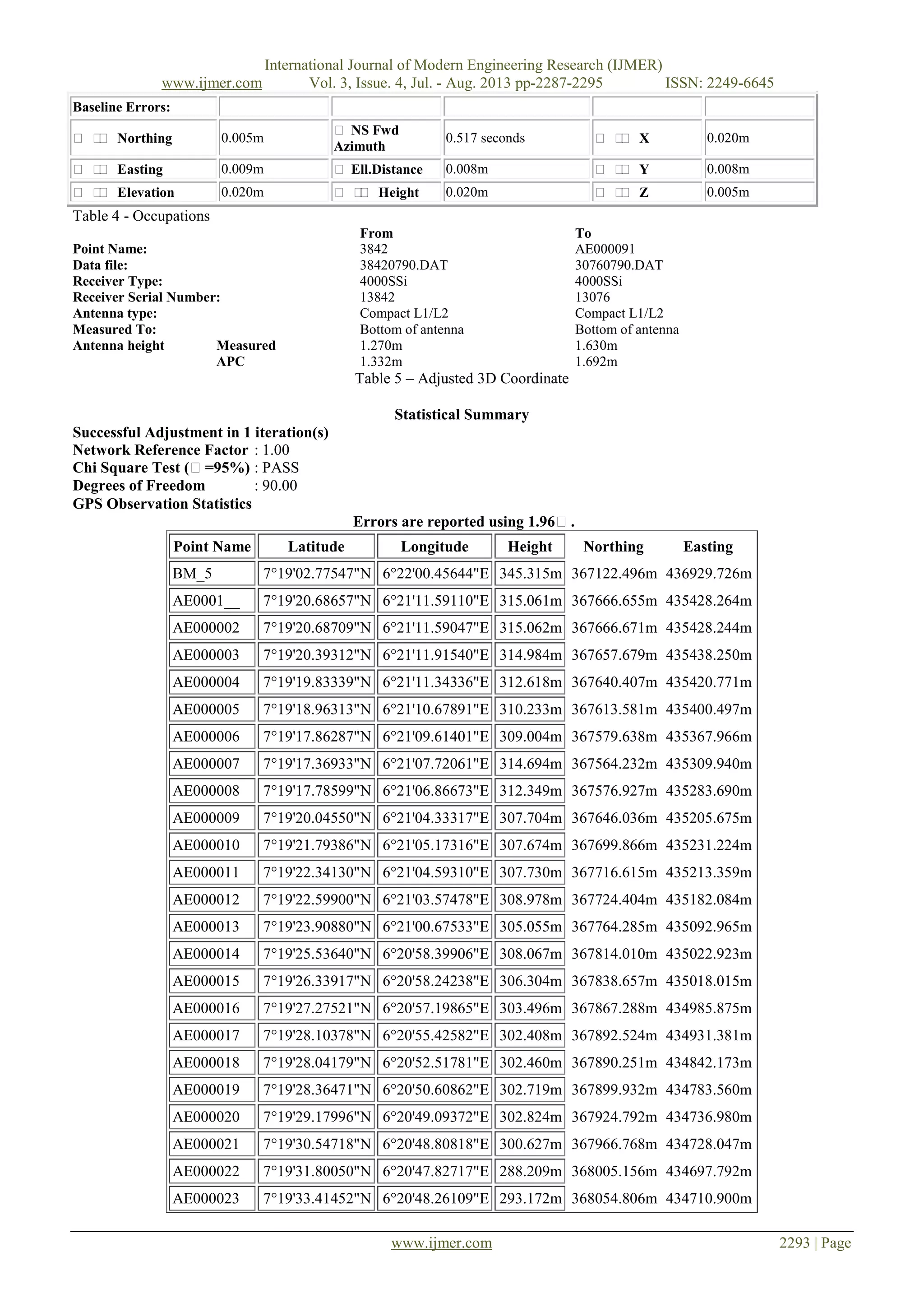
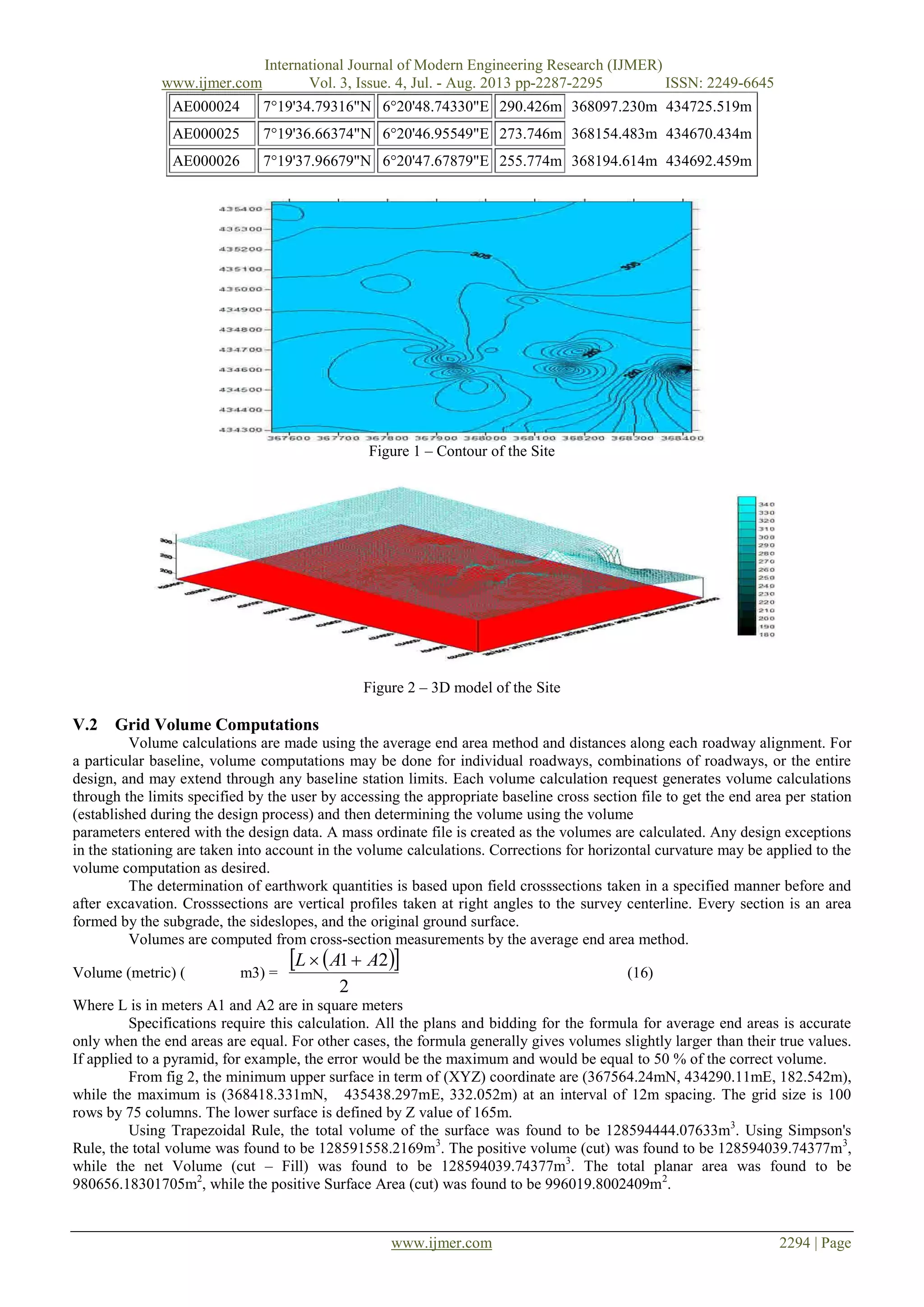
VI. DISCUSSION AND CONCLUSION
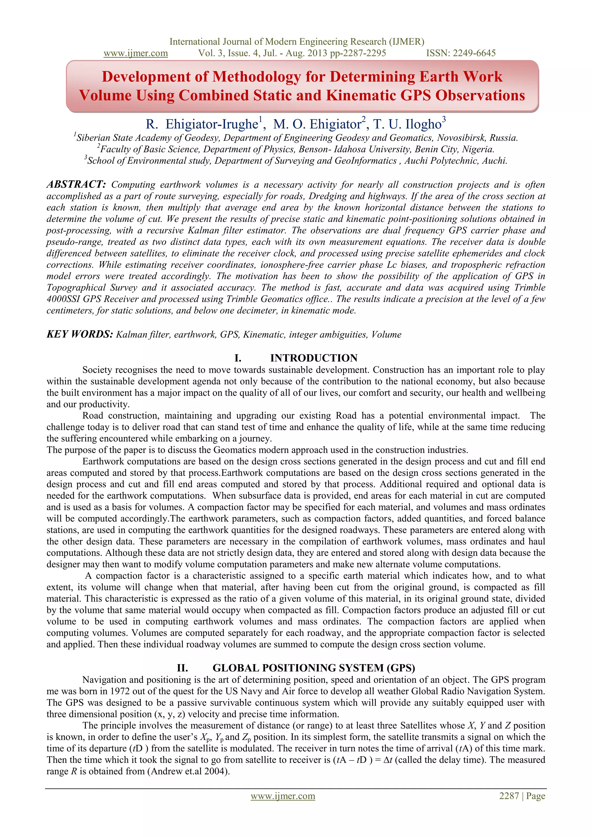
Our approach present baseline Static and kinematic GPS positioning by using standard Kalman filter process model.
Table 1 is the baseline processed results. Table 2 is the result of the adjusted 3D coordinate of the site investigated. Figure 1
is the contour showing the nature of the terrain. Figure 2 is the presented Digital Terrain Model (DTM). The DTM reveal the
area the will needed to be filled and cut. The quantity of material needed was also computed. The contour, 3D model, the
area and Volume was derived using SUFFER 8.0 software.
Performance assessment of the measurement system carried during the data acquisition involved the use of three
receivers, one control for static model and two rovers for Kinematic model both acquiring data at 5 seconds interval. From
the results obtained it can be concluded that GPS observation by combining static and kinematic models gives very high
accuracy for 3-D Survey.
REFERENCES
[1]. Andrew W. Sutter, Alan G. Evans (2004). Evaluation of Precise
[2]. Kinematic GPS Point Positioning. Proceedings of the Institute Of Navigation (ION) GNSS-2004 Meeting, Long Beach, California
[3]. Abdel-Salam, M. (2005) “Precise point positing using un-differenced code and carrier phase observation”. Ph.D dissertation,
Department of Geomatics Engineering, Schulich School of Engineering, University of Calgary, Alberta, Canada.
[4]. Raquet, F. J. (1998) “ Development of a method of kinematics GPS carrier phase ambiguity resolution using multiple reference
receivers” Ph.D Dissertation, Department of Geomatics Engineering, Schulich School of Engineering, University of Calgary,
Alberta Canada.
[5]. Schofield, W. (2009): Engineering Surveying; Theory and Examination Problems for Students, Fifth Edition Kingston University.
[6]. Schofield, W. (1993) “Engineering Surveying”. Butterworth –Heinemann Ltd, Oxford.
[7]. Kaplan, E.D. (1996) “Understanding GPS Principles and Application”.
[8]. Artech House publishers, Norwood.
[9]. Ehiorobo O.J (2008) “ Robustness analysis of a DGPS network for Earth Dam Deformation Monitoring”. PhD thesis, department
of Civil Engineering, University of Benin, Benin City Nigeria.
[10]. Ehiorobo O.J (2009) “ Accuracy of static differential GPS techniques: Implications for structural deformation monitoring”
Advanced materials Research, Trans Tech publications switzerland vol 62-64 pp 31-38.
[11]. Gao, Y and Chen, K. (2001) “ Improving Ambuiguity Convergence in Carrier Phase Based Precise Point Positioning‟‟,
Proceedings 10N, GPS 2001, Salt Lake City, Utah.