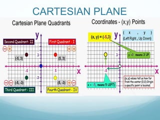
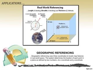
COORDINATE GEOMETRY
Past was base,
present is calculation &
future is application
Tanya Syngle
CARTESIAN PLANE
421
0011 0010 1010 1101 0001 0100 1011
HISTORY
One day , Renee Descartes, the French
mathematician noticed a fly crawling
around on the ceiling. He wanted to know
how to tell someone else where the fly was.
Finally he realized that he could describe
the position of the fly by its distance from
the walls of the room Then he tried
describing the positions of points, the same
way he described the position of the fly.
Descartes had invented the Cartesian plane!
In his honor, it is also called the Cartesian
plane
LOCATING A PLACE ON THE MAP
A 3-dimensional coordinate system uses angular measurements (X,Y) and
length (Z) to locate points on the earth’s surface. . The Prime Meridian
and Equator serve as base references.
APPLICATIONS…..
GEOGRAPHIC REFERENCING
. Geographic referencing uses three coordinates to locate map features
in real world space. The system determines the location of each point in
a plane as defined by two numbers—its x-coordinate and y-coordinate
APPLICATIONS…..
SATELLITE POSTIONING
A celestial coordinate system is a
system for specifying positions of
celestial objects: satellites, planets,
stars, galaxies, and so on. Coordinate
system can specify a position in 3-
dimensional space, or merely the
direction of the object on the celestial
sphere, if its distance is not known or
not important.
Co-ordinate geometry and Calculus
have been used for launch & geo-
positioning of the 60 satellites
launched by India from
Aryabhatta I in 1975 to the latest RISAT
I in 2012
APPLICATIONS…..
APPLICATIONS…..
Many modern cities like
Chicago have been built on
the basis of the Cartesian
plane .In Chicago, even the
names of streets follow the
Cartesian coordinate
system logic of East-West
and South-North .
APPLICATIONS…..
Archaeologists use a map and the
Cartesian coordinate system to:
• establish a grid system over an
archaeological site, labeling each
grid unit;
• determine the location of artifacts
within each grid unit;
• construct a scientific inquiry
concerning the location of artifacts
on the site.
APPLICATIONS…..
ARCHAEOLOGY
THANK YOU
WE KNOW THAT THE PAST WAS
INSPIRING,
WE KNOW THAT THE PRESENT IS GOING
GREAT,
&
I KNOW THAT THE FUTURE WILL BE
BREATHTAKING.

Coordinate Geometry

  • 1.
    COORDINATE GEOMETRY Past wasbase, present is calculation & future is application Tanya Syngle
  • 2.
  • 3.
    421 0011 0010 10101101 0001 0100 1011 HISTORY One day , Renee Descartes, the French mathematician noticed a fly crawling around on the ceiling. He wanted to know how to tell someone else where the fly was. Finally he realized that he could describe the position of the fly by its distance from the walls of the room Then he tried describing the positions of points, the same way he described the position of the fly. Descartes had invented the Cartesian plane! In his honor, it is also called the Cartesian plane
  • 4.
    LOCATING A PLACEON THE MAP A 3-dimensional coordinate system uses angular measurements (X,Y) and length (Z) to locate points on the earth’s surface. . The Prime Meridian and Equator serve as base references. APPLICATIONS…..
  • 5.
    GEOGRAPHIC REFERENCING . Geographicreferencing uses three coordinates to locate map features in real world space. The system determines the location of each point in a plane as defined by two numbers—its x-coordinate and y-coordinate APPLICATIONS…..
  • 6.
    SATELLITE POSTIONING A celestialcoordinate system is a system for specifying positions of celestial objects: satellites, planets, stars, galaxies, and so on. Coordinate system can specify a position in 3- dimensional space, or merely the direction of the object on the celestial sphere, if its distance is not known or not important. Co-ordinate geometry and Calculus have been used for launch & geo- positioning of the 60 satellites launched by India from Aryabhatta I in 1975 to the latest RISAT I in 2012 APPLICATIONS…..
  • 7.
  • 8.
    Many modern citieslike Chicago have been built on the basis of the Cartesian plane .In Chicago, even the names of streets follow the Cartesian coordinate system logic of East-West and South-North . APPLICATIONS…..
  • 9.
    Archaeologists use amap and the Cartesian coordinate system to: • establish a grid system over an archaeological site, labeling each grid unit; • determine the location of artifacts within each grid unit; • construct a scientific inquiry concerning the location of artifacts on the site. APPLICATIONS….. ARCHAEOLOGY
  • 10.
    THANK YOU WE KNOWTHAT THE PAST WAS INSPIRING, WE KNOW THAT THE PRESENT IS GOING GREAT, & I KNOW THAT THE FUTURE WILL BE BREATHTAKING.