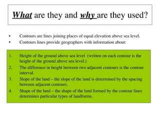
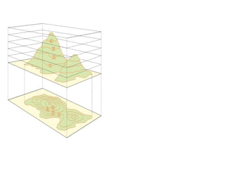
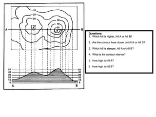
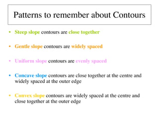
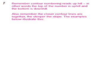
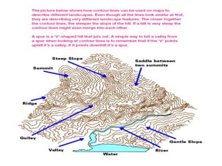
Contours are lines on a map connecting points of equal elevation above sea level. They provide information about the height of land, difference in height between contours, slope of land determined by contour spacing, and shape of landforms. Contour patterns indicate slope - steep slopes have close contours, gentle slopes have widely spaced contours, and concave and convex slopes have variable spacing that reveals the landform shape.
This presentation is for Grades 6 and 7. It is based on the Edexcel Curriculum. This is a geography ppt on Contour lines. Hope this helps you to teach your classes.
Compass surveying
Bearing
Whole circle bearing and reduced bearing
Conversion of bearings
Computation of angles
Declination and dip
Local attraction
Isogonic Lines
Agonic Lines
Detecting local attraction
For detecting local attraction it is necessary to take both fore bearing and back bearing for each line.
If the difference is exactly 180°, the two stations may be considered as not affected by local
attraction.
If difference is not 180°, better to go back to the previous station and check the fore bearing. If that
reading is same as earlier, it may be concluded that there is local attraction at one or both stations.
Techniques of Land Surveying
The structure of Presentation:
Introduction to Land Survey
History of Land Survey
Types of Land Survey
Measurements
Modern Technologies
Geographical Information System
Photogrammetry
LiDAR
Airborne LiDAR
3D laser scanners
What Exactly Is Contouring in Survey & Levelling?
It will be helpful for Architectural and Civil engineering students.
A presentation by Harshit Gupta (B.Arch 1st year).
Cartography is the science of map making related to geography, mathematics, geodesy, and human habitat, economy and society. Its a discipline developed during the early period of human civilization. With the development of science and technology, it has changed its paradigm twice. Its been digital, more integrated and very useful global media for communication.
Photograph taken from an aircraft commonly termed as aerial photograph have come to play and ever increasing role in the execution in cartographic mapping in various scales and in evaluation of natural resources of a region. Uses of aerial photographs in other fields are also manifold; in fact the scope seems limitless.
Surveying is an important part of Civil engineering. Various part like theodolite, plane table surveying, computation of area and volume are useful for all university examination and other competitive examination
Contour maps: preparation and understanding.VIVEK CHAUHAN
The theme behind preparation of contour maps, various projections of topographical features, the processor making them and methods used in their making.
Projections are an essentials part of every datasets. Basically, a projection is the mathematical operation needed to go from the planet actual shape to a flat map according to the Geographic Coordinate System.
This topic includes representation of topography by various non mathematical and mathematical methods.
Pictorial method (Hachure lines, Hill shading)
Mathematical method (Spot heights,Bench marks, Trigonometrical stations, Layer tint or altitude tints, Contour lines )
Combination of different methods
Combined gis 2(GEOGRAPHIC INFORMATION SYSTEM)musadoto
Distortions
• The earth is spherical, and a simple way of mapping it without distortion is to map it on a globe. However, mapping on globes is not possible.
• The transformation from the three-dimensional ellipsoid/sphere to the two-dimensional plane (flat) surface is not possible without some form of distortion.
• The distortions increase as the distance from the central point of the projection increases
• Areas smaller than 25 x 25 km:
No distortions
• Areas larger than 25 x 25 km:
Always distortions
• Map projections are used to control/minimize the distortions
Classification and properties of map projections
Properties of map projections
• Areas are everywhere correctly represented
• All distances are correctly represented
• All directions on the map are the same as on Earth
• All angles are correctly represented
• The shape of any area is correctly represented (e.g. a circle projected would remain a circle)
This Presentation is to made concepts about measuring the earth (to locate position of any person on the whole earth). For this purpose we re going step by step basis in this presentation.These steps are mentioned as contents. After that you may able to learn about measuring a person's position of earth. Thank you!
The French Revolution, which began in 1789, was a period of radical social and political upheaval in France. It marked the decline of absolute monarchies, the rise of secular and democratic republics, and the eventual rise of Napoleon Bonaparte. This revolutionary period is crucial in understanding the transition from feudalism to modernity in Europe.
For more information, visit-www.vavaclasses.com
How to Create Map Views in the Odoo 17 ERPCeline George
The map views are useful for providing a geographical representation of data. They allow users to visualize and analyze the data in a more intuitive manner.
Instructions for Submissions thorugh G- Classroom.pptxJheel Barad
This presentation provides a briefing on how to upload submissions and documents in Google Classroom. It was prepared as part of an orientation for new Sainik School in-service teacher trainees. As a training officer, my goal is to ensure that you are comfortable and proficient with this essential tool for managing assignments and fostering student engagement.
Welcome to TechSoup New Member Orientation and Q&A (May 2024).pdfTechSoup
In this webinar you will learn how your organization can access TechSoup's wide variety of product discount and donation programs. From hardware to software, we'll give you a tour of the tools available to help your nonprofit with productivity, collaboration, financial management, donor tracking, security, and more.
Ethnobotany and Ethnopharmacology:
Ethnobotany in herbal drug evaluation,
Impact of Ethnobotany in traditional medicine,
New development in herbals,
Bio-prospecting tools for drug discovery,
Role of Ethnopharmacology in drug evaluation,
Reverse Pharmacology.
2. What are they and why are they used?
• Contours are lines joining places of equal elevation above sea level.
• Contours lines provide geographers with information about:
1. Height of the ground above sea level (written on each contour is the
height of the ground above sea level.)
2. The difference in height between two adjacent contours is the contour
interval.
3. Slope of the land – the slope of the land is determined by the spacing
between adjacent contours.
4. Shape of the land – the shape of the land formed by the contour lines
determines particular types of landforms.
3.
4.
5.
6. Patterns to remember about Contours
• Steep slope contours are close together
• Gentle slope contours are widely spaced
• Uniform slope contours are evenly spaced
• Concave slope contours are close together at the centre and
widely spaced at the outer edge
• Convex slope contours are widely spaced at the centre and
close together at the outer edge