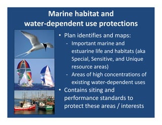
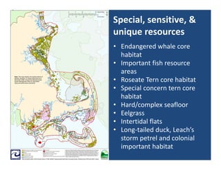
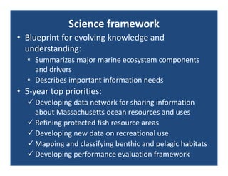
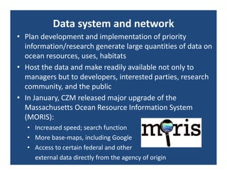
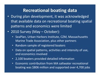
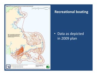
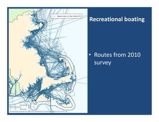
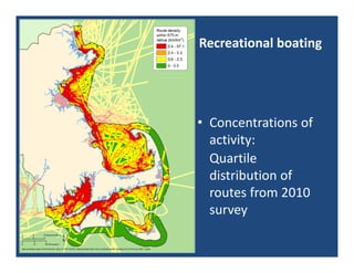
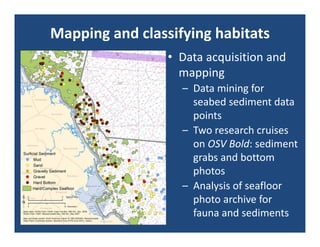
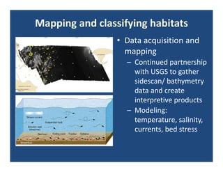
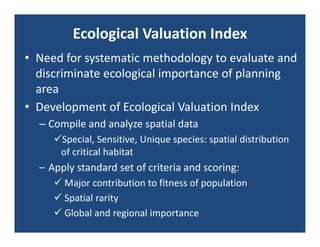
The document summarizes Massachusetts' progress in implementing its Ocean Management Plan. Key points include:
- The plan established siting standards and identified/mapped special marine habitats and areas of high existing ocean use to guide protection and development.
- Agencies are coordinating regulatory decisions and prioritizing science like improved mapping of habitats and recreational boating data.
- A case study showed how standards guided a cable project to avoid sensitive habitats through routing changes and construction methods.
- An Ecological Valuation Index was developed to systematically evaluate habitat importance, though it has limitations due to data availability.
The two countries in southern Africa have classic configuration of being located in transboundary basins. There are many similarities as regards their interdependence on riparians. The presentation summarises possible complementarity and consistency in transboundary water management. The findings are based on almost 30 months of work in the region.
Introduction of IWEco Project, April 2019 pdf (1)iweco-project
An introduction to the GEF-funded Integrating Water, Land and Ecosystems Management in Caribbean Small island Developing States (IWEco) Project, presented at the Project's Third Regional Project Steering Committee Meeting, Santo Domingo, Dominican Republic, 2 April 2019
Valuation of Marine Ecosystem Goods & Services in the Caribbean: A review and...Iwl Pcu
7th GEF Biennial International Waters Conference in Barbados Presentation on Valuation of Marine Ecosystem Goods & Services in the Caribbean by Patrick Debels and Laverne Walker
This presentation was given at the Catchment Management Network meeting on February 3rd 2017. The Catchment Management Network consists of the EPA, all of Ireland's Local Authorities, and other public bodies involved in looking after Ireland's catchments, sub-catchments and water bodies. For more information about this work see www.catchments.ie
Natural Capital Accounting in the Caribbean eftec January 2021iweco-project
This presentation, made at a UNEP GEF IWEco Project Partners' Webinar in January 2021, gave context on the conceptual underpinnings of natural capital accounting, and the general process by which the accounts are built. Links to international initiatives, such as the United Nations System of Environmental-Economic Accounting - Ecosystem Accounts (UN SEEA-EA), which provide a standardised understanding of how accounts should be produced (such as by National Statistics Offices), and the Sustainable Development Goals, were also explored. The practical application of natural capital accounting in the Caribbean was demonstrated through the UK Government funded “Caribbean Overseas Territories Regional Natural Capital Accounting Programme”. This programme is building capacity for natural capital accounting in the five Caribbean UK Overseas Territories, working with local government departments, and other local organisations, to collect data and produce environmental statistics within the natural capital accounting framework. These statistics will be able to sit alongside other national economic indicators, such as GDP, to help support better decision making in the region.
Hoe zit online auteursrecht in elkaar? In deze presentatie legt ICT-jurist uit waar auteursrecht ook alweer vandaan komt en wat het betekent in de online wereld van vandaag. Wat mag er wel, en wat mag er niet? Hoe ver gaat citaatrecht, kun je Youtube-films embedden en hoe zit het ook weer met portretrecht?
Gegeven op de informatiemiddag online auteursrecht van 20090612 bij Mindz.com
Oorsprong, Duiding en Toepassing van Open Source SoftwareFabrice Mous
Deze presentatie is opgedeeld in een drieluik waarbij wordt begonnen met het schetsen van de achtergrond en de oorsprong van open source software, waaronder het ontstaan van deze beweging, de softwarelicentie, de opkomst en de uiteindelijk commerciele acceptatie van open source software. Er volgt een verdieping op wat open source software is, welke kenmerken deze software heeft en waar open source software wordt gebruikt. Tot slot behandelt de presentatie een visie en aanpak om open source software 'werkend' te krijgen binnen de eigen organisatie.
The Alliance for a Healthy South Sound has been developing strategies to recover south sound. Elizabeth McManus (Ross Strategic) presented the draft strategies at the September NRC meeting.
Modeling the Effects of Sea Level Rise on Coastal Wetlands
Marc Carullo, GIS/Environmental Analyst, Massachusetts Office of Coastal Zone Management (CZM)
Aligning Watershed and Habitat Protection for Conservation Success in the Rac...rshimoda2014
Lindsay Gardner - Southeast Aquatics Resources Partnershp
Nothing is more important than water for human health and the health of our fish and wildlife resources. Clean water and abundant habitat are critical to functional aquatic ecosystems with healthy populations of fish and wildlife. Successful aquatic resource conservation at the watershed level requires a multipronged approach working with local communities to restore ecologically impacted or impaired streams and put land use/habitat protections in place. The collaborative efforts of the Southeast Watershed Forum (SEWF), Southeast Aquatic Resources Partnership (SARP), The Nature Conservancy (TNC), the Environmental Protection Agency (EPA), U.S. Fish & Wildlife Service (USFWS), Georgia Wildlife Resources Division (GWRD), and other key partners in the Raccoon Creek area of the Etowah River Watershed, Georgia, an EPA priority watershed, provide a positive example of this holistic approach to watershed management. Building on the conservation planning, land protection and restoration efforts by TNC on Raccoon Creek, this partnership is successfully working with Paulding County stakeholders to identify conservation priorities and align watershed and conservation planning with county land use planning to ensure long-term benefits for prime habitat and water quality. This work encourages conservation-oriented growth practices and habitat protections to benefit fish and wildlife, like the Cherokee darter, and supports the regional habitat objectives of the SARP-directed Southeast Aquatic Habitat Plan, addressing threats to aquatic resources and key habitat protections. An outstanding example of how on-the-ground restoration of aquatic resources at the local level, the project also addresses national conservation priorities and demonstrates how through community-supported land use quality growth planning it is possible to develop a strategy and stewardship ethic to maintain these resources for generations to come. Contributors: Christine Olsenius, Jane Fowler (SEWF); Scott Robinson, Lindsay Gardner (SARP); Kathleen Owens (TNC).
Recent presentation on assessing how U.S. Fish and Wildlife Service Hurricane Sandy Resilience projects will improve community and ecosystem resilience to sea level rise, storm events and other threats. Presentation highlights development of ecological and socio-economic metrics and provides project examples, marsh restoration, beach restoration, living shorelines and aquatic connectivity (dam removal) of metrics being used to evaluate project performance.
Shoreline Change Special Area Management Plan (Beach SAMP) Stakeholder Meeting. Held on July 14, 2015. The purpose of the meeting was to review progress to date on development of tools, and discuss the next phase of the Beach SAMP porject.
Sea Level Rise & the Conservation of Wetlands: Issues and Opportunities for C...riseagrant
Incorporating SLAMM Maps and Recommendation into Local Plans
Chelsea Siefert, RI Statewide Planning Program
Teresa Crean, URI Coastal Resources Center / RI Sea Grant
STORMTOOLS* -Simplified Flood Inundation Maps for RI with Sea Level Rise (SLR)riseagrant
Malcolm L. Spaulding1
Chris Damon2
1Professor Emeritus, Ocean Engineering
2Environmental Data Center
University of RI
December 9, 2014
*http://www.beachsamp.org/research/stormtools/
Narragansett, RI
Key Tools for Businesses
Overview of tools and resources that can help businesses address priority resilience issues. Fortified Commercial ™ – Chuck Miccolis, Insurance Institute for Business and Home Safety
Lessons from Sandy and Green Infrastructure Strategies riseagrant
Hoboken, New Jersey—Lessons from Sandy and Green Infrastructure Strategy. How to prepare for the next storm and be creative with flood control. Presented by Stephen Marks, City of Hoboken
Key Tools for Businesses: An overview of tools and resources that can help businesses address priority resilience issues. Resilience Green Infrastructure presented by James Houle, Stormwater Center, University of New Hampshire.
Gulf of Mexico Alliance Resilient Marina Checklistriseagrant
Key Tools for Businesses: An overview of tools and resources that can help businesses address priority resilience issues. Resilience Checklist presented by Lauren Land, Louisiana Sea Grant College Program
Builder.ai Founder Sachin Dev Duggal's Strategic Approach to Create an Innova...Ramesh Iyer
In today's fast-changing business world, Companies that adapt and embrace new ideas often need help to keep up with the competition. However, fostering a culture of innovation takes much work. It takes vision, leadership and willingness to take risks in the right proportion. Sachin Dev Duggal, co-founder of Builder.ai, has perfected the art of this balance, creating a company culture where creativity and growth are nurtured at each stage.
DevOps and Testing slides at DASA ConnectKari Kakkonen
My and Rik Marselis slides at 30.5.2024 DASA Connect conference. We discuss about what is testing, then what is agile testing and finally what is Testing in DevOps. Finally we had lovely workshop with the participants trying to find out different ways to think about quality and testing in different parts of the DevOps infinity loop.
State of ICS and IoT Cyber Threat Landscape Report 2024 previewPrayukth K V
The IoT and OT threat landscape report has been prepared by the Threat Research Team at Sectrio using data from Sectrio, cyber threat intelligence farming facilities spread across over 85 cities around the world. In addition, Sectrio also runs AI-based advanced threat and payload engagement facilities that serve as sinks to attract and engage sophisticated threat actors, and newer malware including new variants and latent threats that are at an earlier stage of development.
The latest edition of the OT/ICS and IoT security Threat Landscape Report 2024 also covers:
State of global ICS asset and network exposure
Sectoral targets and attacks as well as the cost of ransom
Global APT activity, AI usage, actor and tactic profiles, and implications
Rise in volumes of AI-powered cyberattacks
Major cyber events in 2024
Malware and malicious payload trends
Cyberattack types and targets
Vulnerability exploit attempts on CVEs
Attacks on counties – USA
Expansion of bot farms – how, where, and why
In-depth analysis of the cyber threat landscape across North America, South America, Europe, APAC, and the Middle East
Why are attacks on smart factories rising?
Cyber risk predictions
Axis of attacks – Europe
Systemic attacks in the Middle East
Download the full report from here:
https://sectrio.com/resources/ot-threat-landscape-reports/sectrio-releases-ot-ics-and-iot-security-threat-landscape-report-2024/
LF Energy Webinar: Electrical Grid Modelling and Simulation Through PowSyBl -...DanBrown980551
Do you want to learn how to model and simulate an electrical network from scratch in under an hour?
Then welcome to this PowSyBl workshop, hosted by Rte, the French Transmission System Operator (TSO)!
During the webinar, you will discover the PowSyBl ecosystem as well as handle and study an electrical network through an interactive Python notebook.
PowSyBl is an open source project hosted by LF Energy, which offers a comprehensive set of features for electrical grid modelling and simulation. Among other advanced features, PowSyBl provides:
- A fully editable and extendable library for grid component modelling;
- Visualization tools to display your network;
- Grid simulation tools, such as power flows, security analyses (with or without remedial actions) and sensitivity analyses;
The framework is mostly written in Java, with a Python binding so that Python developers can access PowSyBl functionalities as well.
What you will learn during the webinar:
- For beginners: discover PowSyBl's functionalities through a quick general presentation and the notebook, without needing any expert coding skills;
- For advanced developers: master the skills to efficiently apply PowSyBl functionalities to your real-world scenarios.
Dev Dives: Train smarter, not harder – active learning and UiPath LLMs for do...UiPathCommunity
💥 Speed, accuracy, and scaling – discover the superpowers of GenAI in action with UiPath Document Understanding and Communications Mining™:
See how to accelerate model training and optimize model performance with active learning
Learn about the latest enhancements to out-of-the-box document processing – with little to no training required
Get an exclusive demo of the new family of UiPath LLMs – GenAI models specialized for processing different types of documents and messages
This is a hands-on session specifically designed for automation developers and AI enthusiasts seeking to enhance their knowledge in leveraging the latest intelligent document processing capabilities offered by UiPath.
Speakers:
👨🏫 Andras Palfi, Senior Product Manager, UiPath
👩🏫 Lenka Dulovicova, Product Program Manager, UiPath
Encryption in Microsoft 365 - ExpertsLive Netherlands 2024Albert Hoitingh
In this session I delve into the encryption technology used in Microsoft 365 and Microsoft Purview. Including the concepts of Customer Key and Double Key Encryption.
GDG Cloud Southlake #33: Boule & Rebala: Effective AppSec in SDLC using Deplo...James Anderson
Effective Application Security in Software Delivery lifecycle using Deployment Firewall and DBOM
The modern software delivery process (or the CI/CD process) includes many tools, distributed teams, open-source code, and cloud platforms. Constant focus on speed to release software to market, along with the traditional slow and manual security checks has caused gaps in continuous security as an important piece in the software supply chain. Today organizations feel more susceptible to external and internal cyber threats due to the vast attack surface in their applications supply chain and the lack of end-to-end governance and risk management.
The software team must secure its software delivery process to avoid vulnerability and security breaches. This needs to be achieved with existing tool chains and without extensive rework of the delivery processes. This talk will present strategies and techniques for providing visibility into the true risk of the existing vulnerabilities, preventing the introduction of security issues in the software, resolving vulnerabilities in production environments quickly, and capturing the deployment bill of materials (DBOM).
Speakers:
Bob Boule
Robert Boule is a technology enthusiast with PASSION for technology and making things work along with a knack for helping others understand how things work. He comes with around 20 years of solution engineering experience in application security, software continuous delivery, and SaaS platforms. He is known for his dynamic presentations in CI/CD and application security integrated in software delivery lifecycle.
Gopinath Rebala
Gopinath Rebala is the CTO of OpsMx, where he has overall responsibility for the machine learning and data processing architectures for Secure Software Delivery. Gopi also has a strong connection with our customers, leading design and architecture for strategic implementations. Gopi is a frequent speaker and well-known leader in continuous delivery and integrating security into software delivery.
Generating a custom Ruby SDK for your web service or Rails API using Smithyg2nightmarescribd
Have you ever wanted a Ruby client API to communicate with your web service? Smithy is a protocol-agnostic language for defining services and SDKs. Smithy Ruby is an implementation of Smithy that generates a Ruby SDK using a Smithy model. In this talk, we will explore Smithy and Smithy Ruby to learn how to generate custom feature-rich SDKs that can communicate with any web service, such as a Rails JSON API.
Key Trends Shaping the Future of Infrastructure.pdfCheryl Hung
Keynote at DIGIT West Expo, Glasgow on 29 May 2024.
Cheryl Hung, ochery.com
Sr Director, Infrastructure Ecosystem, Arm.
The key trends across hardware, cloud and open-source; exploring how these areas are likely to mature and develop over the short and long-term, and then considering how organisations can position themselves to adapt and thrive.
2. Outline
• Before / after MA Ocean
Management Plan:
– Siting and management
standards
– Protecting critical marine
resources and uses
– Collaborative government
• Progress on advancing
identified priorities
• EVI: the one that got away
3. W
“ e have also been particularly mindful of current
uses and natural resource qualities of the state’s oceans,
and of our state’s rich cultural, social, and economic
heritage that has been tied so closely to the ocean and
our varied interactions to it. We took as our point of
departure the current state of resources and uses,
growing tensions between existing and proposed uses
and resource needs, and the current set of laws and
regulations affecting them, in order to consider what
legal authorities and action might be needed to assure
that the Bay State's public trust ocean resources are
adequately protected while also fostering sustainable
uses of them. ”
‐ Massachusetts Ocean Management Task Force, 2004
5. Ocean Act of 2008
• Ocean Management Task Force 2003‐2004: set of
findings and recommendations
• Act directs Secretary of EEA to develop integrated
ocean management plan by December 31, 2009
• 15 directives, including:
– Develop siting priorities, locations, and standards for
allowed uses, facilities, activities
– Identify and protect special, sensitive, and unique
estuarine and marine life and habitats
– Foster sustainable uses
– Support infrastructure necessary for economy and
quality of life
• All state approvals must be consistent with Plan
7. Ocean Plan
• Draft Plan issued June
2009
• Final Plan promulgated
December 2009
• Volume I
– Management
– Administration
• Volume II
– Baseline Assessment
– Science Framework
8. Marine habitat and
water‐dependent use protections
• Plan identifies and maps:
‐ Important marine and
estuarine life and habitats (aka
Special, Sensitive, and Unique
resource areas)
‐ Areas of high concentrations of
existing water‐dependent uses
• Contains siting and
performance standards to
protect these areas / interests
9. Administration and priorities
• Interagency management coordination / integration
– Planning and coordination for regulatory decision‐making
and science and data priorities
• Protocols for Plan updates and amendments
– Updates to adopt new geospatial data/information on
uses or resources; correct errata, technicalities
– Amendments for changes to specified management area
boundaries, protected uses / resources, standards
• Science Framework
– Blueprint for evolving knowledge and understanding
– Describes important information needs and identifies top
5‐year priorities
10. Special, sensitive, &
unique resources
• Endangered whale core
habitat
• Important fish resource
areas
• Roseate Tern core habitat
• Special concern tern core
habitat
• Hard/complex seafloor
• Eelgrass
• Intertidal flats
• Long‐tailed duck, Leach’s
storm petrel and colonial
important habitat
11. Marine habitat protection
• Specified activities are presumptively excluded
from SSU areas; may be overcome by a clear
demonstration that:
– No less environmentally damaging practicable
alternative exists, or
– All practicable steps taken to avoid damage and
project will cause no significant alteration to SSU
resource and values, and
– Public benefits associated with the proposed project
clearly outweigh the public detriment to the SSU
• Siting review completed by agencies during MEPA
review: coordinated and collaborative
12. Project case study
• Comcast Fiber Optic Cable
Project:
– Purpose is to provide
redundant upland and
submarine cable to Martha’s
Vineyard to ensure critical
telecommunication
100% of time
– Falmouth to Tisbury on
Martha’s Vineyard
– SSU resources:
hard/complex bottom,
eelgrass
13. Project case study
• Pre‐application
coordination :
– Proponent meetings with
agencies
– Ocean plan standards: need
to avoid SSU areas
– Need to conduct survey and
site characterization
• Reconnaissance and route
surveys
– Sonar, video, grabs
– 600’ corridor, transects
15. Science framework
• Blueprint for evolving knowledge and
understanding:
• Summarizes major marine ecosystem components
and drivers
• Describes important information needs
• 5‐year top priorities:
Developing data network for sharing information
about Massachusetts ocean resources and uses
Refining protected fish resource areas
Developing new data on recreational use
Mapping and classifying benthic and pelagic habitats
Developing performance evaluation framework
16. Data system and network
• Plan development and implementation of priority
information/research generate large quantities of data on
ocean resources, uses, habitats
• Host the data and make readily available not only to
managers but to developers, interested parties, research
community, and the public
• In January, CZM released major upgrade of the
Massachusetts Ocean Resource Information System
(MORIS):
• Increased speed; search function
• More base‐maps, including Google
• Access to certain federal and other
external data directly from the agency of origin
17. Recreational boating data
• During plan development, it was acknowledged
that available data on recreational boating spatial
patterns and economics were limited
• 2010 Survey (May – October):
• SeaPlan, Urban Harbors Institute, CZM, Massachusetts
Marine Trade Association, plus other partners
• Random sample of registered boaters
• Data on spatial patterns, activities and intensity of use,
and economics involved
• 2,100 boaters provided detailed information
• Economic contribution from MA saltwater recreational
boating was $806 million and supported over 4,700 jobs
21. Mapping and classifying habitats
• Data acquisition and
mapping
– Data mining for
seabed sediment data
points
– Two research cruises
on OSV Bold: sediment
grabs and bottom
photos
– Analysis of seafloor
photo archive for
fauna and sediments
22. Mapping and classifying habitats
• Data acquisition and
mapping
– Continued partnership
with USGS to gather
sidescan/ bathymetry
data and create
interpretive products
– Modeling:
temperature, salinity,
currents, bed stress
24. Ecological Valuation Index
• Need for systematic methodology to evaluate and
discriminate ecological importance of planning
area
• Development of Ecological Valuation Index
– Compile and analyze spatial data
Special, Sensitive, Unique species: spatial distribution
of critical habitat
– Apply standard set of criteria and scoring:
Major contribution to fitness of population
Spatial rarity
Global and regional importance
25. Ecological Valuation Index
Ecological Valuation Index: Ecological Valuation Index: Ecological Valuation Index:
Quartile distribution Quartile distribution Decile distribution
all scores for species all scores for species all scores for species
occurring in grid cell occurring in grid cell occurring in grid cell
by group by group
26. Ecological Valuation Index
• Benefits of EVI
– Differentiates areas in terms of their ecological value,
using data on marine organisms
– Help identify areas especially suitable for protection
– Important step toward managing based on
ecosystem perspective
• Limitations of EVI
– Data availability and spatial resolution
– Difficulties in applications for abiotic endpoints as
well as space / time
– Coarse tool: evolving understanding of ocean
ecosystem interactions