SlideShare a Scribd company logo
1 of 17
Download to read offline
Imagery Interpretation for
Coastal and Marine Spatial Planning
Prepared for:
2011 NOAA GeoTools
Keith B. VanGraafeiland
Stephen T. Viada
M. John Thompson
Brian Balcom
George McLeod
Acknowledgments
Anadarko Petroleum Corporation (APC)
• John Peffer
• Mario Rassul
• Karina Pena
Purpose
• Remote Sensing Data
– Satellite imagery
– Side-scan sonar
• GIS Habitat Mapping
– Imagery classification
– Imagery interpretation
• Environmental Sensitivity Analysis Methods
– Identify features and areas of concern for
avoidance and to minimize environmental impacts
• Produce
– Environmental Sensitivity Index (ESI) maps
– Thematic maps
– Statistical summaries (areal and linear
dimensions) of habitat type
• Support
– Environmental Impact Assessments (EIAs)
– Environmental Impact Studies (EISs)
– Environmental Baseline Surveys (EBSs)
– Monitoring plans
– Spill contingency plans
Purpose (Cont.)
Case Study
Northern Mozambique, Africa
• A 2D and 3D geophysical
survey program proposed
within shallow waters of the
Quirimbas Archipelago,
Mozambique
Study purpose
• Locate seafloor features
warranting environmental
protection from seismic
operations
• Develop a mitigation plan to
minimize potential
environmental impacts
Study Objectives
1. Characterize and map marine habitats
2. Identify physical areas of concern
3. Develop a mitigation plan
4. Implement a field survey to delineate
areas of environmental concern
Deliverables
• EIA, with an approved environmental
impact mitigation plan
• Environmental Management Plan (EMP)
• Mangrove-dominated communities
• Submerged aquatic vegetation
• Bare sand and mud substrates
• Shallow and emergent hard substrates
• Shallow and emergent coral
communities
• Deepwater coral communities
Objective 1:
Characterization and Mapping of
Shallow Water Marine Habitats
• A set of high resolution remote sensing
(satellite imagery) tiles of the coastal and
nearshore waters of the project area were
used to create a georeferenced mosaic
• Habitat categories were identified and coded
as colored polygons, creating a
georeferenced habitat map
Objective 1 (Cont.)
• ESI methods were used to
determine the relative
sensitivity of each identified
habitat category
• Sources of environmental
impact
– Seismic sound pressure waves
– Physical contact with receiver
cables and autonomous
receivers
Objective 2:
Habitat Sensitivity Analysis
Potential Levels of Impact Severity
Impact Severity Consequence
Negligible
Negligible or little harm to sensitive resources, with reversible effects
Little or no environmental exposure
Minor
Low, minor environmental impact
Exposure limited to immediate site
Moderate
Medium, moderate environmental impact
Incident potentially contaminating local resources
Significant
Major environmental impact (see text below)
Environmental incident resulting in contamination of local resources
Catastrophic
Catastrophic disaster, major environmental impact
Major environmental incident causing significant regional damage to the environment
Scale of Environmental Sensitivity
1
Negligible
2
Minor
3
Moderate
4
Significant
5
Catastrophic
Severity of Impact
––––––––►
Objective 3:
Develop a Mitigation Plan for the Protection
of the Identified Areas of Concern
• From the ESI results, an impact
mitigation strategy was designed
to avoid or minimize potential
impacts to sensitive marine
resources and habitats
• Mitigation measures consisted of
acoustic exclusion zones
(“buffer zones”), considering
proposed activity scenarios
Objective 4:
Field Survey
• A field survey was designed and implemented
to accurately and efficiently identify and
delineate areas that met sensitive habitat
criteria
Field Survey Methods
• Preliminary mapping survey of selected
segments with digital side-scan sonar
• Visual assessment (groundtruthing) of selected
seafloor features by divers
Survey Data Analysis
The processed sonar
data swath was
superimposed on the
satellite mosaic for
interpretation
Each proposed
seismic survey
trackline was
superimposed on
the corresponding
satellite mosaic
Survey Data Analysis (Cont.)
Results obtained
from
groundtruthing
selected targets
provided
supportive
information for
seafloor
interpretation
Selected
groundtruth targets
were plotted, and
areas meeting
selection criteria
were provided a
buffer of 75 m
The final product
comprised a
color-coded
overlay of the
surveyed trackline
segment
Survey Results
• 250 km were surveyed
• 90 km were in water depths <2 m
• 42 km were designated as sensitive habitat
• 118 km did not contain sensitive habitat or
were too deep to survey
Conclusions
• Sensitive shallow water habitats
were mapped within the project
area
• Acoustic exclusion areas
(buffers) for selected resources
were implemented
• The methods provide a practical
and efficient means to
characterize and map seafloor
habitats within large geographic
areas and may be applied to
other activity scenarios and
geographic areas

More Related Content

What's hot

Gi4DM2010 GIS and geomatics for disaster relief
Gi4DM2010 GIS and geomatics for disaster reliefGi4DM2010 GIS and geomatics for disaster relief
Gi4DM2010 GIS and geomatics for disaster reliefMassimo Lanfranco
 
Item 12: Preparation of global maps of soil salinity, soil erosion, and GLOSI...
Item 12: Preparation of global maps of soil salinity, soil erosion, and GLOSI...Item 12: Preparation of global maps of soil salinity, soil erosion, and GLOSI...
Item 12: Preparation of global maps of soil salinity, soil erosion, and GLOSI...FAO
 
Final PhD thesis Defense Presentation Tohoku University Japan
Final PhD thesis Defense Presentation Tohoku University JapanFinal PhD thesis Defense Presentation Tohoku University Japan
Final PhD thesis Defense Presentation Tohoku University JapanRamanBiswas
 
EDA_report_Agbenowu et al
EDA_report_Agbenowu et alEDA_report_Agbenowu et al
EDA_report_Agbenowu et alMuhammad Waseem
 
Detecting and quantifying desertification in the upper east region of ghana u...
Detecting and quantifying desertification in the upper east region of ghana u...Detecting and quantifying desertification in the upper east region of ghana u...
Detecting and quantifying desertification in the upper east region of ghana u...Alexander Decker
 
160180106099 disaster management[1]
160180106099 disaster management[1]160180106099 disaster management[1]
160180106099 disaster management[1]Ronik Solanki
 
remote sensing in agriculture
remote sensing in agricultureremote sensing in agriculture
remote sensing in agricultureveerendra manduri
 
Disaster management using Remote sensing and GIS
Disaster management using Remote sensing and GISDisaster management using Remote sensing and GIS
Disaster management using Remote sensing and GISHarsh Singh
 
NOAA's GLRI Projects in 2010
NOAA's GLRI Projects in 2010NOAA's GLRI Projects in 2010
NOAA's GLRI Projects in 2010Lynne Chaimowitz
 
Role of GIS and remote sensing in Disaster Management
  Role of GIS and remote sensing in Disaster Management  Role of GIS and remote sensing in Disaster Management
Role of GIS and remote sensing in Disaster ManagementLeema Margret A
 
How humans are affected by physical features -for grade 6
How humans are affected by physical features -for grade 6How humans are affected by physical features -for grade 6
How humans are affected by physical features -for grade 6nnakvi
 
2021 icse reducedsylabiix-geography
2021 icse reducedsylabiix-geography2021 icse reducedsylabiix-geography
2021 icse reducedsylabiix-geographyVahabshaik Shai
 
Section 01
Section 01Section 01
Section 01CCEW
 
Soil Atlas of Asia: Japan
Soil Atlas of Asia: JapanSoil Atlas of Asia: Japan
Soil Atlas of Asia: JapanExternalEvents
 
Adaptive response strategy of farmers to changing rainfall averages in parts ...
Adaptive response strategy of farmers to changing rainfall averages in parts ...Adaptive response strategy of farmers to changing rainfall averages in parts ...
Adaptive response strategy of farmers to changing rainfall averages in parts ...Alexander Decker
 
Panel area-details
Panel area-detailsPanel area-details
Panel area-detailsabhisheksdpm
 
Roadless area initiative
Roadless area initiativeRoadless area initiative
Roadless area initiativeZoltan Kun
 

What's hot (20)

Gi4DM2010 GIS and geomatics for disaster relief
Gi4DM2010 GIS and geomatics for disaster reliefGi4DM2010 GIS and geomatics for disaster relief
Gi4DM2010 GIS and geomatics for disaster relief
 
Chapter 1
Chapter 1 Chapter 1
Chapter 1
 
Item 12: Preparation of global maps of soil salinity, soil erosion, and GLOSI...
Item 12: Preparation of global maps of soil salinity, soil erosion, and GLOSI...Item 12: Preparation of global maps of soil salinity, soil erosion, and GLOSI...
Item 12: Preparation of global maps of soil salinity, soil erosion, and GLOSI...
 
Final PhD thesis Defense Presentation Tohoku University Japan
Final PhD thesis Defense Presentation Tohoku University JapanFinal PhD thesis Defense Presentation Tohoku University Japan
Final PhD thesis Defense Presentation Tohoku University Japan
 
EDA_report_Agbenowu et al
EDA_report_Agbenowu et alEDA_report_Agbenowu et al
EDA_report_Agbenowu et al
 
Detecting and quantifying desertification in the upper east region of ghana u...
Detecting and quantifying desertification in the upper east region of ghana u...Detecting and quantifying desertification in the upper east region of ghana u...
Detecting and quantifying desertification in the upper east region of ghana u...
 
160180106099 disaster management[1]
160180106099 disaster management[1]160180106099 disaster management[1]
160180106099 disaster management[1]
 
remote sensing in agriculture
remote sensing in agricultureremote sensing in agriculture
remote sensing in agriculture
 
Disaster management using Remote sensing and GIS
Disaster management using Remote sensing and GISDisaster management using Remote sensing and GIS
Disaster management using Remote sensing and GIS
 
NOAA's GLRI Projects in 2010
NOAA's GLRI Projects in 2010NOAA's GLRI Projects in 2010
NOAA's GLRI Projects in 2010
 
Role of GIS and remote sensing in Disaster Management
  Role of GIS and remote sensing in Disaster Management  Role of GIS and remote sensing in Disaster Management
Role of GIS and remote sensing in Disaster Management
 
How humans are affected by physical features -for grade 6
How humans are affected by physical features -for grade 6How humans are affected by physical features -for grade 6
How humans are affected by physical features -for grade 6
 
Credit seminar
Credit seminarCredit seminar
Credit seminar
 
2021 icse reducedsylabiix-geography
2021 icse reducedsylabiix-geography2021 icse reducedsylabiix-geography
2021 icse reducedsylabiix-geography
 
Evaluating soil erosion using gis
Evaluating soil erosion using gisEvaluating soil erosion using gis
Evaluating soil erosion using gis
 
Section 01
Section 01Section 01
Section 01
 
Soil Atlas of Asia: Japan
Soil Atlas of Asia: JapanSoil Atlas of Asia: Japan
Soil Atlas of Asia: Japan
 
Adaptive response strategy of farmers to changing rainfall averages in parts ...
Adaptive response strategy of farmers to changing rainfall averages in parts ...Adaptive response strategy of farmers to changing rainfall averages in parts ...
Adaptive response strategy of farmers to changing rainfall averages in parts ...
 
Panel area-details
Panel area-detailsPanel area-details
Panel area-details
 
Roadless area initiative
Roadless area initiativeRoadless area initiative
Roadless area initiative
 

Similar to Imagery Interpretation for Coastal and Marine Spatial Planning

Use of remote sensing for land cover monitoring servir science applications
Use of remote sensing for land cover monitoring servir science applicationsUse of remote sensing for land cover monitoring servir science applications
Use of remote sensing for land cover monitoring servir science applicationsKabir Uddin
 
Lecture 8: Spatial Planning for Disaster Risk Reduction
Lecture 8: Spatial Planning for Disaster Risk ReductionLecture 8: Spatial Planning for Disaster Risk Reduction
Lecture 8: Spatial Planning for Disaster Risk ReductionESD UNU-IAS
 
Unit 6 environmental_impact_assessment
Unit 6 environmental_impact_assessmentUnit 6 environmental_impact_assessment
Unit 6 environmental_impact_assessmentHarish kumar Lekkala
 
Remote Sensing Presentation
Remote Sensing PresentationRemote Sensing Presentation
Remote Sensing PresentationKamran Ahmed
 
Ecological and socio economic vulnerability to Climate change
Ecological and socio economic vulnerability to Climate changeEcological and socio economic vulnerability to Climate change
Ecological and socio economic vulnerability to Climate changemehebubsahana
 
June2016_comprehensive
June2016_comprehensiveJune2016_comprehensive
June2016_comprehensiveNicole Carlozo
 
Planning for Whitebait : Applying vulnerability assessment to īnanga spawning...
Planning for Whitebait: Applying vulnerability assessment to īnanga spawning...Planning for Whitebait: Applying vulnerability assessment to īnanga spawning...
Planning for Whitebait : Applying vulnerability assessment to īnanga spawning...Shane Orchard
 
EIA of offshore drilling and dredging
EIA of  offshore drilling and dredgingEIA of  offshore drilling and dredging
EIA of offshore drilling and dredgingbivin ebenezer
 
Blue carbon in the Pacific: Background and opportunities
Blue carbon in the Pacific: Background and opportunitiesBlue carbon in the Pacific: Background and opportunities
Blue carbon in the Pacific: Background and opportunitiesCIFOR-ICRAF
 
Zipporah Musyimi CLIFF Workshop
Zipporah Musyimi CLIFF WorkshopZipporah Musyimi CLIFF Workshop
Zipporah Musyimi CLIFF WorkshopMerylRichards
 
Ian Davies - Recent experience of Cumulative Impact Assessment in renewables ...
Ian Davies - Recent experience of Cumulative Impact Assessment in renewables ...Ian Davies - Recent experience of Cumulative Impact Assessment in renewables ...
Ian Davies - Recent experience of Cumulative Impact Assessment in renewables ...andronikos1990
 
Application of remote sensing in coastal zone management
Application of remote sensing in coastal zone managementApplication of remote sensing in coastal zone management
Application of remote sensing in coastal zone managementMayur Tade
 
Making land-use climate resilient: A participatory watershed management appr...
Making land-use climate resilient: A participatory watershed management appr...Making land-use climate resilient: A participatory watershed management appr...
Making land-use climate resilient: A participatory watershed management appr...Global Landscapes Forum (GLF)
 
Environmental impact assessment
Environmental impact assessmentEnvironmental impact assessment
Environmental impact assessmentKashmeera N.A.
 
1.m. clark environmental obligations
1.m. clark environmental obligations1.m. clark environmental obligations
1.m. clark environmental obligationsBill Bly
 
Asclme monitoring and indicators scott for iw learn v3
Asclme monitoring and indicators scott for iw learn v3Asclme monitoring and indicators scott for iw learn v3
Asclme monitoring and indicators scott for iw learn v3Iwl Pcu
 
Long Term Monitoring and Ecosystem Indicators Experience and perspectives fro...
Long Term Monitoring and Ecosystem Indicators Experience and perspectives fro...Long Term Monitoring and Ecosystem Indicators Experience and perspectives fro...
Long Term Monitoring and Ecosystem Indicators Experience and perspectives fro...Iwl Pcu
 

Similar to Imagery Interpretation for Coastal and Marine Spatial Planning (20)

Use of remote sensing for land cover monitoring servir science applications
Use of remote sensing for land cover monitoring servir science applicationsUse of remote sensing for land cover monitoring servir science applications
Use of remote sensing for land cover monitoring servir science applications
 
Lecture 8: Spatial Planning for Disaster Risk Reduction
Lecture 8: Spatial Planning for Disaster Risk ReductionLecture 8: Spatial Planning for Disaster Risk Reduction
Lecture 8: Spatial Planning for Disaster Risk Reduction
 
Unit 6 environmental_impact_assessment
Unit 6 environmental_impact_assessmentUnit 6 environmental_impact_assessment
Unit 6 environmental_impact_assessment
 
Targeting for diverse ecosystem zimmerman
Targeting for diverse ecosystem   zimmermanTargeting for diverse ecosystem   zimmerman
Targeting for diverse ecosystem zimmerman
 
Remote Sensing Presentation
Remote Sensing PresentationRemote Sensing Presentation
Remote Sensing Presentation
 
Ecological and socio economic vulnerability to Climate change
Ecological and socio economic vulnerability to Climate changeEcological and socio economic vulnerability to Climate change
Ecological and socio economic vulnerability to Climate change
 
June2016_comprehensive
June2016_comprehensiveJune2016_comprehensive
June2016_comprehensive
 
Planning for Whitebait : Applying vulnerability assessment to īnanga spawning...
Planning for Whitebait: Applying vulnerability assessment to īnanga spawning...Planning for Whitebait: Applying vulnerability assessment to īnanga spawning...
Planning for Whitebait : Applying vulnerability assessment to īnanga spawning...
 
EIA of offshore drilling and dredging
EIA of  offshore drilling and dredgingEIA of  offshore drilling and dredging
EIA of offshore drilling and dredging
 
Blue carbon in the Pacific: Background and opportunities
Blue carbon in the Pacific: Background and opportunitiesBlue carbon in the Pacific: Background and opportunities
Blue carbon in the Pacific: Background and opportunities
 
ROLE OF EIA IN BIODIVERSITY.pdf
ROLE OF EIA IN BIODIVERSITY.pdfROLE OF EIA IN BIODIVERSITY.pdf
ROLE OF EIA IN BIODIVERSITY.pdf
 
Pastoral Land Management Options in the Sahel: The Consequent Climate Forcings
Pastoral Land Management Options in the Sahel: The Consequent Climate ForcingsPastoral Land Management Options in the Sahel: The Consequent Climate Forcings
Pastoral Land Management Options in the Sahel: The Consequent Climate Forcings
 
Zipporah Musyimi CLIFF Workshop
Zipporah Musyimi CLIFF WorkshopZipporah Musyimi CLIFF Workshop
Zipporah Musyimi CLIFF Workshop
 
Ian Davies - Recent experience of Cumulative Impact Assessment in renewables ...
Ian Davies - Recent experience of Cumulative Impact Assessment in renewables ...Ian Davies - Recent experience of Cumulative Impact Assessment in renewables ...
Ian Davies - Recent experience of Cumulative Impact Assessment in renewables ...
 
Application of remote sensing in coastal zone management
Application of remote sensing in coastal zone managementApplication of remote sensing in coastal zone management
Application of remote sensing in coastal zone management
 
Making land-use climate resilient: A participatory watershed management appr...
Making land-use climate resilient: A participatory watershed management appr...Making land-use climate resilient: A participatory watershed management appr...
Making land-use climate resilient: A participatory watershed management appr...
 
Environmental impact assessment
Environmental impact assessmentEnvironmental impact assessment
Environmental impact assessment
 
1.m. clark environmental obligations
1.m. clark environmental obligations1.m. clark environmental obligations
1.m. clark environmental obligations
 
Asclme monitoring and indicators scott for iw learn v3
Asclme monitoring and indicators scott for iw learn v3Asclme monitoring and indicators scott for iw learn v3
Asclme monitoring and indicators scott for iw learn v3
 
Long Term Monitoring and Ecosystem Indicators Experience and perspectives fro...
Long Term Monitoring and Ecosystem Indicators Experience and perspectives fro...Long Term Monitoring and Ecosystem Indicators Experience and perspectives fro...
Long Term Monitoring and Ecosystem Indicators Experience and perspectives fro...
 

More from Keith VanGraafeiland

Living Atlas of the World - Oceans Update
Living Atlas of the World - Oceans UpdateLiving Atlas of the World - Oceans Update
Living Atlas of the World - Oceans UpdateKeith VanGraafeiland
 
Living Atlas of the World - Oceans
Living Atlas of the World - OceansLiving Atlas of the World - Oceans
Living Atlas of the World - OceansKeith VanGraafeiland
 
Nearshore Surveying and Mapping - Alternatives
Nearshore Surveying and Mapping - AlternativesNearshore Surveying and Mapping - Alternatives
Nearshore Surveying and Mapping - AlternativesKeith VanGraafeiland
 
Creating a Unified Marine Spatial Planning and Management Environment
Creating a Unified Marine Spatial Planning and Management EnvironmentCreating a Unified Marine Spatial Planning and Management Environment
Creating a Unified Marine Spatial Planning and Management EnvironmentKeith VanGraafeiland
 
Nearshore Hardbottom Monitoring: Alternative Methods
Nearshore Hardbottom Monitoring: Alternative MethodsNearshore Hardbottom Monitoring: Alternative Methods
Nearshore Hardbottom Monitoring: Alternative MethodsKeith VanGraafeiland
 
Applied Geovisualization for Hurricane Surge Risk Awareness and Emergency Man...
Applied Geovisualization for Hurricane Surge Risk Awareness and Emergency Man...Applied Geovisualization for Hurricane Surge Risk Awareness and Emergency Man...
Applied Geovisualization for Hurricane Surge Risk Awareness and Emergency Man...Keith VanGraafeiland
 
Ground Verification using the Richo Capilo 500SE
Ground Verification using the Richo Capilo 500SEGround Verification using the Richo Capilo 500SE
Ground Verification using the Richo Capilo 500SEKeith VanGraafeiland
 
Multi-Spectral Analysis of Satellite Imagery for Inventory of Sensitive Marin...
Multi-Spectral Analysis of Satellite Imagery for Inventory of Sensitive Marin...Multi-Spectral Analysis of Satellite Imagery for Inventory of Sensitive Marin...
Multi-Spectral Analysis of Satellite Imagery for Inventory of Sensitive Marin...Keith VanGraafeiland
 

More from Keith VanGraafeiland (10)

Living Atlas of the World - Oceans Update
Living Atlas of the World - Oceans UpdateLiving Atlas of the World - Oceans Update
Living Atlas of the World - Oceans Update
 
Living Atlas of the World - Oceans
Living Atlas of the World - OceansLiving Atlas of the World - Oceans
Living Atlas of the World - Oceans
 
Leveraging the ArcGIS Platform
Leveraging the ArcGIS PlatformLeveraging the ArcGIS Platform
Leveraging the ArcGIS Platform
 
Nearshore Surveying and Mapping - Alternatives
Nearshore Surveying and Mapping - AlternativesNearshore Surveying and Mapping - Alternatives
Nearshore Surveying and Mapping - Alternatives
 
Creating a Unified Marine Spatial Planning and Management Environment
Creating a Unified Marine Spatial Planning and Management EnvironmentCreating a Unified Marine Spatial Planning and Management Environment
Creating a Unified Marine Spatial Planning and Management Environment
 
Marine Spatial Planning - FMV
Marine Spatial Planning - FMVMarine Spatial Planning - FMV
Marine Spatial Planning - FMV
 
Nearshore Hardbottom Monitoring: Alternative Methods
Nearshore Hardbottom Monitoring: Alternative MethodsNearshore Hardbottom Monitoring: Alternative Methods
Nearshore Hardbottom Monitoring: Alternative Methods
 
Applied Geovisualization for Hurricane Surge Risk Awareness and Emergency Man...
Applied Geovisualization for Hurricane Surge Risk Awareness and Emergency Man...Applied Geovisualization for Hurricane Surge Risk Awareness and Emergency Man...
Applied Geovisualization for Hurricane Surge Risk Awareness and Emergency Man...
 
Ground Verification using the Richo Capilo 500SE
Ground Verification using the Richo Capilo 500SEGround Verification using the Richo Capilo 500SE
Ground Verification using the Richo Capilo 500SE
 
Multi-Spectral Analysis of Satellite Imagery for Inventory of Sensitive Marin...
Multi-Spectral Analysis of Satellite Imagery for Inventory of Sensitive Marin...Multi-Spectral Analysis of Satellite Imagery for Inventory of Sensitive Marin...
Multi-Spectral Analysis of Satellite Imagery for Inventory of Sensitive Marin...
 

Recently uploaded

Use of mutants in understanding seedling development.pptx
Use of mutants in understanding seedling development.pptxUse of mutants in understanding seedling development.pptx
Use of mutants in understanding seedling development.pptxRenuJangid3
 
Climate Change Impacts on Terrestrial and Aquatic Ecosystems.pptx
Climate Change Impacts on Terrestrial and Aquatic Ecosystems.pptxClimate Change Impacts on Terrestrial and Aquatic Ecosystems.pptx
Climate Change Impacts on Terrestrial and Aquatic Ecosystems.pptxDiariAli
 
Digital Dentistry.Digital Dentistryvv.pptx
Digital Dentistry.Digital Dentistryvv.pptxDigital Dentistry.Digital Dentistryvv.pptx
Digital Dentistry.Digital Dentistryvv.pptxMohamedFarag457087
 
Introduction of DNA analysis in Forensic's .pptx
Introduction of DNA analysis in Forensic's .pptxIntroduction of DNA analysis in Forensic's .pptx
Introduction of DNA analysis in Forensic's .pptxrohankumarsinghrore1
 
Porella : features, morphology, anatomy, reproduction etc.
Porella : features, morphology, anatomy, reproduction etc.Porella : features, morphology, anatomy, reproduction etc.
Porella : features, morphology, anatomy, reproduction etc.Silpa
 
GBSN - Microbiology (Unit 1)
GBSN - Microbiology (Unit 1)GBSN - Microbiology (Unit 1)
GBSN - Microbiology (Unit 1)Areesha Ahmad
 
Biogenic Sulfur Gases as Biosignatures on Temperate Sub-Neptune Waterworlds
Biogenic Sulfur Gases as Biosignatures on Temperate Sub-Neptune WaterworldsBiogenic Sulfur Gases as Biosignatures on Temperate Sub-Neptune Waterworlds
Biogenic Sulfur Gases as Biosignatures on Temperate Sub-Neptune WaterworldsSérgio Sacani
 
Proteomics: types, protein profiling steps etc.
Proteomics: types, protein profiling steps etc.Proteomics: types, protein profiling steps etc.
Proteomics: types, protein profiling steps etc.Silpa
 
Pulmonary drug delivery system M.pharm -2nd sem P'ceutics
Pulmonary drug delivery system M.pharm -2nd sem P'ceuticsPulmonary drug delivery system M.pharm -2nd sem P'ceutics
Pulmonary drug delivery system M.pharm -2nd sem P'ceuticssakshisoni2385
 
module for grade 9 for distance learning
module for grade 9 for distance learningmodule for grade 9 for distance learning
module for grade 9 for distance learninglevieagacer
 
Velocity and Acceleration PowerPoint.ppt
Velocity and Acceleration PowerPoint.pptVelocity and Acceleration PowerPoint.ppt
Velocity and Acceleration PowerPoint.pptRakeshMohan42
 
GBSN - Biochemistry (Unit 1)
GBSN - Biochemistry (Unit 1)GBSN - Biochemistry (Unit 1)
GBSN - Biochemistry (Unit 1)Areesha Ahmad
 
Call Girls Ahmedabad +917728919243 call me Independent Escort Service
Call Girls Ahmedabad +917728919243 call me Independent Escort ServiceCall Girls Ahmedabad +917728919243 call me Independent Escort Service
Call Girls Ahmedabad +917728919243 call me Independent Escort Serviceshivanisharma5244
 
Human genetics..........................pptx
Human genetics..........................pptxHuman genetics..........................pptx
Human genetics..........................pptxSilpa
 
Locating and isolating a gene, FISH, GISH, Chromosome walking and jumping, te...
Locating and isolating a gene, FISH, GISH, Chromosome walking and jumping, te...Locating and isolating a gene, FISH, GISH, Chromosome walking and jumping, te...
Locating and isolating a gene, FISH, GISH, Chromosome walking and jumping, te...Silpa
 
CURRENT SCENARIO OF POULTRY PRODUCTION IN INDIA
CURRENT SCENARIO OF POULTRY PRODUCTION IN INDIACURRENT SCENARIO OF POULTRY PRODUCTION IN INDIA
CURRENT SCENARIO OF POULTRY PRODUCTION IN INDIADr. TATHAGAT KHOBRAGADE
 
Human & Veterinary Respiratory Physilogy_DR.E.Muralinath_Associate Professor....
Human & Veterinary Respiratory Physilogy_DR.E.Muralinath_Associate Professor....Human & Veterinary Respiratory Physilogy_DR.E.Muralinath_Associate Professor....
Human & Veterinary Respiratory Physilogy_DR.E.Muralinath_Associate Professor....muralinath2
 
COMPUTING ANTI-DERIVATIVES (Integration by SUBSTITUTION)
COMPUTING ANTI-DERIVATIVES(Integration by SUBSTITUTION)COMPUTING ANTI-DERIVATIVES(Integration by SUBSTITUTION)
COMPUTING ANTI-DERIVATIVES (Integration by SUBSTITUTION)AkefAfaneh2
 

Recently uploaded (20)

Use of mutants in understanding seedling development.pptx
Use of mutants in understanding seedling development.pptxUse of mutants in understanding seedling development.pptx
Use of mutants in understanding seedling development.pptx
 
Climate Change Impacts on Terrestrial and Aquatic Ecosystems.pptx
Climate Change Impacts on Terrestrial and Aquatic Ecosystems.pptxClimate Change Impacts on Terrestrial and Aquatic Ecosystems.pptx
Climate Change Impacts on Terrestrial and Aquatic Ecosystems.pptx
 
Digital Dentistry.Digital Dentistryvv.pptx
Digital Dentistry.Digital Dentistryvv.pptxDigital Dentistry.Digital Dentistryvv.pptx
Digital Dentistry.Digital Dentistryvv.pptx
 
Clean In Place(CIP).pptx .
Clean In Place(CIP).pptx                 .Clean In Place(CIP).pptx                 .
Clean In Place(CIP).pptx .
 
Introduction of DNA analysis in Forensic's .pptx
Introduction of DNA analysis in Forensic's .pptxIntroduction of DNA analysis in Forensic's .pptx
Introduction of DNA analysis in Forensic's .pptx
 
Porella : features, morphology, anatomy, reproduction etc.
Porella : features, morphology, anatomy, reproduction etc.Porella : features, morphology, anatomy, reproduction etc.
Porella : features, morphology, anatomy, reproduction etc.
 
GBSN - Microbiology (Unit 1)
GBSN - Microbiology (Unit 1)GBSN - Microbiology (Unit 1)
GBSN - Microbiology (Unit 1)
 
Biogenic Sulfur Gases as Biosignatures on Temperate Sub-Neptune Waterworlds
Biogenic Sulfur Gases as Biosignatures on Temperate Sub-Neptune WaterworldsBiogenic Sulfur Gases as Biosignatures on Temperate Sub-Neptune Waterworlds
Biogenic Sulfur Gases as Biosignatures on Temperate Sub-Neptune Waterworlds
 
Proteomics: types, protein profiling steps etc.
Proteomics: types, protein profiling steps etc.Proteomics: types, protein profiling steps etc.
Proteomics: types, protein profiling steps etc.
 
Pulmonary drug delivery system M.pharm -2nd sem P'ceutics
Pulmonary drug delivery system M.pharm -2nd sem P'ceuticsPulmonary drug delivery system M.pharm -2nd sem P'ceutics
Pulmonary drug delivery system M.pharm -2nd sem P'ceutics
 
module for grade 9 for distance learning
module for grade 9 for distance learningmodule for grade 9 for distance learning
module for grade 9 for distance learning
 
Velocity and Acceleration PowerPoint.ppt
Velocity and Acceleration PowerPoint.pptVelocity and Acceleration PowerPoint.ppt
Velocity and Acceleration PowerPoint.ppt
 
GBSN - Biochemistry (Unit 1)
GBSN - Biochemistry (Unit 1)GBSN - Biochemistry (Unit 1)
GBSN - Biochemistry (Unit 1)
 
Call Girls Ahmedabad +917728919243 call me Independent Escort Service
Call Girls Ahmedabad +917728919243 call me Independent Escort ServiceCall Girls Ahmedabad +917728919243 call me Independent Escort Service
Call Girls Ahmedabad +917728919243 call me Independent Escort Service
 
Human genetics..........................pptx
Human genetics..........................pptxHuman genetics..........................pptx
Human genetics..........................pptx
 
PATNA CALL GIRLS 8617370543 LOW PRICE ESCORT SERVICE
PATNA CALL GIRLS 8617370543 LOW PRICE ESCORT SERVICEPATNA CALL GIRLS 8617370543 LOW PRICE ESCORT SERVICE
PATNA CALL GIRLS 8617370543 LOW PRICE ESCORT SERVICE
 
Locating and isolating a gene, FISH, GISH, Chromosome walking and jumping, te...
Locating and isolating a gene, FISH, GISH, Chromosome walking and jumping, te...Locating and isolating a gene, FISH, GISH, Chromosome walking and jumping, te...
Locating and isolating a gene, FISH, GISH, Chromosome walking and jumping, te...
 
CURRENT SCENARIO OF POULTRY PRODUCTION IN INDIA
CURRENT SCENARIO OF POULTRY PRODUCTION IN INDIACURRENT SCENARIO OF POULTRY PRODUCTION IN INDIA
CURRENT SCENARIO OF POULTRY PRODUCTION IN INDIA
 
Human & Veterinary Respiratory Physilogy_DR.E.Muralinath_Associate Professor....
Human & Veterinary Respiratory Physilogy_DR.E.Muralinath_Associate Professor....Human & Veterinary Respiratory Physilogy_DR.E.Muralinath_Associate Professor....
Human & Veterinary Respiratory Physilogy_DR.E.Muralinath_Associate Professor....
 
COMPUTING ANTI-DERIVATIVES (Integration by SUBSTITUTION)
COMPUTING ANTI-DERIVATIVES(Integration by SUBSTITUTION)COMPUTING ANTI-DERIVATIVES(Integration by SUBSTITUTION)
COMPUTING ANTI-DERIVATIVES (Integration by SUBSTITUTION)
 

Imagery Interpretation for Coastal and Marine Spatial Planning

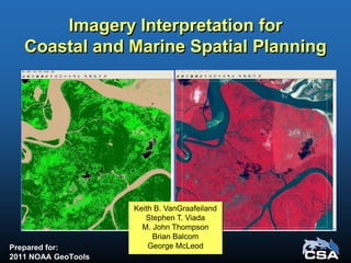
  • 1. Imagery Interpretation for Coastal and Marine Spatial Planning Prepared for: 2011 NOAA GeoTools Keith B. VanGraafeiland Stephen T. Viada M. John Thompson Brian Balcom George McLeod
  • 2. Acknowledgments Anadarko Petroleum Corporation (APC) • John Peffer • Mario Rassul • Karina Pena
  • 3. Purpose • Remote Sensing Data – Satellite imagery – Side-scan sonar • GIS Habitat Mapping – Imagery classification – Imagery interpretation • Environmental Sensitivity Analysis Methods – Identify features and areas of concern for avoidance and to minimize environmental impacts
  • 4. • Produce – Environmental Sensitivity Index (ESI) maps – Thematic maps – Statistical summaries (areal and linear dimensions) of habitat type • Support – Environmental Impact Assessments (EIAs) – Environmental Impact Studies (EISs) – Environmental Baseline Surveys (EBSs) – Monitoring plans – Spill contingency plans Purpose (Cont.)
  • 5. Case Study Northern Mozambique, Africa • A 2D and 3D geophysical survey program proposed within shallow waters of the Quirimbas Archipelago, Mozambique Study purpose • Locate seafloor features warranting environmental protection from seismic operations • Develop a mitigation plan to minimize potential environmental impacts
  • 6. Study Objectives 1. Characterize and map marine habitats 2. Identify physical areas of concern 3. Develop a mitigation plan 4. Implement a field survey to delineate areas of environmental concern Deliverables • EIA, with an approved environmental impact mitigation plan • Environmental Management Plan (EMP)
  • 7. • Mangrove-dominated communities • Submerged aquatic vegetation • Bare sand and mud substrates • Shallow and emergent hard substrates • Shallow and emergent coral communities • Deepwater coral communities Objective 1: Characterization and Mapping of Shallow Water Marine Habitats
  • 8. • A set of high resolution remote sensing (satellite imagery) tiles of the coastal and nearshore waters of the project area were used to create a georeferenced mosaic • Habitat categories were identified and coded as colored polygons, creating a georeferenced habitat map Objective 1 (Cont.)
  • 9. • ESI methods were used to determine the relative sensitivity of each identified habitat category • Sources of environmental impact – Seismic sound pressure waves – Physical contact with receiver cables and autonomous receivers Objective 2: Habitat Sensitivity Analysis
  • 10. Potential Levels of Impact Severity Impact Severity Consequence Negligible Negligible or little harm to sensitive resources, with reversible effects Little or no environmental exposure Minor Low, minor environmental impact Exposure limited to immediate site Moderate Medium, moderate environmental impact Incident potentially contaminating local resources Significant Major environmental impact (see text below) Environmental incident resulting in contamination of local resources Catastrophic Catastrophic disaster, major environmental impact Major environmental incident causing significant regional damage to the environment Scale of Environmental Sensitivity 1 Negligible 2 Minor 3 Moderate 4 Significant 5 Catastrophic Severity of Impact ––––––––►
  • 11. Objective 3: Develop a Mitigation Plan for the Protection of the Identified Areas of Concern • From the ESI results, an impact mitigation strategy was designed to avoid or minimize potential impacts to sensitive marine resources and habitats • Mitigation measures consisted of acoustic exclusion zones (“buffer zones”), considering proposed activity scenarios
  • 12. Objective 4: Field Survey • A field survey was designed and implemented to accurately and efficiently identify and delineate areas that met sensitive habitat criteria
  • 13. Field Survey Methods • Preliminary mapping survey of selected segments with digital side-scan sonar • Visual assessment (groundtruthing) of selected seafloor features by divers
  • 14. Survey Data Analysis The processed sonar data swath was superimposed on the satellite mosaic for interpretation Each proposed seismic survey trackline was superimposed on the corresponding satellite mosaic
  • 15. Survey Data Analysis (Cont.) Results obtained from groundtruthing selected targets provided supportive information for seafloor interpretation Selected groundtruth targets were plotted, and areas meeting selection criteria were provided a buffer of 75 m The final product comprised a color-coded overlay of the surveyed trackline segment
  • 16. Survey Results • 250 km were surveyed • 90 km were in water depths <2 m • 42 km were designated as sensitive habitat • 118 km did not contain sensitive habitat or were too deep to survey
  • 17. Conclusions • Sensitive shallow water habitats were mapped within the project area • Acoustic exclusion areas (buffers) for selected resources were implemented • The methods provide a practical and efficient means to characterize and map seafloor habitats within large geographic areas and may be applied to other activity scenarios and geographic areas