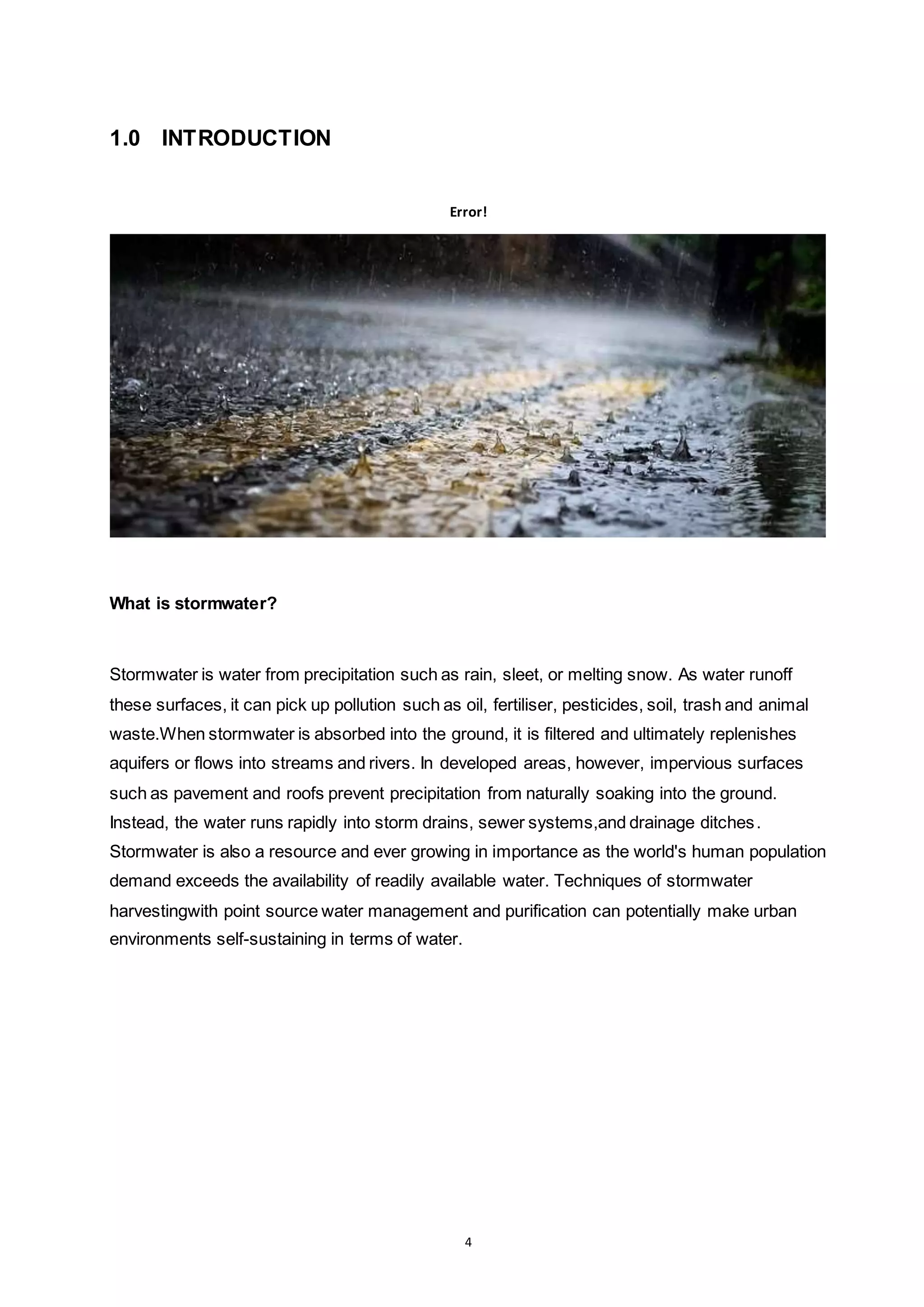
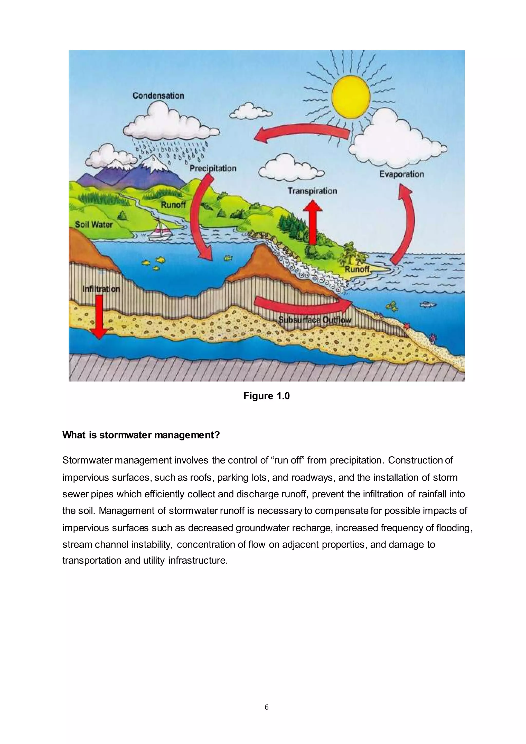
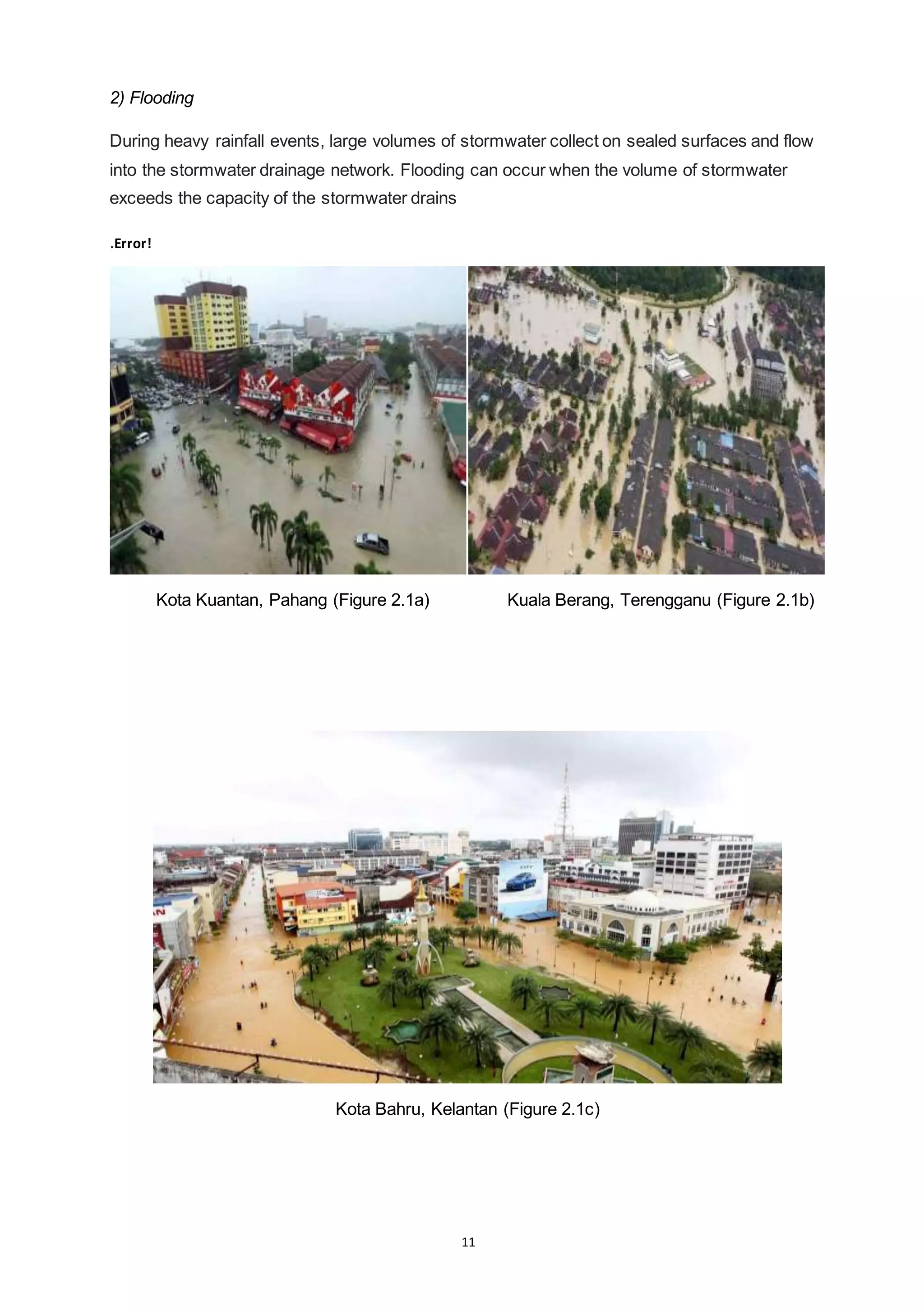
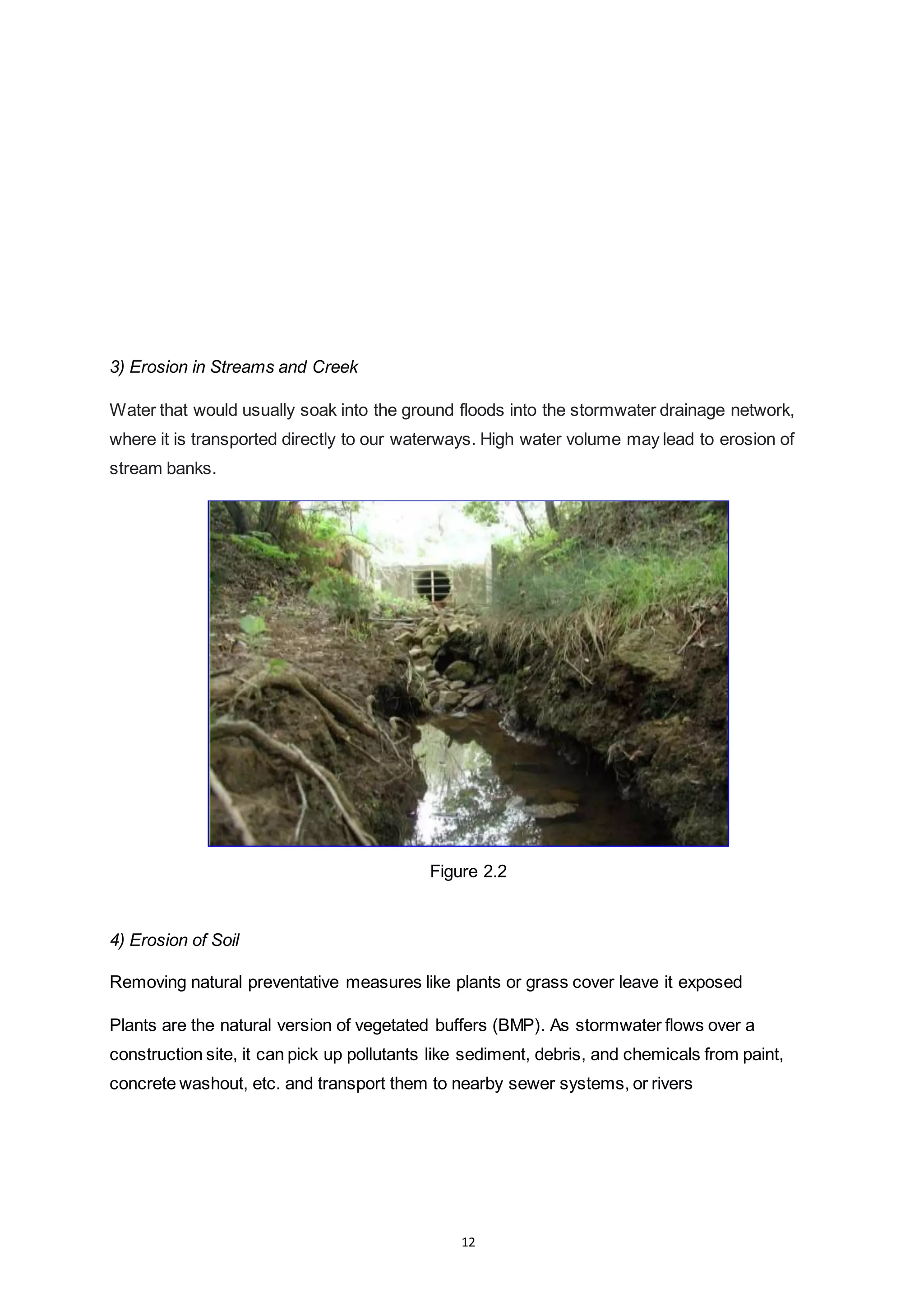
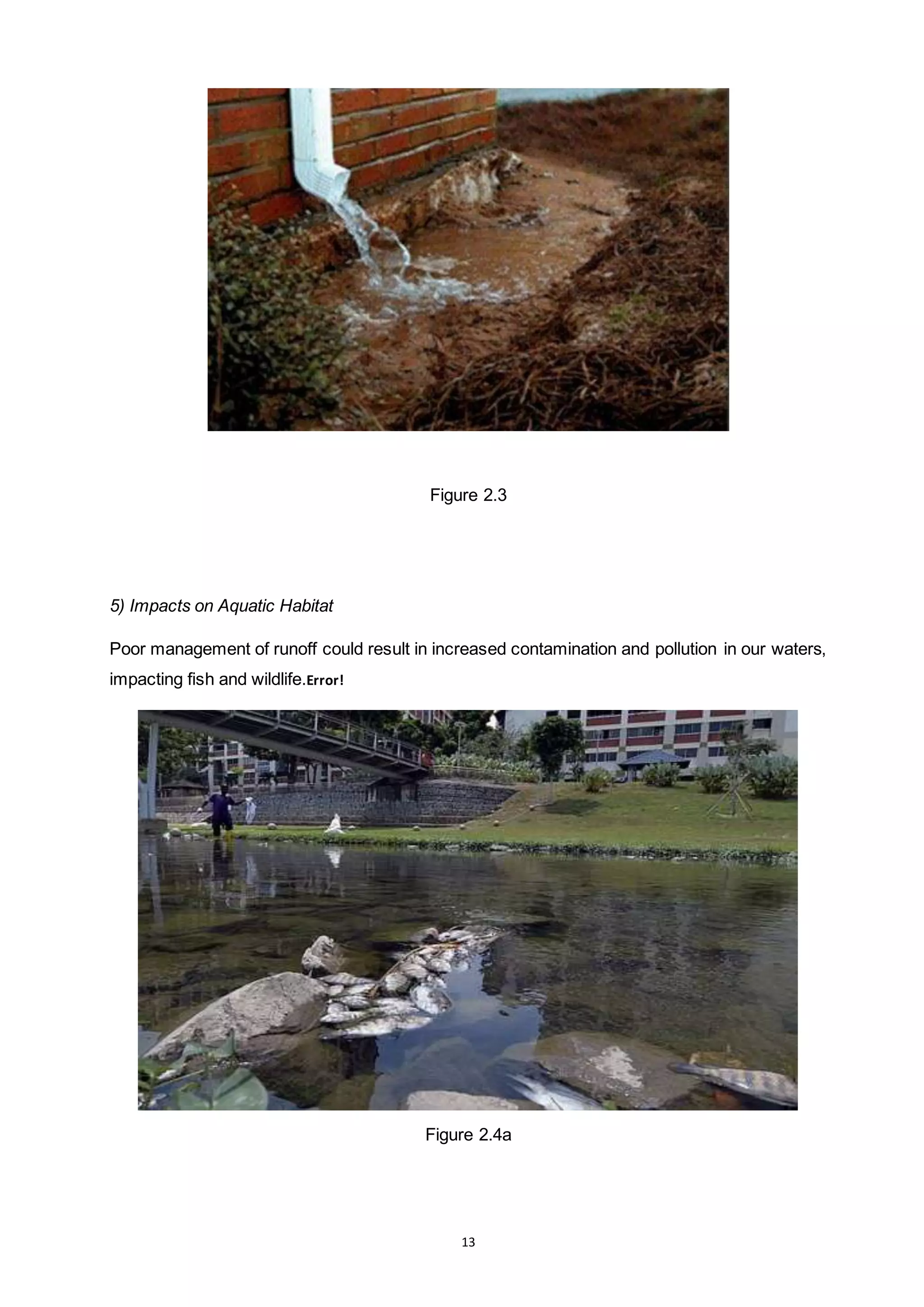
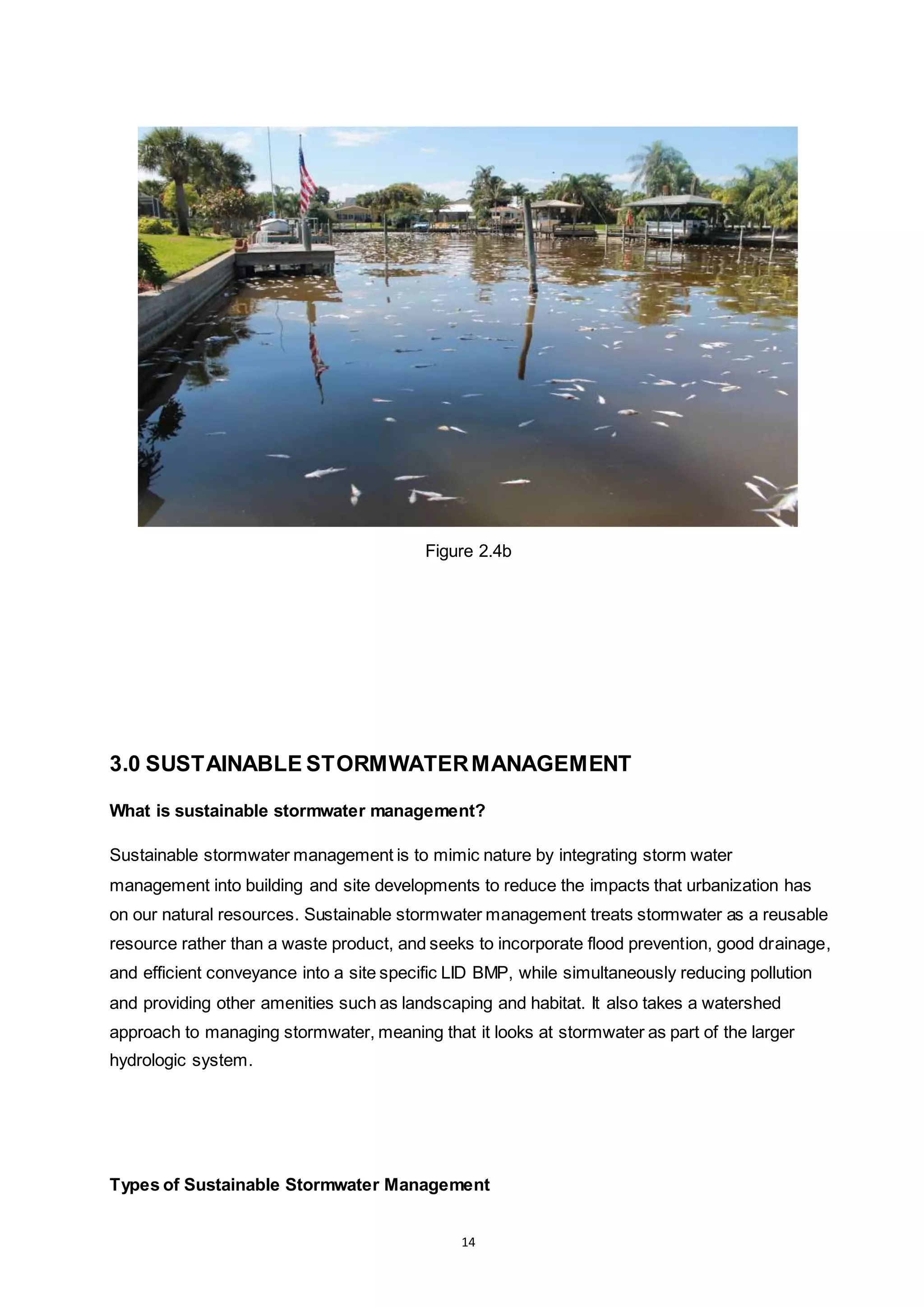
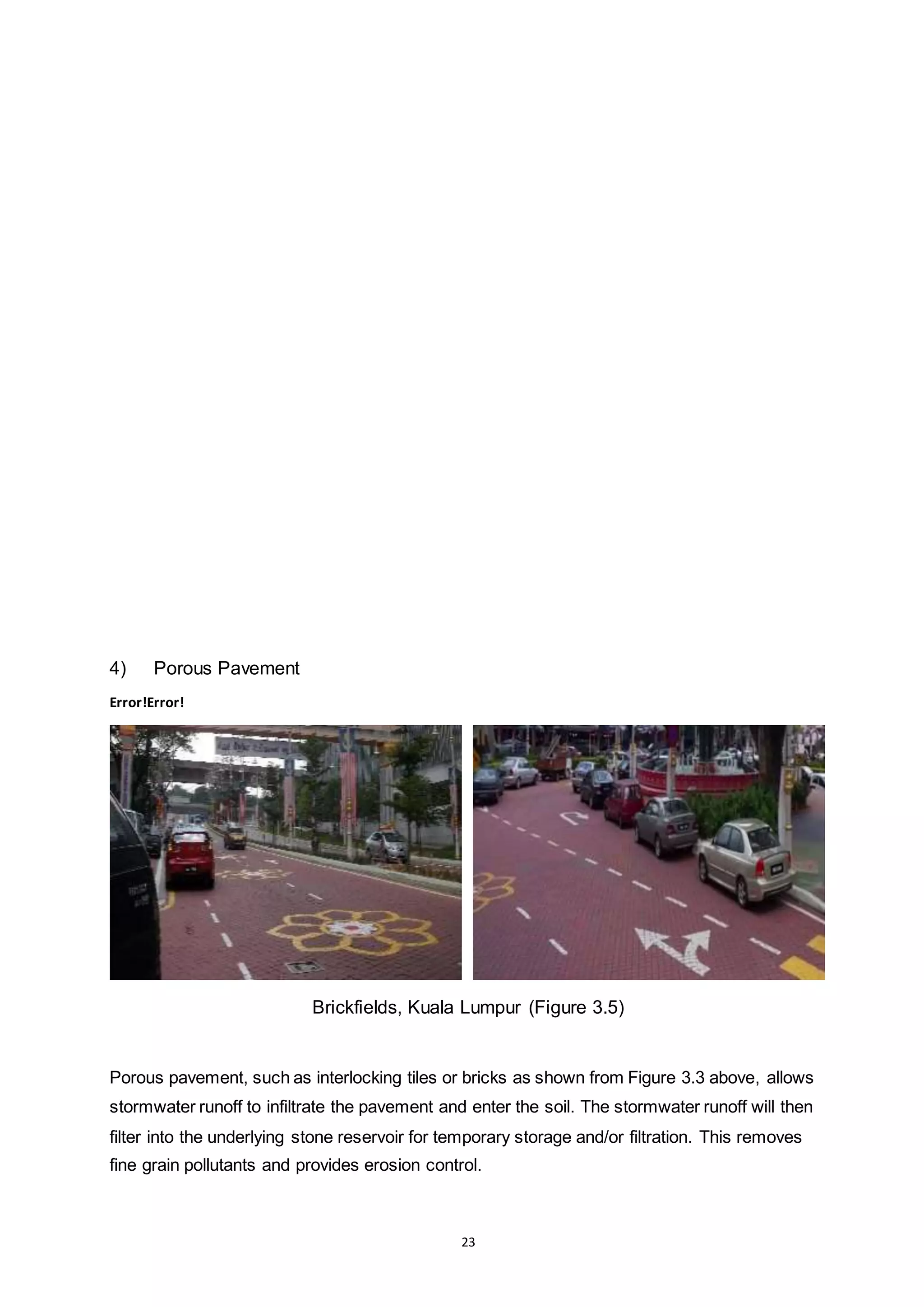
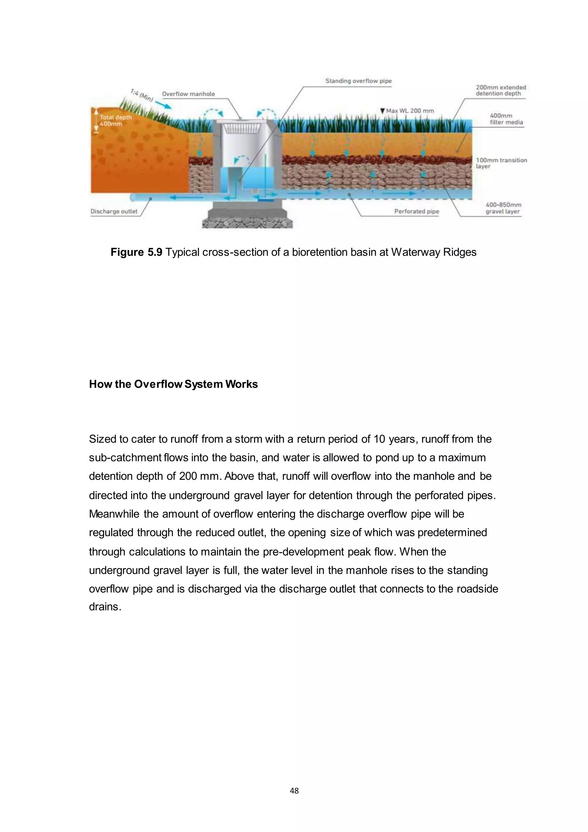
The document discusses sustainable stormwater management. It defines stormwater and explains why stormwater management is important. Poor stormwater management can lead to pollution, flooding, erosion, and impacts on aquatic habitat. Sustainable stormwater management aims to mimic natural water cycles and treat stormwater as a reusable resource. It involves best management practices (BMPs) such as detention ponds and infiltration trenches, as well as low impact development concepts like bio-retention areas and bio-swales. Sustainable stormwater management seeks to incorporate flood prevention while reducing pollution and providing amenities.
Learn about floods, its causes and its types. including many pictures to make this a fun learing slide. have fun! please comment and like! hope you love it! kisesssssssssssssssssssssssssssssssssssssssssssssssssssssssssssssssssssssssssssssssssssssssssssssssssssssssssssssssssssssssssssssssssssssssssssssssssssssssssssssssssssssssssssssssssssssssssssssssssssssssssssssss!
A REVIEW ARTICLE ON IMPACT OF URBANIZATION ON HYDROLOGICAL PARAMETERS IAEME Publication
As longas human being continues to exists,urbanization continues. Urbanizationhasa direct effect on environment which in turn effects the variations in hydrology. It may results from changes inthe land use pattern to built-up areas resulting in runoff which ultimately leads to flood. Most of the studies revealed thatland use pattern has drastically changed in whichthe builtup area increases year after year.The land use land cover changes can be identified using GIS. Many researchers have found that urbanization has an impact on hydrological parameters such as runoff volume, discharge in drains, infiltration, interception, evapotranspiration etc. An attempt has been made to consolidate the review of literature related to impact of urbanization on hydrological parameters.
Irrigation system of Pakistan proved at top level of countries in the world but still it need deep concern regarding to control flood water. Due to heavy rainfall in September 2011, floods are come in left bank of drain and it has many impacts on the various cities and villages of sindh were observed, at least 360 people were killed, some 5.35 Million people and 1.2 Million homes affected as well 1.7 Million Acres of arable land inundated. Social life was fully disturbed as economy was destroyed due to damage of crop, people were also suffering from drinking water which was not purely provided and due to this dirty water many of the diseases were appeared like direa, malaria and tified. In this research we measure the losses during heavy rain fall 2011 in Nawabshah, Sh Benazeerabad regarding to impact on our social lives and then its precautions in future planning. Data was collected from social survey in premises of city, different departments including NGO’s and Governmental Departments and also solutions on immediate basis are discussed.
On January 25, 2019, ICLR hosted a Friday Forum Webinar titled 'TRCA Flood Risk Assessment Project', led by Rebecca Elliott, water resources engineer with the Toronto and Region Conservation Authority. TRCA’s Flood Risk Assessment project recently assessed flood risk by utilizing flood hazard information from the hydrology and hydraulic modelling for seven different return-period storm events (2-350 year and Regional) at all the historic flood vulnerable areas in the Region. The purpose of this assessment was to combine current riverine flood hazard information and flood exposure information to calculate flood vulnerability and quantify flood risk at both the individual structure level and at a flood-vulnerable cluster level. Flood exposure information includes flood depth and velocity at each building and road subject to flooding for each of the seven return-period storms relative to the first floor elevation of the building. As highlighted by recent major flooding events, including the tropical rainstorm and the Spring 2017 flooding in Ontario/Quebec, as well as Hurricane Harvey’s impact to Texas, many people inhabiting flood-prone communities are not fully aware of the risks to themselves and their property. The Flood Risk Outreach project will build on the results from TRCA’s Flood Risk Assessment project by supporting public awareness of potential flood emergencies. In turn, this can lessen the impact of flooding to these areas, as residents can take preparatory steps to protect themselves and their homes. Recent studies have shown that only a small percentage of residents living in flood prone areas are aware of their flood risk.
Rebecca Elliott is a water resources engineer with 12 years of experience, and more than two years with the Toronto and Region Conservation Authority. She received her undergraduate degree from the University of Guelph with a Bachelor of Science in Water Resources Engineering, and has been a practicing Professional Engineer since 2011. As Flood Risk Management Engineer her role is to manage the flood forecasting and warning program at the TRCA.
Under the Metro Manila Flood Management Project, 36 existing pumping stations will be modernized, 20 new ones will be constructed and supporting infrastructure along critical waterways will be improved in the cities of Manila, Pasay, Taguig, Makati, Malabon, Mandaluyong, San Juan, Pasig, Valenzuela, Quezon City and Caloocan.
Stormwater runoff occurs when precipitation from rain or snowmelt flows over the land surface. Flooding also occurs due to excessive high intensity rainfall over the rate of infiltration of soils. All are natural hazards. Both of these problems are to be solved through water management practices. This module highlights all these aspects.
CAMBRIDGE AS GEOGRAPHY REVISION: HYDROLOGY AND FLUVIAL GEOMORPHOLOGY - 1.4 HU...George Dumitrache
A presentation of the fourth subchapter (The Human Impact) from the first chapter (Hydrology and Fluvial Geomorphology) of Revision for Geography AS Cambridge exam.
Atmospheric rivers are narrow bands of moisture-filled air that flow from the tropics to higher latitudes. These weather phenomena can be thousands of miles long and carry as much water vapor as the Amazon River. Atmospheric rivers have a significant impact on global climate patterns, often bringing much-needed rain to drought-stricken regions or causing devastating floods in others.
Waterproofing Repairing Basement Walls
Wet basement walls can lead to serious problems, including mold, rot, musty odors and structural damage. The problem may be as simple as hairline cracks in the concrete or as severe as bowing and buckling foundation walls. Whatever the situation, you can count on your local waterproofing contractor to diagnose and fix it with trusted, permanent solutions that include interior drainage systems, sump pumps, dehumidifiers and basement vapor barriers. Each comes with a long-term, nationally backed, transferable warranty and is designed to work together to keep your home permanently dry.
Drainage St. Louis Missouri
The drainage system of your property is an essential part of a well-designed landscape. A proper drainage system will protect your home, yard, and landscaping from excessive moisture, soil erosion, mosquito breeding, and other problems caused by too much water. At Big Bend Landscaping, we provide a wide variety of drainage solutions to fit your individual needs.
Downspout Piping Drain Grates
Downspouts are not only an important part of the water drainage system of your home; they also make it possible to collect rain and run-off water for reuse in irrigating plants, washing cars, or other outdoor activities. Downspouts are usually installed in the eaves of your home to collect and carry stormwater away from the foundation of your house, keeping it from entering your basement or other areas of your home.
French Drains
A French drain is a popular drainage solution for lawns and other landscaped areas of your home. When constructed properly a French drain will eliminate areas of standing water which can be an ideal breading ground for mosquitoes.
Generally, the term “French drain” refers to a perforated (holes drilled into the pipe for water to drain) PVC drain pipe that
How to Find Professional Drainage Contractors ?DrainagTeaame
When it comes to finding a professional drainage contractor, you need to take your time and do your research. There are many factors to consider, including experience, reputation, and pricing. Here are some tips on how to find the right drainage contractor for your needs.
An Atmospheric River (AR) storm, also known as a "Pineapple Express" in some cases, is a meteorological phenomenon characterized by a long and narrow corridor of concentrated moisture in the atmosphere. These atmospheric rivers are like "rivers in the sky" and can transport significant amounts of water vapor over vast distances.
Erosion is a natural occurrence that can damage landscapes and structures. It can also be a safety hazard, especially in slopes or downhill areas. It occurs as a result of natural factors, such as extraordinary rainfall or the lack of vegetation to hold soil in place. Erosion control is an important part of landscape design and must be taken into consideration during the planning process.
A French drain is a drainage system designed to redirect water away from a particular area, typically used to prevent water from pooling around foundations or in low-lying areas. The main component of a French drain is a perforated pipe that is installed in a trench and surrounded by gravel or crushed stone. The pipe allows water to enter and flow through it, while the gravel or crushed stone acts as a filter and provides a path for the water to move away from the area.
Corrugated Piping vs SDR35 for Downspout Drainage SystemsDrainagTeaame
When it comes to downspout drainage systems, choosing the right type of piping is crucial. Corrugated piping and SDR35 are two popular options for this purpose. While both types have their own advantages and disadvantages, it's important to understand the differences between them in order to make an informed decision.
St. Louis, Missouri is a city that has experienced its fair share of flooding due to heavy rainfall and its location on the Mississippi River. Therefore, it is crucial for residential homes in St. Louis to have efficient drainage systems. Residential drainage systems are designed to prevent water from pooling around the foundation of a home, which can cause foundation damage and mold growth.
Our Drainage Expertise & Resources
We offer a variety of drainage solutions to help keep water, snow and debris away from homes, buildings and landscapes. These systems are designed to help protect your property from flooding, structural damage and other costly repairs. Our team of professionals is trained to evaluate your home’s drainage needs and recommend the most appropriate solution.
Uncovering the Benefits of Bioretention Basin ConstructionDrainagTeaame
If you live in St Louis then you know the rain can cause major problems for homes and businesses if proper drainage systems are not in place. A proper drainage system can protect your home from foundation issues, mold and mildew and many other problems that often occur due to flooding or water pooling close to the building's foundation.
A stormwater basin is a vegetated depression designed to store and collect runoff as a permanent pool of water that removes pollutants through settling and biological uptake. Basins are used on sites where it is impractical or impossible to divert stormwater flow to downstream natural or open waters.
The basins are constructed to prevent large volumes of stormwater from rushing into nearby streams during rain and snowmelt events by holding the water until it can be slowly released into stream, soils and groundwater. Basins can be found in urban, suburban and rural settings and resemble ponds or bowl-shaped areas planted with grass.
Some basins hold water at all times, resembling ponds; others drain completely. Both types of basins are useful in reducing flooding and erosion problems associated with development on impermeable surfaces such as roads, parking lots, buildings and rooftops. In addition to preventing flood problems, basins can improve water quality by removing sediment and other pollutants from stormwater before it flows into nearby streams and rivers.
This is a presentation by Dada Robert in a Your Skill Boost masterclass organised by the Excellence Foundation for South Sudan (EFSS) on Saturday, the 25th and Sunday, the 26th of May 2024.
He discussed the concept of quality improvement, emphasizing its applicability to various aspects of life, including personal, project, and program improvements. He defined quality as doing the right thing at the right time in the right way to achieve the best possible results and discussed the concept of the "gap" between what we know and what we do, and how this gap represents the areas we need to improve. He explained the scientific approach to quality improvement, which involves systematic performance analysis, testing and learning, and implementing change ideas. He also highlighted the importance of client focus and a team approach to quality improvement.
How to Create Map Views in the Odoo 17 ERPCeline George
The map views are useful for providing a geographical representation of data. They allow users to visualize and analyze the data in a more intuitive manner.
How to Split Bills in the Odoo 17 POS ModuleCeline George
Bills have a main role in point of sale procedure. It will help to track sales, handling payments and giving receipts to customers. Bill splitting also has an important role in POS. For example, If some friends come together for dinner and if they want to divide the bill then it is possible by POS bill splitting. This slide will show how to split bills in odoo 17 POS.
The Roman Empire A Historical Colossus.pdfkaushalkr1407
The Roman Empire, a vast and enduring power, stands as one of history's most remarkable civilizations, leaving an indelible imprint on the world. It emerged from the Roman Republic, transitioning into an imperial powerhouse under the leadership of Augustus Caesar in 27 BCE. This transformation marked the beginning of an era defined by unprecedented territorial expansion, architectural marvels, and profound cultural influence.
The empire's roots lie in the city of Rome, founded, according to legend, by Romulus in 753 BCE. Over centuries, Rome evolved from a small settlement to a formidable republic, characterized by a complex political system with elected officials and checks on power. However, internal strife, class conflicts, and military ambitions paved the way for the end of the Republic. Julius Caesar’s dictatorship and subsequent assassination in 44 BCE created a power vacuum, leading to a civil war. Octavian, later Augustus, emerged victorious, heralding the Roman Empire’s birth.
Under Augustus, the empire experienced the Pax Romana, a 200-year period of relative peace and stability. Augustus reformed the military, established efficient administrative systems, and initiated grand construction projects. The empire's borders expanded, encompassing territories from Britain to Egypt and from Spain to the Euphrates. Roman legions, renowned for their discipline and engineering prowess, secured and maintained these vast territories, building roads, fortifications, and cities that facilitated control and integration.
The Roman Empire’s society was hierarchical, with a rigid class system. At the top were the patricians, wealthy elites who held significant political power. Below them were the plebeians, free citizens with limited political influence, and the vast numbers of slaves who formed the backbone of the economy. The family unit was central, governed by the paterfamilias, the male head who held absolute authority.
Culturally, the Romans were eclectic, absorbing and adapting elements from the civilizations they encountered, particularly the Greeks. Roman art, literature, and philosophy reflected this synthesis, creating a rich cultural tapestry. Latin, the Roman language, became the lingua franca of the Western world, influencing numerous modern languages.
Roman architecture and engineering achievements were monumental. They perfected the arch, vault, and dome, constructing enduring structures like the Colosseum, Pantheon, and aqueducts. These engineering marvels not only showcased Roman ingenuity but also served practical purposes, from public entertainment to water supply.
Read| The latest issue of The Challenger is here! We are thrilled to announce that our school paper has qualified for the NATIONAL SCHOOLS PRESS CONFERENCE (NSPC) 2024. Thank you for your unwavering support and trust. Dive into the stories that made us stand out!
Ethnobotany and Ethnopharmacology:
Ethnobotany in herbal drug evaluation,
Impact of Ethnobotany in traditional medicine,
New development in herbals,
Bio-prospecting tools for drug discovery,
Role of Ethnopharmacology in drug evaluation,
Reverse Pharmacology.
Students, digital devices and success - Andreas Schleicher - 27 May 2024..pptxEduSkills OECD
Andreas Schleicher presents at the OECD webinar ‘Digital devices in schools: detrimental distraction or secret to success?’ on 27 May 2024. The presentation was based on findings from PISA 2022 results and the webinar helped launch the PISA in Focus ‘Managing screen time: How to protect and equip students against distraction’ https://www.oecd-ilibrary.org/education/managing-screen-time_7c225af4-en and the OECD Education Policy Perspective ‘Students, digital devices and success’ can be found here - https://oe.cd/il/5yV
We all have good and bad thoughts from time to time and situation to situation. We are bombarded daily with spiraling thoughts(both negative and positive) creating all-consuming feel , making us difficult to manage with associated suffering. Good thoughts are like our Mob Signal (Positive thought) amidst noise(negative thought) in the atmosphere. Negative thoughts like noise outweigh positive thoughts. These thoughts often create unwanted confusion, trouble, stress and frustration in our mind as well as chaos in our physical world. Negative thoughts are also known as “distorted thinking”.
Model Attribute Check Company Auto PropertyCeline George
In Odoo, the multi-company feature allows you to manage multiple companies within a single Odoo database instance. Each company can have its own configurations while still sharing common resources such as products, customers, and suppliers.
The Indian economy is classified into different sectors to simplify the analysis and understanding of economic activities. For Class 10, it's essential to grasp the sectors of the Indian economy, understand their characteristics, and recognize their importance. This guide will provide detailed notes on the Sectors of the Indian Economy Class 10, using specific long-tail keywords to enhance comprehension.
For more information, visit-www.vavaclasses.com
1. 1
SCHOOL OF ARCHITECTURE, BUILDING AND
DESIGN
BACHELOR OF QUANTITY SURVEYING (HONOURS)
AUGUST INTAKE 2016
SUBJECT: BUILDING SERVICES 1 (BLD60403AC199)
LECTURER: MR. LEONG BOON TIK
TITLE: SUSTAINABLE STORMWATER
MANAGEMENT
NAME: ERIC WEE HIONG KIET (0329601)
WONG TIAN YI (0326891)
WONG SHER SHENG (0329950)
ANDY CHIN (0326973)
2. 2
TEO CHIANG LOONG (0323762)
NO TITLE PAGES
1 COVER PAGE 1
2 TABLE OF CONTENT 2
3 INTRODUCTION 3-6
4 EFFECT OF POOR STORMWATER
MANAGEMENT
7-10
5 SUSTAINABLE STORMWATER
MANAGEMENT
11-33
3. 3
6 CASE STUDY 34-48
7 LEARNING FROM THE GROUP WORK
PROJECT
49
8 REFERENCE 50
4. 4
1.0 INTRODUCTION
Error!
What is stormwater?
Stormwater is water from precipitation such as rain, sleet, or melting snow. As water runoff
these surfaces, it can pick up pollution such as oil, fertiliser, pesticides, soil, trash and animal
waste.When stormwater is absorbed into the ground, it is filtered and ultimately replenishes
aquifers or flows into streams and rivers. In developed areas, however, impervious surfaces
such as pavement and roofs prevent precipitation from naturally soaking into the ground.
Instead, the water runs rapidly into storm drains, sewer systems,and drainage ditches.
Stormwater is also a resource and ever growing in importance as the world's human population
demand exceeds the availability of readily available water. Techniques of stormwater
harvestingwith point source water management and purification can potentially make urban
environments self-sustaining in terms of water.
6. 6
Figure 1.0
What is stormwater management?
Stormwater management involves the control of “run off” from precipitation. Construction of
impervious surfaces, such as roofs, parking lots, and roadways, and the installation of storm
sewer pipes which efficiently collect and discharge runoff, prevent the infiltration of rainfall into
the soil. Management of stormwater runoff is necessary to compensate for possible impacts of
impervious surfaces such as decreased groundwater recharge, increased frequency of flooding,
stream channel instability, concentration of flow on adjacent properties, and damage to
transportation and utility infrastructure.
7. 7
Why is stormwater management important?
Stormwater management is important to prevent physical damage to person’s and property
from flooding and to maintain the ecological integrity, quality and quantity of our water
resources. Stormwater can also be considered a resource that provides benefits such as
groundwater recharge and flood protection.The installation of impervious surfaces interrupts the
natural hydrologic cycle, and causes less infiltration, interception, and evaporation than was
present before any development occurred. (Figure 1.1) Therefore, the volume and rate of flow
of stormwater produced by the land surface have been greatly increased. The result of this
larger amount of stormwater runoff significantly contributes to flooding, sediment deposition,
erosion, nonpoint source pollution and stream channel instability. Stormwater management
also assists with the reduction and prevention of many different sources of pollution, which
enter local waterways.Traditional stormwater management takes surface runoff and diverts it to
a detention pond, which holds the water and releases it at a constant rate over time. This
approach allows the water to be returned to the watercourse at a high volume over a longer
period of time, which does not necessarily rectify the problem and may actually create another.
If stormwater is recharged into the groundwater, it can protect against erosion, flooding, and
water quality degradation. Stormwater management can provide economic benefits to local
communities as well. Proper management can result in reduced costs and/or fees for
remediation of adverse impacts to stream channels, water quality, reduce the percentage of
flash flood, property damage and loss of life created by increased stormwater runoff.
When stormwater is absorbed into the ground, it is filtered and ultimately replenishes aquifers
or flows into streams and rivers. In developed areas, however, impervious surfaces such as
pavement and roofs prevent precipitation from naturally soaking into the ground. Instead, the
water runs rapidly into storm drains, sewer systems,and drainage.
8. 8
Figure 1.1
In hydrological perspectives, the important physical processes in hydrological cycle have been
disrupted by nowadays development. Hydrologic cycle is clearly defined as in Figure 1.0. The
surface runoff may change its flow path significantly due to the land characteristics are always
changed. With natural ground cover, 25% of rain infiltrates into the aquifer and only 10% ends
up as runoff. As imperviousness increases, less water infiltrates and more and more runs off.
In highly urbanized areas, over one-half of all rain becomes surface runoff, and deep
infiltration is only a fraction of what it was naturally.The increased surface runoff requires more
infrastructure to minimize flooding. Natural waterways end up being used as drainage channels,
and are frequently lined with rocks or concrete to move water more quickly and prevent erosion.
In addition, as deep infiltration decreases, the water table drops, reducing groundwater for
wetlands, riparian vegetation, wells, and other uses. The impact of urbanisation on the natural
stormwater cycle is shown below ;
9. 9
Figure 2.1
2.0 EFFECT OF POORWATER MANAGEMENT
1) Pollution
When water comes in contact with urban surfaces such as roofs, roads and footpaths, it
becomes contaminated with oil, metals, litter and other pollutants. The examples of these
effects can be shown in the figures below.
11. 11
2) Flooding
During heavy rainfall events, large volumes of stormwater collect on sealed surfaces and flow
into the stormwater drainage network. Flooding can occur when the volume of stormwater
exceeds the capacity of the stormwater drains
.Error!
Kota Kuantan, Pahang (Figure 2.1a) Kuala Berang, Terengganu (Figure 2.1b)
Kota Bahru, Kelantan (Figure 2.1c)
12. 12
3) Erosion in Streams and Creek
Water that would usually soak into the ground floods into the stormwater drainage network,
where it is transported directly to our waterways. High water volume may lead to erosion of
stream banks.
Figure 2.2
4) Erosion of Soil
Removing natural preventative measures like plants or grass cover leave it exposed
Plants are the natural version of vegetated buffers (BMP). As stormwater flows over a
construction site, it can pick up pollutants like sediment, debris, and chemicals from paint,
concrete washout, etc. and transport them to nearby sewer systems, or rivers
13. 13
Figure 2.3
5) Impacts on Aquatic Habitat
Poor management of runoff could result in increased contamination and pollution in our waters,
impacting fish and wildlife.Error!
Figure 2.4a
14. 14
Figure 2.4b
3.0 SUSTAINABLE STORMWATERMANAGEMENT
What is sustainable stormwater management?
Sustainable stormwater management is to mimic nature by integrating storm water
management into building and site developments to reduce the impacts that urbanization has
on our natural resources. Sustainable stormwater management treats stormwater as a reusable
resource rather than a waste product, and seeks to incorporate flood prevention, good drainage,
and efficient conveyance into a site specific LID BMP, while simultaneously reducing pollution
and providing other amenities such as landscaping and habitat. It also takes a watershed
approach to managing stormwater, meaning that it looks at stormwater as part of the larger
hydrologic system.
Types of Sustainable Stormwater Management
15. 15
Sustainable Stormwater Management can be divided into two categories:
Typical Best Management Practices (BMPs):
- Increasing topsoil
- Infiltration trenches
- Porous pavement
Typical Low Impact Development Concepts (LIDs):
- Cluster housing
- Bio-retention areas (rain gardens)
- Bio-swales
- Vegetation retention
3. 1 Best Management Practices
16. 16
Best Management Practices (BMP’s) are suggested for use by local authorities, planners,
contractors, and others involved with stormwater management, earth disturbance, and other
development activities. Best Management Practices have been designed, evaluated, and used
by various agencies and organizations; they have been proven to be efficient and effective.
Therefore, the BMPs listed below, as a general rule of thumb, are commonly accepted by local,
state, and federal regulatory agencies. Stormwater management BMP’s can be categorized as
either Nonstructural or Structural. Non-structural BMP’s are land use planning and design
approaches that have the ability to lessen and prevent stormwater. In other words, they
minimize the amount of runoff generated prior to mitigating the impacts. Structural BMP’s are
specific practices or structures that are designed and engineered to address post
Best Management Practices (BMPs) are structural, vegetative or managerial practices used to
treat, prevent or reduce water pollution. Source controls BMPs are those practices that tend to
keep both runoff and pollutants contained at their source. They are analogous to the source
controls that we speak of hydrologically. These include pervious areas and buffer strips towards
which runoff is directed, infiltration controls, porous pavement, etc.
17. 17
Examples of Structural BMPs
1) Detention Ponds
Figure 3.0
Instead of flowing directly to a river, stormwater can be transported to a detention pond. These
ponds hold the water until pollutants settle to the bottom. Wet ponds allow incoming stormwater
runoff to replace pond water. When pond water flows out, the new runoff is stored in the pond
until the next storm. This system enables many of the runoff pollutants to settle to the bottom of
the pond. Detention facilities are designed principally to reduce peak flow rates from large
infrequent storm events. This prevents pollutants from entering the river, but provides minimal
flood protection. Figure 3.0 shows a detention pond of a project of Maktab Perguruan
Perempuan Melayu Melaka 2007.
Detention techniques include the temporary storage of runoff in the building:
Small on-site tanks and above-ground storage areas
Dry detention basins
Ponds and wetlands
19. 19
Figure 3.2
Stormwater infiltration practices capture and temporarily store stormwater before allowing it to
infiltrate into the soil. Infiltration practices are applicable to sites with naturally permeable soils
and a suitable distance to the seasonally high groundwater table, bedrock or other
impermeable layer. They may be used in residential and other urban settings where
elevated runoff volumes, pollutant loads, and runoff temperatures are a concern. Stormwater
runoff having high pollutant loads should receive a significant amount of pretreatment to protect
the groundwater quality, particularly if soil infiltration rates are high. Runoff from potential
stormwater hotsposts (PSH) should not be introduced to infiltration areas. Infiltration should be
avoided in areas with contaminated soils or groundwater. Infiltration is a suitable technique for
in infiltrating pre-treated runoff into areas with relatively high permeability soils.
Advantages and Disadvantages of infiltration basin
Advantages Disadvantages
-Reduces the volume of runoff from a drainage
area
-Can be very effective at pollutant removal via
-Potentially high failure rates due to improper
siting, poor design and lack of maintenance,
especially if appropriate pre-treatment is not
incorporated
20. 20
filtering through the soils
-Contributes to groundwater recharge and
baseflow augmentation
-Simple and cost-effective to construct
-Changes in performance easy to observe.
-Comprehensive geotechnical investigations
required to confirm suitability for infiltration
-Not appropriate for draining pollution hotspots
where high pollution concentrations are
possible
-Requires a large, flat area.
Examples of Infiltration basin in Malaysia
Sungai Kelantan Infiltration Basin(Figure 3.3)
Shah Alam Seksyen 7 Infiltration Basin (Figure 3.4)
21. 21
3) Infiltration trench
Error!
Error!
Figure 3.4
Infiltration tranches are shallow (1 to 3.5meter) excavations that are lined with filter fabric and
filled with stone to create underground reservoirs for stormwater runoff from a specific design
storm. The runoff gradually percolates through bottom and sides of the trench into the
surrounding subsoil over a period of days. Infiltration trenches are typically implemented at the
ground surface to intercept overland flows.
Function of Infiltration trench
Infiltration trenches provide total peak discharge, runoff volume and water quality control for all
storm events equal to or less than the design storm. This infiltration reduces the volume of
runoff, removes many pollutants and proves stream base flow and groundwater recharge.
A general guideline for groundwater protection is to design infiltration trenches with the bottom
of the trench a minimum of 1 meter above the high groundwater table. If the water table is too
close to the ground surface, infiltration practices should not be used.
22. 22
Advantages of Infiltration Trenches
1. It can reduce the volume of runoff from a drainage area
2. It can be very effective for removing fine sediment, trace metals, nutrients, bacteria and
oxygen-demanding substances (organics)
3. It can reduce downstream flooding and protects steambank integrity
4. It can reduces the size and cost of downstream stormwater control facilities and/or storm
drain systems by infiltrating stormwater in upland areas
5. It provides groundwater recharge and baseflow in nearby streams
6. It reduces local flooding
7. It appropriate for small sites (2 acres or less)
8. It can be utilized where space is limited, due to their narrow dimensions.
23. 23
4) Porous Pavement
Error!Error!
Brickfields, Kuala Lumpur (Figure 3.5)
Porous pavement, such as interlocking tiles or bricks as shown from Figure 3.3 above, allows
stormwater runoff to infiltrate the pavement and enter the soil. The stormwater runoff will then
filter into the underlying stone reservoir for temporary storage and/or filtration. This removes
fine grain pollutants and provides erosion control.
24. 24
The most commonly used permeable pavement surfaces are pervious concrete, porous asphalt,
and permeable interlocking concrete pavers. Permeable pavements have been used for areas
with light traffic at commercial and residential sites to replace traditional impervious surfaces in
low-speed roads, alleys, parking lots, driveways, sidewalks, plazas, and patios. While
permeable pavements can withstand truck loads, permeable pavement has not been proven in
areas exposed to high repetitions of trucks or in high speed areas because its’ structural
performance and surface stability have not yet been consistently demonstrated in such
applications.
While design details vary, all permeable pavements have a similar structure, consisting of a
surface pavement layer, an underlying stone aggregate reservoir layer, optional underdrains
and geotextile over uncompacted soil subgrade. From a hydrologic perspective, permeable
pavement is typically designed to manage rainfall landing directly on the permeable pavement
surface. Permeable pavement surfaces may accept runoff contributed by adjacent impervious
areas such as driving lanes or rooftops. The capacity of the underlying reservoir limits the
contributing area. Run-on from adjacent vegetated areas is generally not recommended and if it
occurs, must be stabilized and not generate sediment as its transport accelerates permeable
pavement surface clogging
How porous pavement works
25. 25
Figure 3.6
Components of porous pavement
Directly below the pavement is called the bedding layer. Which helps make sure the paver
surfaces is flat once the installation is complete. The base and sub-base layers are made of
lager size stones. Similar to what is used in the railway tracks. This is where rainwater can be
store until it drains into the natural soil to recharge ground water just like the nature intended.
How it works
When rain falls on or water runs to the pavement, it flows through the joints between the pavers
and into the stone or aggregate below. Depending on the soil type, the water will either drain
into the ground or build up within the stone. The underlying pipe below provides overflow for
extreme weather events. Once the storm or rain is over, the remaining water will continue to
drain into the ground.
Bedding layer
Base
Sub-Baselayer
26. 26
5) Water Quality Inlets
API Separator Tank (Figure 3.7a)
Plate Separator (Figure 3.7b)
Water quality inlets are also known as oil/grease separators. These separators remove
sediments, oils and greases from parking lots prior to discharge to the storm drain or infiltration
basin. Oil separation devices are applicable for stormwater runoff from areas where
hydrocarbon products are handled or where small spills routinely fall on paved surfaces
exposed to rain.
The objective of the oil separators is to treat most of the flow (90 to 95%) from a potentially
contaminated catchment to an acceptable degree (10 – 20 mg/l oil and grease) and to remove
27. 27
free floating oil. High rates of runoff and practical limitations on the treatment process mean that
oil separators can only be used for small catchment areas. For Malaysian conditions the
practical maximum catchment area that can be treated is in the order of 1000 m2 ( 0.1 hectare).
More relevant applications are for :
- service stations
- yards where petroleum products are stored or handled, or vehicles are serviced, and
- heavily used highway parking lots
Types of Separator
API tanks(Figure 3.7a) and plate separators(Figure 3.7b) are the more efficient oil separators.
API tanks were originally designed by the American Petroleum Institute (API) for use in refinery
applications, but modifications of the design can be used for stormwater treatment. Besides,
there are also alternative separators such as Flow-Through Separators(Figure 3.8) and Swirl
Separators(Figure 3.9) as shown below :
Flow-Through Separator (Figure 3.8)
28. 28
Swirl Separator (Figure 3.9
3.2 Low ImpactDevelopment(LIDs)
Low-Impact Development (LID) is a stormwater management approach that seeks to manage
runoff using distributed and decentralized micro-scale controls. LID’s goal is to mimic a site’s
predevelopment hydrology by using design techniques that infiltrate, filter, store, evaporate, and
detain runoff close to its source. Instead of conveying and treating stormwater solely in large
end-of-pipe facilities located at the bottom of drainage areas, LID addresses stormwater
through small-scale landscape practices and design approaches that preserve natural drainage
features and patterns. They are cost-effective, sustainable and environment-friendly features
for urban stormwater management. The cost is a small percentage of the total capital cost of
the development, while the resulting environmental benefits are many. The image below shows
an example of Low Impact Development
30. 30
Figure 4.2
Implemented on this lot (Figure 4.2)
i. Bio-swale
ii. Rain Garden
iii. Pervious deck
iv. Pervious walkway
v. Rain Storage
vi. Vegetation Retention
vii. Green Roof/Roof Garden
31. 31
Example
This is the example of a typical Low Impact Development (LIDs) concept in a residential project.
32. 32
Figure 4.3
Components of Low Impact Development (LIDs)
1) Vegetated Swales
Error!
Figure 4.5
Vegetated swales are natural drainage channels with mild slope. They are used to remove soil
particles and convey stormwater via overland flow. They protect downstream treatment
elements or waterways from damage by erosive flows from frequent storm events because flow
velocities are slower for vegetated swales than concrete-lined drains. They can be used in
combination with bioretention systems (eg. located upstream of a bioretention swale).
Application and Principles
Vegetated swales are widely applicable at residential estates, parks and other sites. The
landscape design of vegetated swales addresses stormwater quality while incorporating
landscape functions. As such, it is important that vegetated swales are carefully designed to
integrate with the characteristics of the surrounding landscape. In Malayisa, where rainfall
33. 33
intensity is high, vegetated swales are applicable for small catchment areas (e.g. small
perimeters or compound drains and roadside drains near the summit point or use with an
overflow system).
The interaction between stormwater flow and vegetation within the vegetated swales facilitates
pollutant settlement and detention. Vegetated swales alone usually cannot provide sufficient
treatment to meet the stormwater treatment or water quality objectives as it has limited
capability to remove soluble nutrients. However, vegetated swales are particularly good at
removing coarse sediments and can provide the necessary pre-treatment for downstream
treatment systems such as wetlands and bioretention systems.
Figure 4.6 Typical section of a vegetated swale
Advantages
• Reduces flow velocities and protect downstream waterways from erosive flow during storms
• Provides effective pre-treatment for downstream like bioretention swales, rain gardens or
constructed wetlands by trapping coarse particles
34. 34
• Beautifies the surrounding landscape and may also help to satisfy green space requirements
• Functions as a cost-effective natural drainage system for small catchments
Operation & Maintenance
Vegetated swales have a flow conveyance role that needs to be maintained to ensure adequate
flood protection. In this regard, a key maintenance requirement is to ensure that the
cross-section profile of the vegetated swale is maintained and that it is not subjected to erosion
or excessive deposition of debris or overgrown vegetation that may impede the passage of
stormwater.
Maintenance of vegetated swales primarily consists of:
• Routine inspection of inlet and overflow points to clear any blockage
• Routine removal of litter, debris and sediments
• Routine inspection and repair of the vegetated swale profile
• Maintaining healthy vegetation growth – regular care, such as weeding, mowing, pruning and
pest-control, is necessary
• Removal and management of invasive weeds
2) Bioretention swales
Error!
35. 35
Figure 4.7
Bioretention swales are vegetated swales with bioretention systems located within the base.
They provide efficient treatment of stormwater runoff and are designed with gentle gradient and
temporary ponding (extended detention) to facilitate infiltration. Runoff is cleaned as it
percolates downwards. The filtered water is then collected by perforated subsoil pipes and
re-used on site or conveyed to downstream waterways.
Application and Principles
Bioretention swales can be widely applied to treat runoff from roads, car parks, residential areas
and parklands, etc. They can form attractive streetscapes and landscape features in many
urban developments.
Surface runoff is first filtered through the surface vegetation, removing coarse to medium
sediments. It then percolates through a filter media where fine particles are removed and
soluble nutrients are taken up by the roots of the plants and soil microbes. Vegetation plays a
key role in maintaining the porosity of the soil media of the bioretention system and also in the
taking up of nutrients from the percolating surface runoff. The plants selected must be able to
withstand both wet and dry conditions. They should have fibrous root systems to help keep the
filter media porous. It is preferable for plants with good nutrient removal capabilities to be
selected.
36. 36
Figure 4.7 Typical section of a bioretention swale
Advantages
• Reduces flow velocities and settles coarse sediments
• Encourages habitat creation and promotes biodiversity
• Beautifies surrounding landscape
• Filters and cleans water naturally without the use of any chemicals
Operation and Maintenance
Bioretention swales have a flow conveyance role that needs to be maintained to ensure
adequate flood protection. In this regard, a key maintenance requirement is to ensure that the
shape of the bioretention swale is maintained and that it is not subjected to erosion or excessive
deposition of debris that may impede the passage of stormwater. The inlet points and overflow
points or pits have to be kept clear.
Typical maintenance of bioretention swale elements will involve:
• Routine inspection and repair of the bioretention swale profile
• Routine inspection of inlet and overflow points to clear any blockage
• Routine removal of litter, debris and sediment
• Raking of the bioretention swale surface and flushing of the subsoil perforated pipes if there is
evidence of clogging
• Maintenance of healthy vegetation growth, as it plays a key role in maintaining the porosity of
the soil media and the taking up of nutrients from percolating surface runoff.
37. 37
3) Rain Gardens
Figure 4.8 Rain Garde (Refer to Fig 4.2)
Bioretention basins are vegetated land depressions designed to detain and treat stormwater
runoff. Their treatment process is the same as bioretention swales; the runoff is filtered through
densely planted surface vegetation and then percolated through a prescribed filter media (soil
layer). Unlike bioretention swales, they do not convey stormwater runoff.
Application and Principles
Similar to bioretention swales, impurities are removed through sedimentation, filtration and
some biological take-up (by plants, bacteria, etc). Rain gardens can be installed at various
scales and shapes: in planter boxes or integrated with streetscapes. They can also act as
‘standalone’ soil filtration systems within residential areas, parklands, schools, carparks and
other developments.
The vegetation in a bioretention system is a vital functional element of the system both in terms
of maintaining the hydraulic conductivity of the filter media and the taking up of nutrients. The
plants selected for bioretention basins should have fibrous root systems to help keep the soil
porous, and be able to withstand wet and dry conditions. It is also good to select plants with
good nutrient-removal capabilities.
38. 38
Figure 4.9 Typical section of a Rain Garden
Advantages
• Reduces flow velocities
• Encourages habitat creation and promotes biodiversity
• Beautifies surrounding landscape
• Filters and cleans water naturally without the use of any chemicals
Operation & Maintenance
Vegetation plays a key role in maintaining the porosity of the surface of the filter media and the
taking up of nutrients from percolating surface runoff. It also facilitates the transport of oxygen to
the soil microbial communities for the biological transformation of pollutants. Thus, a strong
healthy growth of vegetation is critical to its performance.
39. 39
Maintenance is primarily concerned with:
• Maintenance of depression profile to keep a clear flow path to and through the bioretention
basin
• Routine inspection of inlet, outlet and overflow points to clear any blockage
• Routine removal of litter, debris and sediment
• Raking of the bioretention basin surface and flushing of the subsoil perforated pipes if there is
evidence of clogging
• Maintaining healthy vegetation growth, as it plays a key role in maintaining the porosity of the
soil media and the taking up of nutrients from the percolating surface runoff.
4) Green roofs/Roof Garden
Green Roof or Roof Garden is a multi-layered system with living plants growing on roof top.
Green roofs, by their very nature, absorb rainwater and help to mitigate flooding. The benefits,
as they relate to water, are straightforward: for the building owner, it’s a stormwater
management tool; for the community, it reduces stormwater runoff; and for the environment, it
prevents combined sewer overflow, neutralizes the acid rain effect and removes nitrogen
pollution from the rainwater.
40. 40
Figure 4.9 Green roof
Advantages Disadvantages
Expand roof life 2x3 times (up to 60 years)
Improve aesthetic value
Reduce stormwater runoff
Neutralize acid rain effect
An increase in weight load
High installation and maintenance cost
Structural Limitation
More examples of LIDs
41. 41
Figure 5.0 Pervious Deck (Refer to Fig 4.2)
Figure 5.1 Pervious Walkway (Refer to Fig 4.2)
42. 42
Figure 5.2 Rain Storage (Refer to Fig 4.2)
Figure 5.3 Shrubs/Plantings (Refer to Fig 4.2)
43. 43
4.0 CASE STUDY
1) Waterway Ridges, Singapore
Figure 5.4 Waterway Ridges Project
Located at:
44. 44
Figure 5.5 Location
Background of Waterway Ridges, Singapore
Waterway Ridges in Punggol is a 3.98 hectare public housing project that
demonstrates how the collection, detention, treatment and conveyance of stormwater
runoff can be integrated with a residential development at a precinct level. While
maintaining the pre-development hydrology of the site for all storm events up to a 10
year return period, the holistic integration of ABC Waters design features into
residential spaces also brings additional benefits to the community and the
environment in terms of improving runoff quality, creating multi-functional spaces,
enhancing aesthetics and promoting biodiversity.
Figure 5.6
45. 45
The main challenge of Waterway Ridges was to design a stormwater drainage system
that could regulate the runoff rate from the precinct as well as improve runoff water
quality. ABC Waters design features are located at both the Common Green and
Waterway Ridges precinct, slowing down flows collectively to maintain the
pre-development peak runoff rate (up to a 10 year return period) and cleansing
stormwater to improve water quality.
Intergrated Stormwater Management Solution Of This Project
Figure 5.7
Indicative drainage flow paths in Waterway Ridges. Stormwater runoff is conveyed,
detained and treated through a series of bioretention basins and vegetated swales
before being discharged from the development into the roadside drains, Punggol
Waterway and Tributary A.
46. 46
Due to site constraints, runoff from about 70% of the total site runoff would be
channelled through a comprehensive train of rain gardens and vegetated swales
meandering through the development. Normally dry, these aesthetically pleasing
gardens and swales would be filled with stormwater runoff during rainy weather,
acting as temporary detention basins and treatment features before being discharged
into the public drains.
Figure 5.8
From the figure above, bioretention basin during dry weather (left). During a rain event
(right), stormwater is directed into the swale, reducing the velocity and volume of
runoff into the drainage system.
47. 47
As space at the ground level had to be set aside for public amenities (e.g.
playgrounds, lawns, etc.), the amount of space available for surface detention was
limited. Thus, underground detention space was implemented in addition to surface
detention. This was done through the use of gravel storage layers, with depths
ranging from 400 to 850 mm, which were located within or below the bioretention
basins and integrated with the drainage layer (refer to the figure below Figure 5.8)
Overflow System Design
48. 48
Figure 5.9 Typical cross-section of a bioretention basin at Waterway Ridges
How the Overflow System Works
Sized to cater to runoff from a storm with a return period of 10 years, runoff from the
sub-catchment flows into the basin, and water is allowed to pond up to a maximum
detention depth of 200 mm. Above that, runoff will overflow into the manhole and be
directed into the underground gravel layer for detention through the perforated pipes.
Meanwhile the amount of overflow entering the discharge overflow pipe will be
regulated through the reduced outlet, the opening size of which was predetermined
through calculations to maintain the pre-development peak flow. When the
underground gravel layer is full, the water level in the manhole rises to the standing
overflow pipe and is discharged via the discharge outlet that connects to the roadside
drains.
49. 49
Since aesthetics and public amenities on the ground level are important for such a
development, plants of high aesthetic value and which encourage biodiversity were
incorporated into the design features for conveyance and detention. The design
features were also designed as multi-functional spaces, able to be used during dry
weather as public amenities. For example, selected bioretention basins would serve
as communal lawns, where residents can enjoy recreational activities during dry
weather. As such, through holistic planning, peak runoff reduction and runoff water
quality improvement can be achieved, while creating a beautiful environment rich in
biodiversity for residents to enjoy.
Dry
Weather
Wet
Weather
50. 50
Figure 6.0 Bio-Retention Basin at Waterway Ridges
The figure above shows the before and after of the rain events of the bio retention
basin. Bioretention basin serving as a multi-purpose lawn during dry weather. During
a rain event, it acts as a temporary detention feature for stormwater runoff.
Impact of This Project
51. 51
Figure 6.1
The first picture above shows the pre-development peak runoff from a greenfield site.
Before the land is developed, the peak runoff rate is 1.04 m3/s. After the development,
the peak runoff rate is 1.85m3/s. With the use of onsite stormwater detention and
retention along with the conventional drainage system, there is about 37% reduction
in the peak runoff at the rate of 1.16m3/s which is much more closer to the
pre-development peak runoff rate. Thus, the impact of the project is significant.
2) Marina Barrage SingaporeError!
Error!
Figure 6.2
52. 52
Marina Barrage is a dam built across the Marina Channel creating a fresh water
reservoir in downtown Singapore. It is an engineering masterpiece which spans the
Marina Channel. It is built across the mouth of Marina Channel. Marina barrage
creates Singapore’s 15th
reservoir. Besides offering a source of water supply and
creating a recreational venue for water activities, it helps to reduce flood risks in
low-lying areas in the city (e.g. Chinatown). Marina Barrage also offers a spectacular
view of Singapore's city skyline. Its Green Roof is a perfect location for picnicking and
kite-flying. This is the island’s largest and most urbanized catchment with a catchment
area of 10000 hectares. Marina Reservoir has increased Singapore’s water
catchment from half to two-thirds of the country’s land area. It was officially opened on
1 November 2008. It provides water storage, flood control and recreation. The overall
project cost S$226 million.
Function
The barrage offers three benefits: a new source of water supply, flood control and
lifestyle attraction.
53. 53
Water Supply
Figure 6.3
Marina barrage made great contribution in water supply in Singapore. It is more than a
simple dam. The barrage forms Singapore’s first reservoir in the city the Marina
Reservoir. First of all, it stores the rainwater while rainwater is the most abundant
water resources especially in tropical country such as Singapore. So if every drop of
rain is preserved, then the shortage of water resources would be solved. Furthermore,
it collects water from sea and desalinates seawater into fresh water. Since Singapore
is an island surrounded by sea, thus sea is also an important source of water. The
water that flow into the reservoir are purified to be reused. Freshwater treated using
advanced membrane technology. The barrage helps to increase the local water
supply source which is one of the Four National Taps.
54. 54
Flood control
Figure 6.4
Before the construction of Marina Barrage, low lying areas of the city were prone to
flooding. The barrage helps alleviate flooding in these low lying areas. It controls the
water level in Marina reservoir by making it free from tidal influence. The flood control
operations consist of 9 crest gates and 7 drainage pumps. During low tide and heavy
storm, the crest gates will be lowered to release excess stormwater into the sea. This
is to prevent flooding in the areas upstream. During high tide, the crest gates can’t be
lowered. In such situation, the seven pumps will be activated to pump excess
stromwater from the reservoir into the sea.
55. 55
Lifestyle attraction
Figure 6.5
As the water in the Marina Basin is unaffected by the tides, it is ideal for various types
of water activities such as windsurfing, boating and dragonboating. The greenroof of
the Visitor centre is also another popular site for recreational activities.
56. 56
Application of The Marina Barrage and Reservoir Mechanism
The Marina Barrage divides fresh water in the Marina Bay Reservoir from the salty
waters of the South Chinese Sea. Incorporated in the barrage are nine large steel
gates, each more than 30 meters tall, that can be raised or lowered depending on the
need. As the water level in the reservoir rises, the gates angle downwards, releasing
water out to sea but preventing the entry of water from the sea into the reservoir.
Additionally, seven advanced large drainage turbines, installed near the bottom of the
barrage, can also rapidly pump water out to sea.
57. 57
Figure 6.6
Left: Marina Barrage mechanism, showing vertical “closed” gates.
Right: Marina Barrage, with “closed” gates.
Figure 6.7
Left: Marina Barrage mechanism, showing diagonally tilted “open” gates.
Right: Marina Barrage, with “open” gates; excess water from the reservoir is
released.
Beneficial Impact of Marina Barrage to Sinagapore
58. 58
Having little water resources, Singapore has built a sustainable water supply system
called the National Four Taps, including local catchment, imported water, reclaimed
water and desalinated water. Marina Barrage is the first reservoir that is used for
catching rain water in Singapore. There are three main functions of Marina Barrage:
water storage, flood control as well as lifestyle attraction.
First of all, Marina Barrage is used to store rain water. As we know, Singapore has a
tropical rain forest climate. Therefore, it rains a lot here. Then how to make use of the
abundant rain water? Built across the Marina Channel, Marina Barrage is used for
storing rain water and separating fresh water from sea water.
Besides from storing fresh water, Marina Barrage can also prevent Singapore from
being flooded. Since it has a high average rainfall here every year, there will be
inevitable floods if there is too much rain in a short period of time. When it is raining too
heavily and the sea is at low tide, the steel crest gates of the barrage will be lowered
and the water in the reservoir will be released into the sea. Similarly, if the sea is at
high tide, the water in the reservoir will be drained into the sea by the drainage pumps.
Marina Barrage also acts as a tidal barrage to keep the seawater out, helping to
alleviate flooding in low lying areas of the city such as Chinatown, Jalan Besar and
Geylang.
Lastly, Marina Barrage provides a new lifestyle for Singaporeans. A part of the
reservoir is used as a water playground where people can play all kinds of recreational
activities such as boating, river cruises and water competitions etc. Apart from bring
different experiences for people; these water activities will also inform people of the
importance of water conservation.
To sum up, water storage, flood control and lifestyle attraction are the three main
aspects of how Marina Barrage benefit Singapore. Marina Barrage is definitely a great
project that helps Singapore to solve the problem of lacking natural water resources.
59. 59
Awards
1. Singapore Quality Award
Superior Achievement Award, American Academy of Environment Engineers (AA
EE)'s Excellence in Environment Engineering Competition
2. Innovation Excellence Award
Grand Conceptor award for American Council of Engineering Companies of
Massachusett's 2009
3. Singapore Quality Class
ASEAN Outstanding Engineering Achievement Award
4. Singapore Innovation Class
BCA Green Mark Platinum Award for Infrastructure
5. Singapore Quality Award
60. 60
IES Prestigious Engineering Achievement Awards
Error!4.1 CONCLUSION OF CASE STUDY
Singapore’s pioneering and versatile Marina Barrage and Waterway Ridge provides
an essential fresh water supply, alleviates flooding, and even serves as a recreational
facility. The project also demonstrates that holistic planning and collaboration
between public agencies, private entities and the citizenry can together attain a more
intelligent use of a scarce resource like water. It is clear that the necessary conditions
for the successful realization and continuation of such a project are the product of an
entire nation’s loyalty to strict water safety regulations. For that reason, it is important
to view the Marina Barrage and Waterway Ridge not only as a novel piece of physical
infrastructure, but also as a symbol of the political and social infrastructure that
enabled its fulfillment. Error!
61. 61
5.0 LEARNING FROM THE GROUPWORK PROJECT
Our group consist of 5 members which are Eric Wee Hiong Kiet, Wong Tian Yi,
Wong Sher Sheng, Andy Chin and Teo Chiang Loong. Since there are 5 of us, work
load are distributed evenly among us with the agreement and consent from each
andevery one of us.
As this assignment comes to an end, we have gained plenty of new knowledge
throughout this assignment. First of all, we learn the basics of stormwater
management and how it works in an urban city. Stormwater management mainly is to
control the flow rate of storm water runoff and distribute the runoff evenly to prevent
flood. At the same time, it is also to maintain the water quality for drinking purposes
and daily usage.
62. 62
Besides, we also get to know about how Singapore tackle stormwater challenges
and their system. From the case study, it shows that how systematic is of the
stormwater management system that Singapore possess. Based on the case in
Waterway Ridges, we see how efficient the way they tackle the stormwater runoff.
This project have additional benefits to the community and the environment in terms
of improving runoff quality, creating multi-functional spaces which simultaneously
enhancing aesthetics and promoting biodiversity.
On the other hand, we also learned a lot from our second case study which is the
Marina Barrage. From this particular case study, we discover that how a dam can be
beneficial to Singapore in terms of water supply, flood control and lifestyle attraction.
We are immensely astonished by the beauty of this engineering marvel as it is not
only a beautiful infrastructure but also very beneficial to the citizens. Marina Barrage
is also often used as a symbol of the political and social infrastructure that enabled its
fulfillment.
Furthermore, we also learnt how to analyze and interpret data in order to
determine every piece of information is usable. For example, there are limitations to
some technologies that is not conventional to be used in Malaysia due to the weather
and geometric factors. Hence, it is a challenging to our critical thinking skills when it
comes to applying those technology from the information found on the internet.
Last but not least, we learned the importance of cooperation among members to
accomplish a task. Not to mention, time management. Without a proper time
management, we would not have complete this assignment in time.
Error!